South East
§ This page provides an overview of UK's South East region, with key facts and data. Last updated on .
Overview ⁞ The South East of England is the UK’s most populous region, combining economic dynamism with historic charm. It is known for its commuter belt towns, historic cities, and iconic landmarks such as the White Cliffs of Dover, Windsor Castle, and the South Downs National Park. The economy is driven by finance, technology, tourism, and education.
The region’s governance includes a mix of two-tier counties, unitary authorities, and historic cities. Its proximity to London fuels strong transport links and property demand, with many towns serving as commuter hubs.
Ceremonial Counties in South East region
The South East comprises 9 ceremonial counties: Berkshire, Buckinghamshire, East Sussex, Hampshire, Isle of Wight, Kent, Oxfordshire, Surrey, and West Sussex. These counties offer a mix of countryside, coastline, and thriving towns.
Districts in South East
The UK is divided into Local Authority Districts (LADs) as the main building blocks of local government and statistical geography. The following lists all the LADs in this region.
- Unitary Authorities ▸ Bracknell Forest ⁞ Brighton and Hove ⁞ Buckinghamshire ⁞ Isle of Wight ⁞ Medway ⁞ Milton Keynes ⁞ Portsmouth ⁞ Reading ⁞ Slough ⁞ Southampton ⁞ West Berkshire ⁞ Windsor and Maidenhead ⁞ Wokingham
- East Sussex ▸ Eastbourne ⁞ Hastings ⁞ Lewes ⁞ Rother ⁞ Wealden
- Hampshire ▸ Basingstoke and Deane ⁞ East Hampshire ⁞ Eastleigh ⁞ Fareham ⁞ Gosport ⁞ Hart ⁞ Havant ⁞ New Forest ⁞ Rushmoor ⁞ Test Valley ⁞ Winchester
- Kent ▸ Ashford ⁞ Canterbury ⁞ Dartford ⁞ Dover ⁞ Folkestone and Hythe ⁞ Gravesham ⁞ Maidstone ⁞ Sevenoaks ⁞ Swale ⁞ Thanet ⁞ Tonbridge and Malling ⁞ Tunbridge Wells
- Oxfordshire ▸ Cherwell ⁞ Oxford ⁞ South Oxfordshire ⁞ Vale of White Horse ⁞ West Oxfordshire
- Surrey ▸ Elmbridge ⁞ Epsom and Ewell ⁞ Guildford ⁞ Mole Valley ⁞ Reigate and Banstead ⁞ Runnymede ⁞ Spelthorne ⁞ Surrey Heath ⁞ Tandridge ⁞ Waverley ⁞ Woking
- West Sussex ▸ Adur ⁞ Arun ⁞ Chichester ⁞ Crawley ⁞ Horsham ⁞ Mid Sussex ⁞ Worthing
Cities in South East
South East is home to several officially designated cities, each holding city status by royal charter rather than population size alone. Below is a complete list of cities in the region, including their local authorities, administrative geography, ceremonial honours, and the year city status was granted.
Chichester parish
- Local authority
- Chichester (District Council)
- City council (status holder)
- Chichester parish (Civil parish)
- Ceremonial county
- West Sussex
- Civic honour
- No additional civic honour
- City status granted
- 1075
City of Oxford
- Local authority
- Oxford (Non-metropolitan borough)
- Ceremonial county
- Oxfordshire
- Civic honour
- Lord Mayor
- City status granted
- 1542
City of Portsmouth
- Local authority
- Portsmouth (Unitary authority)
- Ceremonial county
- Hampshire
- Civic honour
- Lord Mayor
- City status granted
- 1926
City of Southampton
- Local authority
- Southampton (Unitary authority)
- Ceremonial county
- Hampshire
- Civic honour
- Lord Mayor
- City status granted
- 1964
City of Canterbury
- Local authority
- Canterbury (Non-metropolitan borough)
- Ceremonial county
- Kent
- Civic honour
- Lord Mayor
- City status granted
- 1974
City of Winchester
- Local authority
- Winchester (Non-metropolitan borough)
- Ceremonial county
- Hampshire
- Civic honour
- No additional civic honour
- City status granted
- 1974
Brighton and Hove
- Local authority
- Brighton and Hove (Unitary authority)
- Ceremonial county
- East Sussex
- Civic honour
- No additional civic honour
- City status granted
- 2001
City of Milton Keynes
- Local authority
- Milton Keynes (Unitary authority)
- Ceremonial county
- Buckinghamshire
- Civic honour
- No additional civic honour
- City status granted
- 2022
Post Towns in South East
Below is a complete list of post towns in South East, grouped by postcode area to make browsing easier.
- BN ▸ Arundel ⁞ Brighton ⁞ Eastbourne ⁞ Hailsham ⁞ Hassocks ⁞ Henfield ⁞ Hove ⁞ Lancing ⁞ Lewes ⁞ Littlehampton ⁞ Newhaven ⁞ Peacehaven ⁞ Pevensey ⁞ Polegate ⁞ Seaford ⁞ Shoreham-by-Sea ⁞ Steyning ⁞ Worthing
- CR ▸ Caterham ⁞ Coulsdon ⁞ Croydon ⁞ Kenley ⁞ Mitcham ⁞ Purley ⁞ South Croydon ⁞ Thornton Heath ⁞ Warlingham ⁞ Whyteleafe
- CT ▸ Birchington ⁞ Broadstairs ⁞ Canterbury ⁞ Deal ⁞ Dover ⁞ Folkestone ⁞ Herne Bay ⁞ Hythe ⁞ Margate ⁞ Ramsgate ⁞ Sandwich ⁞ Westgate-on-Sea ⁞ Whitstable
- DA ▸ Belvedere ⁞ Bexley ⁞ Bexleyheath ⁞ Dartford ⁞ Erith ⁞ Gravesend ⁞ Greenhithe ⁞ Longfield ⁞ Sidcup ⁞ Swanscombe ⁞ Welling
- GU ▸ Aldershot ⁞ Alton ⁞ Bagshot ⁞ Bordon ⁞ Camberley ⁞ Cranleigh ⁞ Farnborough ⁞ Farnham ⁞ Fleet ⁞ Godalming ⁞ Guildford ⁞ Haslemere ⁞ Hindhead ⁞ Lightwater ⁞ Liphook ⁞ Liss ⁞ Midhurst ⁞ Petersfield ⁞ Petworth ⁞ Sandhurst ⁞ Virginia Water ⁞ Windlesham ⁞ Woking ⁞ Yateley
- HP ▸ Amersham ⁞ Aylesbury ⁞ Beaconsfield ⁞ Berkhamsted ⁞ Chalfont St. Giles ⁞ Chesham ⁞ Great Missenden ⁞ Hemel Hempstead ⁞ High Wycombe ⁞ Princes Risborough ⁞ Tring
- KT ▸ Addlestone ⁞ Ashtead ⁞ Chertsey ⁞ Chessington ⁞ Cobham ⁞ East Molesey ⁞ Epsom ⁞ Esher ⁞ Kingston upon Thames ⁞ Leatherhead ⁞ New Malden ⁞ Surbiton ⁞ Tadworth ⁞ Thames Ditton ⁞ Walton-on-Thames ⁞ West Byfleet ⁞ West Molesey ⁞ Weybridge ⁞ Worcester Park
- LU ▸ Dunstable ⁞ Leighton Buzzard ⁞ Luton
- ME ▸ Aylesford ⁞ Chatham ⁞ Faversham ⁞ Gillingham ⁞ Maidstone ⁞ Queenborough ⁞ Rochester ⁞ Sheerness ⁞ Sittingbourne ⁞ Snodland ⁞ West Malling
- MK ▸ Bedford ⁞ Buckingham ⁞ Milton Keynes ⁞ Newport Pagnell ⁞ Olney
- PO ▸ Bembridge ⁞ Bognor Regis ⁞ Chichester ⁞ Cowes ⁞ East Cowes ⁞ Emsworth ⁞ Fareham ⁞ Freshwater ⁞ Gosport ⁞ Havant ⁞ Hayling Island ⁞ Lee-on-the-Solent ⁞ Newport ⁞ Portsmouth ⁞ Rowland's Castle ⁞ Ryde ⁞ Sandown ⁞ Seaview ⁞ Shanklin ⁞ Southsea ⁞ Totland Bay ⁞ Ventnor ⁞ Waterlooville ⁞ Yarmouth
- RG ▸ Basingstoke ⁞ Bracknell ⁞ Crowthorne ⁞ Henley-on-Thames ⁞ Hook ⁞ Hungerford ⁞ Newbury ⁞ Reading ⁞ Tadley ⁞ Thatcham ⁞ Whitchurch ⁞ Wokingham
- RH ▸ Betchworth ⁞ Billingshurst ⁞ Burgess Hill ⁞ Crawley ⁞ Dorking ⁞ East Grinstead ⁞ Forest Row ⁞ Gatwick ⁞ Godstone ⁞ Haywards Heath ⁞ Horley ⁞ Horsham ⁞ Lingfield ⁞ Oxted ⁞ Pulborough ⁞ Redhill ⁞ Reigate
- SL ▸ Ascot ⁞ Bourne End ⁞ Gerrards Cross ⁞ Iver ⁞ Maidenhead ⁞ Marlow ⁞ Slough ⁞ Windsor
- SM ▸ Banstead ⁞ Carshalton ⁞ Morden ⁞ Sutton ⁞ Wallington
- SO ▸ Alresford ⁞ Brockenhurst ⁞ Eastleigh ⁞ Lymington ⁞ Lyndhurst ⁞ Romsey ⁞ Southampton ⁞ Stockbridge ⁞ Winchester
- TN ▸ Ashford ⁞ Battle ⁞ Bexhill-on-Sea ⁞ Cranbrook ⁞ Crowborough ⁞ Edenbridge ⁞ Etchingham ⁞ Hartfield ⁞ Hastings ⁞ Heathfield ⁞ Mayfield ⁞ New Romney ⁞ Robertsbridge ⁞ Romney Marsh ⁞ Rye ⁞ Sevenoaks ⁞ St. Leonards-on-Sea ⁞ Tenterden ⁞ Tonbridge ⁞ Tunbridge Wells ⁞ Uckfield ⁞ Wadhurst ⁞ Westerham ⁞ Winchelsea
- TW ▸ Ashford ⁞ Brentford ⁞ Egham ⁞ Feltham ⁞ Hampton ⁞ Hounslow ⁞ Isleworth ⁞ Richmond ⁞ Shepperton ⁞ Staines-upon-Thames ⁞ Sunbury-on-Thames ⁞ Teddington ⁞ Twickenham
International Territorial Levels in South East Region
The International Territorial Levels (ITLs) are a hierarchical system of geographic boundaries used for statistical purposes, specifically for regional data analysis and international comparisons. It has three levels: ITL1, ITL2, and ITL3, with ITL1 being the broadest level and ITL3 the most detailed.
South East Region is one of ITL 1 areas in the UK. It is then divided ino the following ITL 2 areas (names in bold letters) and ITL 3 areas.
- Berkshire, Buckinghamshire and Oxfordshire — Milton Keynes ⁞ Buckinghamshire ⁞ Oxfordshire CC ⁞ Berkshire East ⁞ Berkshire West
- Surrey, East and West Sussex — Brighton and Hove ⁞ East Sussex CC ⁞ West Surrey ⁞ East Surrey ⁞ West Sussex (South West) ⁞ West Sussex (North East)
- Hampshire and Isle of Wight — Portsmouth ⁞ Southampton ⁞ Isle of Wight ⁞ South Hampshire ⁞ Central Hampshire ⁞ North Hampshire
- Kent — Medway ⁞ Kent Thames Gateway ⁞ East Kent ⁞ Mid Kent ⁞ West Kent
Constituencies in South East
The region contains 91 parliamentary constituencies, ranging from densely populated commuter towns to rural districts and coastal resorts. Its size and population make it highly influential in national politics.
- Aldershot
- Arundel and South Downs
- Ashford
- Aylesbury
- Banbury
- Basingstoke
- Beaconsfield
- Bexhill and Battle
- Bicester and Woodstock
- Bognor Regis and Littlehampton
- Bracknell
- Brighton Kemptown and Peacehaven
- Brighton Pavilion
- Buckingham and Bletchley
- Canterbury
- Chatham and Aylesford
- Chesham and Amersham
- Chichester
- Crawley
- Dartford
- Didcot and Wantage
- Dorking and Horley
- Dover and Deal
- Earley and Woodley
- East Grinstead and Uckfield
- East Hampshire
- East Surrey
- East Thanet
- East Worthing and Shoreham
- Eastbourne
- Eastleigh
- Epsom and Ewell
- Esher and Walton
- Fareham and Waterlooville
- Farnham and Bordon
- Faversham and Mid Kent
- Folkestone and Hythe
- Gillingham and Rainham
- Godalming and Ash
- Gosport
- Gravesham
- Guildford
- Hamble Valley
- Hastings and Rye
- Havant
- Henley and Thame
- Herne Bay and Sandwich
- Horsham
- Hove and Portslade
- Isle of Wight East
- Isle of Wight West
- Lewes
- Maidenhead
- Maidstone and Malling
- Mid Buckinghamshire
- Mid Sussex
- Milton Keynes Central
- Milton Keynes North
- New Forest East
- New Forest West
- Newbury
- North East Hampshire
- North West Hampshire
- Oxford East
- Oxford West and Abingdon
- Portsmouth North
- Portsmouth South
- Reading Central
- Reading West and Mid Berkshire
- Reigate
- Rochester and Strood
- Romsey and Southampton North
- Runnymede and Weybridge
- Sevenoaks
- Sittingbourne and Sheppey
- Slough
- Southampton Itchen
- Southampton Test
- Spelthorne
- Surrey Heath
- Sussex Weald
- Tonbridge
- Tunbridge Wells
- Weald of Kent
- Winchester
- Windsor
- Witney
- Woking
- Wokingham
- Worthing West
- Wycombe
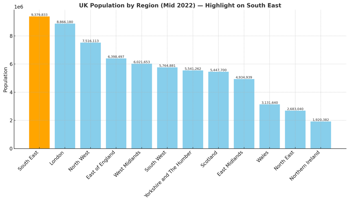
Population of South East England
South East England is the most populous region in England, with over 9.38 million people (mid-2022, ONS). Covering 19,072 square kilometres (7,364 square miles), the region has a population density of 492 people per square kilometre.
How it compares to the rest of England
- Population share: The South East is home to 16.4% of England’s total 57.1 million residents, placing it 1st out of 9 regions for population size.
- Population density: With 492 people per km², it is more densely populated than the national average of 438 people per km²—54 people per km² higher—ranking 3rd out of 9 regions for population density.