Fareham
§ This page gives an overview of the Fareham local authority district, bringing together key facts, maps, and data to help you quickly understand the area. This is one of 361 LAD profiles on Baseview.
Overview ⁞ Fareham, on the south coast of Hampshire, sits between Portsmouth and Southampton, with a town centre characterised by historic streets, markets, and modern amenities. The River Meon flows into the Solent nearby, with the coastal areas offering marinas and sailing. The district includes Portchester, with its striking Roman fort and castle overlooking Portsmouth Harbour, and Titchfield, with abbey ruins and nature reserves. Rolling countryside, coastal inlets, and suburban communities shape Fareham’s varied geography.
Fareham Boundary Map
This map shows the official boundary of the Fareham local authority district, based on the latest geographic data published by the Office for National Statistics (ONS). It provides a clear view of the district’s extent and helps you understand how the area fits within the wider regional and national landscape.
Contains OS data © Crown copyright and database right 2025. Source: Office for National Statistics licensed under the Open Government Licence v3.0.
The administrative boundary of Fareham can also be viewed on OpenStreetMap: District Boundary of Fareham.
Key Facts about Fareham
What region is Fareham in? Fareham is in the South East of England, a region within the UK.
What county is Fareham in? Fareham is located in the county of Hampshire.
Is Fareham a city? No, Fareham is not a city. (Note: the UK has 76 officially designated cities.)
Who governs Fareham? The local authority for this district is: Fareham Borough Council - responsible for district-level services. Since Hampshire is a two-tier area, county-level services are handled by: Hampshire County Council.
▶ Official website of Fareham Borough Council 🔗 fareham.gov.uk

Which police force covers Fareham? Policing in Fareham is provided by Hampshire Constabulary 🔗 hampshire.police.uk, which serves 14 local authority districts: Basingstoke and Deane ⁞ East Hampshire ⁞ Eastleigh ⁞ Fareham ⁞ Gosport ⁞ Hart ⁞ Havant ⁞ Isle of Wight ⁞ New Forest ⁞ Portsmouth ⁞ Rushmoor ⁞ Southampton ⁞ Test Valley ⁞ Winchester.
Constituencies in Fareham
Fareham is divided into 3 parliamentary constituencies, listed below in alphabetical order.
A constituency is a specific geographical area that elects one Member of Parliament (MP) to represent them in the House of Commons. The United Kingdom is divided into 650 parliamentary constituencies. We have this list page for easy browsing of all UK parliamentary constituencies: List of Constituencies.
Wards in Fareham
Fareham is divided into 16 wards, listed below in alphabetical order.
- Avenue
- Fareham Park
- Fareham Town
- Fort Fareham
- Hill Head
- Hook-with-Warsash
- Locks Heath
- Park Gate
- Portchester Castle
- Portchester Wicor
- Sarisbury & Whiteley
- Stubbington
- Titchfield
- Titchfield Common
- Uplands & Funtley
- Wallington & Downend
In the UK, a ward is a subdivision of a local authority area, used mainly for electoral and statistical purposes. Defined by the ONS, wards represent the primary unit for local elections, each returning one or more councillors to the local council. Wards are also used as a key geography for presenting population and census data. We have this list page for easy browsing of all electoral wards: List of all Electoral Wards in the UK.
Parishes in Fareham
Fareham is entirely unparished—there are no civil parishes in this local authority district.
Parishes are the lowest tier of local government; where they don’t exist, those very local services and representation sit directly with the principal council. We have this list page for easy browsing of all parishes: List of Civil Parishes in England and Wales.
Post Towns in Fareham
Below is a list of post towns in Fareham, grouped by postcode area:
PO ▸ Fareham (PO14 / PO15 / PO16 / PO17)
The UK postal hierarchy begins with broad postcode areas (such as “CB” or “M”), which are divided into smaller postcode districts (such as “CB8” or “M1”) to support accurate mail routing. Each postal address is anchored by a designated post town, the official locality name used in the UK postcode system, which operates independently from Local Authority Districts —the administrative boundaries used for council tax and local government services. Because they serve different purposes, a property’s postal address and its local authority district do not always align exactly.
Built-up Areas in Fareham
Fareham covers 9 built-up areas, listed below in alphabetical order.
- Fareham *
- Gosport *
- Hook Park Estate
- Knowle *
- Lee-on-the-Solent *
- Locks Heath *
- Peel Common *
- Portsmouth *
- Whiteley *
In the UK, a Built-up Area (BUA) is a continuous urban area of at least 20 hectares (0.2 km²), defined by the ONS as land where buildings are generally no more than 200 metres apart, such as towns, cities, or large villages. (Note: A BUA name marked with an asterisk (*) indicates that the area is situated partly in the district of Fareham.)
We have this list page for easy browsing of all built-up areas: List of all Built-up Areas in GB.
Railway Stations in Fareham
Fareham is served by a number of National Rail stations, providing rail connections to nearby towns, cities, and destinations across Great Britain. The railway stations listed below are located within the Fareham Local Authority District and are grouped by train operating company for clarity.
- South Western Railway ▸ Fareham (PO16 0UT) ⁞ Swanwick (SO31 1BA) ⁞ Portchester (PO16 8BJ)
This is a district-level view only. For a complete list of all National Rail stations across Great Britain, see the UK National Rail Stations Directory.
Fareham compared with other districts in the UK
This section shows how Fareham compares with other local authority districts in the UK, using a variety of measures and rankings.
Fareham has 16 electoral wards.

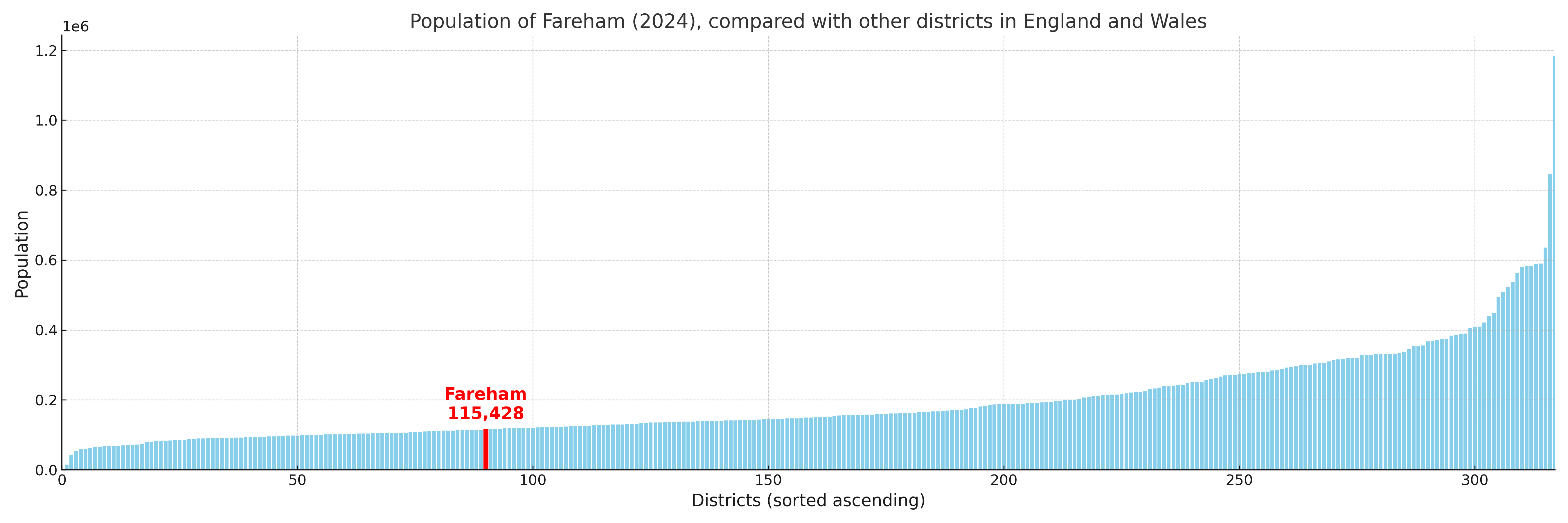
Fareham has a population of 115,428 (2024 mid-year estimate by ONS)

Population and Migration Trends in Fareham
This chart shows the population trend for Fareham from 2015 to 2024. It provides a quick overview of whether the local authority is growing, stable, or declining over time, and helps set context for the migration patterns shown below.
Population change is influenced by natural change (births minus deaths) and migration. The net migration chart below focuses on migration, separating internal migration (moves within the UK) from international migration (moves to and from abroad). Positive values indicate net inflows, while negative values indicate net outflows. The rate labels (per 1,000 residents) help compare migration intensity across years, even when the population size changes.
More local statistics and data for Fareham can be found on the ONS statistics for Fareham.