West Oxfordshire
§ This page gives an overview of the West Oxfordshire local authority district, bringing together key facts, maps, and data to help you quickly understand the area. This is one of 361 LAD profiles on Baseview.
Overview ⁞ West Oxfordshire covers a largely rural area stretching into the Cotswolds. Witney, the main town, is known for its blanket-making heritage, while Chipping Norton and Burford are charming Cotswold towns with stone houses and historic streets. The River Windrush and Evenlode valleys shape the landscape, while Blenheim Palace, a UNESCO World Heritage Site near Woodstock, is a landmark estate with parkland and lakes. Rolling hills, meadows, and Cotswold villages make this district quintessentially rural and scenic.
West Oxfordshire Boundary Map
This map shows the official boundary of the West Oxfordshire local authority district, based on the latest geographic data published by the Office for National Statistics (ONS). It provides a clear view of the district’s extent and helps you understand how the area fits within the wider regional and national landscape.
Contains OS data © Crown copyright and database right 2025. Source: Office for National Statistics licensed under the Open Government Licence v3.0.
The administrative boundary of West Oxfordshire can also be viewed on OpenStreetMap: District Boundary of West Oxfordshire.
Key Facts about West Oxfordshire
What region is West Oxfordshire in? West Oxfordshire is in the South East of England, a region within the UK.
What county is West Oxfordshire in? West Oxfordshire is located in the county of Oxfordshire.
Is West Oxfordshire a city? No, West Oxfordshire is not a city. (Note: the UK has 76 officially designated cities.)
Who governs West Oxfordshire? The local authority for this district is: West Oxfordshire District Council - responsible for district-level services. Since Oxfordshire is a two-tier area, county-level services are handled by: Oxfordshire County Council.
▶ Official website of West Oxfordshire District Council 🔗 westoxon.gov.uk
Which police force covers West Oxfordshire? Policing in West Oxfordshire is provided by Thames Valley Police 🔗 thamesvalley.police.uk, which serves 13 local authority districts: Bracknell Forest ⁞ Buckinghamshire ⁞ Cherwell ⁞ Milton Keynes ⁞ Oxford ⁞ Reading ⁞ Slough ⁞ South Oxfordshire ⁞ Vale of White Horse ⁞ West Berkshire ⁞ West Oxfordshire ⁞ Windsor and Maidenhead ⁞ Wokingham.
Constituencies in West Oxfordshire
West Oxfordshire is divided into 3 parliamentary constituencies, listed below in alphabetical order.
A constituency is a specific geographical area that elects one Member of Parliament (MP) to represent them in the House of Commons. The United Kingdom is divided into 650 parliamentary constituencies. We have this list page for easy browsing of all UK parliamentary constituencies: List of Constituencies.
Wards in West Oxfordshire
West Oxfordshire is divided into 27 wards, listed below in alphabetical order.
- Alvescot and Filkins
- Ascott and Shipton
- Bampton and Clanfield
- Brize Norton and Shilton
- Burford
- Carterton North East
- Carterton North West
- Carterton South
- Chadlington and Churchill
- Charlbury and Finstock
- Chipping Norton
- Ducklington
- Eynsham and Cassington
- Freeland and Hanborough
- Hailey, Minster Lovell and Leafield
- Kingham, Rollright and Enstone
- Milton-under-Wychwood
- North Leigh
- Standlake, Aston and Stanton Harcourt
- Stonesfield and Tackley
- The Bartons
- Witney Central
- Witney East
- Witney North
- Witney South
- Witney West
- Woodstock and Bladon
In the UK, a ward is a subdivision of a local authority area, used mainly for electoral and statistical purposes. Defined by the ONS, wards represent the primary unit for local elections, each returning one or more councillors to the local council. Wards are also used as a key geography for presenting population and census data. We have this list page for easy browsing of all electoral wards: List of all Electoral Wards in the UK.
Parishes in West Oxfordshire
West Oxfordshire is fully parished: 83 civil parishes, listed A-Z below.
- Alvescot
- Ascott-under-Wychwood
- Asthall
- Aston, Cote, Shifford and Chimney
- Bampton
- Black Bourton
- Bladon
- Blenheim
- Brize Norton
- Broadwell
- Bruern
- Burford
- Carterton
- Cassington
- Chadlington
- Charlbury
- Chastleton
- Chilson
- Chipping Norton
- Churchill
- Clanfield
- Combe
- Cornbury and Wychwood
- Cornwell
- Crawley
- Curbridge
- Ducklington
- Enstone
- Eynsham
- Fawler
- Fifield
- Filkins and Broughton Poggs
- Finstock
- Freeland
- Fulbrook
- Glympton
- Grafton and Radcot
- Great Tew
- Hailey
- Hanborough
- Hardwick-with-Yelford
- Heythrop
- Holwell
- Idbury
- Kelmscott
- Kencot
- Kiddington with Asterleigh
- Kingham
- Langford
- Leafield
- Lew
- Little Faringdon
- Little Tew
- Lyneham
- Milton-under-Wychwood
- Minster Lovell
- North Leigh
- Northmoor
- Over Norton
- Ramsden
- Rollright
- Rousham
- Salford
- Sandford St. Martin
- Sarsden
- Shilton
- Shipton-under-Wychwood
- South Leigh and High Cogges
- Spelsbury
- Standlake
- Stanton Harcourt
- Steeple Barton
- Stonesfield
- Swerford
- Swinbrook and Widford
- Tackley
- Taynton
- Westcot Barton
- Westwell
- Witney
- Woodstock
- Wootton
- Worton
A civil parish is the lowest tier of local government in England, used for villages, small towns, and suburbs. They have their own local authority, either a parish council or a parish meeting, which provides local services like managing parks, allotments, and streetlights, and represents the community's views to larger councils.
We have this list page for easy browsing of all parishes: List of Civil Parishes in England and Wales.
Post Towns in West Oxfordshire
Below is a list of post towns in West Oxfordshire, grouped by postcode area:
- OX ▸ Bampton (OX18) ⁞ Burford (OX18) ⁞ Carterton (OX18) ⁞ Chipping Norton (OX7) ⁞ Witney (OX28 / OX29) ⁞ Woodstock (OX20)
The UK postal hierarchy begins with broad postcode areas (such as “CB” or “M”), which are divided into smaller postcode districts (such as “CB8” or “M1”) to support accurate mail routing. Each postal address is anchored by a designated post town, the official locality name used in the UK postcode system, which operates independently from Local Authority Districts —the administrative boundaries used for council tax and local government services. Because they serve different purposes, a property’s postal address and its local authority district do not always align exactly.
Built-up Areas in West Oxfordshire
West Oxfordshire covers 54 built-up areas, listed below in alphabetical order.
- Alvescot
- Ascott-under-Wychwood
- Aston (West Oxfordshire)
- Bampton (West Oxfordshire)
- Black Bourton
- Bladon *
- Bledington *
- Brighthampton
- Brize Norton
- Burford
- Carterton
- Cassington
- Chadlington
- Charlbury
- Chipping Norton
- Churchill (West Oxfordshire)
- Clanfield (West Oxfordshire)
- Combe
- Cornwell
- Curbridge (West Oxfordshire)
- Delly End
- Ducklington
- Enstone
- Eynsham
- Farmoor *
- Filkins
- Finstock
- Freeland
- Fulbrook
- Gagingwell
- Great Rollright
- Hailey
- Hardwick (West Oxfordshire)
- Kencot
- Kingham
- Langford (West Oxfordshire)
- Leafield
- Little Tew
- Long Hanborough
- Middle Barton
- Milton-under-Wychwood and Shipton-under-Wychwood
- Minster Lovell
- North Leigh
- Over Norton
- Ramsden
- Standlake
- Stanton Harcourt
- Stonesfield
- Sutton (West Oxfordshire)
- Tackley
- Upper Rissington *
- Witney
- Woodstock *
- Wootton (West Oxfordshire)
In the UK, a Built-up Area (BUA) is a continuous urban area of at least 20 hectares (0.2 km²), defined by the ONS as land where buildings are generally no more than 200 metres apart, such as towns, cities, or large villages. (Note: A BUA name marked with an asterisk (*) indicates that the area is situated partly in the district of West Oxfordshire.)
We have this list page for easy browsing of all built-up areas: List of all Built-up Areas in GB.
Railway Stations in West Oxfordshire
West Oxfordshire is served by a number of National Rail stations, providing rail connections to nearby towns, cities, and destinations across Great Britain. The railway stations listed below are located within the West Oxfordshire Local Authority District and are grouped by train operating company for clarity.
- Great Western Railway ▸ Hanborough (OX29 8LA) ⁞ Charlbury (OX7 3HH) ⁞ Kingham (OX7 6UP) ⁞ Tackley (OX5 3AT) ⁞ Shipton (OX7 5FJ) ⁞ Combe (Oxon) (OX8 7YG) ⁞ Finstock (OX7 3AW)
This is a district-level view only. For a complete list of all National Rail stations across Great Britain, see the UK National Rail Stations Directory.
West Oxfordshire compared with other districts in the UK
This section shows how West Oxfordshire compares with other local authority districts in the UK, using a variety of measures and rankings.
West Oxfordshire has 27 electoral wards.

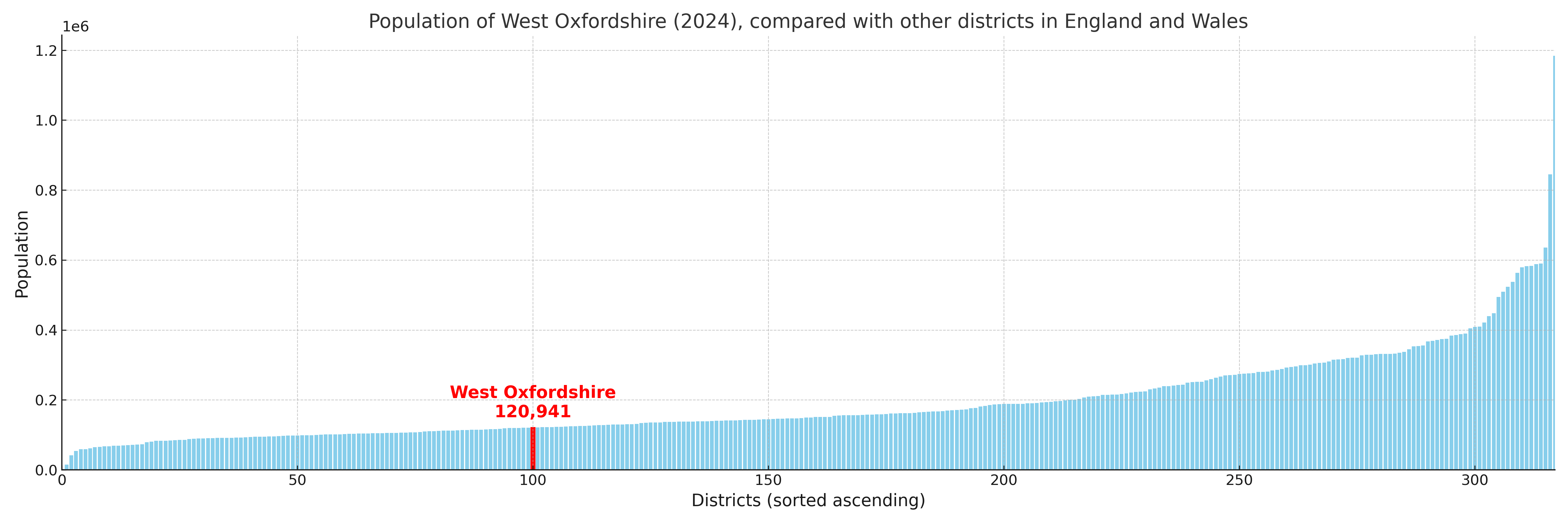
West Oxfordshire has a population of 120,941 (2024 mid-year estimate by ONS)
Population and Migration Trends in West Oxfordshire
This chart shows the population trend for West Oxfordshire from 2015 to 2024. It provides a quick overview of whether the local authority is growing, stable, or declining over time, and helps set context for the migration patterns shown below.
Population change is influenced by natural change (births minus deaths) and migration. The net migration chart below focuses on migration, separating internal migration (moves within the UK) from international migration (moves to and from abroad). Positive values indicate net inflows, while negative values indicate net outflows. The rate labels (per 1,000 residents) help compare migration intensity across years, even when the population size changes.
More local statistics and data for West Oxfordshire can be found on the ONS statistics for West Oxfordshire.
Latest news about West Oxfordshire
Use the search box, or suggested search phrases, below to find recent news, council updates, planning stories, housing developments, transport changes, public services news, local elections, community issues and other local developments related to West Oxfordshire. Results may include coverage from UK national, regional and local news websites, as well as official public-sector and local democracy sources.
- West Oxfordshire council
- West Oxfordshire planning
- West Oxfordshire local elections
- West Oxfordshire housing
- West Oxfordshire transport
- West Oxfordshire regeneration
- West Oxfordshire public services