Buckinghamshire
§ This page gives an overview of the Buckinghamshire local authority district, bringing together key facts, maps, and data to help you quickly understand the area. This is one of 361 LAD profiles on Baseview.
Overview ⁞ Buckinghamshire is a large district combining historic towns, countryside, and part of the Chiltern Hills AONB. High Wycombe is the largest town, with a historic market and theatre, while Aylesbury, Amersham, and Buckingham add local heritage. Marlow sits on the River Thames, with a famous suspension bridge and riverside walks. The Chiltern Hills provide chalk escarpments, beech woodlands, and scenic villages, while the Vale of Aylesbury offers fertile farmland and open landscapes. The mix of rivers, hills, towns, and villages defines its varied geography.
Buckinghamshire Boundary Map
This map shows the official boundary of the Buckinghamshire local authority district, based on the latest geographic data published by the Office for National Statistics (ONS). It provides a clear view of the district’s extent and helps you understand how the area fits within the wider regional and national landscape.
Contains OS data © Crown copyright and database right 2025. Source: Office for National Statistics licensed under the Open Government Licence v3.0.
The administrative boundary of Buckinghamshire can also be viewed on OpenStreetMap: District Boundary of Buckinghamshire.
Key Facts about Buckinghamshire
What region is Buckinghamshire in? Buckinghamshire is in the South East of England, a region within the UK.
What county is Buckinghamshire in? Buckinghamshire is in the county of Buckinghamshire.
Is Buckinghamshire a city? No, Buckinghamshire is not a city. (Note: the UK has 76 officially designated cities.)
Who governs Buckinghamshire? The local government for this district is: Buckinghamshire Council (Unitary Authority).
▶ Official website of Buckinghamshire Council 🔗 buckinghamshire.gov.uk
Which police force covers Buckinghamshire? Policing in Buckinghamshire is provided by Thames Valley Police 🔗 thamesvalley.police.uk, which serves 13 local authority districts: Bracknell Forest ⁞ Buckinghamshire ⁞ Cherwell ⁞ Milton Keynes ⁞ Oxford ⁞ Reading ⁞ Slough ⁞ South Oxfordshire ⁞ Vale of White Horse ⁞ West Berkshire ⁞ West Oxfordshire ⁞ Windsor and Maidenhead ⁞ Wokingham.
Buckinghamshire in International Geographies
In the International Territorial Levels (ITLs) hierarchy, Buckinghamshire is within one of ITLs Level 2 area, Berkshire, Buckinghamshire and Oxfordshire, that contains the following 5 ITLs Level 3 areas:
(ITL 1) South East
(ITL 2) ⇒ Berkshire, Buckinghamshire and Oxfordshire
(ITL 3) ⇒⇒ Milton Keynes ⁞ Buckinghamshire ⁞ Oxfordshire CC ⁞ Berkshire East ⁞ Berkshire West
The International Territorial Levels are used by OECD member countries for statistical purposes to classify administrative areas. We have this listable page for easy browsing of ITL names and codes: International Territorial Levels.
Constituencies in Buckinghamshire
Buckinghamshire is divided into 6 parliamentary constituencies, listed below in alphabetical order.
A constituency is a specific geographical area that elects one Member of Parliament (MP) to represent them in the House of Commons. The United Kingdom is divided into 650 parliamentary constituencies. We have this list page for easy browsing of all UK parliamentary constituencies: List of Constituencies.
Wards in Buckinghamshire
Buckinghamshire is divided into 49 wards, listed below in alphabetical order.
- Abbey
- Amersham and Chesham Bois
- Aston Clinton and Bierton
- Aylesbury East
- Aylesbury North
- Aylesbury North West
- Aylesbury South East
- Aylesbury South West
- Aylesbury West
- Beaconsfield
- Bernwood
- Booker, Cressex and Castlefield
- Buckingham East
- Buckingham West
- Chalfont St Giles
- Chalfont St Peter
- Chesham
- Chess Valley
- Chiltern Ridges
- Chiltern Villages
- Cliveden
- Denham
- Downley
- Farnham Common and Burnham Beeches
- Flackwell Heath, Little Marlow and Marlow South East
- Gerrards Cross
- Great Brickhill
- Great Missenden
- Grendon Underwood
- Hazlemere
- Iver
- Ivinghoe
- Little Chalfont and Amersham Common
- Marlow
- Penn Wood and Old Amersham
- Ridgeway East
- Ridgeway West
- Ryemead and Micklefield
- Stoke Poges and Wexham
- Stone and Waddesdon
- Terriers and Amersham Hill
- The Risboroughs
- The Wooburns, Bourne End and Hedsor
- Totteridge and Bowerdean
- Tylers Green and Loudwater
- Wendover, Halton and Stoke Mandeville
- West Wycombe
- Wing
- Winslow
In the UK, a ward is a subdivision of a local authority area, used mainly for electoral and statistical purposes. Defined by the ONS, wards represent the primary unit for local elections, each returning one or more councillors to the local council. Wards are also used as a key geography for presenting population and census data. We have this list page for easy browsing of all electoral wards: List of all Electoral Wards in the UK.
Parishes in Buckinghamshire
Buckinghamshire is part-parished: 171 civil parishes (listed A-Z below) alongside 1 unparished areas.
- Addington
- Adstock
- Akeley
- Amersham
- Ashendon
- Ashley Green
- Aston Abbotts
- Aston Clinton
- Aston Sandford
- Aylesbury
- Barton Hartshorn
- Beachampton
- Beaconsfield
- Berryfields
- Biddlesden
- Bierton
- Bledlow-cum-Saunderton
- Boarstall
- Bradenham
- Brill
- Broughton Hamlet
- Buckingham
- Buckingham Park
- Buckland
- Burnham
- Calvert Green
- Chalfont St Giles
- Chalfont St. Peter
- Charndon
- Chartridge
- Chearsley
- Cheddington
- Chenies
- Chepping Wycombe
- Chesham
- Chesham Bois
- Chetwode
- Chilton
- Cholesbury-cum-St Leonards
- Coldharbour
- Coleshill
- Creslow
- Cublington
- Cuddington
- Denham
- Dinton-with-Ford and Upton
- Dorney
- Dorton
- Downley
- Drayton Beauchamp
- Drayton Parslow
- Dunton
- East Claydon
- Edgcott
- Edlesborough
- Ellesborough
- Farnham Royal
- Fawley
- Fleet Marston
- Foscott
- Fulmer
- Gawcott with Lenborough
- Gerrards Cross
- Granborough
- Great and Little Hampden
- Great and Little Kimble cum Marsh
- Great Brickhill
- Great Horwood
- Great Marlow
- Great Missenden
- Grendon Underwood
- Haddenham
- Halton
- Hambleden
- Hardwick
- Hazlemere
- Hedgerley
- Hedsor
- Hillesden
- Hoggeston
- Hogshaw
- Hughenden
- Hulcott
- Ibstone
- Ickford
- Iver
- Ivinghoe
- Kingsbrook
- Kingsey
- Kingswood
- Lacey Green
- Lane End
- Latimer and Ley Hill
- Leckhampstead
- Lillingstone Dayrell with Luffield Abbey
- Lillingstone Lovell
- Little Chalfont
- Little Horwood
- Little Marlow
- Little Missenden
- Long Crendon
- Longwick-cum-Ilmer
- Ludgershall
- Maids Moreton
- Marlow
- Marlow Bottom
- Marsh Gibbon
- Marsworth
- Medmenham
- Mentmore
- Middle Claydon
- Mursley
- Nash
- Nether Winchendon
- Newton Longville
- North Marston
- Oakley
- Oving
- Padbury
- Penn
- Piddington and Wheeler End
- Pitchcott
- Pitstone
- Poundon
- Preston Bissett
- Princes Risborough
- Quainton
- Radclive-cum-Chackmore
- Radnage
- Seer Green
- Shabbington
- Shalstone
- Slapton
- Soulbury
- Steeple Claydon
- Stewkley
- Stoke Hammond
- Stoke Mandeville
- Stoke Poges
- Stokenchurch
- Stone with Bishopstone and Hartwell
- Stowe
- Swanbourne
- Taplow
- The Lee
- Thornborough
- Thornton
- Tingewick
- Turville
- Turweston
- Twyford
- Upper Winchendon
- Waddesdon
- Water Stratford
- Watermead
- Weedon
- Wendover
- West Wycombe
- Westbury
- Westcott
- Weston Turville
- Wexham
- Whaddon
- Whitchurch
- Wing
- Wingrave with Rowsham
- Winslow
- Wooburn
- Woodham
- Worminghall
- Wotton Underwood
A civil parish is the lowest tier of local government in England, used for villages, small towns, and suburbs. They have their own local authority, either a parish council or a parish meeting, which provides local services like managing parks, allotments, and streetlights, and represents the community's views to larger councils.
We have this list page for easy browsing of all parishes: List of Civil Parishes in England and Wales.
Post Towns in Buckinghamshire
Below is a list of post towns in Buckinghamshire, grouped by postcode area:
- HP ▸ Amersham (HP6 / HP7) ⁞ Aylesbury (HP17 / HP18 / HP19 / HP20 / HP21 / HP22) ⁞ Beaconsfield (HP9) ⁞ Chalfont St. Giles (HP8) ⁞ Chesham (HP5) ⁞ Great Missenden (HP16) ⁞ High Wycombe (HP10 / HP11 / HP12 / HP13 / HP14 / HP15) ⁞ Princes Risborough (HP22 / HP27)
- MK ▸ Buckingham (MK18)
- SL ▸ Bourne End (SL8) ⁞ Gerrards Cross (SL9) ⁞ Iver (SL0) ⁞ Marlow (SL7)
The UK postal hierarchy begins with broad postcode areas (such as “CB” or “M”), which are divided into smaller postcode districts (such as “CB8” or “M1”) to support accurate mail routing. Each postal address is anchored by a designated post town, the official locality name used in the UK postcode system, which operates independently from Local Authority Districts —the administrative boundaries used for council tax and local government services. Because they serve different purposes, a property’s postal address and its local authority district do not always align exactly.
Built-up Areas in Buckinghamshire
Buckinghamshire covers 156 built-up areas, listed below in alphabetical order.
- Akeley
- Amersham
- Ashley Green
- Askett and Whiteleaf
- Aston Abbotts
- Aston Clinton
- Aylesbury
- Baker's Wood
- Ballinger Common
- Barton Hartshorn
- Beacon's Bottom
- Beaconsfield
- Bierton
- Bishopstone (Buckinghamshire)
- Bledlow Ridge
- Bletchley *
- Bolter End
- Bourne End *
- Bovingdon Green
- Bray *
- Brill
- Broughton (Buckinghamshire)
- Buckingham
- Butler's Cross
- Calvert
- Chalfont St Giles
- Chalfont St Peter
- Chartridge
- Chearsley
- Cheddington
- Chesham
- Cholesbury *
- Chorleywood *
- Clayhill
- Coleshill (Buckinghamshire)
- Cookham *
- Cryers Hill
- Cublington
- Cuddington (Buckinghamshire)
- Dadford
- Dagnall
- Denham
- Dinton (Buckinghamshire)
- Dorney Reach *
- Dorton
- Downley
- Drayton Parslow
- Eaton Bray and Edlesborough *
- Edgcott
- Eton Wick *
- Farnham Common and Farnham Royal *
- Fawley
- Finmere *
- Flackwell Heath and Wooburn Green
- Fleet Marston
- Frieth
- Fulmer
- Gawcott
- George Green
- Gerrards Cross
- Granborough
- Great Brickhill
- Great Horwood
- Great Kimble
- Great Kingshill
- Greenlands
- Grendon Underwood
- Haddenham (Buckinghamshire)
- Halton (Buckinghamshire)
- Hazlemere
- High Wycombe
- Higher Denham
- Hillingdon *
- Hughenden Valley
- Hurley (Windsor and Maidenhead) *
- Hyde Heath
- Ickford
- Iver
- Iver Heath
- Lacey Green and Loosley Row
- Lane End
- Lee Common
- Leighton Buzzard *
- Ley Hill
- Little Chalfont
- Little Gaddesden *
- Little Kimble
- Little Kingshill
- Little Missenden
- Long Crendon
- Longwick
- Ludgershall (Buckinghamshire)
- Lye Green
- Maidenhead *
- Maids Moreton
- Marlow *
- Marlow Bottom
- Marsh Gibbon
- Marsworth
- Milton Keynes *
- Mundaydean Bottom
- Mursley
- Nash
- New Denham *
- Newton Longville
- Newton Purcell *
- North Marston
- Oakley (Buckinghamshire)
- Oving
- Padbury
- Pitstone
- Prestwood and Great Missenden
- Princes Risborough
- Quainton
- Richings Park
- Seer Green
- Shabbington
- Shipton Lee
- Silverstone *
- Slapton (Buckinghamshire)
- Slough *
- Soulbury
- South Heath
- Speen
- Steeple Claydon
- Stewkley
- Stoke Hammond
- Stoke Mandeville
- Stoke Poges
- Stokenchurch
- Stone (Buckinghamshire)
- Swanbourne
- Taplow
- Tatling End
- The City
- Thornborough
- Tingewick
- Turweston *
- Twyford (Buckinghamshire)
- Waddesdon
- Walter's Ash and Naphill
- Weedon
- Wendover
- West Hyde *
- Westbury (Buckinghamshire) *
- Westcott (Buckinghamshire)
- Weston Turville
- Wexham Street
- Whaddon (Buckinghamshire)
- Whitchurch (Buckinghamshire)
- Whitfield (Buckinghamshire)
- Winchmore Hill
- Wing (Buckinghamshire)
- Wingrave
- Winslow
- Worminghall *
In the UK, a Built-up Area (BUA) is a continuous urban area of at least 20 hectares (0.2 km²), defined by the ONS as land where buildings are generally no more than 200 metres apart, such as towns, cities, or large villages. (Note: A BUA name marked with an asterisk (*) indicates that the area is situated partly in the district of Buckinghamshire.)
We have this list page for easy browsing of all built-up areas: List of all Built-up Areas in GB.
Railway Stations in Buckinghamshire
Buckinghamshire is served by a number of National Rail stations, providing rail connections to nearby towns, cities, and destinations across Great Britain. The railway stations listed below are located within the Buckinghamshire Local Authority District and are grouped by train operating company for clarity.
- Chiltern Railways ▸ High Wycombe (HP13 6NN) ⁞ Beaconsfield (HP9 2PJ) ⁞ Gerrards Cross (SL9 8PP) ⁞ Aylesbury (HP20 1RU) ⁞ Haddenham and Thame Parkway (HP17 8EP) ⁞ Princes Risborough (HP27 9DN) ⁞ Great Missenden (HP16 9AZ) ⁞ Wendover (HP22 6BN) ⁞ Denham (UB9 5ES) ⁞ Stoke Mandeville (HP22 5UA) ⁞ Aylesbury Vale Parkway (HP18 0PS) ⁞ Seer Green (HP9 2UT) ⁞ Saunderton (HP14 4LJ) ⁞ Denham Golf Club (UB9 5EJ) ⁞ Monks Risborough (HP27 9JQ) ⁞ Little Kimble (HP17 0XP)
- Great Western Railway ▸ Marlow (SL7 1NT) ⁞ Bourne End (SL8 5QH)
- London Underground ▸ Amersham (HP6 5AZ) ⁞ Chalfont and Latimer (HP7 9PR)
- TfL Rail ▸ Taplow (SL6 0NU) ⁞ Iver (SL0 9AU)
- West Midlands Trains (London Northwestern Railway) ▸ Cheddington (LU7 0SQ)
This is a district-level view only. For a complete list of all National Rail stations across Great Britain, see the UK National Rail Stations Directory.
Buckinghamshire compared with other districts in the UK
This section shows how Buckinghamshire compares with other local authority districts in the UK, using a variety of measures and rankings.
Buckinghamshire has 49 electoral wards.

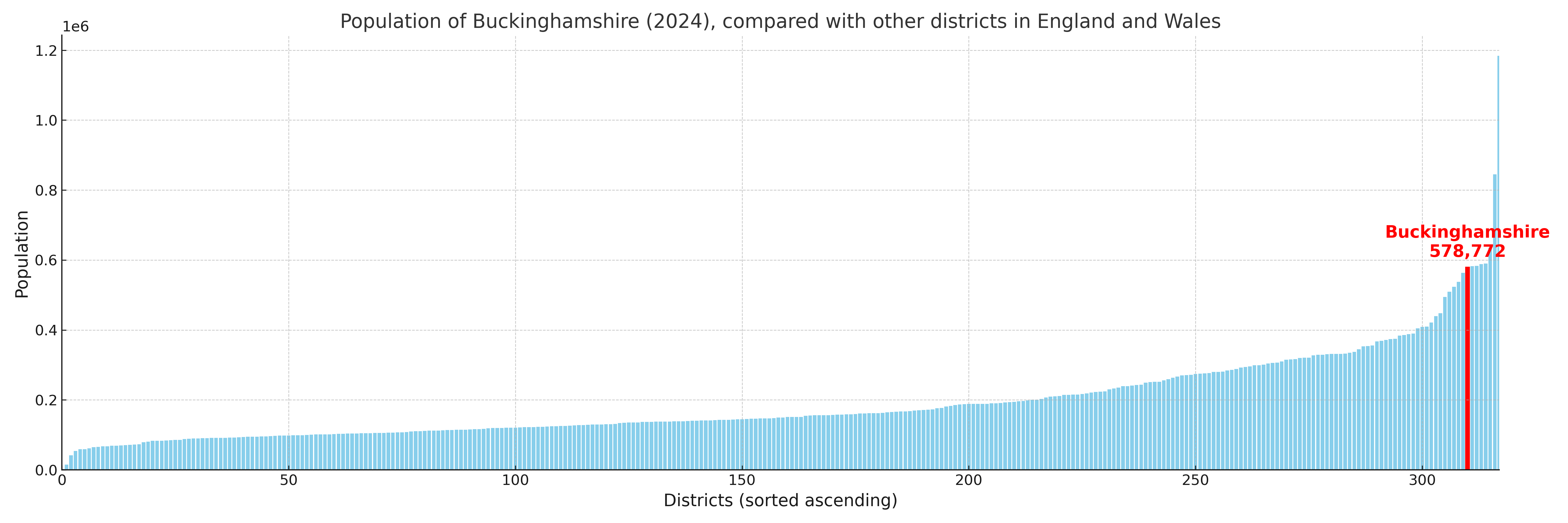
Buckinghamshire has a population of 578,772 (2024 mid-year estimate by ONS)
Population and Migration Trends in Buckinghamshire
This chart shows the population trend for Buckinghamshire from 2015 to 2024. It provides a quick overview of whether the local authority is growing, stable, or declining over time, and helps set context for the migration patterns shown below.
Population change is influenced by natural change (births minus deaths) and migration. The net migration chart below focuses on migration, separating internal migration (moves within the UK) from international migration (moves to and from abroad). Positive values indicate net inflows, while negative values indicate net outflows. The rate labels (per 1,000 residents) help compare migration intensity across years, even when the population size changes.
More local statistics and data for Buckinghamshire can be found on the ONS statistics for Buckinghamshire.
Latest news about Buckinghamshire
Use the search box, or suggested search phrases, below to find recent news, council updates, planning stories, housing developments, transport changes, public services news, local elections, community issues and other local developments related to Buckinghamshire. Results may include coverage from UK national, regional and local news websites, as well as official public-sector and local democracy sources.
- Buckinghamshire council
- Buckinghamshire planning
- Buckinghamshire local elections
- Buckinghamshire housing
- Buckinghamshire transport
- Buckinghamshire regeneration
- Buckinghamshire public services