Cherwell
§ This page gives an overview of the Cherwell local authority district, bringing together key facts, maps, and data to help you quickly understand the area. This is one of 361 LAD profiles on Baseview.
Overview ⁞ Cherwell, in north Oxfordshire, covers a wide landscape of market towns, villages, and countryside. Banbury is the main town, with a canal, museum, and historic market square, while Bicester is known for its shopping village and Roman heritage. Kidlington, near Oxford, is a large village with green spaces and river meadows. The Oxford Canal and River Cherwell run through, alongside farmland, rolling hills, and historic estates such as Rousham House. Its landscape is defined by waterways, villages, and traditional market towns.
Cherwell Boundary Map
This map shows the official boundary of the Cherwell local authority district, based on the latest geographic data published by the Office for National Statistics (ONS). It provides a clear view of the district’s extent and helps you understand how the area fits within the wider regional and national landscape.
Contains OS data © Crown copyright and database right 2025. Source: Office for National Statistics licensed under the Open Government Licence v3.0.
The administrative boundary of Cherwell can also be viewed on OpenStreetMap: District Boundary of Cherwell.
Key Facts about Cherwell
What region is Cherwell in? Cherwell is in the South East of England, a region within the UK.
What county is Cherwell in? Cherwell is located in the county of Oxfordshire.
Is Cherwell a city? No, Cherwell is not a city. (Note: the UK has 76 officially designated cities.)
Who governs Cherwell? The local authority for this district is: Cherwell District Council - responsible for district-level services. Since Oxfordshire is a two-tier area, county-level services are handled by: Oxfordshire County Council.
▶ Official website of Cherwell District Council 🔗 cherwell.gov.uk

Which police force covers Cherwell? Policing in Cherwell is provided by Thames Valley Police 🔗 thamesvalley.police.uk, which serves 13 local authority districts: Bracknell Forest ⁞ Buckinghamshire ⁞ Cherwell ⁞ Milton Keynes ⁞ Oxford ⁞ Reading ⁞ Slough ⁞ South Oxfordshire ⁞ Vale of White Horse ⁞ West Berkshire ⁞ West Oxfordshire ⁞ Windsor and Maidenhead ⁞ Wokingham.
Constituencies in Cherwell
Cherwell is divided into 2 parliamentary constituencies, listed below in alphabetical order.
A constituency is a specific geographical area that elects one Member of Parliament (MP) to represent them in the House of Commons. The United Kingdom is divided into 650 parliamentary constituencies. We have this list page for easy browsing of all UK parliamentary constituencies: List of Constituencies.
Wards in Cherwell
Cherwell is divided into 16 wards, listed below in alphabetical order.
- Adderbury, Bloxham and Bodicote
- Banbury Calthorpe and Easington
- Banbury Cross and Neithrop
- Banbury Grimsbury and Hightown
- Banbury Hardwick
- Banbury Ruscote
- Bicester East
- Bicester North and Caversfield
- Bicester South and Ambrosden
- Bicester West
- Cropredy, Sibfords and Wroxton
- Deddington
- Fringford and Heyfords
- Kidlington East
- Kidlington West
- Launton and Otmoor
In the UK, a ward is a subdivision of a local authority area, used mainly for electoral and statistical purposes. Defined by the ONS, wards represent the primary unit for local elections, each returning one or more councillors to the local council. Wards are also used as a key geography for presenting population and census data. We have this list page for easy browsing of all electoral wards: List of all Electoral Wards in the UK.
Parishes in Cherwell
Cherwell is fully parished: 79 civil parishes, listed A-Z below.
- Adderbury
- Ambrosden
- Ardley
- Arncott
- Banbury
- Barford St. John and St. Michael
- Begbroke
- Bicester
- Blackthorn
- Bletchingdon
- Bloxham
- Bodicote
- Bourton
- Broughton
- Bucknell
- Caversfield
- Charlton-on-Otmoor
- Chesterton
- Claydon with Clattercot
- Cottisford
- Cropredy
- Deddington
- Drayton
- Duns Tew
- Epwell
- Fencott and Murcott
- Finmere
- Fringford
- Fritwell
- Godington
- Gosford and Water Eaton
- Hampton Gay and Poyle
- Hanwell
- Hardwick with Tusmore
- Hethe
- Heyford Park
- Hook Norton
- Horley
- Hornton
- Horton-cum-Studley
- Islip
- Kidlington
- Kirtlington
- Launton
- Lower Heyford
- Merton
- Middle Aston
- Middleton Stoney
- Milcombe
- Milton
- Mixbury
- Mollington
- Newton Purcell with Shelswell
- Noke
- North Aston
- North Newington
- Oddington
- Piddington
- Prescote
- Shenington with Alkerton
- Shipton-on-Cherwell and Thrupp
- Shutford
- Sibford Ferris
- Sibford Gower
- Somerton
- Souldern
- South Newington
- Steeple Aston
- Stoke Lyne
- Stratton Audley
- Swalcliffe
- Tadmarton
- Upper Heyford
- Wardington
- Wendlebury
- Weston-on-the-Green
- Wigginton
- Wroxton
- Yarnton
A civil parish is the lowest tier of local government in England, used for villages, small towns, and suburbs. They have their own local authority, either a parish council or a parish meeting, which provides local services like managing parks, allotments, and streetlights, and represents the community's views to larger councils.
We have this list page for easy browsing of all parishes: List of Civil Parishes in England and Wales.
Post Towns in Cherwell
Below is a list of post towns in Cherwell, grouped by postcode area:
- OX ▸ Banbury (OX15 / OX16 / OX17) ⁞ Bicester (OX25 / OX26 / OX27) ⁞ Kidlington (OX5)
The UK postal hierarchy begins with broad postcode areas (such as “CB” or “M”), which are divided into smaller postcode districts (such as “CB8” or “M1”) to support accurate mail routing. Each postal address is anchored by a designated post town, the official locality name used in the UK postcode system, which operates independently from Local Authority Districts —the administrative boundaries used for council tax and local government services. Because they serve different purposes, a property’s postal address and its local authority district do not always align exactly.
Built-up Areas in Cherwell
Cherwell covers 57 built-up areas, listed below in alphabetical order.
- Adderbury and Twyford
- Ambrosden
- Ardley and Fewcott
- Banbury *
- Barford St John
- Barford St Michael
- Begbroke
- Bicester
- Blackthorn
- Bladon *
- Bletchingdon
- Bloxham
- Bodicote
- Broughton (Cherwell)
- Bucknell (Cherwell)
- Chacombe *
- Charlton-on-Otmoor
- Chesterton
- Cropredy
- Deddington
- Duns Tew
- Finmere *
- Fringford
- Fritwell
- Great Bourton
- Hook Norton
- Horley (Cherwell)
- Hornton
- Horton-cum-Studley
- Islip (Cherwell)
- Kidlington
- Kirtlington
- Launton
- Lower Heyford
- Milcombe
- Mixbury
- Mollington (Cherwell)
- Newton Purcell *
- North Aston
- Oxford *
- Piddington (Cherwell)
- Shenington
- Sibford Ferris
- Sibford Gower
- South Newington
- Steeple Aston
- Stratton Audley
- Swalcliffe
- Upper Arncott
- Upper Heyford
- Wardington
- Wendlebury
- Westbury (Buckinghamshire) *
- Weston-on-the-Green
- Woodstock *
- Wroxton
- Yarnton
In the UK, a Built-up Area (BUA) is a continuous urban area of at least 20 hectares (0.2 km²), defined by the ONS as land where buildings are generally no more than 200 metres apart, such as towns, cities, or large villages. (Note: A BUA name marked with an asterisk (*) indicates that the area is situated partly in the district of Cherwell.)
We have this list page for easy browsing of all built-up areas: List of all Built-up Areas in GB.
Railway Stations in Cherwell
Cherwell is served by a number of National Rail stations, providing rail connections to nearby towns, cities, and destinations across Great Britain. The railway stations listed below are located within the Cherwell Local Authority District and are grouped by train operating company for clarity.
- Chiltern Railways ▸ Banbury (OX16 5AB) ⁞ Bicester Village (OX26 6HU) ⁞ Bicester North (OX26 6EF) ⁞ Oxford Parkway (OX2 8HA) ⁞ Islip (OX5 2TQ)
- Great Western Railway ▸ Heyford (OX6 8UL)
This is a district-level view only. For a complete list of all National Rail stations across Great Britain, see the UK National Rail Stations Directory.
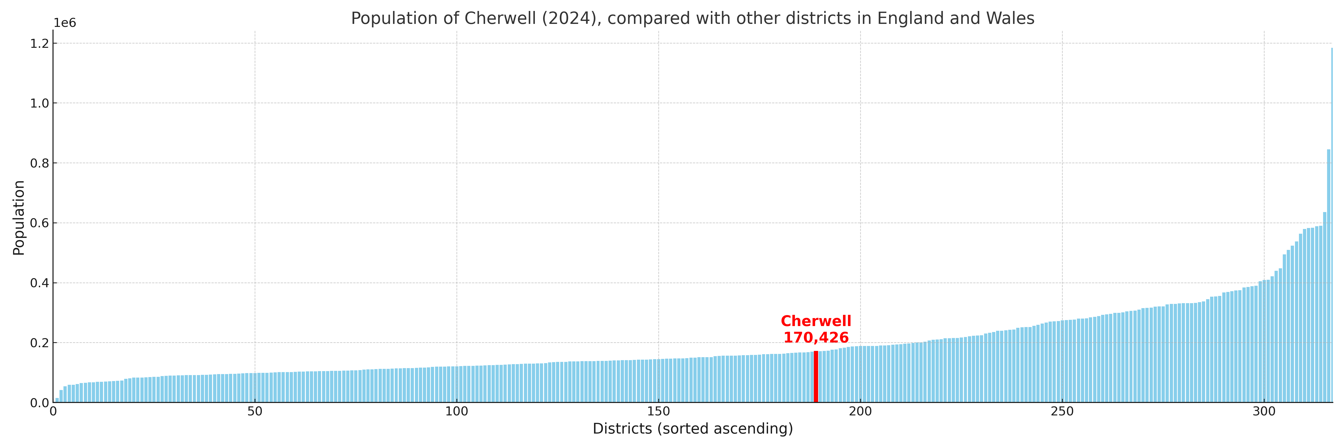
Cherwell compared with other districts in the UK
This section shows how Cherwell compares with other local authority districts in the UK, using a variety of measures and rankings.
Cherwell has 16 electoral wards.

Cherwell has a population of 170,426 (2024 mid-year estimate by ONS)
Population and Migration Trends in Cherwell
This chart shows the population trend for Cherwell from 2015 to 2024. It provides a quick overview of whether the local authority is growing, stable, or declining over time, and helps set context for the migration patterns shown below.
Population change is influenced by natural change (births minus deaths) and migration. The net migration chart below focuses on migration, separating internal migration (moves within the UK) from international migration (moves to and from abroad). Positive values indicate net inflows, while negative values indicate net outflows. The rate labels (per 1,000 residents) help compare migration intensity across years, even when the population size changes.
More local statistics and data for Cherwell can be found on the ONS statistics for Cherwell.
Latest news about Cherwell
Use the search box, or suggested search phrases, below to find recent news, council updates, planning stories, housing developments, transport changes, public services news, local elections, community issues and other local developments related to Cherwell. Results may include coverage from UK national, regional and local news websites, as well as official public-sector and local democracy sources.
- Cherwell council
- Cherwell planning
- Cherwell local elections
- Cherwell housing
- Cherwell transport
- Cherwell regeneration
- Cherwell public services