West Berkshire
§ This page gives an overview of the West Berkshire local authority district, bringing together key facts, maps, and data to help you quickly understand the area. This is one of 361 LAD profiles on Baseview.
Overview ⁞ West Berkshire is a largely rural district stretching across the North Wessex Downs AONB, with rolling chalk hills, woodlands, and river valleys. Newbury is the main town, with its racecourse, canal, and historic streets, while Hungerford and Thatcham add market town character. The River Kennet and Kennet and Avon Canal run through, alongside farmland, meadows, and estates. Villages with historic cottages and churches dot the countryside, creating a mix of scenic landscapes and traditional settlements.
West Berkshire Boundary Map
This map shows the official boundary of the West Berkshire local authority district, based on the latest geographic data published by the Office for National Statistics (ONS). It provides a clear view of the district’s extent and helps you understand how the area fits within the wider regional and national landscape.
Contains OS data © Crown copyright and database right 2025. Source: Office for National Statistics licensed under the Open Government Licence v3.0.
The administrative boundary of West Berkshire can also be viewed on OpenStreetMap: District Boundary of West Berkshire.
Key Facts about West Berkshire
What region is West Berkshire in? West Berkshire is in the South East of England, a region within the UK.
What county is West Berkshire in? West Berkshire is in the county of Berkshire.
Is West Berkshire a city? No, West Berkshire is not a city. (Note: the UK has 76 officially designated cities.)
Who governs West Berkshire? The local government for this district is: West Berkshire Council (Unitary Authority).
▶ Official website of West Berkshire Council 🔗 westberks.gov.uk

Which police force covers West Berkshire? Policing in West Berkshire is provided by Thames Valley Police 🔗 thamesvalley.police.uk, which serves 13 local authority districts: Bracknell Forest ⁞ Buckinghamshire ⁞ Cherwell ⁞ Milton Keynes ⁞ Oxford ⁞ Reading ⁞ Slough ⁞ South Oxfordshire ⁞ Vale of White Horse ⁞ West Berkshire ⁞ West Oxfordshire ⁞ Windsor and Maidenhead ⁞ Wokingham.
Constituencies in West Berkshire
West Berkshire is divided into 2 parliamentary constituencies, listed below in alphabetical order.
A constituency is a specific geographical area that elects one Member of Parliament (MP) to represent them in the House of Commons. The United Kingdom is divided into 650 parliamentary constituencies. We have this list page for easy browsing of all UK parliamentary constituencies: List of Constituencies.
Wards in West Berkshire
West Berkshire is divided into 24 wards, listed below in alphabetical order.
- Aldermaston
- Basildon
- Bradfield
- Bucklebury
- Burghfield & Mortimer
- Chieveley & Cold Ash
- Downlands
- Hungerford & Kintbury
- Lambourn
- Newbury Central
- Newbury Clay Hill
- Newbury Greenham
- Newbury Speen
- Newbury Wash Common
- Pangbourne
- Ridgeway
- Thatcham Central
- Thatcham Colthrop & Crookham
- Thatcham North East
- Thatcham West
- Theale
- Tilehurst & Purley
- Tilehurst Birch Copse
- Tilehurst South & Holybrook
In the UK, a ward is a subdivision of a local authority area, used mainly for electoral and statistical purposes. Defined by the ONS, wards represent the primary unit for local elections, each returning one or more councillors to the local council. Wards are also used as a key geography for presenting population and census data. We have this list page for easy browsing of all electoral wards: List of all Electoral Wards in the UK.
Parishes in West Berkshire
West Berkshire is fully parished: 63 civil parishes, listed A-Z below.
- Aldermaston
- Aldworth
- Ashampstead
- Basildon
- Beech Hill
- Beedon
- Beenham
- Boxford
- Bradfield
- Brightwalton
- Brimpton
- Bucklebury
- Burghfield
- Catmore
- Chaddleworth
- Chieveley
- Cold Ash
- Combe
- Compton
- East Garston
- East Ilsley
- Enborne
- Englefield
- Farnborough
- Fawley
- Frilsham
- Great Shefford
- Greenham
- Hampstead Marshall
- Hampstead Norreys
- Hermitage
- Holybrook
- Hungerford
- Inkpen
- Kintbury
- Lambourn
- Leckhampstead
- Midgham
- Newbury
- Padworth
- Pangbourne
- Peasemore
- Purley on Thames
- Shaw cum Donnington
- Speen
- Stanford Dingley
- Stratfield Mortimer
- Streatley
- Sulham
- Sulhamstead
- Thatcham
- Theale
- Tidmarsh
- Tilehurst
- Ufton Nervet
- Wasing
- Welford
- West Ilsley
- West Woodhay
- Winterbourne
- Wokefield
- Woolhampton
- Yattendon
A civil parish is the lowest tier of local government in England, used for villages, small towns, and suburbs. They have their own local authority, either a parish council or a parish meeting, which provides local services like managing parks, allotments, and streetlights, and represents the community's views to larger councils.
We have this list page for easy browsing of all parishes: List of Civil Parishes in England and Wales.
Post Towns in West Berkshire
Below is a list of post towns in West Berkshire, grouped by postcode area:
- RG ▸ Hungerford (RG17) ⁞ Newbury (RG14 / RG20) ⁞ Thatcham (RG18 / RG19)
The UK postal hierarchy begins with broad postcode areas (such as “CB” or “M”), which are divided into smaller postcode districts (such as “CB8” or “M1”) to support accurate mail routing. Each postal address is anchored by a designated post town, the official locality name used in the UK postcode system, which operates independently from Local Authority Districts —the administrative boundaries used for council tax and local government services. Because they serve different purposes, a property’s postal address and its local authority district do not always align exactly.
Built-up Areas in West Berkshire
West Berkshire covers 55 built-up areas, listed below in alphabetical order.
- Aldermaston
- Aldermaston Wharf
- Ashmore Green
- Ball Hill *
- Beenham
- Bishop's Green
- Boxford (West Berkshire)
- Bradfield (West Berkshire)
- Brimpton
- Brimpton Common *
- Burghfield
- Burghfield Common
- Chaddleworth
- Chapel Row
- Chieveley
- Cold Ash
- Compton (West Berkshire)
- Curridge
- East Garston
- East Ilsley
- Eastbury
- Goring *
- Grazeley Green
- Great Shefford
- Greenham
- Hampstead Norreys
- Hermitage
- Hungerford
- Inkpen
- Kintbury
- Lambourn
- Lambourn Woodlands
- Lower Basildon
- Lower Green
- Lower Padworth
- Mortimer *
- Newbury
- Old Warren *
- Pangbourne *
- Peasemore
- Reading *
- Southend
- Stanford Dingley
- Stratfield Mortimer
- Streatley (West Berkshire) *
- Tadley *
- Thatcham
- Theale (West Berkshire)
- Tidmarsh
- Tutts Clump
- Upper Basildon
- Upper Bucklebury
- Upper Lambourn
- Welford (West Berkshire)
- Woolhampton
In the UK, a Built-up Area (BUA) is a continuous urban area of at least 20 hectares (0.2 km²), defined by the ONS as land where buildings are generally no more than 200 metres apart, such as towns, cities, or large villages. (Note: A BUA name marked with an asterisk (*) indicates that the area is situated partly in the district of West Berkshire.)
We have this list page for easy browsing of all built-up areas: List of all Built-up Areas in GB.
Railway Stations in West Berkshire
West Berkshire is served by a number of National Rail stations, providing rail connections to nearby towns, cities, and destinations across Great Britain. The railway stations listed below are located within the West Berkshire Local Authority District and are grouped by train operating company for clarity.
- Great Western Railway ▸ Newbury (RG14 5DG) ⁞ Thatcham (RG19 4PP) ⁞ Theale (RG7 4AA) ⁞ Pangbourne (RG8 7DY) ⁞ Hungerford (RG17 0DY) ⁞ Mortimer (RG7 3NY) ⁞ Newbury Racecourse (RG14 5ST) ⁞ Kintbury (RG17 9UT) ⁞ Aldermaston (RG7 4LB) ⁞ Midgham (RG7 5SE)
This is a district-level view only. For a complete list of all National Rail stations across Great Britain, see the UK National Rail Stations Directory.
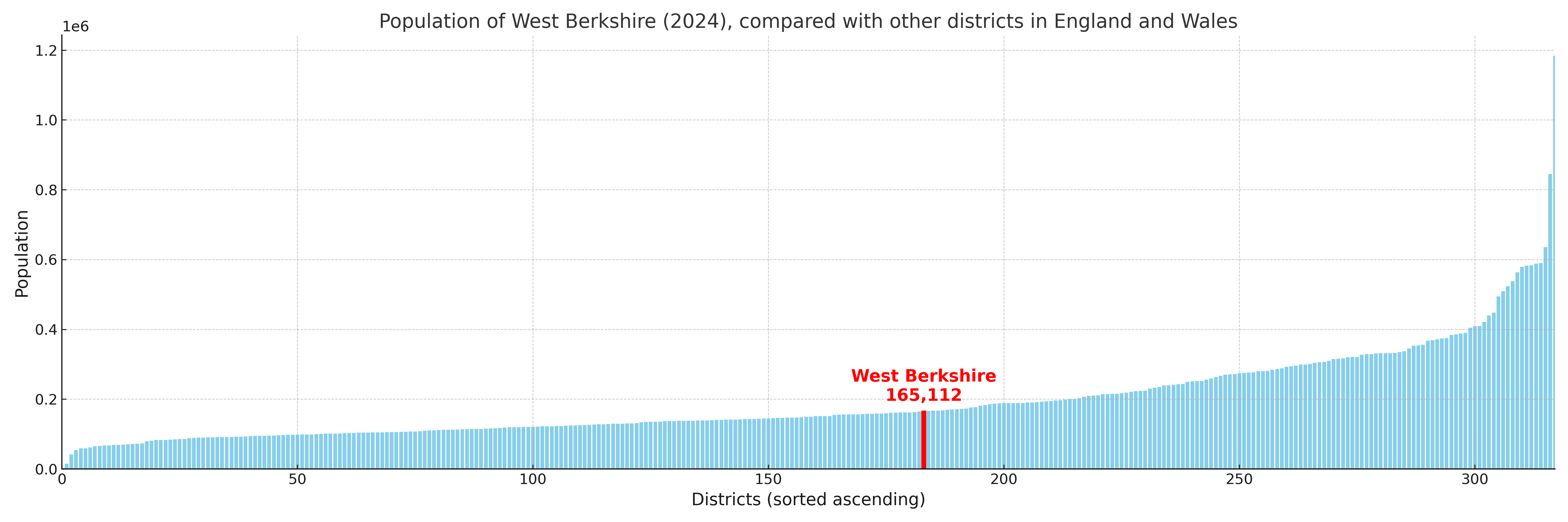
West Berkshire compared with other districts in the UK
This section shows how West Berkshire compares with other local authority districts in the UK, using a variety of measures and rankings.
West Berkshire has 24 electoral wards.

West Berkshire has a population of 165,112 (2024 mid-year estimate by ONS)
Population and Migration Trends in West Berkshire
This chart shows the population trend for West Berkshire from 2015 to 2024. It provides a quick overview of whether the local authority is growing, stable, or declining over time, and helps set context for the migration patterns shown below.
Population change is influenced by natural change (births minus deaths) and migration. The net migration chart below focuses on migration, separating internal migration (moves within the UK) from international migration (moves to and from abroad). Positive values indicate net inflows, while negative values indicate net outflows. The rate labels (per 1,000 residents) help compare migration intensity across years, even when the population size changes.
More local statistics and data for West Berkshire can be found on the ONS statistics for West Berkshire.
Latest news about West Berkshire
Use the search box, or suggested search phrases, below to find recent news, council updates, planning stories, housing developments, transport changes, public services news, local elections, community issues and other local developments related to West Berkshire. Results may include coverage from UK national, regional and local news websites, as well as official public-sector and local democracy sources.
- West Berkshire council
- West Berkshire planning
- West Berkshire local elections
- West Berkshire housing
- West Berkshire transport
- West Berkshire regeneration
- West Berkshire public services