Northern Ireland
§ This page provides an overview of UK's Northern Ireland region, with key facts and data. Last updated on .
Overview ⁞ Located on the island of Ireland, Northern Ireland is the only part of the UK with a land border — shared with the Republic of Ireland. It is known for its striking scenery, including the Giant’s Causeway, Mourne Mountains, and scenic loughs, as well as its vibrant capital city Belfast. The region’s identity reflects a unique mix of British and Irish heritage, shaped by a complex political history including The Troubles.
Northern Ireland is both a region and a country of the UK. It comprises six historic counties — Antrim, Armagh, Down, Fermanagh, Londonderry, and Tyrone — but is governed through 11 modern local government districts. The Northern Ireland Assembly in Belfast has devolved powers over education, health, justice, and other key services. Urban centres such as Belfast and Derry/Londonderry sit close to rural landscapes of farmland, mountains, and coastline, making the region compact yet geographically diverse.
Local Government Districts in Northern Ireland
Northern Ireland’s 11 local government districts, established in 2015 by merging 26 former councils, are single-tier authorities responsible for services such as planning, waste management, leisure facilities, and community development.
- Antrim and Newtownabbey
- Ards and North Down
- Armagh City, Banbridge and Craigavon
- Belfast
- Causeway Coast and Glens
- Derry City and Strabane
- Fermanagh and Omagh
- Lisburn and Castlereagh
- Mid and East Antrim
- Mid Ulster
- Newry, Mourne and Down
Cities in Northern Ireland
Northern Ireland is home to several officially designated cities, each holding city status by royal charter rather than population size alone. Below is a complete list of cities in the region, including their local authorities, administrative geography, ceremonial honours, and the year city status was granted.
Londonderry
- City within
- Derry City and Strabane (local government district)
- Civic honour
- No additional civic honour
- City status granted
- 1604
Belfast
- Local government district
- Belfast (Unitary authority)
- Civic honour
- Lord Mayor
- City status granted
- 1888
Armagh
- City within
- Armagh City, Banbridge and Craigavon (local government district)
- Civic honour
- Lord Mayor
- City status granted
- 1994
Lisburn
- City within
- Lisburn and Castlereagh (local government district)
- Civic honour
- No additional civic honour
- City status granted
- 2002
Newry
- City within
- Newry, Mourne and Down (local government district)
- Civic honour
- No additional civic honour
- City status granted
- 2002
Bangor
- City within
- Ards and North Down (local government district)
- Civic honour
- No additional civic honour
- City status granted
- 2022
Post Towns in Northern Ireland
Below is a complete list of post towns in Northern Ireland, grouped by postcode area to make browsing easier.
- BT ▸ Antrim ⁞ Armagh ⁞ Augher ⁞ Aughnacloy ⁞ Ballycastle ⁞ Ballyclare ⁞ Ballymena ⁞ Ballymoney ⁞ Ballynahinch ⁞ Banbridge ⁞ Bangor ⁞ Belfast ⁞ Bushmills ⁞ Caledon ⁞ Carrickfergus ⁞ Castlederg ⁞ Castlewellan ⁞ Clogher ⁞ Coleraine ⁞ Cookstown ⁞ Craigavon ⁞ Crumlin ⁞ Donaghadee ⁞ Downpatrick ⁞ Dromore ⁞ Dungannon ⁞ Enniskillen ⁞ Fivemiletown ⁞ Hillsborough ⁞ Holywood ⁞ Larne ⁞ Limavady ⁞ Lisburn ⁞ Londonderry ⁞ Maghera ⁞ Magherafelt ⁞ Newcastle ⁞ Newry ⁞ Newtownabbey ⁞ Newtownards ⁞ Omagh ⁞ Portrush ⁞ Portstewart ⁞ Strabane
International Territorial Levels in Northern Ireland Region
The International Territorial Levels (ITLs) are a hierarchical system of geographic boundaries used for statistical purposes, specifically for regional data analysis and international comparisons. It has three levels: ITL1, ITL2, and ITL3, with ITL1 being the broadest level and ITL3 the most detailed.
Northern Ireland Region is one of ITL 1 areas in the UK. It is then divided ino the following ITL 2 areas (names in bold letters) and ITL 3 areas.
- Northern Ireland — Belfast ⁞ Armagh City, Banbridge and Craigavon ⁞ Newry, Mourne and Down ⁞ Ards and North Down ⁞ Derry City and Strabane ⁞ Mid Ulster ⁞ Causeway Coast and Glens ⁞ Antrim and Newtownabbey ⁞ Lisburn and Castlereagh ⁞ Mid and East Antrim ⁞ Fermanagh and Omagh
Constituencies in Northern Ireland
The region has 18 parliamentary constituencies, spanning urban, suburban, and rural areas across all six historic counties. From Belfast’s densely populated city seats to the rural constituencies of Fermanagh and Tyrone, the political landscape is distinct from the rest of the UK. Representation is dominated by Northern Ireland–based parties including the Democratic Unionist Party (DUP), Sinn Féin, Social Democratic and Labour Party (SDLP), Ulster Unionist Party (UUP), and the cross-community Alliance Party.
- Belfast East
- Belfast North
- Belfast South and Mid Down
- Belfast West
- East Antrim
- East Londonderry
- Fermanagh and South Tyrone
- Foyle
- Lagan Valley
- Mid Ulster
- Newry and Armagh
- North Antrim
- North Down
- South Antrim
- South Down
- Strangford
- Upper Bann
- West Tyrone
Population of Northern Ireland
Northern Ireland is home to approximately 1.91 million people as of mid-2022. Covering around 13,550 square kilometres, the region has a population density of about 141 people per square kilometre.
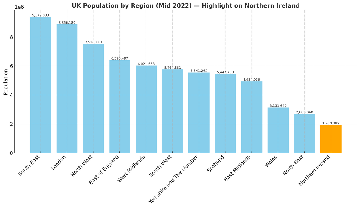
How it compares to the rest of the UK
- Share of the population: Northern Ireland accounts for roughly 2.8% of the UK’s total population of 67.6 million.
- Population density: At 141 people per km², Northern Ireland is much less crowded than England’s average of 438 per km², and notably closer to densities seen in countries such as Denmark or the Czech Republic.