East Midlands
§ This page provides an overview of UK's East Midlands region, with key facts and data. Last updated on .
Overview ⁞ The East Midlands is a central region of England that blends rural landscapes, historic towns, and thriving cities. It is home to the Peak District National Park and the Lincolnshire Wolds, offering hiking, cycling, and scenic views. The region has a rich industrial heritage in manufacturing, textiles, and engineering, alongside strong agricultural traditions. Cultural icons include the Robin Hood legend and medieval architecture in cities such as Nottingham, Leicester, and Derby.
The region features a mix of administrative structures, with major cities like Nottingham and Leicester operating as unitary authorities, while surrounding counties retain two-tier systems. Historic county lines remain influential, but local government reforms have created independent authorities in some urban areas. This structure supports the varied needs of urban centres, commuter towns, and rural communities.
Ceremonial Counties in East Midlands region
The East Midlands consists of six ceremonial counties: Derbyshire, Leicestershire, Lincolnshire, Northamptonshire, Nottinghamshire, and Rutland. Highlights range from industrial hubs and university cities to market towns and rural landscapes. The region’s economy includes manufacturing, logistics, food production, and agriculture.
Districts in East Midlands
The UK is divided into Local Authority Districts (LADs) as the main building blocks of local government and statistical geography. The following lists all the LADs in this region.
- Unitary Authorities ▸ Derby ⁞ Leicester ⁞ North Northamptonshire ⁞ Nottingham ⁞ Rutland ⁞ West Northamptonshire
- Derbyshire ▸ Amber Valley ⁞ Bolsover ⁞ Chesterfield ⁞ Derbyshire Dales ⁞ Erewash ⁞ High Peak ⁞ North East Derbyshire ⁞ South Derbyshire
- Leicestershire ▸ Blaby ⁞ Charnwood ⁞ Harborough ⁞ Hinckley and Bosworth ⁞ Melton ⁞ North West Leicestershire ⁞ Oadby and Wigston
- Lincolnshire ▸ Boston ⁞ East Lindsey ⁞ Lincoln ⁞ North Kesteven ⁞ South Holland ⁞ South Kesteven ⁞ West Lindsey
- Nottinghamshire ▸ Ashfield ⁞ Bassetlaw ⁞ Broxtowe ⁞ Gedling ⁞ Mansfield ⁞ Newark and Sherwood ⁞ Rushcliffe
Cities in East Midlands
East Midlands is home to several officially designated cities, each holding city status by royal charter rather than population size alone. Below is a complete list of cities in the region, including their local authorities, administrative geography, ceremonial honours, and the year city status was granted.
City of Lincoln
- Local authority
- Lincoln (Non-metropolitan borough)
- Ceremonial county
- Lincolnshire
- Civic honour
- No additional civic honour
- City status granted
- 1072
City of Nottingham
- Local authority
- Nottingham (Unitary authority)
- Ceremonial county
- Nottinghamshire
- Civic honour
- Lord Mayor
- City status granted
- 1897
City of Leicester
- Local authority
- Leicester (Unitary authority)
- Ceremonial county
- Leicestershire
- Civic honour
- Lord Mayor
- City status granted
- 1919
City of Derby
- Local authority
- Derby (Unitary authority)
- Ceremonial county
- Derbyshire
- Civic honour
- No additional civic honour
- City status granted
- 1977
Post Towns in East Midlands
Below is a complete list of post towns in East Midlands, grouped by postcode area to make browsing easier.
- LE ▸ Ashby-de-la-Zouch ⁞ Coalville ⁞ Hinckley ⁞ Ibstock ⁞ Leicester ⁞ Loughborough ⁞ Lutterworth ⁞ Market Harborough ⁞ Markfield ⁞ Melton Mowbray ⁞ Oakham ⁞ Wigston
- LN ▸ Alford ⁞ Horncastle ⁞ Lincoln ⁞ Louth ⁞ Mablethorpe ⁞ Market Rasen ⁞ Woodhall Spa
- NG ▸ Grantham ⁞ Mansfield ⁞ Newark ⁞ Nottingham ⁞ Sleaford ⁞ Southwell ⁞ Sutton-in-Ashfield
- NN ▸ Brackley ⁞ Corby ⁞ Daventry ⁞ Kettering ⁞ Northampton ⁞ Rushden ⁞ Towcester ⁞ Wellingborough
- PE ▸ Boston ⁞ Bourne ⁞ Chatteris ⁞ Downham Market ⁞ Hunstanton ⁞ Huntingdon ⁞ King's Lynn ⁞ March ⁞ Peterborough ⁞ Sandringham ⁞ Skegness ⁞ Spalding ⁞ Spilsby ⁞ St. Ives ⁞ St. Neots ⁞ Stamford ⁞ Swaffham ⁞ Wisbech
International Territorial Levels in East Midlands Region
The International Territorial Levels (ITLs) are a hierarchical system of geographic boundaries used for statistical purposes, specifically for regional data analysis and international comparisons. It has three levels: ITL1, ITL2, and ITL3, with ITL1 being the broadest level and ITL3 the most detailed.
East Midlands Region is one of ITL 1 areas in the UK. It is then divided ino the following ITL 2 areas (names in bold letters) and ITL 3 areas.
- Derbyshire and Nottinghamshire — Derby ⁞ East Derbyshire ⁞ South and West Derbyshire ⁞ Nottingham ⁞ North Nottinghamshire ⁞ South Nottinghamshire
- Leicestershire, Rutland and Northamptonshire — Leicester ⁞ Leicestershire CC and Rutland ⁞ West Northamptonshire ⁞ North Northamptonshire
- Lincolnshire — Lincolnshire CC
Constituencies in East Midlands
The East Midlands contains 46 parliamentary constituencies, covering industrial cities like Nottingham, Derby, and Leicester as well as agricultural areas such as rural Lincolnshire. This political and economic diversity makes the region significant in both national and local elections.
- Amber Valley
- Ashfield
- Bassetlaw
- Bolsover
- Boston and Skegness
- Broxtowe
- Chesterfield
- Corby and East Northamptonshire
- Daventry
- Derby North
- Derby South
- Derbyshire Dales
- Erewash
- Gainsborough
- Gedling
- Grantham and Bourne
- Harborough, Oadby and Wigston
- High Peak
- Hinckley and Bosworth
- Kettering
- Leicester East
- Leicester South
- Leicester West
- Lincoln
- Loughborough
- Louth and Horncastle
- Mansfield
- Melton and Syston
- Mid Derbyshire
- Mid Leicestershire
- Newark
- North East Derbyshire
- North West Leicestershire
- Northampton North
- Northampton South
- Nottingham East
- Nottingham North and Kimberley
- Nottingham South
- Rushcliffe
- Rutland and Stamford
- Sherwood Forest
- Sleaford and North Hykeham
- South Derbyshire
- South Holland and The Deepings
- South Leicestershire
- South Northamptonshire
- Wellingborough and Rushden
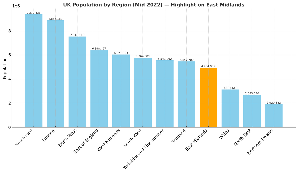
Population of The East Midlands
The East Midlands is home to just under 4.94 million people (mid-2022, ONS). Spanning 15,623 square kilometres (6,032 square miles), the region has a population density of 316 people per square kilometre.
How it compares to the rest of England
- Population share: The East Midlands accounts for 8.6% of England’s total 57.1 million residents, ranking 8th out of 9 regions by population size.
- Space to spread out: With 316 people per km², the region is less densely populated than most of England—122 people per km² fewer than the national average of 438. This puts it 7th out of 9 regions for population density.