Windsor and Maidenhead
§ This page gives an overview of the Windsor and Maidenhead local authority district, bringing together key facts, maps, and data to help you quickly understand the area. This is one of 361 LAD profiles on Baseview.
Overview ⁞ Windsor and Maidenhead lies along the Thames Valley in Berkshire, with Windsor Castle as its most iconic landmark. Windsor Great Park offers extensive woodland and lakes, while the River Thames winds through, with riverside towns and villages such as Eton and Bray. Maidenhead provides a lively town centre with riverside walks and bridges, while Cookham and Marlow nearby add cultural and scenic interest. The district’s geography combines royal heritage, river landscapes, and attractive towns.
Windsor and Maidenhead Boundary Map
This map shows the official boundary of the Windsor and Maidenhead local authority district, based on the latest geographic data published by the Office for National Statistics (ONS). It provides a clear view of the district’s extent and helps you understand how the area fits within the wider regional and national landscape.
Contains OS data © Crown copyright and database right 2025. Source: Office for National Statistics licensed under the Open Government Licence v3.0.
The administrative boundary of Windsor and Maidenhead can also be viewed on OpenStreetMap: District Boundary of Windsor and Maidenhead.
Key Facts about Windsor and Maidenhead
What region are Windsor and Maidenhead in? Windsor and Maidenhead are in the South East of England, a region within the UK.
What county is Windsor and Maidenhead in? Windsor and Maidenhead is in the county of Berkshire.
Is Windsor and Maidenhead a city? No, Windsor and Maidenhead is not a city. (Note: the UK has 76 officially designated cities.)
Who governs Windsor and Maidenhead? The local government for this district is: Windsor and Maidenhead Borough Council (Unitary Authority).
▶ Official website of Windsor and Maidenhead Borough Council 🔗 rbwm.gov.uk
Which police force covers Windsor and Maidenhead? Policing in Windsor and Maidenhead is provided by Thames Valley Police 🔗 thamesvalley.police.uk, which serves 13 local authority districts: Bracknell Forest ⁞ Buckinghamshire ⁞ Cherwell ⁞ Milton Keynes ⁞ Oxford ⁞ Reading ⁞ Slough ⁞ South Oxfordshire ⁞ Vale of White Horse ⁞ West Berkshire ⁞ West Oxfordshire ⁞ Windsor and Maidenhead ⁞ Wokingham.
Constituencies in Windsor and Maidenhead
Windsor and Maidenhead is divided into 2 parliamentary constituencies, listed below in alphabetical order.
A constituency is a specific geographical area that elects one Member of Parliament (MP) to represent them in the House of Commons. The United Kingdom is divided into 650 parliamentary constituencies. We have this list page for easy browsing of all UK parliamentary constituencies: List of Constituencies.
Wards in Windsor and Maidenhead
Windsor and Maidenhead is divided into 19 wards, listed below in alphabetical order.
- Ascot & Sunninghill
- Belmont
- Bisham & Cookham
- Boyn Hill
- Bray
- Clewer & Dedworth East
- Clewer & Dedworth West
- Clewer East
- Cox Green
- Datchet, Horton & Wraysbury
- Eton & Castle
- Furze Platt
- Hurley & Walthams
- Old Windsor
- Oldfield
- Pinkneys Green
- Riverside
- St Mary's
- Sunningdale & Cheapside
In the UK, a ward is a subdivision of a local authority area, used mainly for electoral and statistical purposes. Defined by the ONS, wards represent the primary unit for local elections, each returning one or more councillors to the local council. Wards are also used as a key geography for presenting population and census data. We have this list page for easy browsing of all electoral wards: List of all Electoral Wards in the UK.
Parishes in Windsor and Maidenhead
Windsor and Maidenhead is part-parished: 15 civil parishes (listed A-Z below) alongside 2 unparished areas.
- Bisham
- Bray
- Cookham
- Cox Green
- Datchet
- Eton
- Horton
- Hurley
- Old Windsor
- Shottesbrooke
- Sunningdale
- Sunninghill and Ascot
- Waltham St. Lawrence
- White Waltham
- Wraysbury
A civil parish is the lowest tier of local government in England, used for villages, small towns, and suburbs. They have their own local authority, either a parish council or a parish meeting, which provides local services like managing parks, allotments, and streetlights, and represents the community's views to larger councils.
We have this list page for easy browsing of all parishes: List of Civil Parishes in England and Wales.
Post Towns in Windsor and Maidenhead
Below is a list of post towns in Windsor and Maidenhead, grouped by postcode area:
- SL ▸ Ascot (SL5) ⁞ Maidenhead (SL6 / SL60) ⁞ Windsor (SL4)
The UK postal hierarchy begins with broad postcode areas (such as “CB” or “M”), which are divided into smaller postcode districts (such as “CB8” or “M1”) to support accurate mail routing. Each postal address is anchored by a designated post town, the official locality name used in the UK postcode system, which operates independently from Local Authority Districts —the administrative boundaries used for council tax and local government services. Because they serve different purposes, a property’s postal address and its local authority district do not always align exactly.
Built-up Areas in Windsor and Maidenhead
Windsor and Maidenhead covers 41 built-up areas, listed below in alphabetical order.
- Ascot *
- Bishopsgate *
- Bourne End *
- Bray *
- Burchett's Green
- Colnbrook *
- Cookham *
- Cranbourne *
- Crazies Hill and Cockpole Green *
- Datchet
- Dorney Reach *
- Egham *
- Eton *
- Eton Wick *
- Fifield
- Holloway (Windsor and Maidenhead)
- Holyport
- Horton (Windsor and Maidenhead) *
- Hurley (Windsor and Maidenhead) *
- Hythe End *
- Knowl Hill *
- Littlewick Green
- Maidenhead *
- Marlow *
- Oakley Green
- Old Windsor and Wraysbury *
- Paley Street
- Runnymede *
- Shurlock Row
- Slough *
- South Ascot *
- Staines-upon-Thames *
- Stud Green
- Touchen-end
- Waltham St Lawrence
- Water Oakley
- West End (Windsor and Maidenhead) *
- Windlesham *
- Windsor
- Woodside *
- Woolley Green
In the UK, a Built-up Area (BUA) is a continuous urban area of at least 20 hectares (0.2 km²), defined by the ONS as land where buildings are generally no more than 200 metres apart, such as towns, cities, or large villages. (Note: A BUA name marked with an asterisk (*) indicates that the area is situated partly in the district of Windsor and Maidenhead.)
We have this list page for easy browsing of all built-up areas: List of all Built-up Areas in GB.
Railway Stations in Windsor and Maidenhead
Windsor and Maidenhead is served by a number of National Rail stations, providing rail connections to nearby towns, cities, and destinations across Great Britain. The railway stations listed below are located within the Windsor and Maidenhead Local Authority District and are grouped by train operating company for clarity.
- Great Western Railway ▸ Maidenhead (SL6 1EW) ⁞ Windsor and Eton Central (SL4 1PJ) ⁞ Cookham (SL6 9BP) ⁞ Furze Platt (SL6 7NY)
- South Western Railway ▸ Windsor and Eton Riverside (SL4 1QG) ⁞ Ascot (Berks) (SL5 9EG) ⁞ Sunningdale (SL5 0EL) ⁞ Datchet (SL3 9ED) ⁞ Wraysbury (TW19 5NJ) ⁞ Sunnymeads (TW19 5HQ)
This is a district-level view only. For a complete list of all National Rail stations across Great Britain, see the UK National Rail Stations Directory.
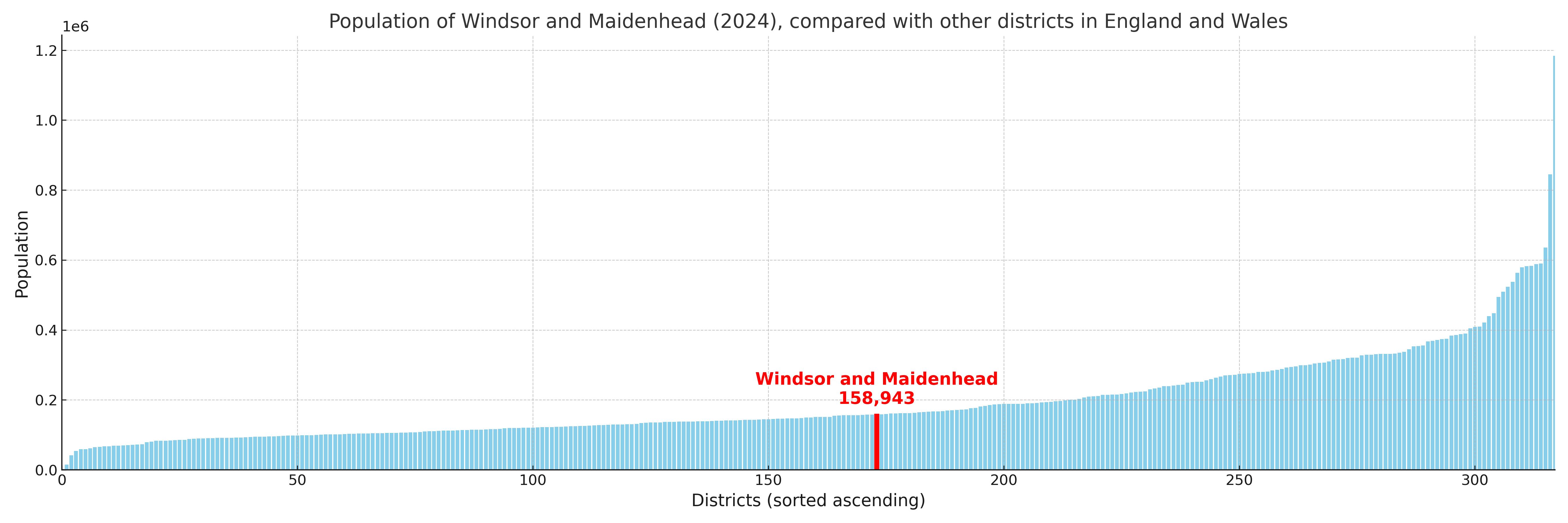
Windsor and Maidenhead compared with other districts in the UK
This section shows how Windsor and Maidenhead compares with other local authority districts in the UK, using a variety of measures and rankings.
Windsor and Maidenhead has 19 electoral wards.

Windsor and Maidenhead has a population of 158,943 (2024 mid-year estimate by ONS)
Population and Migration Trends in Windsor and Maidenhead
This chart shows the population trend for Windsor and Maidenhead from 2015 to 2024. It provides a quick overview of whether the local authority is growing, stable, or declining over time, and helps set context for the migration patterns shown below.
Population change is influenced by natural change (births minus deaths) and migration. The net migration chart below focuses on migration, separating internal migration (moves within the UK) from international migration (moves to and from abroad). Positive values indicate net inflows, while negative values indicate net outflows. The rate labels (per 1,000 residents) help compare migration intensity across years, even when the population size changes.
More local statistics and data for Windsor and Maidenhead can be found on the ONS statistics for Windsor and Maidenhead.
Latest news about Windsor and Maidenhead
Use the search box, or suggested search phrases, below to find recent news, council updates, planning stories, housing developments, transport changes, public services news, local elections, community issues and other local developments related to Windsor and Maidenhead. Results may include coverage from UK national, regional and local news websites, as well as official public-sector and local democracy sources.
- Windsor and Maidenhead council
- Windsor and Maidenhead planning
- Windsor and Maidenhead local elections
- Windsor and Maidenhead housing
- Windsor and Maidenhead transport
- Windsor and Maidenhead regeneration
- Windsor and Maidenhead public services