New Forest
§ This page gives an overview of the New Forest local authority district, bringing together key facts, maps, and data to help you quickly understand the area. This is one of 361 LAD profiles on Baseview.
Overview ⁞ The New Forest district encompasses much of the New Forest National Park, a landscape of ancient woodland, heath, and pasture where ponies, cattle, and deer roam freely. Towns such as Lyndhurst, Brockenhurst, and Lymington provide charm, with Lymington noted for its marina and sailing heritage. The coastline along the Solent offers saltmarshes, beaches, and views towards the Isle of Wight. Villages with thatched cottages and historic churches dot the countryside, giving the area a unique rural and coastal blend.
New Forest Boundary Map
This map shows the official boundary of the New Forest local authority district, based on the latest geographic data published by the Office for National Statistics (ONS). It provides a clear view of the district’s extent and helps you understand how the area fits within the wider regional and national landscape.
Contains OS data © Crown copyright and database right 2025. Source: Office for National Statistics licensed under the Open Government Licence v3.0.
The administrative boundary of New Forest can also be viewed on OpenStreetMap: District Boundary of New Forest.
Key Facts about New Forest
What region is New Forest in? New Forest is in the South East of England, a region within the UK.
What county is New Forest in? New Forest is located in the county of Hampshire.
Is New Forest a city? No, New Forest is not a city. (Note: the UK has 76 officially designated cities.)
Who governs New Forest? The local authority for this district is: New Forest District Council - responsible for district-level services. Since Hampshire is a two-tier area, county-level services are handled by: Hampshire County Council.
▶ Official website of New Forest District Council 🔗 newforest.gov.uk
Which police force covers New Forest? Policing in New Forest is provided by Hampshire Constabulary 🔗 hampshire.police.uk, which serves 14 local authority districts: Basingstoke and Deane ⁞ East Hampshire ⁞ Eastleigh ⁞ Fareham ⁞ Gosport ⁞ Hart ⁞ Havant ⁞ Isle of Wight ⁞ New Forest ⁞ Portsmouth ⁞ Rushmoor ⁞ Southampton ⁞ Test Valley ⁞ Winchester.
Constituencies in New Forest
New Forest is divided into 2 parliamentary constituencies, listed below in alphabetical order.
A constituency is a specific geographical area that elects one Member of Parliament (MP) to represent them in the House of Commons. The United Kingdom is divided into 650 parliamentary constituencies. We have this list page for easy browsing of all UK parliamentary constituencies: List of Constituencies.
Wards in New Forest
New Forest is divided into 26 wards, listed below in alphabetical order.
- Ashley, Bashley & Fernhill
- Ashurst, Bramshaw, Copythorne & Netley Marsh
- Ballard
- Barton & Becton
- Bransgore, Burley, Sopley & Ringwood East
- Brockenhurst & Denny Lodge
- Dibden & Dibden Purlieu
- Downlands & Forest North
- Fawley, Blackfield, Calshot & Langley
- Fordingbridge, Godshill & Hyde
- Forest & Solent
- Hardley, Holbury & North Blackfield
- Hythe Central
- Hythe South
- Lymington
- Lyndhurst & Minstead
- Marchwood & Eling
- Milford & Hordle
- Milton
- Pennington
- Ringwood North & Ellingham
- Ringwood South
- Sway
- Totton Central
- Totton North
- Totton South
In the UK, a ward is a subdivision of a local authority area, used mainly for electoral and statistical purposes. Defined by the ONS, wards represent the primary unit for local elections, each returning one or more councillors to the local council. Wards are also used as a key geography for presenting population and census data. We have this list page for easy browsing of all electoral wards: List of all Electoral Wards in the UK.
Parishes in New Forest
New Forest is part-parished: 37 civil parishes (listed A-Z below) alongside 1 unparished areas.
- Ashurst and Colbury
- Beaulieu
- Boldre
- Bramshaw
- Bransgore
- Breamore
- Brockenhurst
- Burley
- Copythorne
- Damerham
- Denny Lodge
- East Boldre
- Ellingham, Harbridge and Ibsley
- Exbury and Lepe
- Fawley
- Fordingbridge
- Godshill
- Hale
- Hordle
- Hyde
- Hythe and Dibden
- Lymington and Pennington
- Lyndhurst
- Marchwood
- Martin
- Milford-on-sea
- Minstead
- Netley Marsh
- New Milton
- Ringwood
- Rockbourne
- Sandleheath
- Sopley
- Sway
- Totton and Eling
- Whitsbury
- Woodgreen
A civil parish is the lowest tier of local government in England, used for villages, small towns, and suburbs. They have their own local authority, either a parish council or a parish meeting, which provides local services like managing parks, allotments, and streetlights, and represents the community's views to larger councils.
We have this list page for easy browsing of all parishes: List of Civil Parishes in England and Wales.
Post Towns in New Forest
Below is a list of post towns in New Forest, grouped by postcode area:
- BH ▸ New Milton (BH25) ⁞ Ringwood (BH24)
- SO ▸ Brockenhurst (SO42) ⁞ Lymington (SO41) ⁞ Lyndhurst (SO40 / SO43)
- SP ▸ Fordingbridge (SP6)
The UK postal hierarchy begins with broad postcode areas (such as “CB” or “M”), which are divided into smaller postcode districts (such as “CB8” or “M1”) to support accurate mail routing. Each postal address is anchored by a designated post town, the official locality name used in the UK postcode system, which operates independently from Local Authority Districts —the administrative boundaries used for council tax and local government services. Because they serve different purposes, a property’s postal address and its local authority district do not always align exactly.
Built-up Areas in New Forest
New Forest covers 58 built-up areas, listed below in alphabetical order.
- Alderholt *
- Ashley (New Forest)
- Ashley Heath *
- Ashurst
- Barton on Sea *
- Bashley
- Beaulieu
- Blackfield and Langley
- Blackhill *
- Bransgore *
- Breamore
- Brockenhurst
- Burley
- Burley Street
- Cadnam and Bartley
- Christchurch (Bournemouth, Christchurch and Poole) *
- East Boldre
- East Wellow *
- Everton (New Forest)
- Fordingbridge
- Frogham
- Godshill (New Forest)
- Hangersley
- Hightown (New Forest)
- Holbury
- Hordle
- Hyde (New Forest)
- Hythe and Dibden Purlieu
- Keyhaven
- Landford and Nomansland *
- Lymington
- Lyndhurst
- Marchwood
- Martin (New Forest)
- Milford on Sea
- Minstead
- Mount Pleasant
- New Milton
- Ower (Copythorne)
- Ower (Fawley)
- Pilley
- Redlynch and Woodfalls *
- Ringwood
- Rockbourne
- Sandleheath
- Sandy Down
- Sopley *
- Southampton *
- Sway
- Thorney Hill
- Tiptoe
- Totton *
- Verwood *
- Walhampton and Portmore
- West Wellow *
- Woodgreen
- Woodlands
- Wootton (New Forest)
In the UK, a Built-up Area (BUA) is a continuous urban area of at least 20 hectares (0.2 km²), defined by the ONS as land where buildings are generally no more than 200 metres apart, such as towns, cities, or large villages. (Note: A BUA name marked with an asterisk (*) indicates that the area is situated partly in the district of New Forest.)
We have this list page for easy browsing of all built-up areas: List of all Built-up Areas in GB.
Railway Stations in New Forest
New Forest is served by a number of National Rail stations, providing rail connections to nearby towns, cities, and destinations across Great Britain. The railway stations listed below are located within the New Forest Local Authority District and are grouped by train operating company for clarity.
- South Western Railway ▸ Brockenhurst (SO42 7TW) ⁞ New Milton (BH25 6JS) ⁞ Lymington Town (SO41 9AZ) ⁞ Totton (SO40 3AB) ⁞ Hinton Admiral (BH23 7DW) ⁞ Ashurst New Forest (SO40 7AA) ⁞ Lymington Pier (SO41 5ZE) ⁞ Sway (SO41 6BA) ⁞ Beaulieu Road (SO42 7YQ)
This is a district-level view only. For a complete list of all National Rail stations across Great Britain, see the UK National Rail Stations Directory.
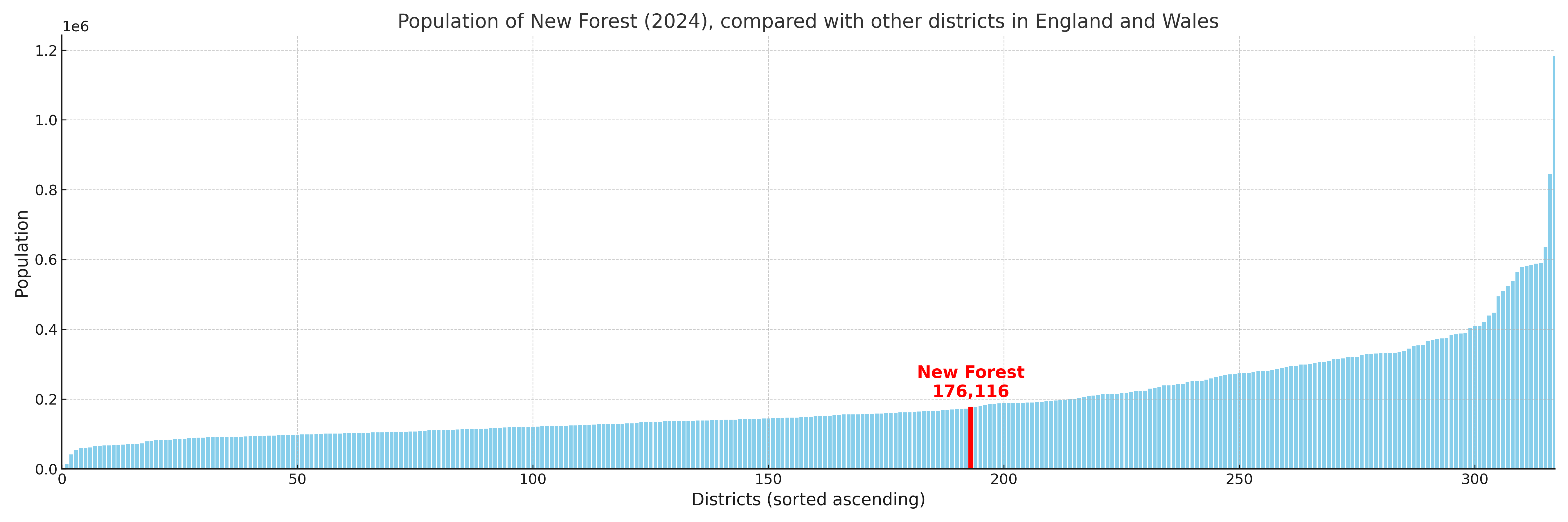
New Forest compared with other districts in the UK
This section shows how New Forest compares with other local authority districts in the UK, using a variety of measures and rankings.
New Forest has 26 electoral wards.

New Forest has a population of 176,116 (2024 mid-year estimate by ONS)
Population and Migration Trends in New Forest
This chart shows the population trend for New Forest from 2015 to 2024. It provides a quick overview of whether the local authority is growing, stable, or declining over time, and helps set context for the migration patterns shown below.
Population change is influenced by natural change (births minus deaths) and migration. The net migration chart below focuses on migration, separating internal migration (moves within the UK) from international migration (moves to and from abroad). Positive values indicate net inflows, while negative values indicate net outflows. The rate labels (per 1,000 residents) help compare migration intensity across years, even when the population size changes.
More local statistics and data for New Forest can be found on the ONS statistics for New Forest.
Latest news about New Forest
Use the search box, or suggested search phrases, below to find recent news, council updates, planning stories, housing developments, transport changes, public services news, local elections, community issues and other local developments related to New Forest. Results may include coverage from UK national, regional and local news websites, as well as official public-sector and local democracy sources.
- New Forest council
- New Forest planning
- New Forest local elections
- New Forest housing
- New Forest transport
- New Forest regeneration
- New Forest public services