London
§ This page provides an overview of UK's London region, with key facts and data. Last updated on .
Overview ⁞ As the capital of the UK and England, London is a global financial, cultural, and political powerhouse. With iconic landmarks like the Houses of Parliament, Buckingham Palace, and the Tower of London, it’s a city steeped in history. London is incredibly diverse, home to over 8 million people from all over the world, and is a hub for media, education, and the arts.
Greater London is a unique administrative region that functions both as a ceremonial county and a devolved region with its own directly elected mayor and assembly. It is subdivided into 32 London boroughs and the City of London, which is a separate entity with its own governance. The boroughs operate as unitary authorities, responsible for most local government functions. London’s dense urban fabric encompasses everything from historic centres and financial districts to residential suburbs, with administrative lines often following patterns of historical development and transport infrastructure rather than natural geography.
Greater London and the City of London
Greater London is comprised of 32 London boroughs and the City of London. These London boroughs are administrative units within Greater London region, each with its own local council. The City of London, which is often referred to as the “Square Mile”, has its own unique local government, the City of London Corporation, and its own police force, while the rest of Greater London is governed by the 32 boroughs and the Metropolitan Police Service.
London Boroughs
The UK is divided into Local Authority Districts (LADs) as the main building blocks of local government and statistical geography. In Greater London region, LADs are 32 London boroughs plus the City of London.
- Inner London ▸ Camden ⁞ City of London ⁞ Hackney ⁞ Hammersmith and Fulham ⁞ Haringey ⁞ Islington ⁞ Kensington and Chelsea ⁞ Lambeth ⁞ Lewisham ⁞ Newham ⁞ Southwark ⁞ Tower Hamlets ⁞ Wandsworth ⁞ Westminster
- Outer London ▸ Barking and Dagenham ⁞ Barnet ⁞ Bexley ⁞ Brent ⁞ Bromley ⁞ Croydon ⁞ Ealing ⁞ Enfield ⁞ Greenwich ⁞ Harrow ⁞ Havering ⁞ Hillingdon ⁞ Hounslow ⁞ Kingston upon Thames ⁞ Merton ⁞ Redbridge ⁞ Richmond upon Thames ⁞ Sutton ⁞ Waltham Forest
Cities in London
London is unique among the UK’s regions in that it contains two distinct and historic cities, each with a different constitutional and administrative status. The City of Westminster is a London borough that holds city status by royal charter, while the City of London is a self-governing historic city with its own local authority and ceremonial county. Together, they represent the only officially designated cities within Greater London, both distinguished by the honour of a Lord Mayor.
City of Westminster
- Local authority
- Westminster (London borough)
- Civic honour
- Lord Mayor
- City status granted
- 1540
City of London
- Local authority
- City of London Corporation (unique authority and ceremonial county)
- Civic honour
- Lord Mayor
- City status granted
- ancient
Post Towns in London
Below is a complete list of post towns in London, grouped by postcode area to make browsing easier.
- BR ▸ Beckenham ⁞ Bromley ⁞ Chislehurst ⁞ Keston ⁞ Orpington ⁞ Swanley ⁞ West Wickham
- E ▸ London
- EC ▸ London
- HA ▸ Edgware ⁞ Harrow ⁞ Northwood ⁞ Pinner ⁞ Ruislip ⁞ Stanmore ⁞ Wembley
- IG ▸ Barking ⁞ Buckhurst Hill ⁞ Chigwell ⁞ Ilford ⁞ Loughton ⁞ Woodford Green
- N ▸ London
- NW ▸ London
- SE ▸ London
- SW ▸ London
- UB ▸ Greenford ⁞ Hayes ⁞ Northolt ⁞ Southall ⁞ Uxbridge ⁞ West Drayton
- W ▸ London
- WC ▸ London
International Territorial Levels in London Region
The International Territorial Levels (ITLs) are a hierarchical system of geographic boundaries used for statistical purposes, specifically for regional data analysis and international comparisons. It has three levels: ITL1, ITL2, and ITL3, with ITL1 being the broadest level and ITL3 the most detailed.
London Region is one of ITL 1 areas in the UK. It is then divided ino the following ITL 2 areas (names in bold letters) and ITL 3 areas.
- Inner London - West — Kensington & Chelsea and Hammersmith & Fulham ⁞ Wandsworth ⁞ Westminster and City of London ⁞ Camden
- Inner London - East — Hackney and Newham ⁞ Tower Hamlets ⁞ Haringey and Islington ⁞ Lewisham and Southwark ⁞ Lambeth
- Outer London - East and North East — Bexley and Greenwich ⁞ Barking & Dagenham and Havering ⁞ Redbridge and Waltham Forest ⁞ Enfield
- Outer London - South — Bromley ⁞ Croydon ⁞ Merton, Kingston upon Thames and Sutton
- Outer London - West and North West — Barnet ⁞ Brent ⁞ Ealing ⁞ Harrow and Hillingdon ⁞ Hounslow and Richmond upon Thames
Constituencies in London
London has 75 parliamentary constituencies, encompassing diverse areas from densely populated inner-city districts to suburban zones. Political issues range from housing and transport to economic growth and cultural investment.
- Barking
- Battersea
- Beckenham and Penge
- Bermondsey and Old Southwark
- Bethnal Green and Stepney
- Bexleyheath and Crayford
- Brent East
- Brent West
- Brentford and Isleworth
- Bromley and Biggin Hill
- Carshalton and Wallington
- Chelsea and Fulham
- Chingford and Woodford Green
- Chipping Barnet
- Cities of London and Westminster
- Clapham and Brixton Hill
- Croydon East
- Croydon South
- Croydon West
- Dagenham and Rainham
- Dulwich and West Norwood
- Ealing Central and Acton
- Ealing North
- Ealing Southall
- East Ham
- Edmonton and Winchmore Hill
- Eltham and Chislehurst
- Enfield North
- Erith and Thamesmead
- Feltham and Heston
- Finchley and Golders Green
- Greenwich and Woolwich
- Hackney North and Stoke Newington
- Hackney South and Shoreditch
- Hammersmith and Chiswick
- Hampstead and Highgate
- Harrow East
- Harrow West
- Hayes and Harlington
- Hendon
- Holborn and St Pancras
- Hornchurch and Upminster
- Hornsey and Friern Barnet
- Ilford North
- Ilford South
- Islington North
- Islington South and Finsbury
- Kensington and Bayswater
- Kingston and Surbiton
- Lewisham East
- Lewisham North
- Lewisham West and East Dulwich
- Leyton and Wanstead
- Mitcham and Morden
- Old Bexley and Sidcup
- Orpington
- Peckham
- Poplar and Limehouse
- Putney
- Queen's Park and Maida Vale
- Richmond Park
- Romford
- Ruislip, Northwood and Pinner
- Southgate and Wood Green
- Stratford and Bow
- Streatham and Croydon North
- Sutton and Cheam
- Tooting
- Tottenham
- Twickenham
- Uxbridge and South Ruislip
- Vauxhall and Camberwell Green
- Walthamstow
- West Ham and Beckton
- Wimbledon
Population of London
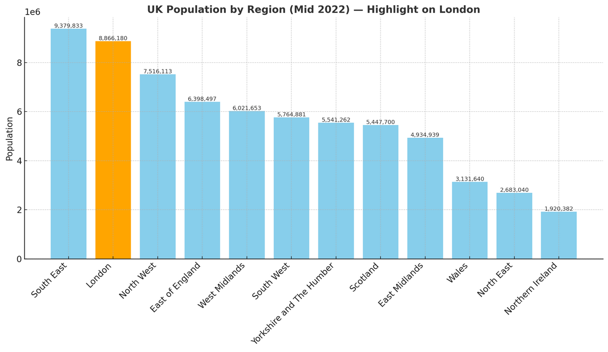
London is home to around 8.87 million people (mid-2022, ONS). Spread across just 1,572 square kilometres (607 square miles), the capital has an impressive population density of 5,640 people per square kilometre—by far the highest in England.
How it compares to the rest of England
- Population share: London accounts for 15.5% of England’s total 57.1 million residents, making it the 2nd most populated region, just behind the South East.
- Population density: At 5,640 people per km², London is extraordinarily crowded compared to the national average of 438 people per km²—5,202 more people per km²—making it the densest region in England by a wide margin.