North East
§ This page provides an overview of UK's North East region, with key facts and data. Last updated on .
Overview ⁞ The North East of England is known for its rugged coastline, national parks, and industrial heritage in coal mining and shipbuilding. Bordering Scotland to the north and the North Sea to the east, it combines vibrant cities like Newcastle upon Tyne, Sunderland, and Durham with rural landscapes such as Northumberland National Park. Tourism, energy, and advanced manufacturing play key roles in its economy.
The region includes both metropolitan and rural areas. Tyne and Wear contains major urban hubs governed by metropolitan borough councils, while Northumberland and County Durham cover more rural areas with unitary or county councils. Governance reflects a mix of historic county divisions and modern local authority structures.
Ceremonial Counties in North East region
The North East consists of three ceremonial counties: County Durham, Northumberland, and Tyne and Wear. Each offers a unique character, from the scenic uplands of Northumberland to the cultural and industrial heartlands of Durham and Tyneside.
Districts in North East
The UK is divided into Local Authority Districts (LADs) as the main building blocks of local government and statistical geography. The following lists all the LADs in this region.
- Unitary Authorities ▸ County Durham ⁞ Darlington ⁞ Hartlepool ⁞ Middlesbrough ⁞ Northumberland ⁞ Redcar and Cleveland ⁞ Stockton-on-Tees
- Tyne and Wear ▸ Gateshead ⁞ Newcastle upon Tyne ⁞ North Tyneside ⁞ South Tyneside ⁞ Sunderland
Cities in North East
North East is home to several officially designated cities, each holding city status by royal charter rather than population size alone. Below is a complete list of cities in the region, including their local authorities, administrative geography, ceremonial honours, and the year city status was granted.
City of Newcastle upon Tyne
- Local authority
- Newcastle upon Tyne (Metropolitan borough)
- Ceremonial county
- Tyne and Wear
- Civic honour
- Lord Mayor
- City status granted
- 1882
Durham
- Local authority
- County Durham (Unitary Authority)
- City status holder
- Charter Trustees of the City of Durham (Charter trustees)
- Ceremonial county
- County Durham
- Civic honour
- No additional civic honour
- City status granted
- 1974
City of Sunderland
- Local authority
- Sunderland (Metropolitan borough)
- Ceremonial county
- Tyne and Wear
- Civic honour
- No additional civic honour
- City status granted
- 1992
Post Towns in North East
Below is a complete list of post towns in North East, grouped by postcode area to make browsing easier.
- DH ▸ Chester le Street ⁞ Consett ⁞ Durham ⁞ Houghton le Spring ⁞ Stanley
- DL ▸ Barnard Castle ⁞ Bedale ⁞ Bishop Auckland ⁞ Catterick Garrison ⁞ Crook ⁞ Darlington ⁞ Ferryhill ⁞ Hawes ⁞ Leyburn ⁞ Newton Aycliffe ⁞ Northallerton ⁞ Richmond ⁞ Shildon ⁞ Spennymoor
- NE ▸ Alnwick ⁞ Ashington ⁞ Bamburgh ⁞ Bedlington ⁞ Belford ⁞ Blaydon-on-Tyne ⁞ Blyth ⁞ Boldon Colliery ⁞ Chathill ⁞ Choppington ⁞ Corbridge ⁞ Cramlington ⁞ East Boldon ⁞ Gateshead ⁞ Haltwhistle ⁞ Hebburn ⁞ Hexham ⁞ Jarrow ⁞ Morpeth ⁞ Newbiggin-by-the-Sea ⁞ Newcastle upon Tyne ⁞ North Shields ⁞ Prudhoe ⁞ Riding Mill ⁞ Rowlands Gill ⁞ Ryton ⁞ Seahouses ⁞ South Shields ⁞ Stocksfield ⁞ Wallsend ⁞ Washington ⁞ Whitley Bay ⁞ Wooler ⁞ Wylam
- SR ▸ Peterlee ⁞ Seaham ⁞ Sunderland
- TS ▸ Billingham ⁞ Guisborough ⁞ Hartlepool ⁞ Middlesbrough ⁞ Redcar ⁞ Saltburn-by-the-Sea ⁞ Stockton-on-Tees ⁞ Trimdon Station ⁞ Wingate ⁞ Yarm
International Territorial Levels in North East Region
The International Territorial Levels (ITLs) are a hierarchical system of geographic boundaries used for statistical purposes, specifically for regional data analysis and international comparisons. It has three levels: ITL1, ITL2, and ITL3, with ITL1 being the broadest level and ITL3 the most detailed.
North East Region is one of ITL 1 areas in the UK. It is then divided ino the following ITL 2 areas (names in bold letters) and ITL 3 areas.
- Tees Valley — Hartlepool and Stockton-on-Tees ⁞ South Teesside ⁞ Darlington
- Northumberland, Durham and Tyne & Wear — Durham ⁞ Northumberland ⁞ Tyneside ⁞ Sunderland
Constituencies in North East
The region has 27 parliamentary constituencies, spanning cities such as Newcastle, Sunderland, and Middlesbrough, as well as smaller towns and rural communities. Though smaller in seat numbers than other UK regions, its marginal constituencies are politically important in national elections.
- Bishop Auckland
- Blaydon and Consett
- Blyth and Ashington
- City of Durham
- Cramlington and Killingworth
- Darlington
- Easington
- Gateshead Central and Whickham
- Hartlepool
- Hexham
- Houghton and Sunderland South
- Jarrow and Gateshead East
- Middlesbrough and Thornaby East
- Middlesbrough South and East Cleveland
- Newcastle upon Tyne Central and West
- Newcastle upon Tyne East and Wallsend
- Newcastle upon Tyne North
- Newton Aycliffe and Spennymoor
- North Durham
- North Northumberland
- Redcar
- South Shields
- Stockton North
- Stockton West
- Sunderland Central
- Tynemouth
- Washington and Gateshead South
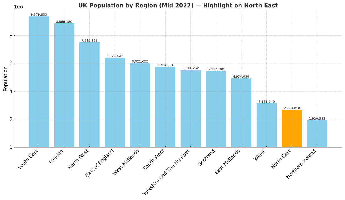
Population of North East England
North East England is home to just over 2.68 million people (mid-2022, ONS). Spread across 8,574 square kilometres (3,311 square miles), that works out to around 313 people per square kilometre.
How it compares to the rest of England
- Size in numbers: The region’s population makes up only 4.7% of England’s total 57.1 million residents, making it the least populated of England’s nine regions.
- Room to breathe: With 313 people per km², the North East is less crowded than most places in England—about 125 people per km² fewer than the national average of 438. That puts it second only to one other region for having the lowest population density.