East Hampshire
§ This page gives an overview of the East Hampshire local authority district, bringing together key facts, maps, and data to help you quickly understand the area. This is one of 361 LAD profiles on Baseview.
Overview ⁞ East Hampshire covers a largely rural landscape of rolling hills, villages, and historic towns. Petersfield, nestled within the South Downs National Park, is the main centre, with a market square, lake, and access to the surrounding countryside. Alton adds heritage with links to Jane Austen at nearby Chawton, while villages across the district feature traditional cottages and churches. The South Downs Way runs through, providing walking and cycling trails, while woodland, rivers, and farmland define its varied terrain.
East Hampshire Boundary Map
This map shows the official boundary of the East Hampshire local authority district, based on the latest geographic data published by the Office for National Statistics (ONS). It provides a clear view of the district’s extent and helps you understand how the area fits within the wider regional and national landscape.
Contains OS data © Crown copyright and database right 2025. Source: Office for National Statistics licensed under the Open Government Licence v3.0.
The administrative boundary of East Hampshire can also be viewed on OpenStreetMap: District Boundary of East Hampshire.
Key Facts about East Hampshire
What region is East Hampshire in? East Hampshire is in the South East of England, a region within the UK.
What county is East Hampshire in? East Hampshire is located in the county of Hampshire.
Is East Hampshire a city? No, East Hampshire is not a city. (Note: the UK has 76 officially designated cities.)
Who governs East Hampshire? The local authority for this district is: East Hampshire District Council - responsible for district-level services. Since Hampshire is a two-tier area, county-level services are handled by: Hampshire County Council.
▶ Official website of East Hampshire District Council 🔗 easthants.gov.uk
Which police force covers East Hampshire? Policing in East Hampshire is provided by Hampshire Constabulary 🔗 hampshire.police.uk, which serves 14 local authority districts: Basingstoke and Deane ⁞ East Hampshire ⁞ Eastleigh ⁞ Fareham ⁞ Gosport ⁞ Hart ⁞ Havant ⁞ Isle of Wight ⁞ New Forest ⁞ Portsmouth ⁞ Rushmoor ⁞ Southampton ⁞ Test Valley ⁞ Winchester.
Constituencies in East Hampshire
East Hampshire is divided into 2 parliamentary constituencies, listed below in alphabetical order.
A constituency is a specific geographical area that elects one Member of Parliament (MP) to represent them in the House of Commons. The United Kingdom is divided into 650 parliamentary constituencies. We have this list page for easy browsing of all UK parliamentary constituencies: List of Constituencies.
Wards in East Hampshire
East Hampshire is divided into 31 wards, listed below in alphabetical order.
- Alton Amery
- Alton Ashdell
- Alton Eastbrooke
- Alton Holybourne
- Alton Westbrooke
- Alton Whitedown
- Alton Wooteys
- Bentworth & Froyle
- Binsted, Bentley & Selborne
- Bramshott & Liphook
- Buriton & East Meon
- Clanfield
- Four Marks & Medstead
- Froxfield, Sheet & Steep
- Grayshott
- Headley
- Horndean Catherington
- Horndean Downs
- Horndean Kings & Blendworth
- Horndean Murray
- Lindford
- Liss
- Petersfield Bell Hill
- Petersfield Causeway
- Petersfield Heath
- Petersfield St Peter's
- Ropley, Hawkley & Hangers
- Rowlands Castle
- Whitehill Chase
- Whitehill Hogmoor & Greatham
- Whitehill Pinewood
In the UK, a ward is a subdivision of a local authority area, used mainly for electoral and statistical purposes. Defined by the ONS, wards represent the primary unit for local elections, each returning one or more councillors to the local council. Wards are also used as a key geography for presenting population and census data. We have this list page for easy browsing of all electoral wards: List of all Electoral Wards in the UK.
Parishes in East Hampshire
East Hampshire is fully parished: 40 civil parishes, listed A-Z below.
- Alton
- Beech
- Bentley
- Bentworth
- Binsted
- Bramshott and Liphook
- Buriton
- Chawton
- Clanfield
- Colemore and Priors Dean
- East Meon
- East Tisted
- Farringdon
- Four Marks
- Froxfield and Privett
- Froyle
- Grayshott
- Greatham
- Hawkley
- Headley
- Horndean
- Kingsley
- Langrish
- Lasham
- Lindford
- Liss
- Medstead
- Newton Valence
- Petersfield
- Ropley
- Rowlands Castle
- Selborne
- Shalden
- Sheet
- Steep
- Stroud
- West Tisted
- Whitehill
- Wield
- Worldham
A civil parish is the lowest tier of local government in England, used for villages, small towns, and suburbs. They have their own local authority, either a parish council or a parish meeting, which provides local services like managing parks, allotments, and streetlights, and represents the community's views to larger councils.
We have this list page for easy browsing of all parishes: List of Civil Parishes in England and Wales.
Post Towns in East Hampshire
Below is a list of post towns in East Hampshire, grouped by postcode area:
- GU ▸ Alton (GU34) ⁞ Bordon (GU35) ⁞ Liphook (GU30) ⁞ Liss (GU33) ⁞ Petersfield (GU31 / GU32)
The UK postal hierarchy begins with broad postcode areas (such as “CB” or “M”), which are divided into smaller postcode districts (such as “CB8” or “M1”) to support accurate mail routing. Each postal address is anchored by a designated post town, the official locality name used in the UK postcode system, which operates independently from Local Authority Districts —the administrative boundaries used for council tax and local government services. Because they serve different purposes, a property’s postal address and its local authority district do not always align exactly.
Built-up Areas in East Hampshire
East Hampshire covers 46 built-up areas, listed below in alphabetical order.
- Alton (East Hampshire)
- Beech
- Bentley (East Hampshire)
- Bentworth
- Blacknest
- Bordon
- Bramshott
- Bramshott Chase *
- Buriton
- Catherington
- Churt *
- Clanfield (East Hampshire)
- Dockenfield *
- East Meon
- East Worldham
- Four Marks
- Grayshott
- Greatham (East Hampshire)
- Hammer *
- Havant *
- Headley Down and Headley
- Hill Brow and Rake *
- Hindhead *
- Holybourne
- Horndean *
- Kingsley (East Hampshire)
- Lasham *
- Lindford
- Liphook *
- Liss
- Lower Farringdon
- Medstead
- Monkwood
- Oakhanger
- Petersfield
- Ropley
- Rowlands Castle *
- Selborne
- Sheet (East Hampshire)
- Soldridge *
- Steep
- Upper Farringdon
- Upper Froyle
- Wheatsheaf Common *
- Whitehill (East Hampshire)
- Wrecclesham *
In the UK, a Built-up Area (BUA) is a continuous urban area of at least 20 hectares (0.2 km²), defined by the ONS as land where buildings are generally no more than 200 metres apart, such as towns, cities, or large villages. (Note: A BUA name marked with an asterisk (*) indicates that the area is situated partly in the district of East Hampshire.)
We have this list page for easy browsing of all built-up areas: List of all Built-up Areas in GB.
Railway Stations in East Hampshire
East Hampshire is served by a number of National Rail stations, providing rail connections to nearby towns, cities, and destinations across Great Britain. The railway stations listed below are located within the East Hampshire Local Authority District and are grouped by train operating company for clarity.
- South Western Railway ▸ Petersfield (GU32 3EE) ⁞ Liphook (GU30 7DR) ⁞ Alton (GU34 2PZ) ⁞ Liss (GU33 7AA) ⁞ Rowlands Castle (PO9 6BP) ⁞ Bentley (Hampshire) (GU10 5JZ)
This is a district-level view only. For a complete list of all National Rail stations across Great Britain, see the UK National Rail Stations Directory.
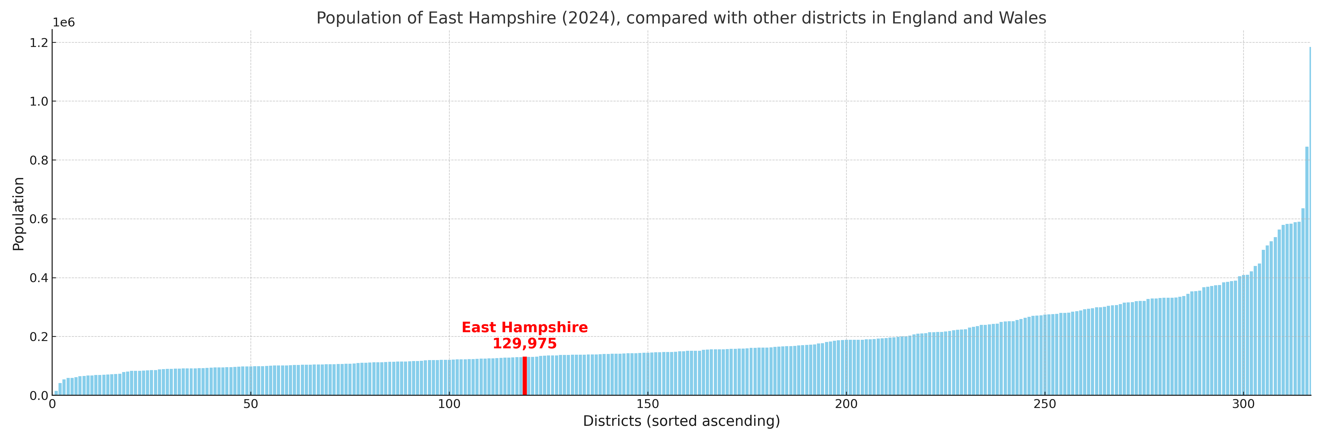
East Hampshire compared with other districts in the UK
This section shows how East Hampshire compares with other local authority districts in the UK, using a variety of measures and rankings.
East Hampshire has 31 electoral wards.

East Hampshire has a population of 129,975 (2024 mid-year estimate by ONS)
Population and Migration Trends in East Hampshire
This chart shows the population trend for East Hampshire from 2015 to 2024. It provides a quick overview of whether the local authority is growing, stable, or declining over time, and helps set context for the migration patterns shown below.
Population change is influenced by natural change (births minus deaths) and migration. The net migration chart below focuses on migration, separating internal migration (moves within the UK) from international migration (moves to and from abroad). Positive values indicate net inflows, while negative values indicate net outflows. The rate labels (per 1,000 residents) help compare migration intensity across years, even when the population size changes.
More local statistics and data for East Hampshire can be found on the ONS statistics for East Hampshire.
Latest news about East Hampshire
Use the search box, or suggested search phrases, below to find recent news, council updates, planning stories, housing developments, transport changes, public services news, local elections, community issues and other local developments related to East Hampshire. Results may include coverage from UK national, regional and local news websites, as well as official public-sector and local democracy sources.
- East Hampshire council
- East Hampshire planning
- East Hampshire local elections
- East Hampshire housing
- East Hampshire transport
- East Hampshire regeneration
- East Hampshire public services