Milton Keynes
§ This page gives an overview of the Milton Keynes local authority district, bringing together key facts, maps, and data to help you quickly understand the area. This is one of 361 LAD profiles on Baseview.
Overview ⁞ Milton Keynes, in Buckinghamshire, is a modern planned city laid out with grid roads, lakes, and parks. The centre includes shopping complexes, theatres, and cultural venues, while Bletchley Park, the World War II codebreaking site, is a major landmark. The Grand Union Canal and River Ouzel flow through, while Willen Lake and Campbell Park provide extensive green spaces. Surrounding villages and farmland add rural character. Its geography is a mix of modern urban design and countryside.
Milton Keynes Boundary Map
This map shows the official boundary of the Milton Keynes local authority district, based on the latest geographic data published by the Office for National Statistics (ONS). It provides a clear view of the district’s extent and helps you understand how the area fits within the wider regional and national landscape.
Contains OS data © Crown copyright and database right 2025. Source: Office for National Statistics licensed under the Open Government Licence v3.0.
The administrative boundary of Milton Keynes can also be viewed on OpenStreetMap: District Boundary of Milton Keynes.
Key Facts about Milton Keynes
What region is Milton Keynes in? Milton Keynes is in the South East of England, a region within the UK.
What county is Milton Keynes in? Milton Keynes is in the county of Buckinghamshire.
Is Milton Keynes a city? Yes, Milton Keynes is a city. Milton Keynes holds official city status as one of the 76 designated cities in the UK.
Who governs Milton Keynes? The local government for this district is: Milton Keynes Council (Unitary Authority).
▶ Official website of Milton Keynes Council 🔗 milton-keynes.gov.uk
Which police force covers Milton Keynes? Policing in Milton Keynes is provided by Thames Valley Police 🔗 thamesvalley.police.uk, which serves 13 local authority districts: Bracknell Forest ⁞ Buckinghamshire ⁞ Cherwell ⁞ Milton Keynes ⁞ Oxford ⁞ Reading ⁞ Slough ⁞ South Oxfordshire ⁞ Vale of White Horse ⁞ West Berkshire ⁞ West Oxfordshire ⁞ Windsor and Maidenhead ⁞ Wokingham.
Milton Keynes in International Geographies
In the International Territorial Levels (ITLs) hierarchy, Milton Keynes is an ITLs Level 3 area:
- (ITL 1) South East
- (ITL 2) ⇒ Berkshire, Buckinghamshire and Oxfordshire
- (ITL 3) ⇒⇒ Milton Keynes
The International Territorial Levels are used by OECD member countries for statistical purposes to classify administrative areas. We have this listable page for easy browsing of ITL names and codes: International Territorial Levels.
Constituencies in Milton Keynes
Milton Keynes is divided into 3 parliamentary constituencies, listed below in alphabetical order.
A constituency is a specific geographical area that elects one Member of Parliament (MP) to represent them in the House of Commons. The United Kingdom is divided into 650 parliamentary constituencies. We have this list page for easy browsing of all UK parliamentary constituencies: List of Constituencies.
Wards in Milton Keynes
Milton Keynes is divided into 19 wards, listed below in alphabetical order.
- Bletchley East
- Bletchley Park
- Bletchley West
- Bradwell
- Broughton
- Campbell Park & Old Woughton
- Central Milton Keynes
- Danesborough & Walton
- Loughton & Shenley
- Monkston
- Newport Pagnell North & Hanslope
- Newport Pagnell South
- Olney
- Shenley Brook End
- Stantonbury
- Stony Stratford
- Tattenhoe
- Wolverton
- Woughton & Fishermead
In the UK, a ward is a subdivision of a local authority area, used mainly for electoral and statistical purposes. Defined by the ONS, wards represent the primary unit for local elections, each returning one or more councillors to the local council. Wards are also used as a key geography for presenting population and census data. We have this list page for easy browsing of all electoral wards: List of all Electoral Wards in the UK.
Parishes in Milton Keynes
Milton Keynes is fully parished: 51 civil parishes, listed A-Z below.
- Abbey Hill
- Astwood
- Bletchley and Fenny Stratford
- Bow Brickhill
- Bradwell
- Broughton
- Calverton
- Campbell Park
- Castlethorpe
- Central Milton Keynes
- Chicheley
- Clifton Reynes
- Cold Brayfield
- Emberton
- Fairfields
- Gayhurst
- Great Linford
- Hanslope
- Hardmead
- Haversham-cum-Little Linford
- Kents Hill, Monkston and Brinklow
- Lathbury
- Lavendon
- Little Brickhill
- Loughton & Great Holm
- Milton Keynes
- Moulsoe
- New Bradwell
- Newport Pagnell
- Newton Blossomville
- North Crawley
- Old Woughton
- Olney
- Ravenstone
- Shenley Brook End
- Shenley Church End
- Sherington
- Simpson and Ashland
- Stantonbury
- Stoke Goldington
- Stony Stratford
- Tyringham and Filgrave
- Walton
- Warrington
- Wavendon
- West Bletchley
- Weston Underwood
- Whitehouse
- Woburn Sands
- Wolverton and Greenleys
- Woughton on the Green
A civil parish is the lowest tier of local government in England, used for villages, small towns, and suburbs. They have their own local authority, either a parish council or a parish meeting, which provides local services like managing parks, allotments, and streetlights, and represents the community's views to larger councils.
We have this list page for easy browsing of all parishes: List of Civil Parishes in England and Wales.
Post Towns in Milton Keynes
Below is a list of post towns in Milton Keynes, grouped by postcode area:
- MK ▸ Milton Keynes (MK1 / MK2 / MK3 / MK4 / MK5 / MK6 / MK7 / MK8 / MK9 / MK10 / MK11 / MK12 / MK13 / MK14 / MK15 / MK17 / MK19 / MK77) ⁞ Newport Pagnell (MK16) ⁞ Olney (MK46)
The UK postal hierarchy begins with broad postcode areas (such as “CB” or “M”), which are divided into smaller postcode districts (such as “CB8” or “M1”) to support accurate mail routing. Each postal address is anchored by a designated post town, the official locality name used in the UK postcode system, which operates independently from Local Authority Districts —the administrative boundaries used for council tax and local government services. Because they serve different purposes, a property’s postal address and its local authority district do not always align exactly.
Built-up Areas in Milton Keynes
Milton Keynes covers 19 built-up areas, listed below in alphabetical order.
- Aspley Guise *
- Bletchley *
- Bow Brickhill
- Castlethorpe
- Cosgrove *
- Emberton
- Hanslope
- Lavendon
- Little Brickhill
- Milton Keynes *
- Newport Pagnell
- North Crawley
- Old Stratford *
- Olney
- Sherington
- Stoke Goldington
- Turvey *
- Wavendon
- Woburn Sands *
In the UK, a Built-up Area (BUA) is a continuous urban area of at least 20 hectares (0.2 km²), defined by the ONS as land where buildings are generally no more than 200 metres apart, such as towns, cities, or large villages. (Note: A BUA name marked with an asterisk (*) indicates that the area is situated partly in the district of Milton Keynes.)
We have this list page for easy browsing of all built-up areas: List of all Built-up Areas in GB.
Railway Stations in Milton Keynes
Milton Keynes is served by a number of National Rail stations, providing rail connections to nearby towns, cities, and destinations across Great Britain. The railway stations listed below are located within the Milton Keynes Local Authority District and are grouped by train operating company for clarity.
- West Midlands Trains (London Northwestern Railway) ▸ Milton Keynes Central (MK9 1LA) ⁞ Bletchley (MK3 6DZ) ⁞ Wolverton (MK12 5LJ) ⁞ Woburn Sands (MK17 8UD) ⁞ Bow Brickhill (MK17 9JN) ⁞ Fenny Stratford (MK1 1BP) ⁞ Aspley Guise (MK17 8XF)
This is a district-level view only. For a complete list of all National Rail stations across Great Britain, see the UK National Rail Stations Directory.
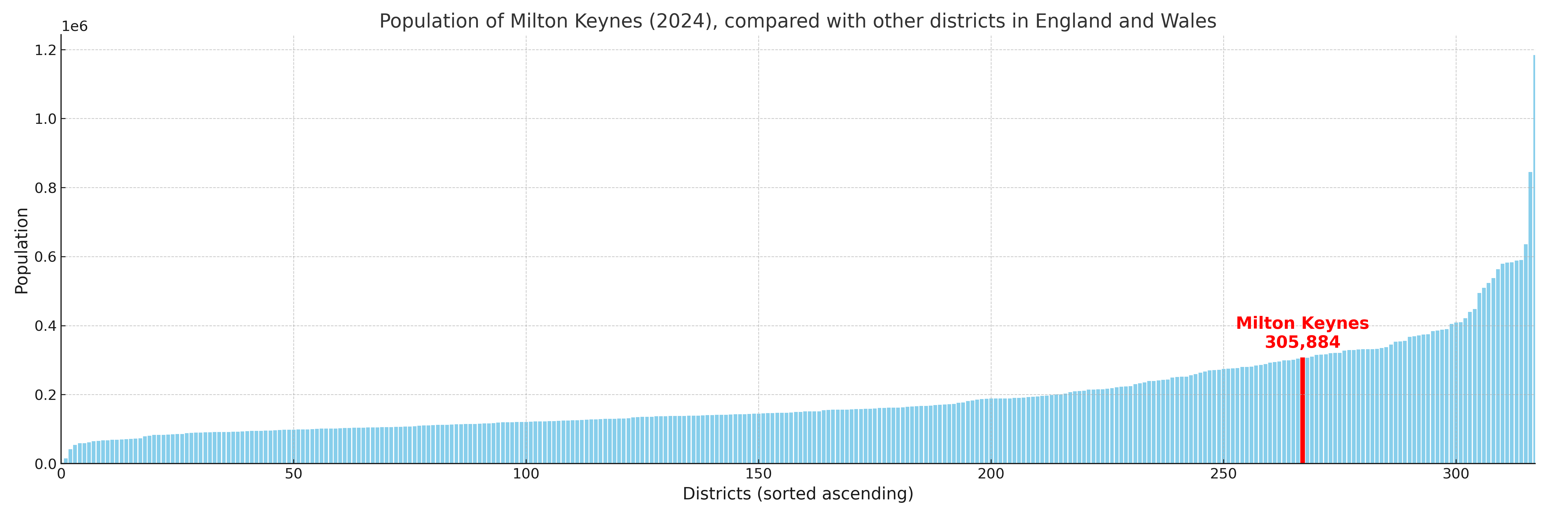
Milton Keynes compared with other districts in the UK
This section shows how Milton Keynes compares with other local authority districts in the UK, using a variety of measures and rankings.
Milton Keynes has 19 electoral wards.

Milton Keynes has a population of 305,884 (2024 mid-year estimate by ONS)
Population and Migration Trends in Milton Keynes
This chart shows the population trend for Milton Keynes from 2015 to 2024. It provides a quick overview of whether the local authority is growing, stable, or declining over time, and helps set context for the migration patterns shown below.
Population change is influenced by natural change (births minus deaths) and migration. The net migration chart below focuses on migration, separating internal migration (moves within the UK) from international migration (moves to and from abroad). Positive values indicate net inflows, while negative values indicate net outflows. The rate labels (per 1,000 residents) help compare migration intensity across years, even when the population size changes.
More local statistics and data for Milton Keynes can be found on the ONS statistics for Milton Keynes.
Latest news about Milton Keynes
Use the search box, or suggested search phrases, below to find recent news, council updates, planning stories, housing developments, transport changes, public services news, local elections, community issues and other local developments related to Milton Keynes. Results may include coverage from UK national, regional and local news websites, as well as official public-sector and local democracy sources.
- Milton Keynes council
- Milton Keynes planning
- Milton Keynes local elections
- Milton Keynes housing
- Milton Keynes transport
- Milton Keynes regeneration
- Milton Keynes public services