Test Valley
§ This page gives an overview of the Test Valley local authority district, bringing together key facts, maps, and data to help you quickly understand the area. This is one of 361 LAD profiles on Baseview.
Overview ⁞ Test Valley in western Hampshire is defined by the River Test, one of England’s most famous chalk streams, winding through meadows, villages, and farmland. Andover and Romsey are the main towns, with Romsey notable for its Norman abbey and markets. The countryside includes rolling hills, woodland, and parts of the North Wessex Downs and New Forest fringe. Villages with thatched cottages, mills, and historic estates add to the character of this picturesque district.
Test Valley Boundary Map
This map shows the official boundary of the Test Valley local authority district, based on the latest geographic data published by the Office for National Statistics (ONS). It provides a clear view of the district’s extent and helps you understand how the area fits within the wider regional and national landscape.
Contains OS data © Crown copyright and database right 2025. Source: Office for National Statistics licensed under the Open Government Licence v3.0.
The administrative boundary of Test Valley can also be viewed on OpenStreetMap: District Boundary of Test Valley.
Key Facts about Test Valley
What region is Test Valley in? Test Valley is in the South East of England, a region within the UK.
What county is Test Valley in? Test Valley is located in the county of Hampshire.
Is Test Valley a city? No, Test Valley is not a city. (Note: the UK has 76 officially designated cities.)
Who governs Test Valley? The local authority for this district is: Test Valley Borough Council - responsible for district-level services. Since Hampshire is a two-tier area, county-level services are handled by: Hampshire County Council.
▶ Official website of Test Valley Borough Council 🔗 testvalley.gov.uk
Which police force covers Test Valley? Policing in Test Valley is provided by Hampshire Constabulary 🔗 hampshire.police.uk, which serves 14 local authority districts: Basingstoke and Deane ⁞ East Hampshire ⁞ Eastleigh ⁞ Fareham ⁞ Gosport ⁞ Hart ⁞ Havant ⁞ Isle of Wight ⁞ New Forest ⁞ Portsmouth ⁞ Rushmoor ⁞ Southampton ⁞ Test Valley ⁞ Winchester.
Constituencies in Test Valley
Test Valley is divided into 3 parliamentary constituencies, listed below in alphabetical order.
A constituency is a specific geographical area that elects one Member of Parliament (MP) to represent them in the House of Commons. The United Kingdom is divided into 650 parliamentary constituencies. We have this list page for easy browsing of all UK parliamentary constituencies: List of Constituencies.
Wards in Test Valley
Test Valley is divided into 20 wards, listed below in alphabetical order.
- Ampfield & Braishfield
- Andover Downlands
- Andover Harroway
- Andover Millway
- Andover Romans
- Andover St Mary's
- Andover Winton
- Anna
- Bellinger
- Blackwater
- Bourne Valley
- Charlton & the Pentons
- Chilworth, Nursling & Rownhams
- Harewood
- Mid Test
- North Baddesley
- Romsey Abbey
- Romsey Cupernham
- Romsey Tadburn
- Valley Park
In the UK, a ward is a subdivision of a local authority area, used mainly for electoral and statistical purposes. Defined by the ONS, wards represent the primary unit for local elections, each returning one or more councillors to the local council. Wards are also used as a key geography for presenting population and census data. We have this list page for easy browsing of all electoral wards: List of all Electoral Wards in the UK.
Parishes in Test Valley
Test Valley is fully parished: 58 civil parishes, listed A-Z below.
- Abbotts Ann
- Ampfield
- Amport
- Andover
- Appleshaw
- Ashley
- Awbridge
- Barton Stacey
- Bossington
- Braishfield
- Broughton
- Buckholt
- Bullington
- Charlton
- Chilbolton
- Chilworth
- East Dean
- East Tytherley
- Enham Alamein
- Faccombe
- Frenchmoor
- Fyfield
- Goodworth Clatford
- Grateley
- Houghton
- Hurstbourne Tarrant
- Kimpton
- Kings Somborne
- Leckford
- Linkenholt
- Little Somborne
- Lockerley
- Longparish
- Longstock
- Melchet Park and Plaitford
- Michelmersh and Timsbury
- Monxton
- Mottisfont
- Nether Wallop
- North Baddesley
- Nursling and Rownhams
- Over Wallop
- Penton Grafton
- Penton Mewsey
- Quarley
- Romsey
- Sherfield English
- Shipton Bellinger
- Smannell
- Stockbridge
- Tangley
- Thruxton
- Upper Clatford
- Valley Park
- Vernhams Dean
- Wellow
- West Tytherley
- Wherwell
A civil parish is the lowest tier of local government in England, used for villages, small towns, and suburbs. They have their own local authority, either a parish council or a parish meeting, which provides local services like managing parks, allotments, and streetlights, and represents the community's views to larger councils.
We have this list page for easy browsing of all parishes: List of Civil Parishes in England and Wales.
Post Towns in Test Valley
Below is a list of post towns in Test Valley, grouped by postcode area:
- SO ▸ Romsey (SO51) ⁞ Stockbridge (SO20)
- SP ▸ Andover (SP10 / SP11)
The UK postal hierarchy begins with broad postcode areas (such as “CB” or “M”), which are divided into smaller postcode districts (such as “CB8” or “M1”) to support accurate mail routing. Each postal address is anchored by a designated post town, the official locality name used in the UK postcode system, which operates independently from Local Authority Districts —the administrative boundaries used for council tax and local government services. Because they serve different purposes, a property’s postal address and its local authority district do not always align exactly.
Built-up Areas in Test Valley
Test Valley covers 51 built-up areas, listed below in alphabetical order.
- Abbotts Ann
- Andover
- Anna Valley and Upper Clatford
- Appleshaw
- Awbridge
- Barton Stacey
- Belbins
- Blackhill *
- Braishfield
- Broughton (Test Valley)
- Chandler's Ford *
- Charlton (Test Valley)
- Chilbolton
- Chilworth (Test Valley) *
- East Wellow *
- Eastleigh *
- Enham Alamein
- Goodworth Clatford
- Houghton (Test Valley)
- Hurstbourne Tarrant
- Kentsboro
- King's Somborne
- Longstock
- Ludgershall (Wiltshire) *
- Middle Wallop
- Monxton
- Nether Wallop
- Newtown (Test Valley)
- North Baddesley
- Over Wallop
- Palestine
- Penton Mewsey and Penton Grafton
- Picket Piece *
- Plaitford *
- Red Rice
- Romsey
- Rownhams and Nursling *
- Shipton Bellinger
- Shootash
- Southampton *
- Stockbridge
- Sutton Scotney *
- Thruxton
- Timsbury (Test Valley)
- Totton *
- Vernham Street and Little Down
- West Dean (Test Valley) *
- West Tytherley
- West Wellow *
- Weyhill
- Wherwell
In the UK, a Built-up Area (BUA) is a continuous urban area of at least 20 hectares (0.2 km²), defined by the ONS as land where buildings are generally no more than 200 metres apart, such as towns, cities, or large villages. (Note: A BUA name marked with an asterisk (*) indicates that the area is situated partly in the district of Test Valley.)
We have this list page for easy browsing of all built-up areas: List of all Built-up Areas in GB.
Railway Stations in Test Valley
Test Valley is served by a number of National Rail stations, providing rail connections to nearby towns, cities, and destinations across Great Britain. The railway stations listed below are located within the Test Valley Local Authority District and are grouped by train operating company for clarity.
- Great Western Railway ▸ Romsey (SO51 8DU) ⁞ Mottisfont and Dunbridge (SO51 0LH)
- South Western Railway ▸ Andover (SP10 3HW) ⁞ Grateley (SP11 7EB)
This is a district-level view only. For a complete list of all National Rail stations across Great Britain, see the UK National Rail Stations Directory.
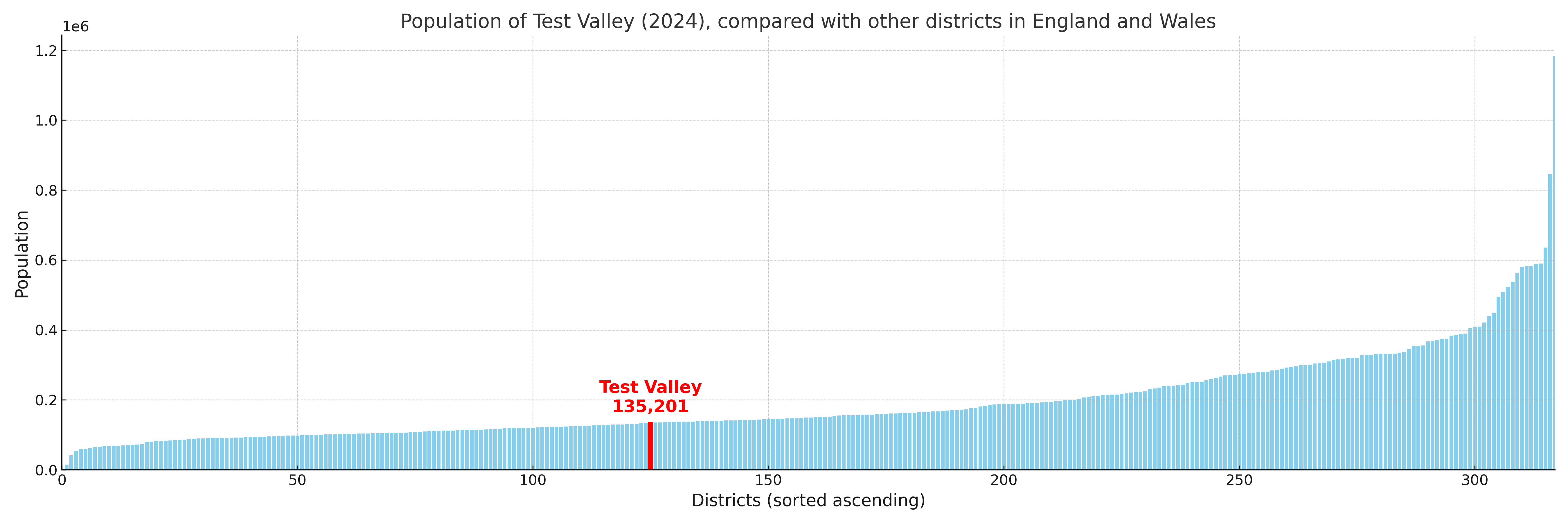
Test Valley compared with other districts in the UK
This section shows how Test Valley compares with other local authority districts in the UK, using a variety of measures and rankings.
Test Valley has 20 electoral wards.

Test Valley has a population of 135,201 (2024 mid-year estimate by ONS)
Population and Migration Trends in Test Valley
This chart shows the population trend for Test Valley from 2015 to 2024. It provides a quick overview of whether the local authority is growing, stable, or declining over time, and helps set context for the migration patterns shown below.
Population change is influenced by natural change (births minus deaths) and migration. The net migration chart below focuses on migration, separating internal migration (moves within the UK) from international migration (moves to and from abroad). Positive values indicate net inflows, while negative values indicate net outflows. The rate labels (per 1,000 residents) help compare migration intensity across years, even when the population size changes.
More local statistics and data for Test Valley can be found on the ONS statistics for Test Valley.
Latest news about Test Valley
Use the search box, or suggested search phrases, below to find recent news, council updates, planning stories, housing developments, transport changes, public services news, local elections, community issues and other local developments related to Test Valley. Results may include coverage from UK national, regional and local news websites, as well as official public-sector and local democracy sources.
- Test Valley council
- Test Valley planning
- Test Valley local elections
- Test Valley housing
- Test Valley transport
- Test Valley regeneration
- Test Valley public services