Wales
§ This page provides an overview of UK's Wales region, with key facts and data. Last updated on .
Overview ⁞ Wales, located to the west of England on the island of Great Britain, is celebrated for its rugged mountains, sweeping coastlines, and rich cultural heritage. The country is home to Snowdonia National Park (Eryri), the Brecon Beacons (Bannau Brycheiniog), and over 600 castles — more per square mile than anywhere else in the world. Its capital, Cardiff, is a vibrant centre for government, sport, and culture. Welsh identity is deeply rooted in the Welsh language, music, and festivals such as the Eisteddfod.
Wales is one of the four nations of the United Kingdom and has a devolved government — the Senedd Cymru/Welsh Parliament — in Cardiff, which has powers over areas such as health, education, transport, and local government. Administratively, Wales is divided into 22 local authorities, covering both densely populated urban areas and extensive rural regions. From the industrial heritage of the South Wales Valleys to the scenic landscapes of Pembrokeshire and Anglesey, each area has its own distinct character.
Principal areas of Wales
The 22 local authorities in Wales are single-tier councils responsible for all local services, including education, planning, social services, and waste management. They range from large cities such as Cardiff, Swansea, and Newport to rural counties like Powys and Ceredigion.
- Blaenau Gwent
- Bridgend
- Caerphilly
- Cardiff
- Carmarthenshire
- Ceredigion
- Conwy
- Denbighshire
- Flintshire
- Gwynedd
- Isle of Anglesey
- Merthyr Tydfil
- Monmouthshire
- Neath Port Talbot
- Newport
- Pembrokeshire
- Powys
- Rhondda Cynon Taf
- Swansea
- Torfaen
- Vale of Glamorgan
- Wrexham
Cities in Wales
Wales is home to several officially designated cities, each holding city status by royal charter rather than population size alone. Below is a complete list of cities in the region, including their local authorities, administrative geography, ceremonial honours, and the year city status was granted.
Cardiff
- Principal council
- Cardiff (Principal area)
- Civic honour
- Lord Mayor
- City status granted
- 1905
Swansea
- Principal council
- Swansea (Principal area)
- Civic honour
- Lord Mayor
- City status granted
- 1969
Bangor community
- Principal council
- Gwynedd (Principal area)
- City council (status holder)
- Bangor community
- Civic honour
- No additional civic honour
- City status granted
- 1974
St Davids and the Cathedral Close
- Principal council
- Pembrokeshire (Principal area)
- City council (status holder)
- St Davids and the Cathedral Close
- Civic honour
- No additional civic honour
- City status granted
- 1994
Newport
- Principal council
- Newport (Principal area)
- Civic honour
- No additional civic honour
- City status granted
- 2002
St Asaph community
- Principal council
- Denbighshire (Principal area)
- City council (status holder)
- St Asaph community
- Civic honour
- No additional civic honour
- City status granted
- 2012
Wrexham County Borough
- Principal council
- Wrexham (Principal area)
- Civic honour
- No additional civic honour
- City status granted
- 2022
Post Towns in Wales
Below is a complete list of post towns in Wales, grouped by postcode area to make browsing easier.
- CF ▸ Aberdare ⁞ Bargoed ⁞ Barry ⁞ Bridgend ⁞ Caerphilly ⁞ Cardiff ⁞ Cowbridge ⁞ Dinas Powys ⁞ Ferndale ⁞ Hengoed ⁞ Llantwit Major ⁞ Maesteg ⁞ Merthyr Tydfil ⁞ Mountain Ash ⁞ Penarth ⁞ Pentre ⁞ Pontyclun ⁞ Pontypridd ⁞ Porth ⁞ Porthcawl ⁞ Tonypandy ⁞ Treharris ⁞ Treorchy
- CH ▸ Bagillt ⁞ Birkenhead ⁞ Buckley ⁞ Chester ⁞ Deeside ⁞ Ellesmere Port ⁞ Flint ⁞ Holywell ⁞ Mold ⁞ Neston ⁞ Prenton ⁞ Wallasey ⁞ Wirral
- HR ▸ Bromyard ⁞ Hereford ⁞ Kington ⁞ Ledbury ⁞ Leominster ⁞ Ross-on-Wye
- LD ▸ Brecon ⁞ Builth Wells ⁞ Knighton ⁞ Llandrindod Wells ⁞ Llangammarch Wells ⁞ Llanwrtyd Wells ⁞ Presteigne ⁞ Rhayader
- LL ▸ Aberdyfi ⁞ Abergele ⁞ Amlwch ⁞ Arthog ⁞ Bala ⁞ Bangor ⁞ Barmouth ⁞ Beaumaris ⁞ Betws-y-Coed ⁞ Blaenau Ffestiniog ⁞ Bodorgan ⁞ Brynteg ⁞ Caernarfon ⁞ Cemaes Bay ⁞ Colwyn Bay ⁞ Conwy ⁞ Corwen ⁞ Criccieth ⁞ Denbigh ⁞ Dolgellau ⁞ Dolwyddelan ⁞ Dulas ⁞ Dyffryn Ardudwy ⁞ Fairbourne ⁞ Gaerwen ⁞ Garndolbenmaen ⁞ Harlech ⁞ Holyhead ⁞ Llanbedr ⁞ Llanbedrgoch ⁞ Llandudno ⁞ Llandudno Junction ⁞ Llanerchymedd ⁞ Llanfairfechan ⁞ Llanfairpwllgwyngyll ⁞ Llangefni ⁞ Llangollen ⁞ Llanrwst ⁞ Llwyngwril ⁞ Marianglas ⁞ Menai Bridge ⁞ Moelfre ⁞ Penmaenmawr ⁞ Penrhyndeudraeth ⁞ Pentraeth ⁞ Penysarn ⁞ Porthmadog ⁞ Prestatyn ⁞ Pwllheli ⁞ Rhosgoch ⁞ Rhosneigr ⁞ Rhyl ⁞ Ruthin ⁞ St. Asaph ⁞ Talsarnau ⁞ Talybont ⁞ Trefriw ⁞ Ty Croes ⁞ Tyn-y-Gongl ⁞ Tywyn ⁞ Wrexham ⁞ Y Felinheli
- NP ▸ Abergavenny ⁞ Abertillery ⁞ Blackwood ⁞ Caldicot ⁞ Chepstow ⁞ Crickhowell ⁞ Cwmbran ⁞ Ebbw Vale ⁞ Monmouth ⁞ New Tredegar ⁞ Newport ⁞ Pontypool ⁞ Tredegar ⁞ Usk
- SA ▸ Aberaeron ⁞ Ammanford ⁞ Boncath ⁞ Burry Port ⁞ Cardigan ⁞ Carmarthen ⁞ Clarbeston Road ⁞ Clynderwen ⁞ Crymych ⁞ Ferryside ⁞ Fishguard ⁞ Glogue ⁞ Goodwick ⁞ Haverfordwest ⁞ Kidwelly ⁞ Kilgetty ⁞ Lampeter ⁞ Llanarth ⁞ Llandeilo ⁞ Llandovery ⁞ Llandysul ⁞ Llanelli ⁞ Llanfyrnach ⁞ Llangadog ⁞ Llanwrda ⁞ Llanybydder ⁞ Milford Haven ⁞ Narberth ⁞ Neath ⁞ New Quay ⁞ Newcastle Emlyn ⁞ Newport ⁞ Pembroke ⁞ Pembroke Dock ⁞ Pencader ⁞ Port Talbot ⁞ Saundersfoot ⁞ Swansea ⁞ Tenby ⁞ Whitland
- SY ▸ Aberystwyth ⁞ Bishops Castle ⁞ Borth ⁞ Bow Street ⁞ Bucknell ⁞ Caersws ⁞ Church Stretton ⁞ Craven Arms ⁞ Ellesmere ⁞ Llanbrynmair ⁞ Llandinam ⁞ Llanfechain ⁞ Llanfyllin ⁞ Llanidloes ⁞ Llanon ⁞ Llanrhystud ⁞ Llansantffraid ⁞ Llanymynech ⁞ Ludlow ⁞ Lydbury North ⁞ Machynlleth ⁞ Malpas ⁞ Meifod ⁞ Montgomery ⁞ Newtown ⁞ Oswestry ⁞ Shrewsbury ⁞ Tregaron ⁞ Welshpool ⁞ Whitchurch ⁞ Ystrad Meurig
International Territorial Levels in Wales Region
The International Territorial Levels (ITLs) are a hierarchical system of geographic boundaries used for statistical purposes, specifically for regional data analysis and international comparisons. It has three levels: ITL1, ITL2, and ITL3, with ITL1 being the broadest level and ITL3 the most detailed.
Wales Region is one of ITL 1 areas in the UK. It is then divided ino the following ITL 2 areas (names in bold letters) and ITL 3 areas.
- North Wales — Isle of Anglesey ⁞ Gwynedd ⁞ Conwy and Denbighshire ⁞ Flintshire and Wrexham
- Mid and South West Wales — Mid Wales ⁞ South West Wales ⁞ Swansea ⁞ Neath Port Talbot
- South East Wales — Central Valleys and Bridgend ⁞ Cardiff and Vale of Glamorgan ⁞ Gwent Valleys ⁞ Monmouthshire and Newport
Constituencies in Wales
Wales has 32 parliamentary constituencies, encompassing urban, suburban, and rural areas. These range from the capital city of Cardiff to small towns and agricultural communities in mid and north Wales. Welsh politics features a mix of UK-wide parties and those with a specific focus on Wales, including Plaid Cymru.
- Aberafan Maesteg
- Alyn and Deeside
- Bangor Aberconwy
- Blaenau Gwent and Rhymney
- Brecon, Radnor and Cwm Tawe
- Bridgend
- Caerfyrddin
- Caerphilly
- Cardiff East
- Cardiff North
- Cardiff South and Penarth
- Cardiff West
- Ceredigion Preseli
- Clwyd East
- Clwyd North
- Dwyfor Meirionnydd
- Gower
- Llanelli
- Merthyr Tydfil and Aberdare
- Mid and South Pembrokeshire
- Monmouthshire
- Montgomeryshire and Glyndwr
- Neath and Swansea East
- Newport East
- Newport West and Islwyn
- Pontypridd
- Rhondda and Ogmore
- Swansea West
- Torfaen
- Vale of Glamorgan
- Wrexham
- Ynys Môn
Population of Wales
Wales is home to approximately 3.13 million people (mid-2022, ONS). With an area of around 20,737 square kilometres (8,006 square miles), that translates to a population density of about 151 people per km².
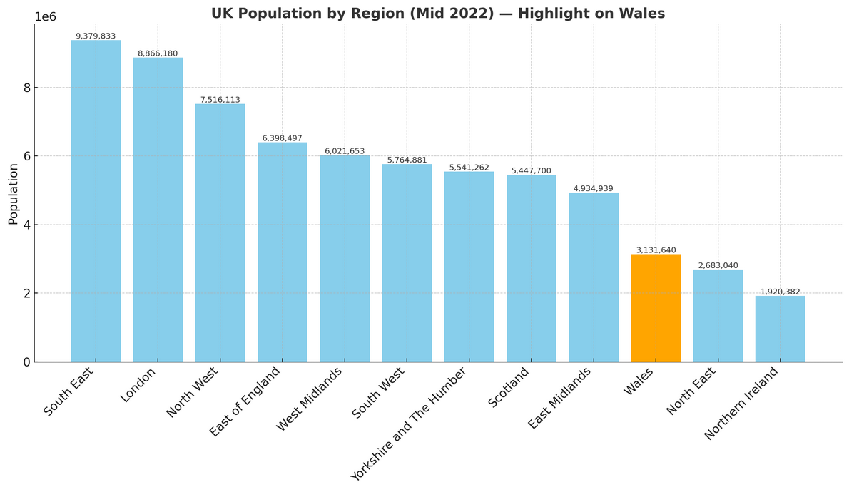
How it compares to the rest of UK
- Share of the population: Wales accounts for roughly 4.6% of the UK’s total population of 67.6 million.
- Population density: At 151 people per km², it is much less crowded than England’s average of 438 people per km², giving Wales a more spacious, rural feel overall.