West Midlands
§ This page provides an overview of UK's West Midlands region, with key facts and data. Last updated on .
Overview ⁞ The West Midlands is a diverse region at the heart of England, known for its manufacturing, automotive industry, and rich cultural heritage. It includes major urban centres like Birmingham, Coventry, and Wolverhampton, as well as historic market towns and scenic areas such as the Malvern Hills and Shropshire Hills.
The region includes the metropolitan county of West Midlands, containing several large cities governed by metropolitan boroughs, as well as rural counties like Shropshire, Staffordshire, Warwickshire, Worcestershire, and Herefordshire, which use two-tier or unitary local government structures.
Ceremonial Counties in West Midlands region
The West Midlands consists of 6 ceremonial counties: Herefordshire, Shropshire, Staffordshire, Warwickshire, West Midlands, and Worcestershire. The economy spans advanced manufacturing, education, logistics, and tourism.
Districts in West Midlands
The UK is divided into Local Authority Districts (LADs) as the main building blocks of local government and statistical geography. The following lists all the LADs in this region.
- Unitary Authorities ▸ Herefordshire, County of ⁞ Shropshire ⁞ Stoke-on-Trent ⁞ Telford and Wrekin
- Staffordshire ▸ Cannock Chase ⁞ East Staffordshire ⁞ Lichfield ⁞ Newcastle-under-Lyme ⁞ South Staffordshire ⁞ Stafford ⁞ Staffordshire Moorlands ⁞ Tamworth
- Warwickshire ▸ North Warwickshire ⁞ Nuneaton and Bedworth ⁞ Rugby ⁞ Stratford-on-Avon ⁞ Warwick
- West Midlands ▸ Birmingham ⁞ Coventry ⁞ Dudley ⁞ Sandwell ⁞ Solihull ⁞ Walsall ⁞ Wolverhampton
- Worcestershire ▸ Bromsgrove ⁞ Malvern Hills ⁞ Redditch ⁞ Worcester ⁞ Wychavon ⁞ Wyre Forest
Cities in West Midlands
West Midlands is home to several officially designated cities, each holding city status by royal charter rather than population size alone. Below is a complete list of cities in the region, including their local authorities, administrative geography, ceremonial honours, and the year city status was granted.
City of Worcester
- Local authority
- Worcester (Non-metropolitan borough)
- Ceremonial county
- Worcestershire
- Civic honour
- No additional civic honour
- City status granted
- 1189
City of Coventry
- Local authority
- Coventry (Metropolitan borough)
- Ceremonial county
- West Midlands
- Civic honour
- Lord Mayor
- City status granted
- 1345
City of Birmingham
- Local authority
- Birmingham (Metropolitan borough)
- Ceremonial county
- West Midlands
- Civic honour
- Lord Mayor
- City status granted
- 1889
City of Stoke-on-Trent
- Local authority
- Stoke-on-Trent (Unitary authority)
- Ceremonial county
- Staffordshire
- Civic honour
- Lord Mayor
- City status granted
- 1925
Lichfield parish
- Local authority
- Lichfield (Unitary Authority)
- City council (status holder)
- Lichfield parish (Civil parish)
- Ceremonial county
- Staffordshire
- Civic honour
- No additional civic honour
- City status granted
- 1980
Hereford parish
- Local authority
- Herefordshire, County of (Unitary Authority)
- City council (status holder)
- Hereford parish (Civil parish)
- Ceremonial county
- Herefordshire
- Civic honour
- No additional civic honour
- City status granted
- 2000
City of Wolverhampton
- Local authority
- Wolverhampton (Metropolitan borough)
- Ceremonial county
- West Midlands
- Civic honour
- No additional civic honour
- City status granted
- 2000
Post Towns in West Midlands
Below is a complete list of post towns in West Midlands, grouped by postcode area to make browsing easier.
- B ▸ Alcester ⁞ Birmingham ⁞ Bromsgrove ⁞ Cradley Heath ⁞ Halesowen ⁞ Henley-in-Arden ⁞ Oldbury ⁞ Redditch ⁞ Rowley Regis ⁞ Smethwick ⁞ Solihull ⁞ Studley ⁞ Sutton Coldfield ⁞ Tamworth ⁞ West Bromwich
- CV ▸ Atherstone ⁞ Bedworth ⁞ Coventry ⁞ Kenilworth ⁞ Leamington Spa ⁞ Nuneaton ⁞ Rugby ⁞ Shipston-on-Stour ⁞ Southam ⁞ Stratford-upon-Avon ⁞ Warwick
- DE ▸ Alfreton ⁞ Ashbourne ⁞ Bakewell ⁞ Belper ⁞ Burton-on-Trent ⁞ Derby ⁞ Heanor ⁞ Ilkeston ⁞ Matlock ⁞ Ripley ⁞ Swadlincote
- DY ▸ Bewdley ⁞ Brierley Hill ⁞ Dudley ⁞ Kidderminster ⁞ Kingswinford ⁞ Stourbridge ⁞ Stourport-on-Severn ⁞ Tipton
- ST ▸ Leek ⁞ Newcastle ⁞ Stafford ⁞ Stoke-on-Trent ⁞ Stone ⁞ Uttoxeter
- TF ▸ Broseley ⁞ Market Drayton ⁞ Much Wenlock ⁞ Newport ⁞ Shifnal ⁞ Telford
- WR ▸ Broadway ⁞ Droitwich ⁞ Evesham ⁞ Malvern ⁞ Pershore ⁞ Tenbury Wells ⁞ Worcester
- WS ▸ Burntwood ⁞ Cannock ⁞ Lichfield ⁞ Rugeley ⁞ Walsall ⁞ Wednesbury
- WV ▸ Bilston ⁞ Bridgnorth ⁞ Willenhall ⁞ Wolverhampton
International Territorial Levels in West Midlands Region
The International Territorial Levels (ITLs) are a hierarchical system of geographic boundaries used for statistical purposes, specifically for regional data analysis and international comparisons. It has three levels: ITL1, ITL2, and ITL3, with ITL1 being the broadest level and ITL3 the most detailed.
West Midlands Region is one of ITL 1 areas in the UK. It is then divided ino the following ITL 2 areas (names in bold letters) and ITL 3 areas.
- Herefordshire, Worcestershire and Warwickshire — Herefordshire, County of ⁞ Worcestershire CC ⁞ Warwickshire CC
- Shropshire and Staffordshire — Telford and Wrekin ⁞ Shropshire ⁞ Stoke-on-Trent ⁞ Staffordshire CC
- West Midlands — Birmingham ⁞ Solihull ⁞ Coventry ⁞ Dudley ⁞ Sandwell ⁞ Walsall ⁞ Wolverhampton
Constituencies in West Midlands
There are 59 parliamentary constituencies in the West Midlands, ranging from urban seats in Birmingham and Coventry to rural areas in Shropshire and Herefordshire. Political debates often focus on infrastructure, jobs, and regional investment.
- Aldridge-Brownhills
- Birmingham Edgbaston
- Birmingham Erdington
- Birmingham Hall Green and Moseley
- Birmingham Hodge Hill and Solihull North
- Birmingham Ladywood
- Birmingham Northfield
- Birmingham Perry Barr
- Birmingham Selly Oak
- Birmingham Yardley
- Bromsgrove
- Burton and Uttoxeter
- Cannock Chase
- Coventry East
- Coventry North West
- Coventry South
- Droitwich and Evesham
- Dudley
- Halesowen
- Hereford and South Herefordshire
- Kenilworth and Southam
- Kingswinford and South Staffordshire
- Lichfield
- Meriden and Solihull East
- Newcastle-under-Lyme
- North Herefordshire
- North Shropshire
- North Warwickshire and Bedworth
- Nuneaton
- Redditch
- Rugby
- Shrewsbury
- Smethwick
- Solihull West and Shirley
- South Shropshire
- Stafford
- Staffordshire Moorlands
- Stoke-on-Trent Central
- Stoke-on-Trent North
- Stoke-on-Trent South
- Stone, Great Wyrley and Penkridge
- Stourbridge
- Stratford-on-Avon
- Sutton Coldfield
- Tamworth
- Telford
- The Wrekin
- Tipton and Wednesbury
- Walsall and Bloxwich
- Warwick and Leamington
- West Bromwich
- West Worcestershire
- Wolverhampton North East
- Wolverhampton South East
- Wolverhampton West
- Worcester
- Wyre Forest
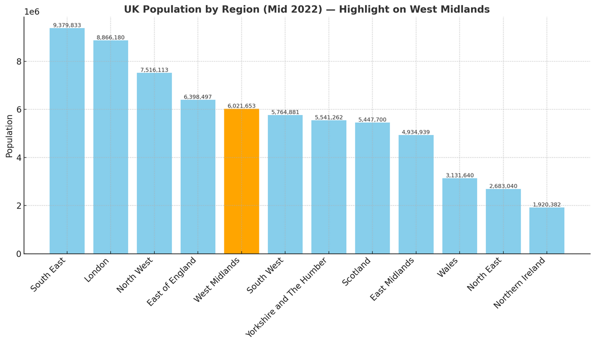
Population of The West Midlands
The West Midlands is home to just over 6 million people (mid-2022, ONS). Covering 12,998 square kilometres (5,019 square miles), the region has a population density of 463 people per square kilometre.
How it compares to the rest of England
- Population share: The West Midlands makes up 10.5% of England’s 57.1 million residents, ranking 5th out of 9 regions by population size.
- Population density: With 463 people per km², the region is slightly more crowded than the national average of 438 people per km²—25 more people per km²—placing it 4th out of 9 regions for density.