East of England
§ This page provides an overview of UK's East of England region, with key facts and data. Last updated on .
Overview ⁞ The East of England is a largely rural region known for its fertile farmland, historic cities, and long North Sea coastline. It includes world-famous sites such as Cambridge University and the coastal resorts of Great Yarmouth and Southend-on-Sea. The region’s flat fenland landscapes, market towns, and strong commuter links to London make it a popular area for both living and tourism. Its economy is diverse, spanning agriculture, technology, education, and financial services.
The region stretches from the fenlands of Cambridgeshire to the coastal areas of Norfolk, Suffolk, and Essex. It has a combination of two-tier counties and unitary authorities shaped by local government reforms. Proximity to London has encouraged the growth of commuter towns and infrastructure improvements, while traditional county identities remain strong.
Ceremonial Counties in East of England region
The East of England comprises six ceremonial counties: Bedfordshire, Cambridgeshire, Essex, Hertfordshire, Norfolk, and Suffolk. Each offers a distinct blend of landscapes and economies, from the farmland of Norfolk to the urban centres of Luton, Chelmsford, and Cambridge.
Districts in East of England
The UK is divided into Local Authority Districts (LADs) as the main building blocks of local government and statistical geography. The following lists all the LADs in this region.
- Unitary Authorities ▸ Bedford ⁞ Central Bedfordshire ⁞ Luton ⁞ Peterborough ⁞ Southend-on-Sea ⁞ Thurrock
- Cambridgeshire ▸ Cambridge ⁞ East Cambridgeshire ⁞ Fenland ⁞ Huntingdonshire ⁞ South Cambridgeshire
- Essex ▸ Basildon ⁞ Braintree ⁞ Brentwood ⁞ Castle Point ⁞ Chelmsford ⁞ Colchester ⁞ Epping Forest ⁞ Harlow ⁞ Maldon ⁞ Rochford ⁞ Tendring ⁞ Uttlesford
- Hertfordshire ▸ Broxbourne ⁞ Dacorum ⁞ East Hertfordshire ⁞ Hertsmere ⁞ North Hertfordshire ⁞ St Albans ⁞ Stevenage ⁞ Three Rivers ⁞ Watford ⁞ Welwyn Hatfield
- Norfolk ▸ Breckland ⁞ Broadland ⁞ Great Yarmouth ⁞ King's Lynn and West Norfolk ⁞ North Norfolk ⁞ Norwich ⁞ South Norfolk
- Suffolk ▸ Babergh ⁞ East Suffolk ⁞ Ipswich ⁞ Mid Suffolk ⁞ West Suffolk
Cities in East of England
East of England is home to several officially designated cities, each holding city status by royal charter rather than population size alone. Below is a complete list of cities in the region, including their local authorities, administrative geography, ceremonial honours, and the year city status was granted.
City of Peterborough
- Local authority
- Peterborough (Unitary authority)
- Ceremonial county
- Cambridgeshire
- Civic honour
- No additional civic honour
- City status granted
- 1541
St Albans City and District
- Local authority
- St Albans (Non-metropolitan borough)
- Ceremonial county
- Hertfordshire
- Civic honour
- No additional civic honour
- City status granted
- 1877
City of Cambridge
- Local authority
- Cambridge (Non-metropolitan borough)
- Ceremonial county
- Cambridgeshire
- Civic honour
- No additional civic honour
- City status granted
- 1951
Ely parish
- Local authority
- East Cambridgeshire (Unitary Authority)
- City council (status holder)
- Ely parish (Civil parish)
- Ceremonial county
- Cambridgeshire
- Civic honour
- No additional civic honour
- City status granted
- 1974
City of Norwich
- Local authority
- Norwich (Non-metropolitan borough)
- Ceremonial county
- Norfolk
- Civic honour
- Lord Mayor
- City status granted
- 1974
City of Chelmsford
- Local authority
- Chelmsford (Non-metropolitan borough)
- Ceremonial county
- Essex
- Civic honour
- No additional civic honour
- City status granted
- 2012
City of Colchester
- Local authority
- Colchester (Non-metropolitan borough)
- Ceremonial county
- Essex
- Civic honour
- No additional civic honour
- City status granted
- 2022
City of Southend-on-Sea
- Local authority
- Southend-on-Sea (Unitary authority)
- Ceremonial county
- Essex
- Civic honour
- No additional civic honour
- City status granted
- 2022
Post Towns in East of England
Below is a complete list of post towns in East of England, grouped by postcode area to make browsing easier.
- AL ▸ Harpenden ⁞ Hatfield ⁞ St. Albans ⁞ Welwyn ⁞ Welwyn Garden City
- CB ▸ Cambridge ⁞ Ely ⁞ Haverhill ⁞ Newmarket ⁞ Saffron Walden
- CM ▸ Billericay ⁞ Bishop's Stortford ⁞ Braintree ⁞ Brentwood ⁞ Burnham-on-Crouch ⁞ Chelmsford ⁞ Dunmow ⁞ Epping ⁞ Harlow ⁞ Ingatestone ⁞ Maldon ⁞ Ongar ⁞ Sawbridgeworth ⁞ Southminster ⁞ Stansted ⁞ Witham
- CO ▸ Bures ⁞ Clacton-on-Sea ⁞ Colchester ⁞ Frinton-on-Sea ⁞ Halstead ⁞ Harwich ⁞ Manningtree ⁞ Sudbury ⁞ Walton-on-the-Naze
- EN ▸ Barnet ⁞ Broxbourne ⁞ Enfield ⁞ Hoddesdon ⁞ Potters Bar ⁞ Waltham Abbey ⁞ Waltham Cross
- IP ▸ Aldeburgh ⁞ Brandon ⁞ Bury St. Edmunds ⁞ Diss ⁞ Eye ⁞ Felixstowe ⁞ Halesworth ⁞ Harleston ⁞ Ipswich ⁞ Leiston ⁞ Saxmundham ⁞ Southwold ⁞ Stowmarket ⁞ Thetford ⁞ Woodbridge
- NR ▸ Attleborough ⁞ Beccles ⁞ Bungay ⁞ Cromer ⁞ Dereham ⁞ Fakenham ⁞ Great Yarmouth ⁞ Holt ⁞ Lowestoft ⁞ Melton Constable ⁞ North Walsham ⁞ Norwich ⁞ Sheringham ⁞ Walsingham ⁞ Wells-next-the-Sea ⁞ Wymondham
- RM ▸ Dagenham ⁞ Grays ⁞ Hornchurch ⁞ Purfleet ⁞ Rainham ⁞ Romford ⁞ South Ockendon ⁞ Tilbury ⁞ Upminster
- SG ▸ Arlesey ⁞ Baldock ⁞ Biggleswade ⁞ Buntingford ⁞ Henlow ⁞ Hertford ⁞ Hitchin ⁞ Knebworth ⁞ Letchworth Garden City ⁞ Much Hadham ⁞ Royston ⁞ Sandy ⁞ Shefford ⁞ Stevenage ⁞ Ware
- SS ▸ Basildon ⁞ Benfleet ⁞ Canvey Island ⁞ Hockley ⁞ Leigh-on-Sea ⁞ Rayleigh ⁞ Rochford ⁞ Southend-on-Sea ⁞ Stanford-le-Hope ⁞ Westcliff-on-Sea ⁞ Wickford
- WD ▸ Abbots Langley ⁞ Borehamwood ⁞ Bushey ⁞ Kings Langley ⁞ Radlett ⁞ Rickmansworth ⁞ Watford
International Territorial Levels in East of England Region
The International Territorial Levels (ITLs) are a hierarchical system of geographic boundaries used for statistical purposes, specifically for regional data analysis and international comparisons. It has three levels: ITL1, ITL2, and ITL3, with ITL1 being the broadest level and ITL3 the most detailed.
East of England Region is one of ITL 1 areas in the UK. It is then divided ino the following ITL 2 areas (names in bold letters) and ITL 3 areas.
- Bedfordshire and Hertfordshire — Luton ⁞ Bedford ⁞ Central Bedfordshire ⁞ North and East Hertfordshire ⁞ South West Hertfordshire
- Essex — Southend-on-Sea ⁞ Thurrock ⁞ Essex Haven Gateway ⁞ West Essex ⁞ Heart of Essex ⁞ Essex Thames Gateway
- Cambridgeshire and Peterborough — Peterborough ⁞ Cambridgeshire CC
- Norfolk — Norwich and East Norfolk ⁞ North and West Norfolk ⁞ Breckland and South Norfolk
- Suffolk — Babergh and Mid Suffolk ⁞ Ipswich ⁞ East Suffolk ⁞ West Suffolk
Constituencies in East of England
The region contains 61 parliamentary constituencies, ranging from major urban centres such as Norwich, Luton, and Chelmsford to coastal resorts and rural districts. Many constituencies are shaped by commuter patterns to London, alongside strong agricultural and high-tech sectors.
- Basildon and Billericay
- Bedford
- Braintree
- Brentwood and Ongar
- Broadland and Fakenham
- Broxbourne
- Bury St Edmunds and Stowmarket
- Cambridge
- Castle Point
- Central Suffolk and North Ipswich
- Chelmsford
- Clacton
- Colchester
- Dunstable and Leighton Buzzard
- Ely and East Cambridgeshire
- Epping Forest
- Great Yarmouth
- Harlow
- Harpenden and Berkhamsted
- Harwich and North Essex
- Hemel Hempstead
- Hertford and Stortford
- Hertsmere
- Hitchin
- Huntingdon
- Ipswich
- Lowestoft
- Luton North
- Luton South and South Bedfordshire
- Maldon
- Mid Bedfordshire
- Mid Norfolk
- North Bedfordshire
- North East Cambridgeshire
- North East Hertfordshire
- North Norfolk
- North West Cambridgeshire
- North West Essex
- North West Norfolk
- Norwich North
- Norwich South
- Peterborough
- Rayleigh and Wickford
- South Basildon and East Thurrock
- South Cambridgeshire
- South Norfolk
- South Suffolk
- South West Hertfordshire
- South West Norfolk
- Southend East and Rochford
- Southend West and Leigh
- St Albans
- St Neots and Mid Cambridgeshire
- Stevenage
- Suffolk Coastal
- Thurrock
- Watford
- Waveney Valley
- Welwyn Hatfield
- West Suffolk
- Witham
Population of East England
East England is home to around 6.4 million people (mid-2022, ONS). Spanning 19,119 square kilometres (7,382 square miles), it has a population density of 335 people per square kilometre.
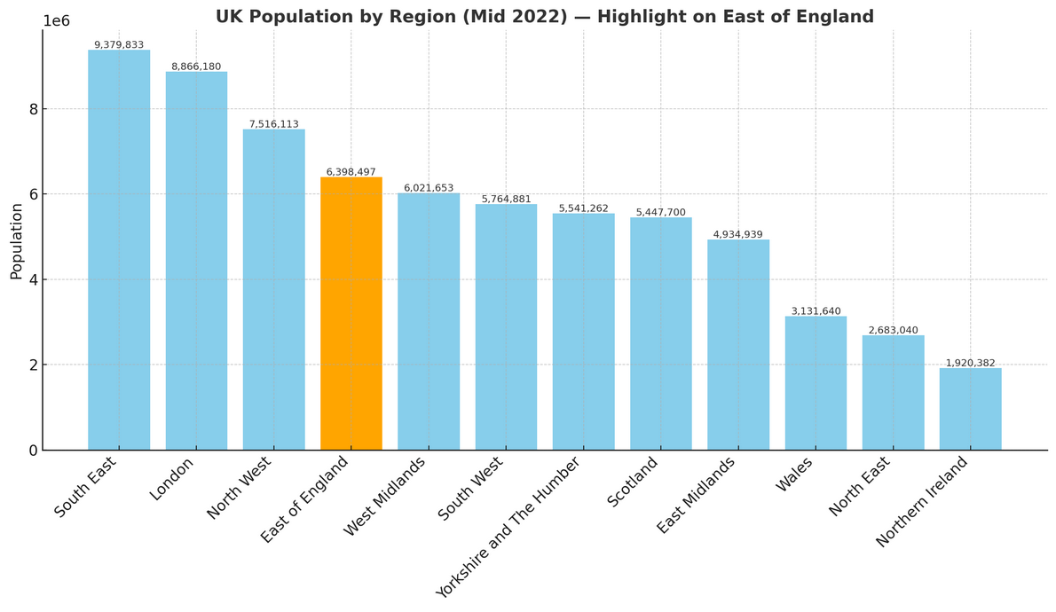
How it compares to the rest of England
- Population share: The region accounts for 11.2% of England’s 57.1 million residents, making it the 4th most populated of the nine English regions.
- Population density: With 335 people per km², East England is less crowded than the national average of 438 people per km²—103 fewer people per km². This places it 6th out of 9 regions for population density.