South West
§ This page provides an overview of UK's South West region, with key facts and data. Last updated on .
Overview ⁞ The South West of England is known for its coastlines, countryside, and heritage cities. It is home to Cornwall, Devon, Somerset, and Dorset, as well as Bath and Bristol. The region’s landscapes include the Jurassic Coast, Exmoor National Park, and Dartmoor National Park. Tourism, agriculture, and renewable energy are important economic drivers.
The South West features a mix of unitary authorities and two-tier county systems, with governance reflecting both historic boundaries and modern reforms. Rural areas dominate, but major urban centres provide economic and cultural hubs.
Ceremonial Counties in South West region
The South West consists of 7 ceremonial counties: Bristol, Cornwall (including the Isles of Scilly), Devon, Dorset, Gloucestershire, Somerset, and Wiltshire. The region offers a combination of rural tranquility, historic towns, and busy ports.
Districts in South West
The UK is divided into Local Authority Districts (LADs) as the main building blocks of local government and statistical geography. The following lists all the LADs in this region.
- Unitary Authorities ▸ Bath and North East Somerset ⁞ Bournemouth, Christchurch and Poole ⁞ Bristol, City of ⁞ Cornwall ⁞ Dorset ⁞ Isles of Scilly ⁞ North Somerset ⁞ Plymouth ⁞ Somerset ⁞ South Gloucestershire ⁞ Swindon ⁞ Torbay ⁞ Wiltshire
- Devon ▸ East Devon ⁞ Exeter ⁞ Mid Devon ⁞ North Devon ⁞ South Hams ⁞ Teignbridge ⁞ Torridge ⁞ West Devon
- Gloucestershire ▸ Cheltenham ⁞ Cotswold ⁞ Forest of Dean ⁞ Gloucester ⁞ Stroud ⁞ Tewkesbury
Cities in South West
South West is home to several officially designated cities, each holding city status by royal charter rather than population size alone. Below is a complete list of cities in the region, including their local authorities, administrative geography, ceremonial honours, and the year city status was granted.
City of Exeter
- Local authority
- Exeter (Non-metropolitan borough)
- Ceremonial county
- Devon
- Civic honour
- Lord Mayor
- City status granted
- 1050
Salisbury parish
- Local authority
- Wiltshire (Unitary Authority)
- City council (status holder)
- Salisbury parish (Civil parish)
- Ceremonial county
- Wiltshire
- Civic honour
- No additional civic honour
- City status granted
- 1227
City of Gloucester
- Local authority
- Gloucester (Non-metropolitan borough)
- Ceremonial county
- Gloucestershire
- Civic honour
- No additional civic honour
- City status granted
- 1541
City of Bristol
- Local authority
- Bristol, City of (Unitary authority; Ceremonial county)
- Ceremonial county
- Bristol
- Civic honour
- Lord Mayor
- City status granted
- 1542
Bath
- Local authority
- Bath and North East Somerset (Unitary Authority)
- City status holder
- Charter Trustees of the City of Bath (Charter trustees)
- Ceremonial county
- Somerset
- Civic honour
- No additional civic honour
- City status granted
- 1590
Truro parish
- Local authority
- Cornwall (Unitary Authority)
- City council (status holder)
- Truro parish (Civil parish)
- Ceremonial county
- Cornwall
- Civic honour
- No additional civic honour
- City status granted
- 1877
City of Plymouth
- Local authority
- Plymouth (Unitary authority)
- Ceremonial county
- Devon
- Civic honour
- Lord Mayor
- City status granted
- 1928
Wells parish
- Local authority
- Somerset (Unitary Authority)
- City council (status holder)
- Wells parish (Civil parish)
- Ceremonial county
- Somerset
- Civic honour
- No additional civic honour
- City status granted
- 1974
Post Towns in South West
Below is a complete list of post towns in South West, grouped by postcode area to make browsing easier.
- BA ▸ Bath ⁞ Bradford-on-Avon ⁞ Bruton ⁞ Castle Cary ⁞ Frome ⁞ Glastonbury ⁞ Radstock ⁞ Shepton Mallet ⁞ Street ⁞ Templecombe ⁞ Trowbridge ⁞ Warminster ⁞ Wells ⁞ Westbury ⁞ Wincanton ⁞ Yeovil
- BH ▸ Bournemouth ⁞ Broadstone ⁞ Christchurch ⁞ Ferndown ⁞ New Milton ⁞ Poole ⁞ Ringwood ⁞ Swanage ⁞ Verwood ⁞ Wareham ⁞ Wimborne
- BS ▸ Axbridge ⁞ Banwell ⁞ Bristol ⁞ Cheddar ⁞ Clevedon ⁞ Wedmore ⁞ Weston-super-Mare ⁞ Winscombe
- DT ▸ Beaminster ⁞ Blandford Forum ⁞ Bridport ⁞ Dorchester ⁞ Lyme Regis ⁞ Portland ⁞ Sherborne ⁞ Sturminster Newton ⁞ Weymouth
- EX ▸ Axminster ⁞ Barnstaple ⁞ Beaworthy ⁞ Bideford ⁞ Braunton ⁞ Bude ⁞ Budleigh Salterton ⁞ Chulmleigh ⁞ Colyton ⁞ Crediton ⁞ Cullompton ⁞ Dawlish ⁞ Exeter ⁞ Exmouth ⁞ Holsworthy ⁞ Honiton ⁞ Ilfracombe ⁞ Lynmouth ⁞ Lynton ⁞ North Tawton ⁞ Okehampton ⁞ Ottery St. Mary ⁞ Seaton ⁞ Sidmouth ⁞ South Molton ⁞ Tiverton ⁞ Torrington ⁞ Umberleigh ⁞ Winkleigh ⁞ Woolacombe
- GL ▸ Badminton ⁞ Berkeley ⁞ Blakeney ⁞ Cheltenham ⁞ Chipping Campden ⁞ Cinderford ⁞ Cirencester ⁞ Coleford ⁞ Drybrook ⁞ Dursley ⁞ Dymock ⁞ Fairford ⁞ Gloucester ⁞ Lechlade ⁞ Longhope ⁞ Lydbrook ⁞ Lydney ⁞ Mitcheldean ⁞ Moreton-in-Marsh ⁞ Newent ⁞ Newnham ⁞ Ruardean ⁞ Stonehouse ⁞ Stroud ⁞ Tetbury ⁞ Tewkesbury ⁞ Westbury-on-Severn ⁞ Wotton-under-Edge
- OX ▸ Abingdon ⁞ Bampton ⁞ Banbury ⁞ Bicester ⁞ Burford ⁞ Carterton ⁞ Chinnor ⁞ Chipping Norton ⁞ Didcot ⁞ Kidlington ⁞ Oxford ⁞ Thame ⁞ Wallingford ⁞ Wantage ⁞ Watlington ⁞ Witney ⁞ Woodstock
- PL ▸ Bodmin ⁞ Boscastle ⁞ Callington ⁞ Calstock ⁞ Camelford ⁞ Delabole ⁞ Fowey ⁞ Gunnislake ⁞ Ivybridge ⁞ Launceston ⁞ Lifton ⁞ Liskeard ⁞ Looe ⁞ Lostwithiel ⁞ Padstow ⁞ Par ⁞ Plymouth ⁞ Port Isaac ⁞ Saltash ⁞ St. Austell ⁞ Tavistock ⁞ Tintagel ⁞ Torpoint ⁞ Wadebridge ⁞ Yelverton
- SN ▸ Calne ⁞ Chippenham ⁞ Corsham ⁞ Devizes ⁞ Faringdon ⁞ Malmesbury ⁞ Marlborough ⁞ Melksham ⁞ Pewsey ⁞ Swindon
- SP ▸ Andover ⁞ Fordingbridge ⁞ Gillingham ⁞ Salisbury ⁞ Shaftesbury ⁞ Tidworth
- TA ▸ Bridgwater ⁞ Burnham-on-Sea ⁞ Chard ⁞ Crewkerne ⁞ Dulverton ⁞ Highbridge ⁞ Hinton St. George ⁞ Ilminster ⁞ Langport ⁞ Martock ⁞ Merriott ⁞ Minehead ⁞ Montacute ⁞ Somerton ⁞ South Petherton ⁞ Stoke-sub-Hamdon ⁞ Taunton ⁞ Watchet ⁞ Wellington
- TQ ▸ Brixham ⁞ Buckfastleigh ⁞ Dartmouth ⁞ Kingsbridge ⁞ Newton Abbot ⁞ Paignton ⁞ Salcombe ⁞ South Brent ⁞ Teignmouth ⁞ Torquay ⁞ Totnes
- TR ▸ Camborne ⁞ Falmouth ⁞ Hayle ⁞ Helston ⁞ Isles of Scilly ⁞ Marazion ⁞ Newquay ⁞ Penryn ⁞ Penzance ⁞ Perranporth ⁞ Redruth ⁞ St. Agnes ⁞ St. Columb ⁞ St. Ives ⁞ Truro
International Territorial Levels in South West Region
The International Territorial Levels (ITLs) are a hierarchical system of geographic boundaries used for statistical purposes, specifically for regional data analysis and international comparisons. It has three levels: ITL1, ITL2, and ITL3, with ITL1 being the broadest level and ITL3 the most detailed.
South West Region is one of ITL 1 areas in the UK. It is then divided ino the following ITL 2 areas (names in bold letters) and ITL 3 areas.
- Cornwall and Isles of Scilly — Cornwall and Isles of Scilly
- Devon — Plymouth ⁞ Torbay ⁞ Devon CC
- West of England — Bristol, City of ⁞ Bath & North East Somerset and South Gloucestershire
- North Somerset, Somerset and Dorset — North Somerset ⁞ Somerset ⁞ Bournemouth, Christchurch and Poole ⁞ Dorset
- Gloucestershire and Wiltshire — Swindon ⁞ Wiltshire ⁞ Gloucestershire CC
Constituencies in South West
There are 58 parliamentary constituencies in the South West, covering everything from coastal tourism hubs to agricultural heartlands. Issues such as housing, transport, and environmental protection are key to local politics.
- Bath
- Bournemouth East
- Bournemouth West
- Bridgwater
- Bristol Central
- Bristol East
- Bristol North East
- Bristol North West
- Bristol South
- Camborne and Redruth
- Central Devon
- Cheltenham
- Chippenham
- Christchurch
- East Wiltshire
- Exeter
- Exmouth and Exeter East
- Filton and Bradley Stoke
- Forest of Dean
- Frome and East Somerset
- Glastonbury and Somerton
- Gloucester
- Honiton and Sidmouth
- Melksham and Devizes
- Mid Dorset and North Poole
- Newton Abbot
- North Cornwall
- North Cotswolds
- North Devon
- North Dorset
- North East Somerset and Hanham
- North Somerset
- Plymouth Moor View
- Plymouth Sutton and Devonport
- Poole
- Salisbury
- South Cotswolds
- South Devon
- South Dorset
- South East Cornwall
- South West Devon
- South West Wiltshire
- St Austell and Newquay
- St Ives
- Stroud
- Swindon North
- Swindon South
- Taunton and Wellington
- Tewkesbury
- Thornbury and Yate
- Tiverton and Minehead
- Torbay
- Torridge and Tavistock
- Truro and Falmouth
- Wells and Mendip Hills
- West Dorset
- Weston-super-Mare
- Yeovil
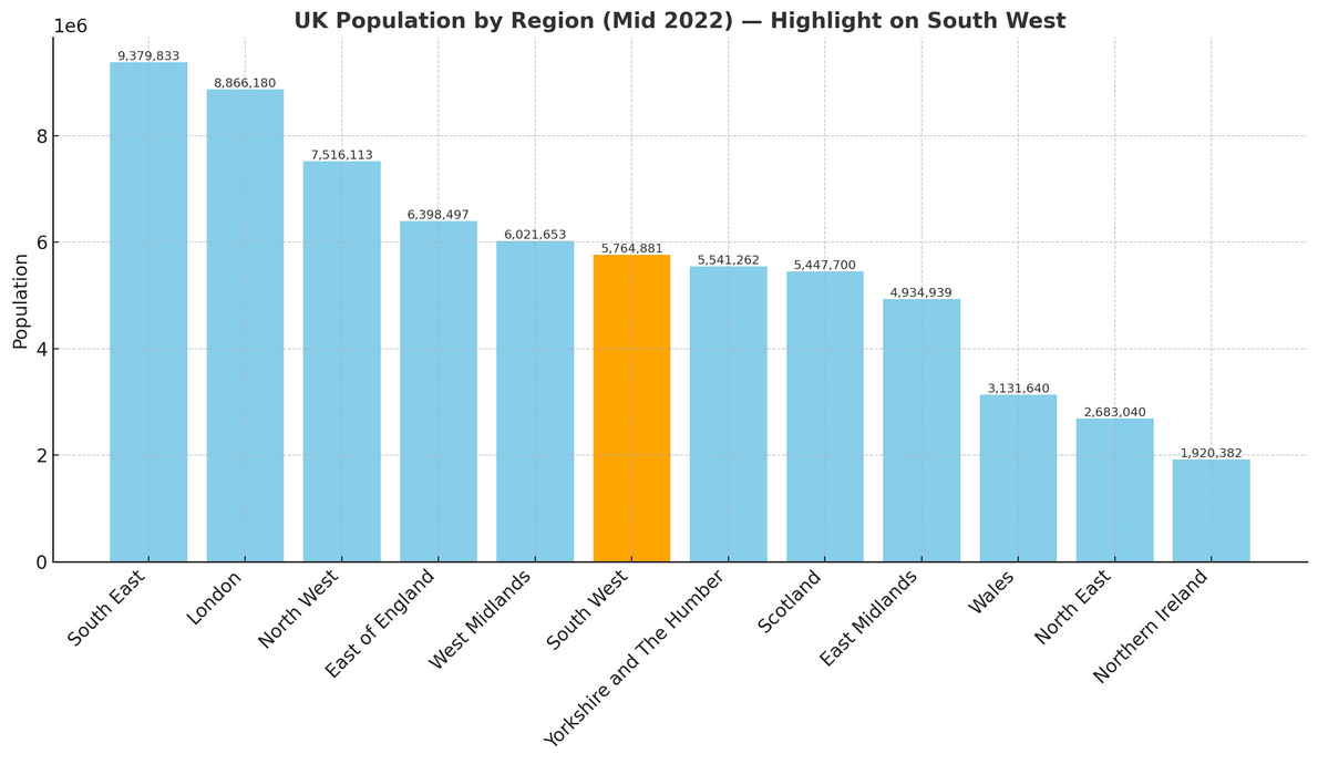
Population of South West England
South West England is home to around 5.76 million people (mid-2022, ONS). Spanning 23,838 square kilometres (9,204 square miles), it has a population density of 242 people per square kilometre—making it the least densely populated region in England.
How it compares to the rest of England
- Population share: The South West accounts for 10.1% of England’s total 57.1 million residents, ranking 6th out of 9 regions by population size.
- Population density: With 242 people per km², the region is much less crowded than the national average of 438 people per km²—196 fewer people per km²—placing it 9th out of 9 regions for density.