South Oxfordshire
§ This page gives an overview of the South Oxfordshire local authority district, bringing together key facts, maps, and data to help you quickly understand the area. This is one of 361 LAD profiles on Baseview.
Overview ⁞ South Oxfordshire stretches from the Chiltern Hills in the east to the Thames Valley, with market towns and riverside villages. Henley-on-Thames is a highlight, famed for its regatta and riverside scenery, while Wallingford retains medieval streets and castle remains. Thame is a bustling market town, and numerous villages with traditional pubs and churches dot the countryside. The landscape includes chalk hills, beech woodlands, and the River Thames winding through meadows and pastures, giving South Oxfordshire a balance of rural beauty and historic charm.
South Oxfordshire Boundary Map
This map shows the official boundary of the South Oxfordshire local authority district, based on the latest geographic data published by the Office for National Statistics (ONS). It provides a clear view of the district’s extent and helps you understand how the area fits within the wider regional and national landscape.
Contains OS data © Crown copyright and database right 2025. Source: Office for National Statistics licensed under the Open Government Licence v3.0.
The administrative boundary of South Oxfordshire can also be viewed on OpenStreetMap: District Boundary of South Oxfordshire.
Key Facts about South Oxfordshire
What region is South Oxfordshire in? South Oxfordshire is in the South East of England, a region within the UK.
What county is South Oxfordshire in? South Oxfordshire is located in the county of Oxfordshire.
Is South Oxfordshire a city? No, South Oxfordshire is not a city. (Note: the UK has 76 officially designated cities.)
Who governs South Oxfordshire? The local authority for this district is: South Oxfordshire District Council - responsible for district-level services. Since Oxfordshire is a two-tier area, county-level services are handled by: Oxfordshire County Council.
▶ Official website of South Oxfordshire District Council 🔗 southoxon.gov.uk
Which police force covers South Oxfordshire? Policing in South Oxfordshire is provided by Thames Valley Police 🔗 thamesvalley.police.uk, which serves 13 local authority districts: Bracknell Forest ⁞ Buckinghamshire ⁞ Cherwell ⁞ Milton Keynes ⁞ Oxford ⁞ Reading ⁞ Slough ⁞ South Oxfordshire ⁞ Vale of White Horse ⁞ West Berkshire ⁞ West Oxfordshire ⁞ Windsor and Maidenhead ⁞ Wokingham.
Constituencies in South Oxfordshire
South Oxfordshire is divided into 2 parliamentary constituencies, listed below in alphabetical order.
A constituency is a specific geographical area that elects one Member of Parliament (MP) to represent them in the House of Commons. The United Kingdom is divided into 650 parliamentary constituencies. We have this list page for easy browsing of all UK parliamentary constituencies: List of Constituencies.
Wards in South Oxfordshire
South Oxfordshire is divided into 21 wards, listed below in alphabetical order.
- Benson & Crowmarsh
- Berinsfield
- Chalgrove
- Chinnor
- Cholsey
- Didcot North East
- Didcot South
- Didcot West
- Forest Hill & Holton
- Garsington & Horspath
- Goring
- Haseley Brook
- Henley-on-Thames
- Kidmore End & Whitchurch
- Sandford & the Wittenhams
- Sonning Common
- Thame
- Wallingford
- Watlington
- Wheatley
- Woodcote & Rotherfield
In the UK, a ward is a subdivision of a local authority area, used mainly for electoral and statistical purposes. Defined by the ONS, wards represent the primary unit for local elections, each returning one or more councillors to the local council. Wards are also used as a key geography for presenting population and census data. We have this list page for easy browsing of all electoral wards: List of all Electoral Wards in the UK.
Parishes in South Oxfordshire
South Oxfordshire is part-parished: 87 civil parishes (listed A-Z below) alongside 1 unparished areas.
- Adwell
- Aston Rowant
- Aston Tirrold
- Aston Upthorpe
- Beckley and Stowood
- Benson
- Berinsfield
- Berrick Salome
- Binfield Heath
- Bix and Assendon
- Brightwell Baldwin
- Brightwell-cum-Sotwell
- Britwell Salome
- Chalgrove
- Checkendon
- Chinnor
- Cholsey
- Clifton Hampden
- Crowell
- Crowmarsh
- Cuddesdon and Denton
- Culham
- Cuxham with Easington
- Didcot
- Dorchester
- Drayton St. Leonard
- East Hagbourne
- Elsfield
- Ewelme
- Eye and Dunsden
- Forest Hill with Shotover
- Garsington
- Goring Heath
- Goring-on-Thames
- Great Haseley
- Great Milton
- Harpsden
- Henley-on-Thames
- Highmoor
- Holton
- Horspath
- Ipsden
- Kidmore End
- Lewknor
- Little Milton
- Little Wittenham
- Long Wittenham
- Mapledurham
- Marsh Baldon
- Moulsford
- Nettlebed
- Newington
- North Moreton
- Nuffield
- Nuneham Courtenay
- Pishill with Stonor
- Pyrton
- Rotherfield Greys
- Rotherfield Peppard
- Sandford-on-Thames
- Shiplake
- Shirburn
- Sonning Common
- South Moreton
- South Stoke
- Stadhampton
- Stanton St. John
- Stoke Row
- Stoke Talmage
- Swyncombe
- Sydenham
- Tetsworth
- Thame
- Tiddington-with-Albury
- Toot Baldon
- Towersey
- Wallingford
- Warborough
- Waterperry with Thomley
- Waterstock
- Watlington
- West Hagbourne
- Wheatfield
- Wheatley
- Whitchurch-on-Thames
- Woodcote
- Woodeaton
A civil parish is the lowest tier of local government in England, used for villages, small towns, and suburbs. They have their own local authority, either a parish council or a parish meeting, which provides local services like managing parks, allotments, and streetlights, and represents the community's views to larger councils.
We have this list page for easy browsing of all parishes: List of Civil Parishes in England and Wales.
Post Towns in South Oxfordshire
Below is a list of post towns in South Oxfordshire, grouped by postcode area:
- OX ▸ Chinnor (OX39) ⁞ Didcot (OX11) ⁞ Thame (OX9) ⁞ Wallingford (OX10) ⁞ Watlington (OX49)
- RG ▸ Henley-on-Thames (RG9)
The UK postal hierarchy begins with broad postcode areas (such as “CB” or “M”), which are divided into smaller postcode districts (such as “CB8” or “M1”) to support accurate mail routing. Each postal address is anchored by a designated post town, the official locality name used in the UK postcode system, which operates independently from Local Authority Districts —the administrative boundaries used for council tax and local government services. Because they serve different purposes, a property’s postal address and its local authority district do not always align exactly.
Built-up Areas in South Oxfordshire
South Oxfordshire covers 76 built-up areas, listed below in alphabetical order.
- Abingdon-on-Thames *
- Aston Rowant
- Aston Tirrold and Aston Upthorpe
- Beckley (South Oxfordshire)
- Benson
- Berinsfield
- Binfield Heath
- Bix
- Brightwell-cum-Sotwell
- Burcot (South Oxfordshire)
- Caversham *
- Chalgrove
- Chalkhouse Green
- Checkendon
- Chinnor
- Cholsey
- Clifton Hampden
- Cray's Pond
- Crowmarsh Gifford
- Culham
- Didcot *
- Dorchester (South Oxfordshire)
- Drayton St Leonard
- East Hagbourne
- Ewelme
- Forest Hill
- Gallowstree Common
- Garsington
- Goring *
- Great Haseley
- Great Milton
- Henley-on-Thames *
- Horspath
- Kidmore End
- Kingston Blount
- Lewknor
- Little Milton
- Long Wittenham
- Lower Shiplake
- Marsh Baldon
- Milton Common
- Moulsford
- Nettlebed
- North Moreton
- Oxford *
- Pangbourne *
- Pyrton
- Reading *
- Rotherfield Peppard
- Sandford-on-Thames
- Shepherd's Green
- Shiplake *
- Sonning *
- Sonning Common
- South Moreton
- South Stoke
- Stadhampton
- Stanton St John
- Stoke Row
- Streatley (West Berkshire) *
- Sutton Courtenay *
- Sydenham
- Tetsworth
- Thame
- Tokers Green
- Towersey
- Wallingford
- Warborough and Shillingford
- Wargrave *
- Watlington (South Oxfordshire)
- West Hagbourne *
- Wheatley
- Whitchurch Hill
- Whitchurch-on-Thames
- Woodcote
- Worminghall *
In the UK, a Built-up Area (BUA) is a continuous urban area of at least 20 hectares (0.2 km²), defined by the ONS as land where buildings are generally no more than 200 metres apart, such as towns, cities, or large villages. (Note: A BUA name marked with an asterisk (*) indicates that the area is situated partly in the district of South Oxfordshire.)
We have this list page for easy browsing of all built-up areas: List of all Built-up Areas in GB.
Railway Stations in South Oxfordshire
South Oxfordshire is served by a number of National Rail stations, providing rail connections to nearby towns, cities, and destinations across Great Britain. The railway stations listed below are located within the South Oxfordshire Local Authority District and are grouped by train operating company for clarity.
- Great Western Railway ▸ Didcot Parkway (OX11 7NR) ⁞ Henley-On-Thames (RG9 1AY) ⁞ Goring and Streatley (RG8 0EP) ⁞ Cholsey (OX10 9QD) ⁞ Shiplake (RG9 3NY) ⁞ Culham (OX14 3BT)
This is a district-level view only. For a complete list of all National Rail stations across Great Britain, see the UK National Rail Stations Directory.
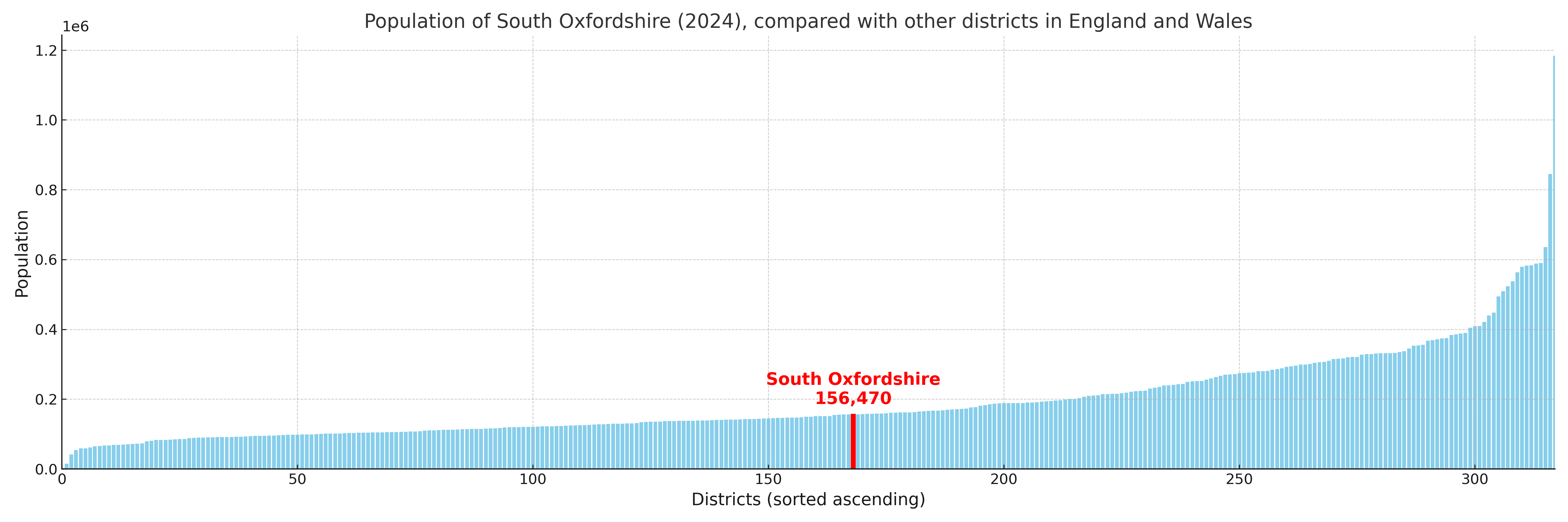
South Oxfordshire compared with other districts in the UK
This section shows how South Oxfordshire compares with other local authority districts in the UK, using a variety of measures and rankings.
South Oxfordshire has 21 electoral wards.

South Oxfordshire has a population of 156,470 (2024 mid-year estimate by ONS)
Population and Migration Trends in South Oxfordshire
This chart shows the population trend for South Oxfordshire from 2015 to 2024. It provides a quick overview of whether the local authority is growing, stable, or declining over time, and helps set context for the migration patterns shown below.
Population change is influenced by natural change (births minus deaths) and migration. The net migration chart below focuses on migration, separating internal migration (moves within the UK) from international migration (moves to and from abroad). Positive values indicate net inflows, while negative values indicate net outflows. The rate labels (per 1,000 residents) help compare migration intensity across years, even when the population size changes.
More local statistics and data for South Oxfordshire can be found on the ONS statistics for South Oxfordshire.
Latest news about South Oxfordshire
Use the search box, or suggested search phrases, below to find recent news, council updates, planning stories, housing developments, transport changes, public services news, local elections, community issues and other local developments related to South Oxfordshire. Results may include coverage from UK national, regional and local news websites, as well as official public-sector and local democracy sources.
- South Oxfordshire council
- South Oxfordshire planning
- South Oxfordshire local elections
- South Oxfordshire housing
- South Oxfordshire transport
- South Oxfordshire regeneration
- South Oxfordshire public services