Yorkshire and the Humber
§ This page provides an overview of UK's Yorkshire and the Humber region, with key facts and data. Last updated on .
Overview ⁞ Yorkshire and the Humber is a diverse region in northern England, renowned for its mix of thriving cities, historic towns, and world-famous landscapes. It is home to the Yorkshire Dales National Park, the North York Moors, and parts of the Peak District, making it a top destination for walking, cycling, and rural tourism. The region’s strong cultural identity is shaped by its industrial heritage in steelmaking, coal mining, textiles, and engineering, as well as its rich history and distinctive Yorkshire dialects.
The region combines metropolitan hubs and rural areas. West Yorkshire and South Yorkshire include major urban centres such as Leeds, Sheffield, Bradford, and Wakefield, governed by metropolitan borough councils. North Yorkshire and the East Riding of Yorkshire, which includes the city of Kingston upon Hull, are largely rural and operate under unitary or county councils. Governance blends traditional county boundaries with modern administrative structures, reflecting the different needs of urban, suburban, and rural communities.
Ceremonial Counties in Yorkshire and the Humber region
Yorkshire and the Humber is made up of four ceremonial counties: West Yorkshire, South Yorkshire, North Yorkshire, and the East Riding of Yorkshire. Each offers a unique character — from the industrial and commercial hubs of Leeds and Sheffield, to the agricultural heartlands of the Vale of York, and the seaside resorts of Scarborough, Bridlington, and Whitby.
Districts in Yorkshire and the Humber
The UK is divided into Local Authority Districts (LADs) as the main building blocks of local government and statistical geography. The following lists all the LADs in this region.
- Unitary Authorities ▸ East Riding of Yorkshire ⁞ Kingston upon Hull, City of ⁞ North East Lincolnshire ⁞ North Lincolnshire ⁞ North Yorkshire ⁞ York
- South Yorkshire ▸ Barnsley ⁞ Doncaster ⁞ Rotherham ⁞ Sheffield
- West Yorkshire ▸ Bradford ⁞ Calderdale ⁞ Kirklees ⁞ Leeds ⁞ Wakefield
Cities in Yorkshire and the Humber
Yorkshire and the Humber is home to several officially designated cities, each holding city status by royal charter rather than population size alone. Below is a complete list of cities in the region, including their local authorities, administrative geography, ceremonial honours, and the year city status was granted.
Ripon parish
- Local authority
- North Yorkshire (Unitary Authority)
- City council (status holder)
- Ripon parish (Civil parish)
- Ceremonial county
- North Yorkshire
- Civic honour
- No additional civic honour
- City status granted
- 1865
City of Wakefield
- Local authority
- Wakefield (Metropolitan borough)
- Ceremonial county
- West Yorkshire
- Civic honour
- No additional civic honour
- City status granted
- 1888
City of Leeds
- Local authority
- Leeds (Metropolitan borough)
- Ceremonial county
- West Yorkshire
- Civic honour
- Lord Mayor
- City status granted
- 1893
City of Sheffield
- Local authority
- Sheffield (Metropolitan borough)
- Ceremonial county
- South Yorkshire
- Civic honour
- Lord Mayor
- City status granted
- 1893
City of Bradford
- Local authority
- Bradford (Metropolitan borough)
- Ceremonial county
- West Yorkshire
- Civic honour
- Lord Mayor
- City status granted
- 1897
City of Kingston upon Hull
- Local authority
- Kingston upon Hull, City of (Unitary authority)
- Ceremonial county
- East Riding of Yorkshire
- Civic honour
- Lord Mayor
- City status granted
- 1897
City of York
- Local authority
- York (Unitary authority)
- Ceremonial county
- North Yorkshire
- Civic honour
- Lord Mayor
- City status granted
- 1996
City of Doncaster
- Local authority
- Doncaster (Metropolitan borough)
- Ceremonial county
- South Yorkshire
- Civic honour
- No additional civic honour
- City status granted
- 2022
Post Towns in Yorkshire and the Humber
Below is a complete list of post towns in Yorkshire and the Humber, grouped by postcode area to make browsing easier.
- DN ▸ Barnetby ⁞ Barrow-upon-Humber ⁞ Barton-upon-Humber ⁞ Brigg ⁞ Cleethorpes ⁞ Doncaster ⁞ Gainsborough ⁞ Goole ⁞ Grimsby ⁞ Immingham ⁞ Retford ⁞ Scunthorpe ⁞ Ulceby
- HD ▸ Brighouse ⁞ Holmfirth ⁞ Huddersfield
- HG ▸ Harrogate ⁞ Knaresborough ⁞ Ripon
- HU ▸ Beverley ⁞ Brough ⁞ Cottingham ⁞ Hessle ⁞ Hornsea ⁞ Hull ⁞ North Ferriby ⁞ Withernsea
- HX ▸ Elland ⁞ Halifax ⁞ Hebden Bridge ⁞ Sowerby Bridge
- LS ▸ Ilkley ⁞ Leeds ⁞ Otley ⁞ Pudsey ⁞ Tadcaster ⁞ Wetherby
- S ▸ Barnsley ⁞ Chesterfield ⁞ Dronfield ⁞ Hope Valley ⁞ Mexborough ⁞ Rotherham ⁞ Sheffield ⁞ Worksop
- WF ▸ Batley ⁞ Castleford ⁞ Dewsbury ⁞ Heckmondwike ⁞ Knottingley ⁞ Liversedge ⁞ Mirfield ⁞ Normanton ⁞ Ossett ⁞ Pontefract ⁞ Wakefield
- YO ▸ Bridlington ⁞ Driffield ⁞ Filey ⁞ Malton ⁞ Pickering ⁞ Scarborough ⁞ Selby ⁞ Thirsk ⁞ Whitby ⁞ York
International Territorial Levels in Yorkshire and the Humber Region
The International Territorial Levels (ITLs) are a hierarchical system of geographic boundaries used for statistical purposes, specifically for regional data analysis and international comparisons. It has three levels: ITL1, ITL2, and ITL3, with ITL1 being the broadest level and ITL3 the most detailed.
Yorkshire and the Humber Region is one of ITL 1 areas in the UK. It is then divided ino the following ITL 2 areas (names in bold letters) and ITL 3 areas.
- East Yorkshire and Northern Lincolnshire — Kingston upon Hull, City of ⁞ East Riding of Yorkshire ⁞ North and North East Lincolnshire
- North Yorkshire — York ⁞ North Yorkshire
- South Yorkshire — Sheffield ⁞ Barnsley ⁞ Rotherham ⁞ Doncaster
- West Yorkshire — Bradford ⁞ Leeds ⁞ Calderdale and Kirklees ⁞ Wakefield
Constituencies in Yorkshire and the Humber
The region contains 54 parliamentary constituencies, covering a wide spectrum from densely populated city seats to expansive rural constituencies. Urban constituencies in Leeds, Sheffield, and Hull contrast with sparsely populated areas in North Yorkshire. This mix of industrial, commercial, agricultural, and tourism-based communities makes Yorkshire and the Humber politically significant in both general and local elections.
- Barnsley North
- Barnsley South
- Beverley and Holderness
- Bradford East
- Bradford South
- Bradford West
- Bridlington and The Wolds
- Brigg and Immingham
- Calder Valley
- Colne Valley
- Dewsbury and Batley
- Doncaster Central
- Doncaster East and the Isle of Axholme
- Doncaster North
- Goole and Pocklington
- Great Grimsby and Cleethorpes
- Halifax
- Harrogate and Knaresborough
- Huddersfield
- Keighley and Ilkley
- Kingston upon Hull East
- Kingston upon Hull North and Cottingham
- Kingston upon Hull West and Haltemprice
- Leeds Central and Headingley
- Leeds East
- Leeds North East
- Leeds North West
- Leeds South
- Leeds South West and Morley
- Leeds West and Pudsey
- Normanton and Hemsworth
- Ossett and Denby Dale
- Penistone and Stocksbridge
- Pontefract, Castleford and Knottingley
- Rawmarsh and Conisbrough
- Richmond and Northallerton
- Rother Valley
- Rotherham
- Scarborough and Whitby
- Scunthorpe
- Selby
- Sheffield Brightside and Hillsborough
- Sheffield Central
- Sheffield Hallam
- Sheffield Heeley
- Sheffield South East
- Shipley
- Skipton and Ripon
- Spen Valley
- Thirsk and Malton
- Wakefield and Rothwell
- Wetherby and Easingwold
- York Central
- York Outer
Population of Yorkshire and the Humber
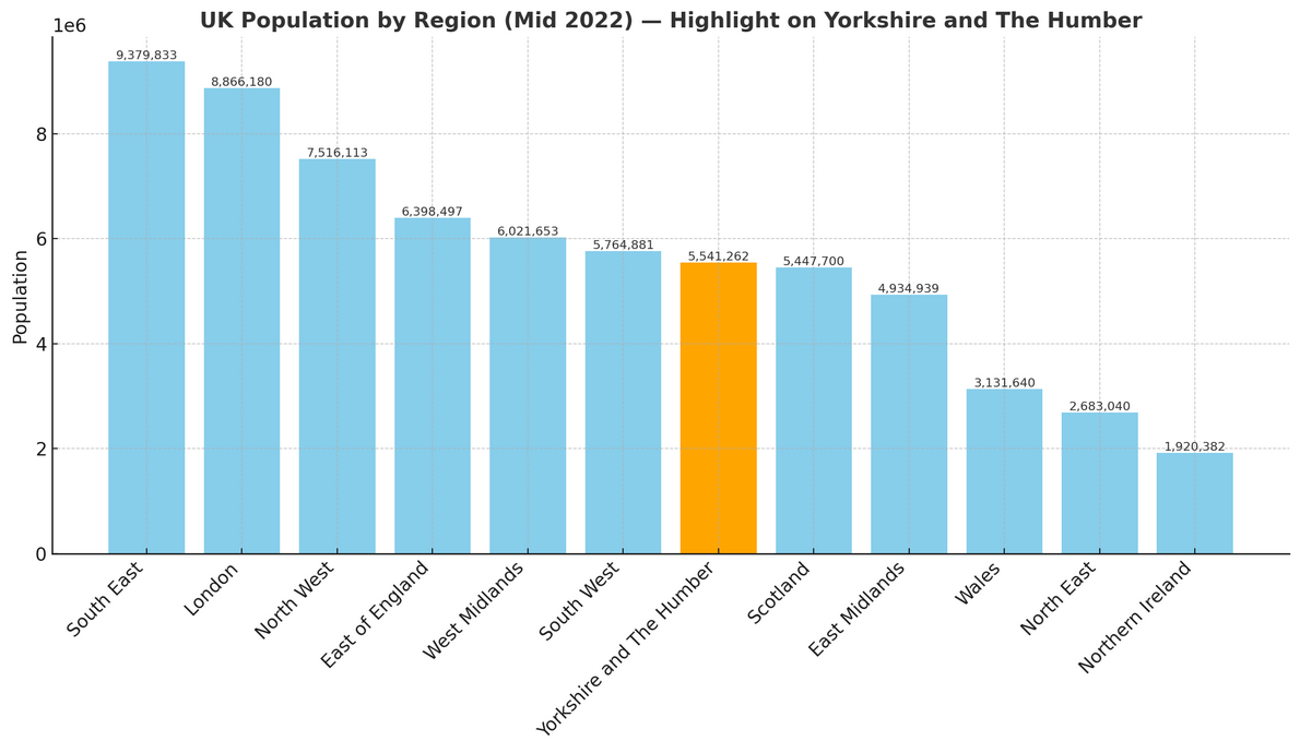
Yorkshire and the Humber is home to around 5.54 million people (mid-2022, ONS). Covering 15,405 square kilometres (5,948 square miles), the region has a population density of 360 people per square kilometre.
How it compares to the rest of England
- Population share: The region accounts for 9.7% of England’s total 57.1 million residents, ranking 7th out of 9 regions by population size.
- Population density: With 360 people per km², Yorkshire and the Humber is less crowded than the national average of 438 people per km²—78 fewer people per km²—placing it 5th out of 9 regions for density.