Canterbury
§ This page gives an overview of the Canterbury local authority district, bringing together key facts, maps, and data to help you quickly understand the area. This is one of 361 LAD profiles on Baseview.
Overview ⁞ Canterbury, in east Kent, is a historic cathedral city, part of a UNESCO World Heritage Site, with medieval streets, the River Stour, and the dominant Canterbury Cathedral. The city centre blends Roman walls, historic churches, and modern amenities, while the wider district includes coastal towns such as Whitstable, famed for its oysters and maritime heritage, and Herne Bay with its seafront and pier. Rolling countryside, woodland, and villages surround the urban centres, giving Canterbury a diverse landscape of coast, heritage, and farmland.
Canterbury Boundary Map
This map shows the official boundary of the Canterbury local authority district, based on the latest geographic data published by the Office for National Statistics (ONS). It provides a clear view of the district’s extent and helps you understand how the area fits within the wider regional and national landscape.
Contains OS data © Crown copyright and database right 2025. Source: Office for National Statistics licensed under the Open Government Licence v3.0.
The administrative boundary of Canterbury can also be viewed on OpenStreetMap: District Boundary of Canterbury.
Key Facts about Canterbury
What region is Canterbury in? Canterbury is in the South East of England, a region within the UK.
What county is Canterbury in? Canterbury is located in the county of Kent.
Is Canterbury a city? Yes, Canterbury is a city. Canterbury holds official city status as one of the 76 designated cities in the UK.
Who governs Canterbury? The local authority for this district is: Canterbury City Council - responsible for district-level services. Since Kent is a two-tier area, county-level services are handled by: Kent County Council.
▶ Official website of Canterbury City Council 🔗 canterbury.gov.uk
Which police force covers Canterbury? Policing in Canterbury is provided by Kent Police 🔗 kent.police.uk, which serves 13 local authority districts: Ashford ⁞ Canterbury ⁞ Dartford ⁞ Dover ⁞ Folkestone and Hythe ⁞ Gravesham ⁞ Maidstone ⁞ Medway ⁞ Sevenoaks ⁞ Swale ⁞ Thanet ⁞ Tonbridge and Malling ⁞ Tunbridge Wells.
Constituencies in Canterbury
Canterbury is divided into 2 parliamentary constituencies, listed below in alphabetical order.
A constituency is a specific geographical area that elects one Member of Parliament (MP) to represent them in the House of Commons. The United Kingdom is divided into 650 parliamentary constituencies. We have this list page for easy browsing of all UK parliamentary constituencies: List of Constituencies.
Wards in Canterbury
Canterbury is divided into 21 wards, listed below in alphabetical order.
- Barton
- Beltinge
- Blean Forest
- Chartham & Stone Street
- Chestfield
- Gorrell
- Greenhill
- Herne & Broomfield
- Heron
- Little Stour & Adisham
- Nailbourne
- Northgate
- Reculver
- Seasalter
- St Stephen's
- Sturry
- Swalecliffe
- Tankerton
- West Bay
- Westgate
- Wincheap
In the UK, a ward is a subdivision of a local authority area, used mainly for electoral and statistical purposes. Defined by the ONS, wards represent the primary unit for local elections, each returning one or more councillors to the local council. Wards are also used as a key geography for presenting population and census data. We have this list page for easy browsing of all electoral wards: List of all Electoral Wards in the UK.
Parishes in Canterbury
Canterbury is part-parished: 27 civil parishes (listed A-Z below) alongside 2 unparished areas.
- Adisham
- Barham
- Bekesbourne-with-Patrixbourne
- Bishopsbourne
- Blean
- Bridge
- Chartham
- Chestfield
- Chislet
- Fordwich
- Hackington
- Harbledown and Rough Common
- Herne and Broomfield
- Hersden
- Hoath
- Ickham and Well
- Kingston
- Littlebourne
- Lower Hardres and Nackington
- Petham
- Sturry
- Thanington
- Upper Hardres
- Waltham
- Westbere
- Wickhambreaux
- Womenswold
A civil parish is the lowest tier of local government in England, used for villages, small towns, and suburbs. They have their own local authority, either a parish council or a parish meeting, which provides local services like managing parks, allotments, and streetlights, and represents the community's views to larger councils.
We have this list page for easy browsing of all parishes: List of Civil Parishes in England and Wales.
Post Towns in Canterbury
Below is a list of post towns in Canterbury, grouped by postcode area:
- CT ▸ Canterbury (CT1 / CT2 / CT3 / CT4) ⁞ Herne Bay (CT6) ⁞ Whitstable (CT5)
The UK postal hierarchy begins with broad postcode areas (such as “CB” or “M”), which are divided into smaller postcode districts (such as “CB8” or “M1”) to support accurate mail routing. Each postal address is anchored by a designated post town, the official locality name used in the UK postcode system, which operates independently from Local Authority Districts —the administrative boundaries used for council tax and local government services. Because they serve different purposes, a property’s postal address and its local authority district do not always align exactly.
Built-up Areas in Canterbury
Canterbury covers 27 built-up areas, listed below in alphabetical order.
- Adisham
- Aylesham *
- Barham
- Bishopsbourne
- Blean
- Bossingham *
- Bridge
- Broad Oak (Canterbury)
- Canterbury
- Chartham
- Chilham *
- Herne
- Herne Bay
- Hersden
- Kingston (Canterbury)
- Littlebourne
- Lower Hardres and Street End
- Preston (Dover) *
- Rough Common
- Sturry
- Tyler Hill
- Upper Harbledown
- Upstreet
- Waterham *
- Whitstable
- Wickhambreaux
- Yorkletts *
In the UK, a Built-up Area (BUA) is a continuous urban area of at least 20 hectares (0.2 km²), defined by the ONS as land where buildings are generally no more than 200 metres apart, such as towns, cities, or large villages. (Note: A BUA name marked with an asterisk (*) indicates that the area is situated partly in the district of Canterbury.)
We have this list page for easy browsing of all built-up areas: List of all Built-up Areas in GB.
Railway Stations in Canterbury
Canterbury is served by a number of National Rail stations, providing rail connections to nearby towns, cities, and destinations across Great Britain. The railway stations listed below are located within the Canterbury Local Authority District and are grouped by train operating company for clarity.
- Southeastern ▸ Canterbury West (CT2 8AN) ⁞ Canterbury East (CT1 2RB) ⁞ Whitstable (CT5 1RB) ⁞ Herne Bay (CT6 8PJ) ⁞ Sturry (CT2 0ED) ⁞ Chestfield and Swalecliffe (CT5 3JB) ⁞ Chartham (CT4 7HT) ⁞ Bekesbourne (CT4 5EP) ⁞ Adisham (CT3 3JE)
This is a district-level view only. For a complete list of all National Rail stations across Great Britain, see the UK National Rail Stations Directory.
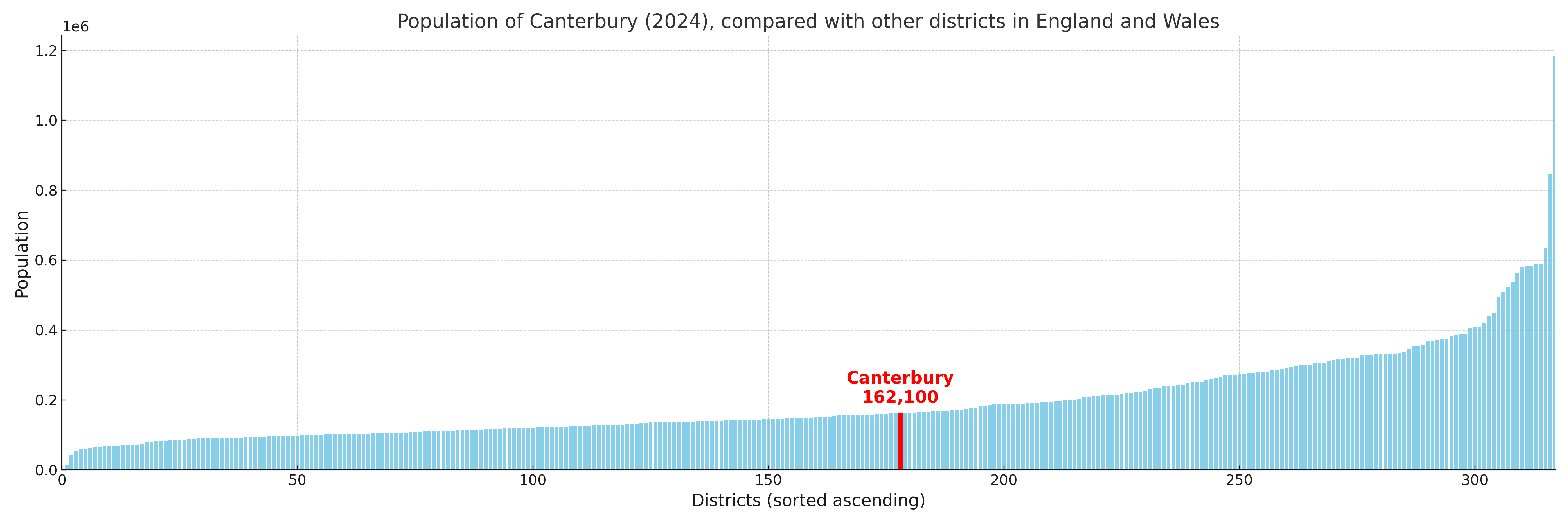
Canterbury compared with other districts in the UK
This section shows how Canterbury compares with other local authority districts in the UK, using a variety of measures and rankings.
Canterbury has 21 electoral wards.

Canterbury has a population of 162,100 (2024 mid-year estimate by ONS)
Population and Migration Trends in Canterbury
This chart shows the population trend for Canterbury from 2015 to 2024. It provides a quick overview of whether the local authority is growing, stable, or declining over time, and helps set context for the migration patterns shown below.
Population change is influenced by natural change (births minus deaths) and migration. The net migration chart below focuses on migration, separating internal migration (moves within the UK) from international migration (moves to and from abroad). Positive values indicate net inflows, while negative values indicate net outflows. The rate labels (per 1,000 residents) help compare migration intensity across years, even when the population size changes.
More local statistics and data for Canterbury can be found on the ONS statistics for Canterbury.
Latest news about Canterbury
Use the search box, or suggested search phrases, below to find recent news, council updates, planning stories, housing developments, transport changes, public services news, local elections, community issues and other local developments related to Canterbury. Results may include coverage from UK national, regional and local news websites, as well as official public-sector and local democracy sources.
- Canterbury council
- Canterbury planning
- Canterbury local elections
- Canterbury housing
- Canterbury transport
- Canterbury regeneration
- Canterbury public services