Maidstone
§ This page gives an overview of the Maidstone local authority district, bringing together key facts, maps, and data to help you quickly understand the area. This is one of 361 LAD profiles on Baseview.
Overview ⁞ Maidstone, in the heart of Kent, is a busy county town on the River Medway, surrounded by orchards, farmland, and villages. The town centre features Maidstone Museum, Archbishop’s Palace, and riverside parks, while the Medway Valley adds scenic landscapes and trails. Leeds Castle, often described as one of the loveliest in the world, lies nearby with its lakes and grounds. The wider district includes rolling hills, hop fields, and fruit farms, forming part of the Kent Downs Area of Outstanding Natural Beauty. Its geography combines urban vibrancy with countryside and historic estates.
Maidstone Boundary Map
This map shows the official boundary of the Maidstone local authority district, based on the latest geographic data published by the Office for National Statistics (ONS). It provides a clear view of the district’s extent and helps you understand how the area fits within the wider regional and national landscape.
Contains OS data © Crown copyright and database right 2025. Source: Office for National Statistics licensed under the Open Government Licence v3.0.
The administrative boundary of Maidstone can also be viewed on OpenStreetMap: District Boundary of Maidstone.
Key Facts about Maidstone
What region is Maidstone in? Maidstone is in the South East of England, a region within the UK.
What county is Maidstone in? Maidstone is located in the county of Kent.
Is Maidstone a city? No, Maidstone is not a city. (Note: the UK has 76 officially designated cities.)
Who governs Maidstone? The local authority for this district is: Maidstone Borough Council - responsible for district-level services. Since Kent is a two-tier area, county-level services are handled by: Kent County Council.
▶ Official website of Maidstone Borough Council 🔗 maidstone.gov.uk
Which police force covers Maidstone? Policing in Maidstone is provided by Kent Police 🔗 kent.police.uk, which serves 13 local authority districts: Ashford ⁞ Canterbury ⁞ Dartford ⁞ Dover ⁞ Folkestone and Hythe ⁞ Gravesham ⁞ Maidstone ⁞ Medway ⁞ Sevenoaks ⁞ Swale ⁞ Thanet ⁞ Tonbridge and Malling ⁞ Tunbridge Wells.
Constituencies in Maidstone
Maidstone is divided into 3 parliamentary constituencies, listed below in alphabetical order.
A constituency is a specific geographical area that elects one Member of Parliament (MP) to represent them in the House of Commons. The United Kingdom is divided into 650 parliamentary constituencies. We have this list page for easy browsing of all UK parliamentary constituencies: List of Constituencies.
Wards in Maidstone
Maidstone is divided into 22 wards, listed below in alphabetical order.
- Allington & Bridge
- Barming Heath & Teston
- Bearsted & Downswood
- Boughton Monchelsea & Chart Sutton
- Boxley Downs
- Coxheath & Farleigh
- Fant & Oakwood
- Grove Green & Vinters Park
- Harrietsham, Lenham & North Downs
- Headcorn & Sutton Valence
- High Street
- Leeds & Langley
- Loose & Linton
- Marden & Yalding
- Palace Wood
- Park Wood & Mangravet
- Penenden Heath
- Ringlestone
- Senacre
- Shepway
- Staplehurst
- Tovil
In the UK, a ward is a subdivision of a local authority area, used mainly for electoral and statistical purposes. Defined by the ONS, wards represent the primary unit for local elections, each returning one or more councillors to the local council. Wards are also used as a key geography for presenting population and census data. We have this list page for easy browsing of all electoral wards: List of all Electoral Wards in the UK.
Parishes in Maidstone
Maidstone is part-parished: 41 civil parishes (listed A-Z below) alongside 4 unparished areas.
- Barming
- Bearsted
- Bicknor
- Boughton Malherbe
- Boughton Monchelsea
- Boxley
- Bredhurst
- Broomfield and Kingswood
- Chart Sutton
- Collier Street
- Coxheath
- Detling
- Downswood
- East Farleigh
- East Sutton
- Frinsted
- Harrietsham
- Headcorn
- Hollingbourne
- Hucking
- Hunton
- Langley
- Leeds
- Lenham
- Linton
- Loose
- Marden
- Nettlestead
- Otham
- Otterden
- Staplehurst
- Stockbury
- Sutton Valence
- Teston
- Thurnham
- Tovil
- Ulcombe
- West Farleigh
- Wichling
- Wormshill
- Yalding
A civil parish is the lowest tier of local government in England, used for villages, small towns, and suburbs. They have their own local authority, either a parish council or a parish meeting, which provides local services like managing parks, allotments, and streetlights, and represents the community's views to larger councils.
We have this list page for easy browsing of all parishes: List of Civil Parishes in England and Wales.
Post Towns in Maidstone
Below is a list of post towns in Maidstone, grouped by postcode area:
ME ▸ Maidstone (ME14 / ME15 / ME16 / ME17 / ME18 / ME99)
The UK postal hierarchy begins with broad postcode areas (such as “CB” or “M”), which are divided into smaller postcode districts (such as “CB8” or “M1”) to support accurate mail routing. Each postal address is anchored by a designated post town, the official locality name used in the UK postcode system, which operates independently from Local Authority Districts —the administrative boundaries used for council tax and local government services. Because they serve different purposes, a property’s postal address and its local authority district do not always align exactly.
Built-up Areas in Maidstone
Maidstone covers 28 built-up areas, listed below in alphabetical order.
- Bearsted
- Benover
- Bredhurst
- Chainhurst
- Chart Sutton
- Chartway Street
- Chatham *
- Coxheath
- Curtisden Green *
- Detling
- East Farleigh
- Forstal *
- Gillingham (Medway) *
- Headcorn
- Kings Hill *
- Kingswood (Maidstone)
- Langley (Maidstone)
- Langley Heath
- Lenham and Harrietsham
- Maidstone *
- Marden (Maidstone)
- Paddock Wood *
- Staplehurst
- Sutton Valence
- Teston
- Ulcombe
- Wateringbury *
- Yalding
In the UK, a Built-up Area (BUA) is a continuous urban area of at least 20 hectares (0.2 km²), defined by the ONS as land where buildings are generally no more than 200 metres apart, such as towns, cities, or large villages. (Note: A BUA name marked with an asterisk (*) indicates that the area is situated partly in the district of Maidstone.)
We have this list page for easy browsing of all built-up areas: List of all Built-up Areas in GB.
Railway Stations in Maidstone
Maidstone is served by a number of National Rail stations, providing rail connections to nearby towns, cities, and destinations across Great Britain. The railway stations listed below are located within the Maidstone Local Authority District and are grouped by train operating company for clarity.
- Southeastern ▸ Maidstone East (ME14 1QN) ⁞ Staplehurst (TN12 0QR) ⁞ Headcorn (TN27 9SD) ⁞ Maidstone West (ME16 8RJ) ⁞ Marden (Kent) (TN12 9HS) ⁞ Bearsted (ME14 4PH) ⁞ Maidstone Barracks (ME16 0SQ) ⁞ Lenham (ME17 2HR) ⁞ Harrietsham (ME17 1JA) ⁞ Hollingbourne (ME17 1TX) ⁞ Yalding (ME18 6HN) ⁞ East Farleigh (ME15 0JH)
This is a district-level view only. For a complete list of all National Rail stations across Great Britain, see the UK National Rail Stations Directory.
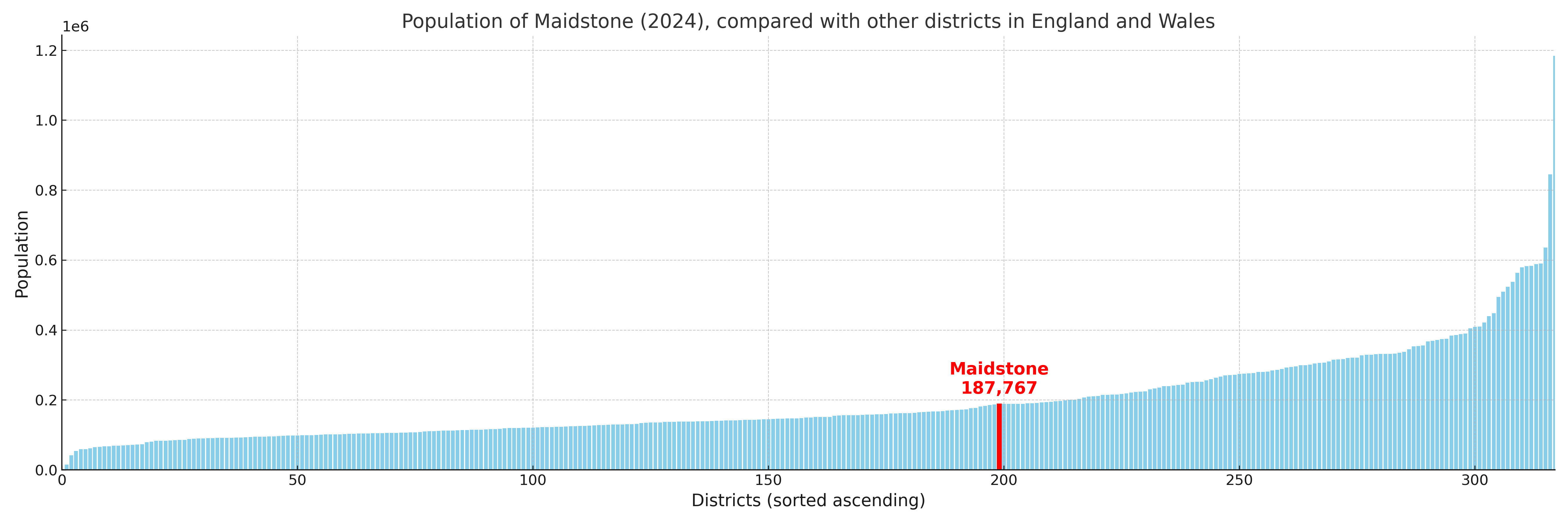
Maidstone compared with other districts in the UK
This section shows how Maidstone compares with other local authority districts in the UK, using a variety of measures and rankings.
Maidstone has 22 electoral wards.

Maidstone has a population of 187,767 (2024 mid-year estimate by ONS)
Population and Migration Trends in Maidstone
This chart shows the population trend for Maidstone from 2015 to 2024. It provides a quick overview of whether the local authority is growing, stable, or declining over time, and helps set context for the migration patterns shown below.
Population change is influenced by natural change (births minus deaths) and migration. The net migration chart below focuses on migration, separating internal migration (moves within the UK) from international migration (moves to and from abroad). Positive values indicate net inflows, while negative values indicate net outflows. The rate labels (per 1,000 residents) help compare migration intensity across years, even when the population size changes.
More local statistics and data for Maidstone can be found on the ONS statistics for Maidstone.
Latest news about Maidstone
Use the search box, or suggested search phrases, below to find recent news, council updates, planning stories, housing developments, transport changes, public services news, local elections, community issues and other local developments related to Maidstone. Results may include coverage from UK national, regional and local news websites, as well as official public-sector and local democracy sources.
- Maidstone council
- Maidstone planning
- Maidstone local elections
- Maidstone housing
- Maidstone transport
- Maidstone regeneration
- Maidstone public services