King's Lynn and West Norfolk
§ This page gives an overview of the King's Lynn and West Norfolk local authority district, bringing together key facts, maps, and data to help you quickly understand the area. This is one of 361 LAD profiles on Baseview.
Overview ⁞ King’s Lynn and West Norfolk covers a vast area stretching from the Wash coastline to inland countryside. King’s Lynn, the main town, has a historic port heritage, medieval guildhalls, and cobbled streets. The coastline includes saltmarshes, beaches, and nature reserves, such as those at Hunstanton and Holme-next-the-Sea. Inland, market towns like Downham Market and Swaffham add charm, while the Fens in the south and rolling countryside in the north create contrasting landscapes. Its geography encompasses maritime heritage, agricultural land, and wide open spaces.
King's Lynn and West Norfolk Boundary Map
This map shows the official boundary of the King's Lynn and West Norfolk local authority district, based on the latest geographic data published by the Office for National Statistics (ONS). It provides a clear view of the district’s extent and helps you understand how the area fits within the wider regional and national landscape.
Contains OS data © Crown copyright and database right 2025. Source: Office for National Statistics licensed under the Open Government Licence v3.0.
The administrative boundary of King's Lynn and West Norfolk can also be viewed on OpenStreetMap: District Boundary of King's Lynn and West Norfolk.
Key Facts about King's Lynn and West Norfolk
What region are King's Lynn and West Norfolk in? King's Lynn and West Norfolk are in the East of England of England, a region within the UK.
What county is King's Lynn and West Norfolk in? King's Lynn and West Norfolk is located in the county of Norfolk.
Is King's Lynn and West Norfolk a city? No, King's Lynn and West Norfolk is not a city. (Note: the UK has 76 officially designated cities.)
Who governs King's Lynn and West Norfolk? The local authority for this district is: Kings Lynn & West Norfolk Borough Council - responsible for district-level services. Since Norfolk is a two-tier area, county-level services are handled by: Norfolk County Council.
▶ Official website of Kings Lynn & West Norfolk Borough Council 🔗 west-norfolk.gov.uk
Which police force covers King's Lynn and West Norfolk? Policing in King's Lynn and West Norfolk is provided by Norfolk Constabulary 🔗 norfolk.police.uk, which serves 7 local authority districts: Breckland ⁞ Broadland ⁞ Great Yarmouth ⁞ King's Lynn and West Norfolk ⁞ North Norfolk ⁞ Norwich ⁞ South Norfolk.
Constituencies in King's Lynn and West Norfolk
King's Lynn and West Norfolk is divided into 2 parliamentary constituencies, listed below in alphabetical order.
A constituency is a specific geographical area that elects one Member of Parliament (MP) to represent them in the House of Commons. The United Kingdom is divided into 650 parliamentary constituencies. We have this list page for easy browsing of all UK parliamentary constituencies: List of Constituencies.
Wards in King's Lynn and West Norfolk
King's Lynn and West Norfolk is divided into 35 wards, listed below in alphabetical order.
- Airfield
- Bircham with Rudhams
- Brancaster
- Burnham Market & Docking
- Clenchwarton
- Denver
- Dersingham
- Downham Old Town
- East Downham
- Emneth & Outwell
- Fairstead
- Feltwell
- Gayton & Grimston
- Gaywood Chase
- Gaywood Clock
- Gaywood North Bank
- Heacham
- Hunstanton
- Massingham with Castle Acre
- Methwold
- North Downham
- North Lynn
- Snettisham
- South & West Lynn
- South Downham
- Springwood
- St. Margaret's with St. Nicholas
- Terrington
- The Woottons
- Tilney, Mershe Lande & Wiggenhall
- Upwell & Delph
- Walsoken, West Walton & Walpole
- Watlington
- West Winch
- Wissey
In the UK, a ward is a subdivision of a local authority area, used mainly for electoral and statistical purposes. Defined by the ONS, wards represent the primary unit for local elections, each returning one or more councillors to the local council. Wards are also used as a key geography for presenting population and census data. We have this list page for easy browsing of all electoral wards: List of all Electoral Wards in the UK.
Parishes in King's Lynn and West Norfolk
King's Lynn and West Norfolk is part-parished: 101 civil parishes (listed A-Z below) alongside 1 unparished areas.
- Anmer
- Bagthorpe with Barmer
- Barton Bendish
- Barwick
- Bawsey
- Bircham
- Boughton
- Brancaster
- Burnham Market
- Burnham Norton
- Burnham Overy
- Burnham Thorpe
- Castle Acre
- Castle Rising
- Choseley
- Clenchwarton
- Congham
- Crimplesham
- Denver
- Dersingham
- Docking
- Downham Market
- Downham West
- East Rudham
- East Walton
- East Winch
- Emneth
- Feltwell
- Fincham
- Flitcham with Appleton
- Fordham
- Fring
- Gayton
- Great Massingham
- Grimston
- Harpley
- Heacham
- Hilgay
- Hillington
- Hockwold cum Wilton
- Holme next the Sea
- Houghton
- Hunstanton
- Ingoldisthorpe
- Leziate
- Little Massingham
- Marham
- Marshland St. James
- Methwold
- Middleton
- Nordelph
- North Creake
- North Runcton
- North Wootton
- Northwold
- Old Hunstanton
- Outwell
- Pentney
- Ringstead
- Roydon
- Runcton Holme
- Ryston
- Sandringham
- Sedgeford
- Shernborne
- Shouldham
- Shouldham Thorpe
- Snettisham
- South Creake
- South Wootton
- Southery
- Stanhoe
- Stoke Ferry
- Stow Bardolph
- Stradsett
- Syderstone
- Terrington St. Clement
- Terrington St. John
- Thornham
- Tilney All Saints
- Tilney St. Lawrence
- Titchwell
- Tottenhill
- Upwell
- Walpole
- Walpole Cross Keys
- Walpole Highway
- Walsoken
- Watlington
- Welney
- Wereham
- West Acre
- West Dereham
- West Rudham
- West Walton
- West Winch
- Wiggenhall St. Germans
- Wiggenhall St. Mary Magdalen
- Wimbotsham
- Wormegay
- Wretton
A civil parish is the lowest tier of local government in England, used for villages, small towns, and suburbs. They have their own local authority, either a parish council or a parish meeting, which provides local services like managing parks, allotments, and streetlights, and represents the community's views to larger councils.
We have this list page for easy browsing of all parishes: List of Civil Parishes in England and Wales.
Post Towns in King's Lynn and West Norfolk
Below is a list of post towns in King's Lynn and West Norfolk, grouped by postcode area:
- PE ▸ Downham Market (PE38) ⁞ Hunstanton (PE36) ⁞ King's Lynn (PE30 / PE31 / PE32 / PE33 / PE34) ⁞ Sandringham (PE35)
The UK postal hierarchy begins with broad postcode areas (such as “CB” or “M”), which are divided into smaller postcode districts (such as “CB8” or “M1”) to support accurate mail routing. Each postal address is anchored by a designated post town, the official locality name used in the UK postcode system, which operates independently from Local Authority Districts —the administrative boundaries used for council tax and local government services. Because they serve different purposes, a property’s postal address and its local authority district do not always align exactly.
Built-up Areas in King's Lynn and West Norfolk
King's Lynn and West Norfolk covers 79 built-up areas, listed below in alphabetical order.
- Ashwicken
- Barroway Drove
- Bircham Newton
- Blackborough End
- Boughton (King's Lynn and West Norfolk)
- Brancaster
- Brancaster Staithe
- Brookville
- Burnham Market
- Burnham Overy Staithe
- Castle Acre
- Christchurch (Fenland) *
- Clenchwarton
- Denver
- Dersingham
- Docking
- Downham Market
- East Rudham
- East Winch
- Elm and Emneth *
- Feltwell
- Fincham
- Gayton (King's Lynn and West Norfolk)
- Great Bircham
- Great Massingham
- Grimston
- Heacham
- Hilgay
- Hillington
- Hockwold cum Wilton
- Holme next the Sea
- Hunstanton
- Ingoldisthorpe
- King's Lynn
- Marham *
- Marshland St James
- Methwold
- Middleton (King's Lynn and West Norfolk)
- Narborough *
- North Creake
- North Runcton
- Northwold
- Old Hunstanton
- Paradise
- Pott Row
- Ringstead (King's Lynn and West Norfolk)
- Roydon (King's Lynn and West Norfolk)
- Runcton Holme
- Sedgeford
- Setchey
- Shepherd's Port
- Shouldham
- Snettisham
- Southery
- Stanhoe
- Stoke Ferry
- Stow Bridge
- Terrington St Clement
- Thornham
- Tilney St Lawrence
- Upwell and Outwell *
- Walpole Cross Keys
- Walpole Highway
- Walpole Marsh
- Walpole St Peter and Walpole St Andrew
- Walton Highway
- Watlington (King's Lynn and West Norfolk)
- Welney
- Wereham
- West Dereham
- West Walton
- West Winch
- Whittington (King's Lynn and West Norfolk)
- Wicken Green Village *
- Wiggenhall St Germans
- Wiggenhall St Mary Magdalen
- Wimbotsham
- Wisbech *
- Wretton
In the UK, a Built-up Area (BUA) is a continuous urban area of at least 20 hectares (0.2 km²), defined by the ONS as land where buildings are generally no more than 200 metres apart, such as towns, cities, or large villages. (Note: A BUA name marked with an asterisk (*) indicates that the area is situated partly in the district of King's Lynn and West Norfolk.)
We have this list page for easy browsing of all built-up areas: List of all Built-up Areas in GB.
Railway Stations in King's Lynn and West Norfolk
King's Lynn and West Norfolk is served by a number of National Rail stations, providing rail connections to nearby towns, cities, and destinations across Great Britain. The railway stations listed below are located within the King's Lynn and West Norfolk Local Authority District and are grouped by train operating company for clarity.
- Govia Thameslink Railway (Great Northern) ▸ Kings Lynn (PE30 1NX) ⁞ Downham Market (PE38 9EN) ⁞ Watlington (PE33 0JF)
This is a district-level view only. For a complete list of all National Rail stations across Great Britain, see the UK National Rail Stations Directory.
King's Lynn and West Norfolk compared with other districts in the UK
This section shows how King's Lynn and West Norfolk compares with other local authority districts in the UK, using a variety of measures and rankings.
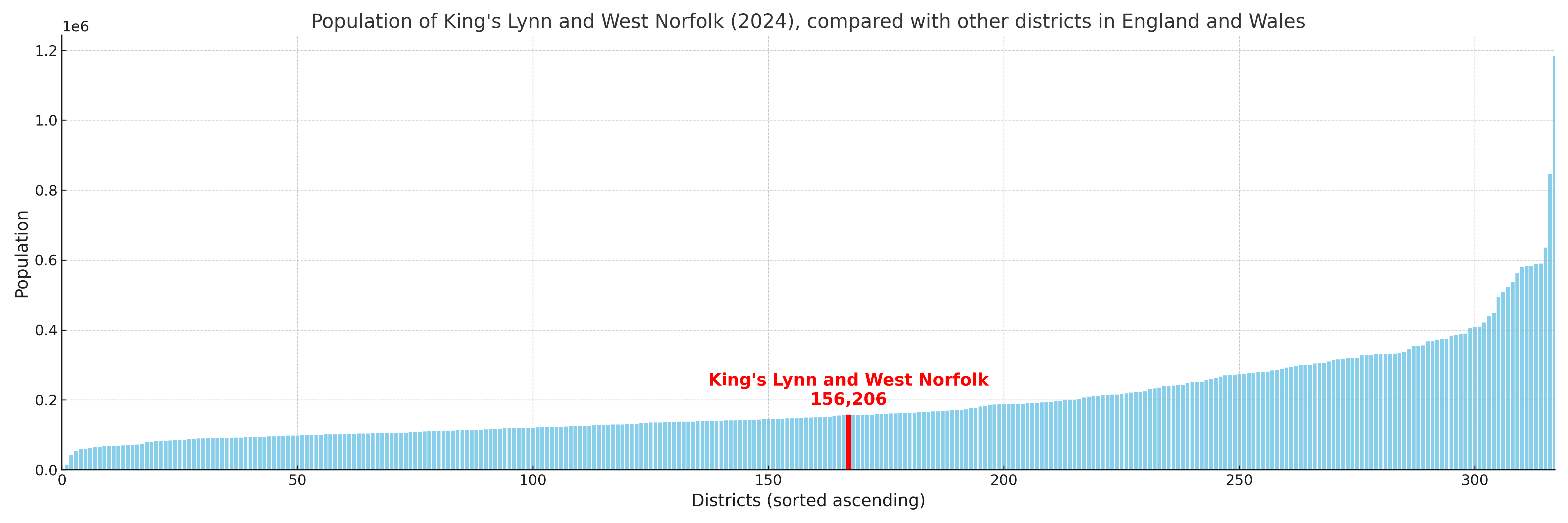
King's Lynn and West Norfolk has 35 electoral wards.

King's Lynn and West Norfolk has a population of 156,206 (2024 mid-year estimate by ONS)
Population and Migration Trends in King's Lynn and West Norfolk
This chart shows the population trend for King's Lynn and West Norfolk from 2015 to 2024. It provides a quick overview of whether the local authority is growing, stable, or declining over time, and helps set context for the migration patterns shown below.
Population change is influenced by natural change (births minus deaths) and migration. The net migration chart below focuses on migration, separating internal migration (moves within the UK) from international migration (moves to and from abroad). Positive values indicate net inflows, while negative values indicate net outflows. The rate labels (per 1,000 residents) help compare migration intensity across years, even when the population size changes.
More local statistics and data for King's Lynn and West Norfolk can be found on the ONS statistics for King's Lynn and West Norfolk.
Latest news about King's Lynn and West Norfolk
Use the search box, or suggested search phrases, below to find recent news, council updates, planning stories, housing developments, transport changes, public services news, local elections, community issues and other local developments related to King's Lynn and West Norfolk. Results may include coverage from UK national, regional and local news websites, as well as official public-sector and local democracy sources.
- King's Lynn and West Norfolk council
- King's Lynn and West Norfolk planning
- King's Lynn and West Norfolk local elections
- King's Lynn and West Norfolk housing
- King's Lynn and West Norfolk transport
- King's Lynn and West Norfolk regeneration
- King's Lynn and West Norfolk public services