Colchester
§ This page gives an overview of the Colchester local authority district, bringing together key facts, maps, and data to help you quickly understand the area. This is one of 361 LAD profiles on Baseview.
Overview ⁞ Colchester, Britain’s oldest recorded town, is steeped in Roman history, with landmarks such as Colchester Castle, the Roman Walls, and the remains of a Roman theatre. Today it is a thriving town with a busy centre, cultural attractions like Colchester Zoo, and green spaces such as Castle Park. The town blends heritage with modern living, and surrounding villages and countryside in north Essex add to its appeal. The coast is nearby, with Mersea Island offering beaches and seafood, while Dedham Vale and Constable Country lie to the north. Colchester’s combination of history, culture, and landscapes makes it a significant destination.
Colchester Boundary Map
This map shows the official boundary of the Colchester local authority district, based on the latest geographic data published by the Office for National Statistics (ONS). It provides a clear view of the district’s extent and helps you understand how the area fits within the wider regional and national landscape.
Contains OS data © Crown copyright and database right 2025. Source: Office for National Statistics licensed under the Open Government Licence v3.0.
The administrative boundary of Colchester can also be viewed on OpenStreetMap: District Boundary of Colchester.
Key Facts about Colchester
What region is Colchester in? Colchester is in the East of England of England, a region within the UK.
What county is Colchester in? Colchester is located in the county of Essex.
Is Colchester a city? Yes, Colchester is a city. Colchester holds official city status as one of the 76 designated cities in the UK.
Who governs Colchester? The local authority for this district is: Colchester City Council - responsible for district-level services. Since Essex is a two-tier area, county-level services are handled by: Essex County Council.
▶ Official website of Colchester City Council 🔗 colchester.gov.uk
Which police force covers Colchester? Policing in Colchester is provided by Essex Police 🔗 essex.police.uk, which serves 14 local authority districts: Basildon ⁞ Braintree ⁞ Brentwood ⁞ Castle Point ⁞ Chelmsford ⁞ Colchester ⁞ Epping Forest ⁞ Harlow ⁞ Maldon ⁞ Rochford ⁞ Southend-on-Sea ⁞ Tendring ⁞ Thurrock ⁞ Uttlesford.
Constituencies in Colchester
Colchester is divided into 3 parliamentary constituencies, listed below in alphabetical order.
A constituency is a specific geographical area that elects one Member of Parliament (MP) to represent them in the House of Commons. The United Kingdom is divided into 650 parliamentary constituencies. We have this list page for easy browsing of all UK parliamentary constituencies: List of Constituencies.
Wards in Colchester
Colchester is divided into 17 wards, listed below in alphabetical order.
- Berechurch
- Castle
- Greenstead
- Highwoods
- Lexden and Braiswick
- Marks Tey and Layer
- Mersea and Pyefleet
- Mile End
- New Town and Christ Church
- Old Heath and The Hythe
- Prettygate
- Rural North
- Shrub End
- St Anne's and St John's
- Stanway
- Tiptree
- Wivenhoe
In the UK, a ward is a subdivision of a local authority area, used mainly for electoral and statistical purposes. Defined by the ONS, wards represent the primary unit for local elections, each returning one or more councillors to the local council. Wards are also used as a key geography for presenting population and census data. We have this list page for easy browsing of all electoral wards: List of all Electoral Wards in the UK.
Parishes in Colchester
Colchester is part-parished: 35 civil parishes (listed A-Z below) alongside 2 unparished areas.
- Abberton
- Aldham
- Birch
- Boxted
- Chappel
- Copford
- Dedham
- East Donyland
- East Mersea
- Eight Ash Green
- Fingringhoe
- Fordham
- Great and Little Wigborough
- Great Horkesley
- Great Tey
- Langenhoe
- Langham
- Layer Breton
- Layer Marney
- Layer-de-la-Haye
- Little Horkesley
- Marks Tey
- Messing-cum-Inworth
- Mount Bures
- Myland
- Peldon
- Salcott
- Stanway
- Tiptree
- Virley
- Wakes Colne
- West Bergholt
- West Mersea
- Wivenhoe
- Wormingford
A civil parish is the lowest tier of local government in England, used for villages, small towns, and suburbs. They have their own local authority, either a parish council or a parish meeting, which provides local services like managing parks, allotments, and streetlights, and represents the community's views to larger councils.
We have this list page for easy browsing of all parishes: List of Civil Parishes in England and Wales.
Post Towns in Colchester
Below is a list of post towns in Colchester, grouped by postcode area:
CO ▸ Colchester (CO1 / CO2 / CO3 / CO4 / CO5 / CO6 / CO7)
The UK postal hierarchy begins with broad postcode areas (such as “CB” or “M”), which are divided into smaller postcode districts (such as “CB8” or “M1”) to support accurate mail routing. Each postal address is anchored by a designated post town, the official locality name used in the UK postcode system, which operates independently from Local Authority Districts —the administrative boundaries used for council tax and local government services. Because they serve different purposes, a property’s postal address and its local authority district do not always align exactly.
Built-up Areas in Colchester
Colchester covers 34 built-up areas, listed below in alphabetical order.
- Berechurch
- Boxted
- Boxted Cross
- Chappel
- Colchester *
- Copford
- Dedham *
- Dedham Heath
- East Mersea
- Eight Ash Green
- Fingringhoe
- Fordham (Colchester)
- Fordstreet
- Foxash Estate *
- Great Horkesley
- Great Tey
- Heckfordbridge
- High Park Corner
- Lamb Corner *
- Langenhoe and Abberton
- Langham (Colchester)
- Layer Breton
- Layer-de-la-Haye
- Marks Tey
- Nayland *
- Peldon
- Rowhedge
- Stratford St Mary *
- Tiptree *
- Tolleshunt Knights *
- Tye Green (Colchester)
- West Bergholt
- West Mersea
- Wivenhoe *
In the UK, a Built-up Area (BUA) is a continuous urban area of at least 20 hectares (0.2 km²), defined by the ONS as land where buildings are generally no more than 200 metres apart, such as towns, cities, or large villages. (Note: A BUA name marked with an asterisk (*) indicates that the area is situated partly in the district of Colchester.)
We have this list page for easy browsing of all built-up areas: List of all Built-up Areas in GB.
Railway Stations in Colchester
Colchester is served by a number of National Rail stations, providing rail connections to nearby towns, cities, and destinations across Great Britain. The railway stations listed below are located within the Colchester Local Authority District and are grouped by train operating company for clarity.
- Greater Anglia ▸ Colchester (CO1 1XD) ⁞ Colchester Town (CO2 7EF) ⁞ Marks Tey (CO6 1EE) ⁞ Hythe (Essex) (CO2 8JR) ⁞ Wivenhoe (CO7 9DJ) ⁞ Chappel and Wakes Colne (CO6 2DS)
This is a district-level view only. For a complete list of all National Rail stations across Great Britain, see the UK National Rail Stations Directory.
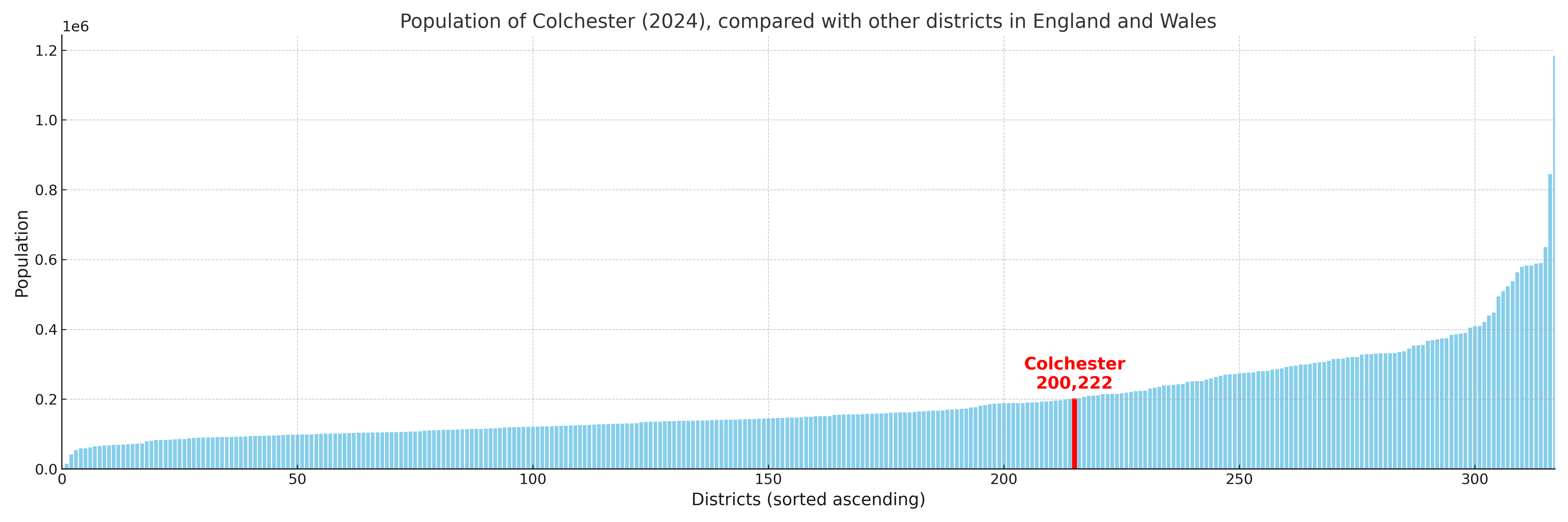
Colchester compared with other districts in the UK
This section shows how Colchester compares with other local authority districts in the UK, using a variety of measures and rankings.
Colchester has 17 electoral wards.

Colchester has a population of 200,222 (2024 mid-year estimate by ONS)
Population and Migration Trends in Colchester
This chart shows the population trend for Colchester from 2015 to 2024. It provides a quick overview of whether the local authority is growing, stable, or declining over time, and helps set context for the migration patterns shown below.
Population change is influenced by natural change (births minus deaths) and migration. The net migration chart below focuses on migration, separating internal migration (moves within the UK) from international migration (moves to and from abroad). Positive values indicate net inflows, while negative values indicate net outflows. The rate labels (per 1,000 residents) help compare migration intensity across years, even when the population size changes.
More local statistics and data for Colchester can be found on the ONS statistics for Colchester.
Latest news about Colchester
Use the search box, or suggested search phrases, below to find recent news, council updates, planning stories, housing developments, transport changes, public services news, local elections, community issues and other local developments related to Colchester. Results may include coverage from UK national, regional and local news websites, as well as official public-sector and local democracy sources.
- Colchester council
- Colchester planning
- Colchester local elections
- Colchester housing
- Colchester transport
- Colchester regeneration
- Colchester public services