East Cambridgeshire
§ This page gives an overview of the East Cambridgeshire local authority district, bringing together key facts, maps, and data to help you quickly understand the area. This is one of 361 LAD profiles on Baseview.
Overview ⁞ East Cambridgeshire stretches across a largely rural landscape of open fields, waterways, and fenland, with Ely as its historic heart. Ely, crowned by its magnificent cathedral known as the “Ship of the Fens,” is a compact city surrounded by flat expanses and waterways such as the River Great Ouse, which flows through the district. Picturesque villages like Burwell, Soham, and Littleport showcase traditional architecture and community charm. The district’s landscape is defined by agricultural land and wetlands, with Wicken Fen standing out as one of Britain’s oldest nature reserves, home to rare wildlife and walking trails. Proximity to Cambridge adds to its appeal, while its tranquil countryside offers a quieter pace of life.
East Cambridgeshire Boundary Map
This map shows the official boundary of the East Cambridgeshire local authority district, based on the latest geographic data published by the Office for National Statistics (ONS). It provides a clear view of the district’s extent and helps you understand how the area fits within the wider regional and national landscape.
Contains OS data © Crown copyright and database right 2025. Source: Office for National Statistics licensed under the Open Government Licence v3.0.
The administrative boundary of East Cambridgeshire can also be viewed on OpenStreetMap: District Boundary of East Cambridgeshire.
Key Facts about East Cambridgeshire
What region is East Cambridgeshire in? East Cambridgeshire is in the East of England of England, a region within the UK.
What county is East Cambridgeshire in? East Cambridgeshire is located in the county of Cambridgeshire.
Is East Cambridgeshire a city? Yes, East Cambridgeshire is a city. East Cambridgeshire holds official city status as one of the 76 designated cities in the UK.
Who governs East Cambridgeshire? The local authority for this district is: East Cambridgeshire District Council - responsible for district-level services. Since Cambridgeshire is a two-tier area, county-level services are handled by: Cambridgeshire County Council.
▶ Official website of East Cambridgeshire District Council 🔗 eastcambs.gov.uk
Which police force covers East Cambridgeshire? Policing in East Cambridgeshire is provided by Cambridgeshire Constabulary 🔗 cambs.police.uk, which serves 6 local authority districts: Cambridge ⁞ East Cambridgeshire ⁞ Fenland ⁞ Huntingdonshire ⁞ Peterborough ⁞ South Cambridgeshire.
Constituencies in East Cambridgeshire
East Cambridgeshire is divided into 1 parliamentary constituencies, listed below in alphabetical order.
A constituency is a specific geographical area that elects one Member of Parliament (MP) to represent them in the House of Commons. The United Kingdom is divided into 650 parliamentary constituencies. We have this list page for easy browsing of all UK parliamentary constituencies: List of Constituencies.
Wards in East Cambridgeshire
East Cambridgeshire is divided into 14 wards, listed below in alphabetical order.
- Bottisham
- Burwell
- Downham Villages
- Ely East
- Ely North
- Ely West
- Fordham & Isleham
- Haddenham
- Littleport
- Soham North
- Soham South
- Stretham
- Sutton
- Woodditton
In the UK, a ward is a subdivision of a local authority area, used mainly for electoral and statistical purposes. Defined by the ONS, wards represent the primary unit for local elections, each returning one or more councillors to the local council. Wards are also used as a key geography for presenting population and census data. We have this list page for easy browsing of all electoral wards: List of all Electoral Wards in the UK.
Parishes in East Cambridgeshire
East Cambridgeshire is fully parished: 35 civil parishes, listed A-Z below.
- Ashley
- Bottisham
- Brinkley
- Burrough Green
- Burwell
- Cheveley
- Chippenham
- Coveney
- Downham
- Dullingham
- Ely
- Fordham
- Haddenham
- Isleham
- Kennett
- Kirtling
- Littleport
- Lode
- Mepal
- Reach
- Snailwell
- Soham
- Stetchworth
- Stretham
- Sutton
- Swaffham Bulbeck
- Swaffham Prior
- Thetford
- Wentworth
- Westley Waterless
- Wicken
- Wilburton
- Witcham
- Witchford
- Woodditton
A civil parish is the lowest tier of local government in England, used for villages, small towns, and suburbs. They have their own local authority, either a parish council or a parish meeting, which provides local services like managing parks, allotments, and streetlights, and represents the community's views to larger councils.
We have this list page for easy browsing of all parishes: List of Civil Parishes in England and Wales.
Post Towns in East Cambridgeshire
Below is a list of post towns in East Cambridgeshire, grouped by postcode area:
CB ▸ Ely (CB6 / CB7)
The UK postal hierarchy begins with broad postcode areas (such as “CB” or “M”), which are divided into smaller postcode districts (such as “CB8” or “M1”) to support accurate mail routing. Each postal address is anchored by a designated post town, the official locality name used in the UK postcode system, which operates independently from Local Authority Districts —the administrative boundaries used for council tax and local government services. Because they serve different purposes, a property’s postal address and its local authority district do not always align exactly.
Built-up Areas in East Cambridgeshire
East Cambridgeshire covers 39 built-up areas, listed below in alphabetical order.
- Ashley (East Cambridgeshire) *
- Bottisham
- Brinkley *
- Burrough Green
- Burwell
- Cheveley
- Chippenham (East Cambridgeshire)
- Chittering
- Coveney
- Down Field
- Earith *
- Ely
- Fordham (East Cambridgeshire)
- Haddenham (East Cambridgeshire)
- Isleham
- Kentford *
- Landwade *
- Little Downham
- Little Thetford
- Littleport
- Lode
- Mepal
- Newmarket *
- Prickwillow
- Pymoor
- Red Lodge *
- Snailwell *
- Soham
- Stetchworth
- Stretham
- Sutton (East Cambridgeshire)
- Swaffham Bulbeck
- Swaffham Prior
- Wardy Hill *
- Wenny Severals *
- Wicken
- Wilburton
- Witcham
- Witchford
In the UK, a Built-up Area (BUA) is a continuous urban area of at least 20 hectares (0.2 km²), defined by the ONS as land where buildings are generally no more than 200 metres apart, such as towns, cities, or large villages. (Note: A BUA name marked with an asterisk (*) indicates that the area is situated partly in the district of East Cambridgeshire.)
We have this list page for easy browsing of all built-up areas: List of all Built-up Areas in GB.
Railway Stations in East Cambridgeshire
East Cambridgeshire is served by a number of National Rail stations, providing rail connections to nearby towns, cities, and destinations across Great Britain. The railway stations listed below are located within the East Cambridgeshire Local Authority District and are grouped by train operating company for clarity.
- Govia Thameslink Railway (Great Northern) ▸ Littleport (CB6 1JL)
- Greater Anglia ▸ Ely (CB7 4BS) ⁞ Soham (CB7 5DY) ⁞ Kennett (CB8 7QD) ⁞ Shippea Hill (CB7 4SR)
This is a district-level view only. For a complete list of all National Rail stations across Great Britain, see the UK National Rail Stations Directory.
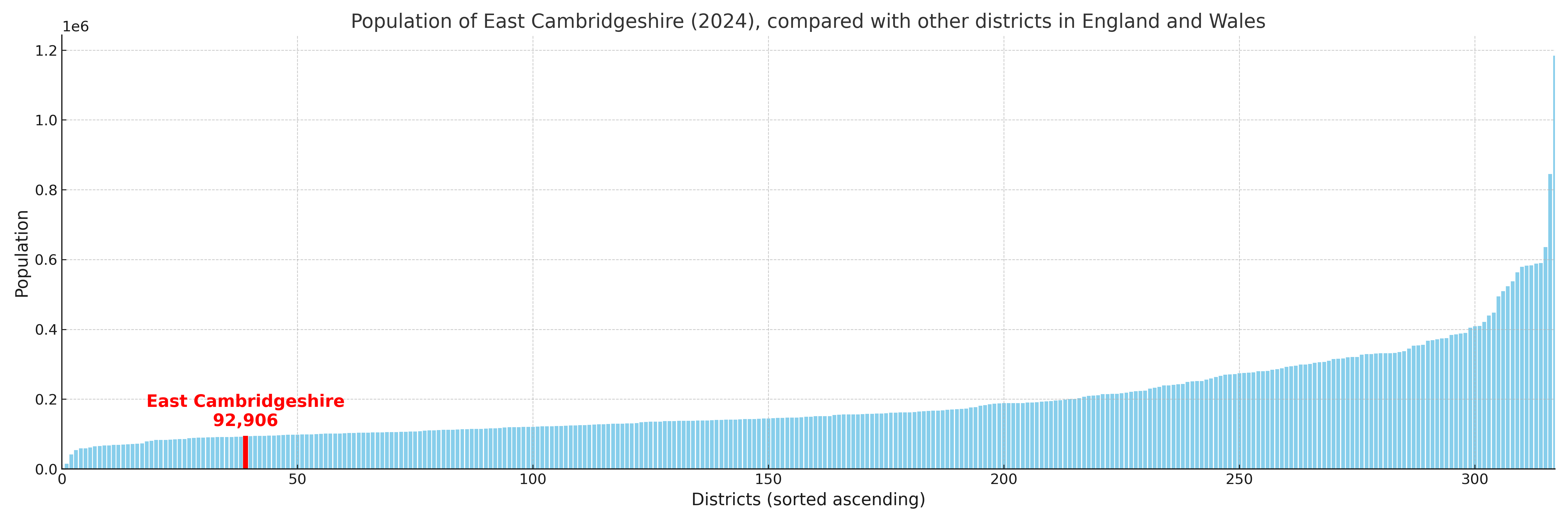
East Cambridgeshire compared with other districts in the UK
This section shows how East Cambridgeshire compares with other local authority districts in the UK, using a variety of measures and rankings.
East Cambridgeshire has 14 electoral wards.

East Cambridgeshire has a population of 92,906 (2024 mid-year estimate by ONS)
Population and Migration Trends in East Cambridgeshire
This chart shows the population trend for East Cambridgeshire from 2015 to 2024. It provides a quick overview of whether the local authority is growing, stable, or declining over time, and helps set context for the migration patterns shown below.
Population change is influenced by natural change (births minus deaths) and migration. The net migration chart below focuses on migration, separating internal migration (moves within the UK) from international migration (moves to and from abroad). Positive values indicate net inflows, while negative values indicate net outflows. The rate labels (per 1,000 residents) help compare migration intensity across years, even when the population size changes.
More local statistics and data for East Cambridgeshire can be found on the ONS statistics for East Cambridgeshire.
Latest news about East Cambridgeshire
Use the search box, or suggested search phrases, below to find recent news, council updates, planning stories, housing developments, transport changes, public services news, local elections, community issues and other local developments related to East Cambridgeshire. Results may include coverage from UK national, regional and local news websites, as well as official public-sector and local democracy sources.
- East Cambridgeshire council
- East Cambridgeshire planning
- East Cambridgeshire local elections
- East Cambridgeshire housing
- East Cambridgeshire transport
- East Cambridgeshire regeneration
- East Cambridgeshire public services