Epping Forest
§ This page gives an overview of the Epping Forest local authority district, bringing together key facts, maps, and data to help you quickly understand the area. This is one of 361 LAD profiles on Baseview.
Overview ⁞ Epping Forest district stretches across west Essex, with the ancient woodland of Epping Forest at its heart. This vast forest, once a royal hunting ground, offers miles of walking and cycling trails, ponds, and wildlife habitats. Towns such as Loughton, Epping, and Waltham Abbey provide historic centres and access to green spaces, while the Lee Valley Park extends into the district with riverside trails and reservoirs. The district includes a mix of suburban areas, market towns, and countryside, with strong ties to London given its location on the capital’s fringe. Its blend of heritage, woodland, and open land makes it unique.
Epping Forest Boundary Map
This map shows the official boundary of the Epping Forest local authority district, based on the latest geographic data published by the Office for National Statistics (ONS). It provides a clear view of the district’s extent and helps you understand how the area fits within the wider regional and national landscape.
Contains OS data © Crown copyright and database right 2025. Source: Office for National Statistics licensed under the Open Government Licence v3.0.
The administrative boundary of Epping Forest can also be viewed on OpenStreetMap: District Boundary of Epping Forest.
Key Facts about Epping Forest
What region is Epping Forest in? Epping Forest is in the East of England of England, a region within the UK.
What county is Epping Forest in? Epping Forest is located in the county of Essex.
Is Epping Forest a city? No, Epping Forest is not a city. (Note: the UK has 76 officially designated cities.)
Who governs Epping Forest? The local authority for this district is: Epping Forest District Council - responsible for district-level services. Since Essex is a two-tier area, county-level services are handled by: Essex County Council.
▶ Official website of Epping Forest District Council 🔗 eppingforestdc.gov.uk
Which police force covers Epping Forest? Policing in Epping Forest is provided by Essex Police 🔗 essex.police.uk, which serves 14 local authority districts: Basildon ⁞ Braintree ⁞ Brentwood ⁞ Castle Point ⁞ Chelmsford ⁞ Colchester ⁞ Epping Forest ⁞ Harlow ⁞ Maldon ⁞ Rochford ⁞ Southend-on-Sea ⁞ Tendring ⁞ Thurrock ⁞ Uttlesford.
Constituencies in Epping Forest
Epping Forest is divided into 3 parliamentary constituencies, listed below in alphabetical order.
A constituency is a specific geographical area that elects one Member of Parliament (MP) to represent them in the House of Commons. The United Kingdom is divided into 650 parliamentary constituencies. We have this list page for easy browsing of all UK parliamentary constituencies: List of Constituencies.
Wards in Epping Forest
Epping Forest is divided into 18 wards, listed below in alphabetical order.
- Buckhurst Hill East & Whitebridge
- Buckhurst Hill West
- Chigwell with Lambourne
- Epping East
- Epping West & Rural
- Grange Hill
- Loughton Fairmead
- Loughton Forest
- Loughton Roding
- Loughton St John's
- North Weald Bassett
- Ongar
- Roydon & Lower Nazeing
- Rural East
- Theydon Bois with Passingford
- Waltham Abbey North
- Waltham Abbey South & Rural
- Waltham Abbey West
In the UK, a ward is a subdivision of a local authority area, used mainly for electoral and statistical purposes. Defined by the ONS, wards represent the primary unit for local elections, each returning one or more councillors to the local council. Wards are also used as a key geography for presenting population and census data. We have this list page for easy browsing of all electoral wards: List of all Electoral Wards in the UK.
Parishes in Epping Forest
Epping Forest is part-parished: 28 civil parishes (listed A-Z below) alongside 2 unparished areas.
- Abbess Beauchamp and Berners Roding
- Bobbingworth
- Buckhurst Hill
- Chigwell
- Epping
- Epping Upland
- Fyfield
- High Laver
- High Ongar
- Lambourne
- Little Laver
- Loughton
- Magdalen Laver
- Matching
- Moreton
- Nazeing
- North Weald Bassett
- Ongar
- Roydon
- Sheering
- Stanford Rivers
- Stapleford Abbotts
- Stapleford Tawney
- Theydon Bois
- Theydon Garnon
- Theydon Mount
- Waltham Abbey
- Willingale
A civil parish is the lowest tier of local government in England, used for villages, small towns, and suburbs. They have their own local authority, either a parish council or a parish meeting, which provides local services like managing parks, allotments, and streetlights, and represents the community's views to larger councils.
We have this list page for easy browsing of all parishes: List of Civil Parishes in England and Wales.
Post Towns in Epping Forest
Below is a list of post towns in Epping Forest, grouped by postcode area:
- CM ▸ Epping (CM16) ⁞ Ongar (CM5)
- EN ▸ Waltham Abbey (EN9)
- IG ▸ Buckhurst Hill (IG9) ⁞ Loughton (IG10)
The UK postal hierarchy begins with broad postcode areas (such as “CB” or “M”), which are divided into smaller postcode districts (such as “CB8” or “M1”) to support accurate mail routing. Each postal address is anchored by a designated post town, the official locality name used in the UK postcode system, which operates independently from Local Authority Districts —the administrative boundaries used for council tax and local government services. Because they serve different purposes, a property’s postal address and its local authority district do not always align exactly.
Built-up Areas in Epping Forest
Epping Forest covers 35 built-up areas, listed below in alphabetical order.
- Abridge
- Broadley Common
- Buckhurst Hill *
- Bumble's Green
- Chigwell *
- Chigwell Row
- Chipping Ongar
- Coopersale
- Enfield *
- Epping
- Epping Upland
- Fyfield
- Harlow *
- High Beech
- Hoddesdon *
- Loughton
- Lower Nazeing
- Matching Green
- Moreton (Epping Forest)
- Nazeing
- North Weald Bassett
- Paslow Wood Common *
- Redbridge *
- Roydon (Epping Forest) *
- Roydon Hamlet
- Sawbridgeworth *
- Sewardstone
- Sheering *
- Shelley (Epping Forest)
- Stapleford Abbotts *
- Theydon Bois
- Thornwood Common
- Waltham Abbey
- Waltham Cross *
- Waltham Forest *
In the UK, a Built-up Area (BUA) is a continuous urban area of at least 20 hectares (0.2 km²), defined by the ONS as land where buildings are generally no more than 200 metres apart, such as towns, cities, or large villages. (Note: A BUA name marked with an asterisk (*) indicates that the area is situated partly in the district of Epping Forest.)
We have this list page for easy browsing of all built-up areas: List of all Built-up Areas in GB.
Epping Forest compared with other districts in the UK
This section shows how Epping Forest compares with other local authority districts in the UK, using a variety of measures and rankings.
Epping Forest has 18 electoral wards.

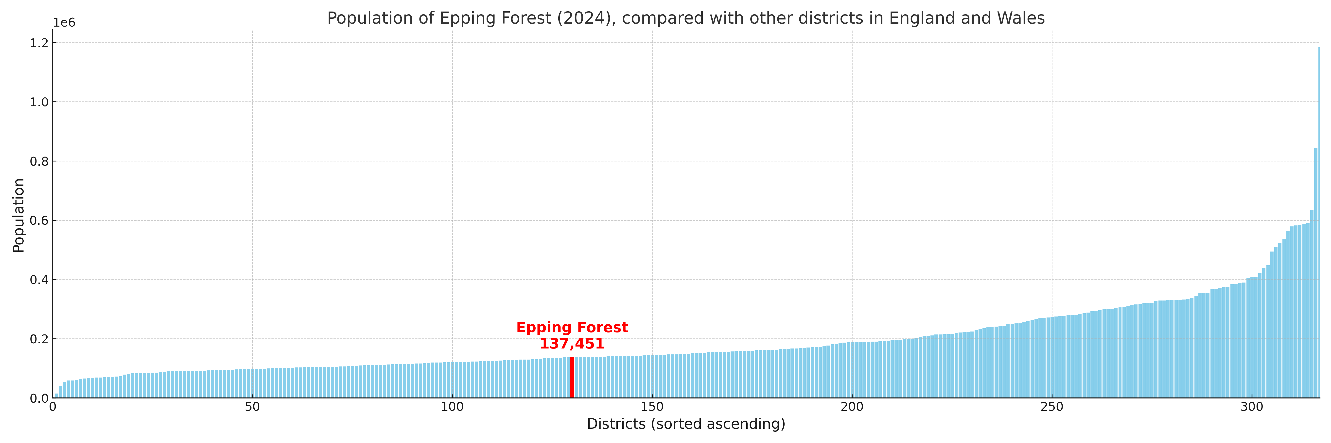
Epping Forest has a population of 137,451 (2024 mid-year estimate by ONS)
Population and Migration Trends in Epping Forest
This chart shows the population trend for Epping Forest from 2015 to 2024. It provides a quick overview of whether the local authority is growing, stable, or declining over time, and helps set context for the migration patterns shown below.
Population change is influenced by natural change (births minus deaths) and migration. The net migration chart below focuses on migration, separating internal migration (moves within the UK) from international migration (moves to and from abroad). Positive values indicate net inflows, while negative values indicate net outflows. The rate labels (per 1,000 residents) help compare migration intensity across years, even when the population size changes.
More local statistics and data for Epping Forest can be found on the ONS statistics for Epping Forest.
Latest news about Epping Forest
Use the search box, or suggested search phrases, below to find recent news, council updates, planning stories, housing developments, transport changes, public services news, local elections, community issues and other local developments related to Epping Forest. Results may include coverage from UK national, regional and local news websites, as well as official public-sector and local democracy sources.
- Epping Forest council
- Epping Forest planning
- Epping Forest local elections
- Epping Forest housing
- Epping Forest transport
- Epping Forest regeneration
- Epping Forest public services