Maldon
§ This page gives an overview of the Maldon local authority district, bringing together key facts, maps, and data to help you quickly understand the area. This is one of 361 LAD profiles on Baseview.
Overview ⁞ Maldon, on the Blackwater Estuary in Essex, is renowned for its maritime heritage and sea salt production. The town of Maldon itself has a historic High Street, the Hythe Quay with Thames sailing barges, and Promenade Park overlooking the estuary. Surrounding villages such as Heybridge and Burnham-on-Crouch on the Dengie Peninsula add coastal charm with sailing clubs and marshland landscapes. The estuary’s mudflats and saltmarshes provide important habitats for wildlife and attract walkers and birdwatchers. Maldon’s mix of coastal scenery, sailing traditions, and historic towns defines its character.
Maldon Boundary Map
This map shows the official boundary of the Maldon local authority district, based on the latest geographic data published by the Office for National Statistics (ONS). It provides a clear view of the district’s extent and helps you understand how the area fits within the wider regional and national landscape.
Contains OS data © Crown copyright and database right 2025. Source: Office for National Statistics licensed under the Open Government Licence v3.0.
The administrative boundary of Maldon can also be viewed on OpenStreetMap: District Boundary of Maldon.
Key Facts about Maldon
What region is Maldon in? Maldon is in the East of England of England, a region within the UK.
What county is Maldon in? Maldon is located in the county of Essex.
Is Maldon a city? No, Maldon is not a city. (Note: the UK has 76 officially designated cities.)
Who governs Maldon? The local authority for this district is: Maldon District Council - responsible for district-level services. Since Essex is a two-tier area, county-level services are handled by: Essex County Council.
▶ Official website of Maldon District Council 🔗 maldon.gov.uk
Which police force covers Maldon? Policing in Maldon is provided by Essex Police 🔗 essex.police.uk, which serves 14 local authority districts: Basildon ⁞ Braintree ⁞ Brentwood ⁞ Castle Point ⁞ Chelmsford ⁞ Colchester ⁞ Epping Forest ⁞ Harlow ⁞ Maldon ⁞ Rochford ⁞ Southend-on-Sea ⁞ Tendring ⁞ Thurrock ⁞ Uttlesford.
Constituencies in Maldon
Maldon is divided into 2 parliamentary constituencies, listed below in alphabetical order.
A constituency is a specific geographical area that elects one Member of Parliament (MP) to represent them in the House of Commons. The United Kingdom is divided into 650 parliamentary constituencies. We have this list page for easy browsing of all UK parliamentary constituencies: List of Constituencies.
Wards in Maldon
Maldon is divided into 17 wards, listed below in alphabetical order.
- Althorne
- Burnham-on-Crouch North
- Burnham-on-Crouch South
- Great Totham
- Heybridge East
- Heybridge West
- Maldon East
- Maldon North
- Maldon South
- Maldon West
- Mayland
- Purleigh
- Southminster
- Tillingham
- Tollesbury
- Tolleshunt D'Arcy
- Wickham Bishops and Woodham
In the UK, a ward is a subdivision of a local authority area, used mainly for electoral and statistical purposes. Defined by the ONS, wards represent the primary unit for local elections, each returning one or more councillors to the local council. Wards are also used as a key geography for presenting population and census data. We have this list page for easy browsing of all electoral wards: List of all Electoral Wards in the UK.
Parishes in Maldon
Maldon is fully parished: 34 civil parishes, listed A-Z below.
- Althorne
- Asheldham
- Bradwell-on-Sea
- Burnham-on-Crouch
- Cold Norton
- Dengie
- Goldhanger
- Great Braxted
- Great Totham
- Hazeleigh
- Heybridge
- Heybridge Basin
- Langford
- Latchingdon
- Little Braxted
- Little Totham
- Maldon
- Mayland
- Mundon
- North Fambridge
- Purleigh
- Southminster
- St. Lawrence
- Steeple
- Stow Maries
- Tillingham
- Tollesbury
- Tolleshunt D'Arcy
- Tolleshunt Knights
- Tolleshunt Major
- Ulting
- Wickham Bishops
- Woodham Mortimer
- Woodham Walter
A civil parish is the lowest tier of local government in England, used for villages, small towns, and suburbs. They have their own local authority, either a parish council or a parish meeting, which provides local services like managing parks, allotments, and streetlights, and represents the community's views to larger councils.
We have this list page for easy browsing of all parishes: List of Civil Parishes in England and Wales.
Post Towns in Maldon
Below is a list of post towns in Maldon, grouped by postcode area:
- CM ▸ Burnham-on-Crouch (CM0) ⁞ Maldon (CM9) ⁞ Southminster (CM0)
The UK postal hierarchy begins with broad postcode areas (such as “CB” or “M”), which are divided into smaller postcode districts (such as “CB8” or “M1”) to support accurate mail routing. Each postal address is anchored by a designated post town, the official locality name used in the UK postcode system, which operates independently from Local Authority Districts —the administrative boundaries used for council tax and local government services. Because they serve different purposes, a property’s postal address and its local authority district do not always align exactly.
Built-up Areas in Maldon
Maldon covers 27 built-up areas, listed below in alphabetical order.
- Althorne
- Burnham-on-Crouch
- Cold Norton (Maldon)
- Danbury *
- Gay Bowers *
- Goldhanger
- Great Totham
- Heybridge Basin
- Langford (Maldon)
- Latchingdon
- Little Totham
- Maldon
- Mayland
- North Fambridge
- Purleigh
- Ramsey Island
- Southminster
- Steeple
- Stoneyhills
- Tillingham
- Tiptree *
- Tollesbury
- Tolleshunt D'Arcy
- Tolleshunt Knights *
- Tolleshunt Major
- Wickham Bishops
- Woodham Mortimer
In the UK, a Built-up Area (BUA) is a continuous urban area of at least 20 hectares (0.2 km²), defined by the ONS as land where buildings are generally no more than 200 metres apart, such as towns, cities, or large villages. (Note: A BUA name marked with an asterisk (*) indicates that the area is situated partly in the district of Maldon.)
We have this list page for easy browsing of all built-up areas: List of all Built-up Areas in GB.
Railway Stations in Maldon
Maldon is served by a number of National Rail stations, providing rail connections to nearby towns, cities, and destinations across Great Britain. The railway stations listed below are located within the Maldon Local Authority District and are grouped by train operating company for clarity.
- Greater Anglia ▸ Burnham-On-Crouch (CM0 8BQ) ⁞ Southminster (CM0 7EN) ⁞ North Fambridge (CM3 6NP) ⁞ Althorne (Essex) (CM3 6DG)
This is a district-level view only. For a complete list of all National Rail stations across Great Britain, see the UK National Rail Stations Directory.
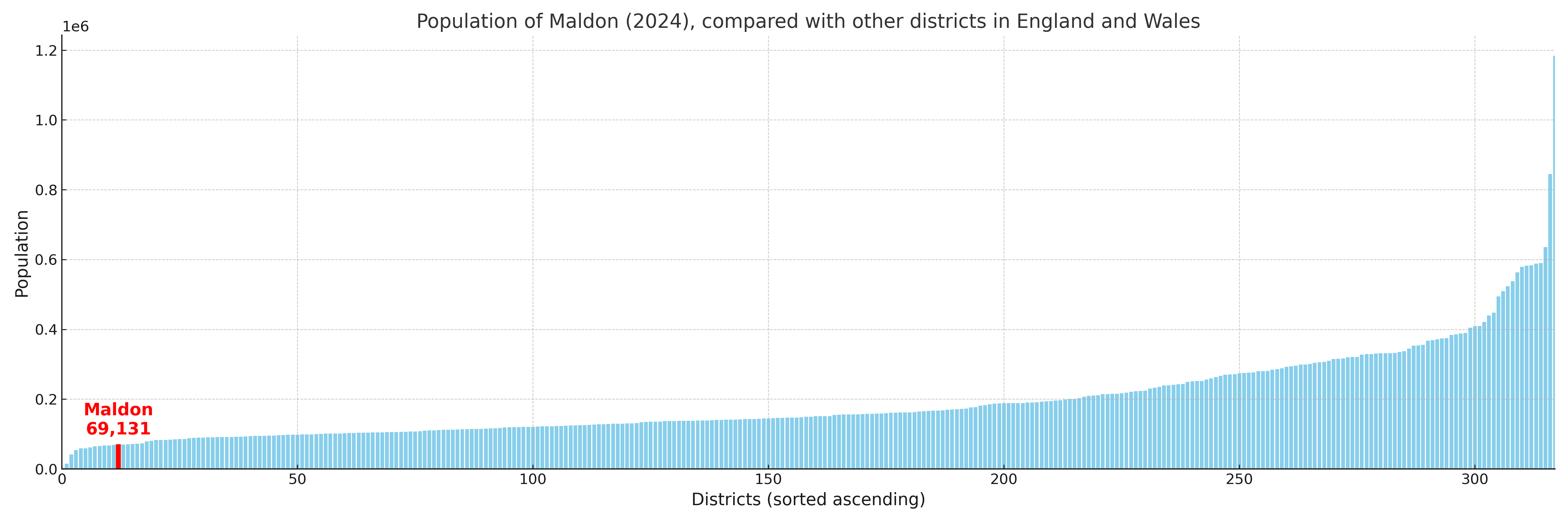
Maldon compared with other districts in the UK
This section shows how Maldon compares with other local authority districts in the UK, using a variety of measures and rankings.
Maldon has 17 electoral wards.

Maldon has a population of 69,131 (2024 mid-year estimate by ONS)
Population and Migration Trends in Maldon
This chart shows the population trend for Maldon from 2015 to 2024. It provides a quick overview of whether the local authority is growing, stable, or declining over time, and helps set context for the migration patterns shown below.
Population change is influenced by natural change (births minus deaths) and migration. The net migration chart below focuses on migration, separating internal migration (moves within the UK) from international migration (moves to and from abroad). Positive values indicate net inflows, while negative values indicate net outflows. The rate labels (per 1,000 residents) help compare migration intensity across years, even when the population size changes.
More local statistics and data for Maldon can be found on the ONS statistics for Maldon.
Latest news about Maldon
Use the search box, or suggested search phrases, below to find recent news, council updates, planning stories, housing developments, transport changes, public services news, local elections, community issues and other local developments related to Maldon. Results may include coverage from UK national, regional and local news websites, as well as official public-sector and local democracy sources.
- Maldon council
- Maldon planning
- Maldon local elections
- Maldon housing
- Maldon transport
- Maldon regeneration
- Maldon public services