Broadland
§ This page gives an overview of the Broadland local authority district, bringing together key facts, maps, and data to help you quickly understand the area. This is one of 361 LAD profiles on Baseview.
Overview ⁞ Broadland, located north of Norwich in Norfolk, takes its name from the famous Norfolk Broads, a network of rivers and lakes. The district’s landscape is a mix of wetlands, farmland, and scattered villages, with boating and wildlife at the heart of its appeal. Market towns such as Aylsham and Acle provide local hubs, while villages like Coltishall and Wroxham serve as gateways to the Broads. Historic churches, mills, and riverside walks dot the area, blending rural charm with unique waterways.
Broadland Boundary Map
This map shows the official boundary of the Broadland local authority district, based on the latest geographic data published by the Office for National Statistics (ONS). It provides a clear view of the district’s extent and helps you understand how the area fits within the wider regional and national landscape.
Contains OS data © Crown copyright and database right 2025. Source: Office for National Statistics licensed under the Open Government Licence v3.0.
The administrative boundary of Broadland can also be viewed on OpenStreetMap: District Boundary of Broadland.
Key Facts about Broadland
What region is Broadland in? Broadland is in the East of England of England, a region within the UK.
What county is Broadland in? Broadland is located in the county of Norfolk.
Is Broadland a city? No, Broadland is not a city. (Note: the UK has 76 officially designated cities.)
Who governs Broadland? The local authority for this district is: Broadland District Council - responsible for district-level services. Since Norfolk is a two-tier area, county-level services are handled by: Norfolk County Council.
▶ Official website of Broadland District Council 🔗 southnorfolkandbroadland.gov.uk
Which police force covers Broadland? Policing in Broadland is provided by Norfolk Constabulary 🔗 norfolk.police.uk, which serves 7 local authority districts: Breckland ⁞ Broadland ⁞ Great Yarmouth ⁞ King's Lynn and West Norfolk ⁞ North Norfolk ⁞ Norwich ⁞ South Norfolk.
Constituencies in Broadland
Broadland is divided into 2 parliamentary constituencies, listed below in alphabetical order.
A constituency is a specific geographical area that elects one Member of Parliament (MP) to represent them in the House of Commons. The United Kingdom is divided into 650 parliamentary constituencies. We have this list page for easy browsing of all UK parliamentary constituencies: List of Constituencies.
Wards in Broadland
Broadland is divided into 27 wards, listed below in alphabetical order.
- Acle
- Aylsham
- Blofield with South Walsham
- Brundall
- Burlingham
- Buxton
- Coltishall
- Drayton North
- Drayton South
- Eynesford
- Great Witchingham
- Hellesdon North West
- Hellesdon South East
- Hevingham
- Horsford and Felthorpe
- Marshes
- Old Catton and Sprowston West
- Plumstead
- Reepham
- Spixworth with St Faiths
- Sprowston Central
- Sprowston East
- Taverham North
- Taverham South
- Thorpe St Andrew North West
- Thorpe St Andrew South East
- Wroxham
In the UK, a ward is a subdivision of a local authority area, used mainly for electoral and statistical purposes. Defined by the ONS, wards represent the primary unit for local elections, each returning one or more councillors to the local council. Wards are also used as a key geography for presenting population and census data. We have this list page for easy browsing of all electoral wards: List of all Electoral Wards in the UK.
Parishes in Broadland
Broadland is part-parished: 65 civil parishes (listed A-Z below) alongside 1 unparished areas.
- Acle
- Alderford
- Attlebridge
- Aylsham
- Beeston St. Andrew
- Beighton
- Belaugh
- Blickling
- Blofield
- Booton
- Brampton
- Brandiston
- Brundall
- Burgh and Tuttington
- Buxton with Lammas
- Cantley, Limpenhoe and Southwood
- Cawston
- Coltishall
- Crostwick
- Drayton
- Felthorpe
- Foulsham
- Freethorpe
- Frettenham
- Great and Little Plumstead
- Great Witchingham
- Guestwick
- Hainford
- Halvergate
- Haveringland
- Hellesdon
- Hemblington
- Hevingham
- Heydon
- Honingham
- Horsford
- Horsham St. Faith and Newton St. Faith
- Horstead with Stanninghall
- Lingwood and Burlingham
- Little Witchingham
- Marsham
- Morton on the Hill
- Old Catton
- Oulton
- Postwick with Witton
- Rackheath
- Reedham
- Reepham
- Ringland
- Salhouse
- Salle
- South Walsham
- Spixworth
- Sprowston
- Stratton Strawless
- Strumpshaw
- Swannington
- Taverham
- Themelthorpe
- Thorpe St. Andrew
- Upton with Fishley
- Weston Longville
- Wood Dalling
- Woodbastwick
- Wroxham
A civil parish is the lowest tier of local government in England, used for villages, small towns, and suburbs. They have their own local authority, either a parish council or a parish meeting, which provides local services like managing parks, allotments, and streetlights, and represents the community's views to larger councils.
We have this list page for easy browsing of all parishes: List of Civil Parishes in England and Wales.
Built-up Areas in Broadland
Broadland covers 48 built-up areas, listed below in alphabetical order.
- Acle
- Aylsham
- Badersfield *
- Blofield
- Blofield Heath
- Brundall *
- Buxton (Broadland)
- Cantley *
- Cawston (Broadland)
- Coltishall and Horstead
- Colton (South Norfolk) *
- Costessey *
- Damgate
- Easton (Broadland) *
- Felthorpe
- Foulsham
- Freethorpe
- Frettenham
- Hainford
- Halvergate
- Haveringland
- Hevingham
- Honingham
- Horning *
- Horsford
- Horsham St Faith
- Hoveton and Wroxham *
- Lenwade
- Lingwood
- Little Plumstead
- Marsham
- Morton (Broadland)
- Newton St Faith
- Norwich *
- Postwick
- Queen's Hills *
- Rackheath
- Reedham *
- Reepham (Broadland)
- Salhouse
- South Walsham
- Spixworth
- Strumpshaw
- Taverham and Drayton *
- Thorpe End
- Upton (Broadland)
- Waterloo
- Weston Green *
In the UK, a Built-up Area (BUA) is a continuous urban area of at least 20 hectares (0.2 km²), defined by the ONS as land where buildings are generally no more than 200 metres apart, such as towns, cities, or large villages. (Note: A BUA name marked with an asterisk (*) indicates that the area is situated partly in the district of Broadland.)
We have this list page for easy browsing of all built-up areas: List of all Built-up Areas in GB.
Railway Stations in Broadland
Broadland is served by a number of National Rail stations, providing rail connections to nearby towns, cities, and destinations across Great Britain. The railway stations listed below are located within the Broadland Local Authority District and are grouped by train operating company for clarity.
- Greater Anglia ▸ Brundall (NR13 5LA) ⁞ Lingwood (NR13 4AU) ⁞ Acle (NR13 3BZ) ⁞ Reedham (Norfolk) (NR13 3JF) ⁞ Cantley (NR13 3SQ) ⁞ Brundall Gardens (NR13 5RG) ⁞ Salhouse (NR13 6NZ) ⁞ Berney Arms (NR30 1SB) ⁞ Buckenham (NR13 4HW)
This is a district-level view only. For a complete list of all National Rail stations across Great Britain, see the UK National Rail Stations Directory.
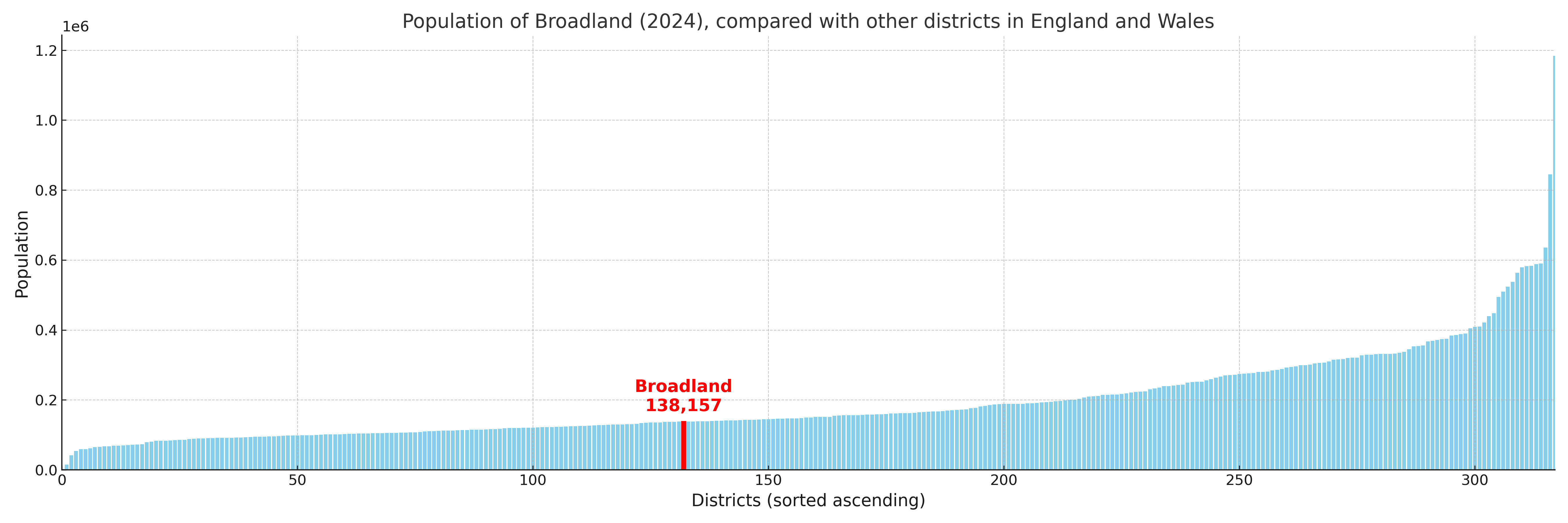
Broadland compared with other districts in the UK
This section shows how Broadland compares with other local authority districts in the UK, using a variety of measures and rankings.
Broadland has 27 electoral wards.

Broadland has a population of 138,157 (2024 mid-year estimate by ONS)
Population and Migration Trends in Broadland
This chart shows the population trend for Broadland from 2015 to 2024. It provides a quick overview of whether the local authority is growing, stable, or declining over time, and helps set context for the migration patterns shown below.
Population change is influenced by natural change (births minus deaths) and migration. The net migration chart below focuses on migration, separating internal migration (moves within the UK) from international migration (moves to and from abroad). Positive values indicate net inflows, while negative values indicate net outflows. The rate labels (per 1,000 residents) help compare migration intensity across years, even when the population size changes.
More local statistics and data for Broadland can be found on the ONS statistics for Broadland.
Latest news about Broadland
Use the search box, or suggested search phrases, below to find recent news, council updates, planning stories, housing developments, transport changes, public services news, local elections, community issues and other local developments related to Broadland. Results may include coverage from UK national, regional and local news websites, as well as official public-sector and local democracy sources.
- Broadland council
- Broadland planning
- Broadland local elections
- Broadland housing
- Broadland transport
- Broadland regeneration
- Broadland public services