South Norfolk
§ This page gives an overview of the South Norfolk local authority district, bringing together key facts, maps, and data to help you quickly understand the area. This is one of 361 LAD profiles on Baseview.
Overview ⁞ South Norfolk is a largely rural district surrounding Norwich, characterised by farmland, woodlands, and traditional villages. Market towns like Diss, Wymondham, and Harleston are key centres, with historic churches, abbeys, and bustling markets. The River Waveney forms part of its southern boundary, offering scenic landscapes and wildlife. The countryside is dotted with flint cottages, windmills, and walking routes, while the area’s proximity to Norwich adds to its appeal.
South Norfolk Boundary Map
This map shows the official boundary of the South Norfolk local authority district, based on the latest geographic data published by the Office for National Statistics (ONS). It provides a clear view of the district’s extent and helps you understand how the area fits within the wider regional and national landscape.
Contains OS data © Crown copyright and database right 2025. Source: Office for National Statistics licensed under the Open Government Licence v3.0.
The administrative boundary of South Norfolk can also be viewed on OpenStreetMap: District Boundary of South Norfolk.
Key Facts about South Norfolk
What region is South Norfolk in? South Norfolk is in the East of England of England, a region within the UK.
What county is South Norfolk in? South Norfolk is located in the county of Norfolk.
Is South Norfolk a city? No, South Norfolk is not a city. (Note: the UK has 76 officially designated cities.)
Who governs South Norfolk? The local authority for this district is: South Norfolk District Council - responsible for district-level services. Since Norfolk is a two-tier area, county-level services are handled by: Norfolk County Council.
▶ Official website of South Norfolk District Council 🔗 southnorfolkandbroadland.gov.uk
Which police force covers South Norfolk? Policing in South Norfolk is provided by Norfolk Constabulary 🔗 norfolk.police.uk, which serves 7 local authority districts: Breckland ⁞ Broadland ⁞ Great Yarmouth ⁞ King's Lynn and West Norfolk ⁞ North Norfolk ⁞ Norwich ⁞ South Norfolk.
South Norfolk in International Geographies
In the International Territorial Levels (ITLs) hierarchy, South Norfolk is within an ITLs Level 3 area:
- (ITL 1) East of England
- (ITL 2) ⇒ Norfolk
- (ITL 3) ⇒⇒ Breckland and South Norfolk
The International Territorial Levels are used by OECD member countries for statistical purposes to classify administrative areas. We have this listable page for easy browsing of ITL names and codes: International Territorial Levels.
Constituencies in South Norfolk
South Norfolk is divided into 4 parliamentary constituencies, listed below in alphabetical order.
A constituency is a specific geographical area that elects one Member of Parliament (MP) to represent them in the House of Commons. The United Kingdom is divided into 650 parliamentary constituencies. We have this list page for easy browsing of all UK parliamentary constituencies: List of Constituencies.
Wards in South Norfolk
South Norfolk is divided into 26 wards, listed below in alphabetical order.
- Beck Vale, Dickleburgh & Scole
- Bressingham & Burston
- Brooke
- Bunwell
- Central Wymondham
- Cringleford
- Diss & Roydon
- Ditchingham & Earsham
- Easton
- Forncett
- Harleston
- Hempnall
- Hethersett
- Hingham & Deopham
- Loddon & Chedgrave
- Mulbarton & Stoke Holy Cross
- New Costessey
- Newton Flotman
- North Wymondham
- Old Costessey
- Poringland, Framinghams & Trowse
- Rockland
- South Wymondham
- Stratton
- Thurlton
- Wicklewood
In the UK, a ward is a subdivision of a local authority area, used mainly for electoral and statistical purposes. Defined by the ONS, wards represent the primary unit for local elections, each returning one or more councillors to the local council. Wards are also used as a key geography for presenting population and census data. We have this list page for easy browsing of all electoral wards: List of all Electoral Wards in the UK.
Parishes in South Norfolk
South Norfolk is part-parished: 118 civil parishes (listed A-Z below) alongside 1 unparished areas.
- Alburgh
- Aldeby
- Alpington
- Ashby St. Mary
- Ashwellthorpe and Fundenhall
- Aslacton
- Barford
- Barnham Broom
- Bawburgh
- Bedingham
- Bergh Apton
- Bracon Ash
- Bramerton
- Brandon Parva, Coston, Runhall and Welborne
- Bressingham
- Brockdish
- Brooke
- Broome
- Bunwell
- Burgh St. Peter
- Burston and Shimpling
- Caistor St Edmund and Bixley
- Carleton Rode
- Carleton St. Peter
- Chedgrave
- Claxton
- Colney
- Costessey
- Cringleford
- Denton
- Deopham
- Dickleburgh and Rushall
- Diss
- Ditchingham
- Earsham
- East Carleton
- Easton
- Ellingham
- Flordon
- Forncett
- Framingham Earl
- Framingham Pigot
- Geldeston
- Gillingham
- Gissing
- Great Melton
- Great Moulton
- Haddiscoe
- Hales
- Heckingham
- Hedenham
- Hellington
- Hempnall
- Hethersett
- Heywood
- Hingham
- Holverston
- Howe
- Keswick and Intwood
- Ketteringham
- Kimberley and Carleton Forehoe
- Kirby Bedon
- Kirby Cane
- Kirstead
- Langley with Hardley
- Little Melton
- Loddon
- Long Stratton
- Marlingford and Colton
- Morley
- Morningthorpe and Fritton
- Mulbarton
- Mundham
- Needham
- Newton Flotman
- Norton Subcourse
- Poringland
- Pulham Market
- Pulham St. Mary
- Raveningham
- Redenhall with Harleston
- Rockland St. Mary
- Roydon
- Saxlingham Nethergate
- Scole
- Seething
- Shelfanger
- Shelton and Hardwick
- Shotesham
- Sisland
- Spooner Row
- Starston
- Stockton
- Stoke Holy Cross
- Surlingham
- Swainsthorpe
- Swardeston
- Tacolneston
- Tasburgh
- Tharston and Hapton
- Thurlton
- Thurton
- Thwaite
- Tibenham
- Tivetshall
- Toft Monks
- Topcroft
- Trowse with Newton
- Wacton
- Wheatacre
- Wicklewood
- Winfarthing
- Woodton
- Wortwell
- Wramplingham
- Wreningham
- Wymondham
- Yelverton
A civil parish is the lowest tier of local government in England, used for villages, small towns, and suburbs. They have their own local authority, either a parish council or a parish meeting, which provides local services like managing parks, allotments, and streetlights, and represents the community's views to larger councils.
We have this list page for easy browsing of all parishes: List of Civil Parishes in England and Wales.
Post Towns in South Norfolk
Below is a list of post towns in South Norfolk, grouped by postcode area:
- IP ▸ Harleston (IP20)
- NR ▸ Bungay (NR35) ⁞ Wymondham (NR18)
The UK postal hierarchy begins with broad postcode areas (such as “CB” or “M”), which are divided into smaller postcode districts (such as “CB8” or “M1”) to support accurate mail routing. Each postal address is anchored by a designated post town, the official locality name used in the UK postcode system, which operates independently from Local Authority Districts —the administrative boundaries used for council tax and local government services. Because they serve different purposes, a property’s postal address and its local authority district do not always align exactly.
Built-up Areas in South Norfolk
South Norfolk covers 76 built-up areas, listed below in alphabetical order.
- Alburgh Street
- Alpington and Yelverton
- Ashwellthorpe
- Barford (South Norfolk)
- Beccles *
- Bracon Ash
- Bressingham
- Brooke
- Bungay *
- Bunwell
- Burgh St Peter
- Burston
- Chedgrave
- Colney *
- Colton (South Norfolk) *
- Costessey *
- Cringleford *
- Dickleburgh
- Diss *
- Ditchingham
- Earsham *
- Easton (Broadland) *
- Ellingham and Kirby Cane
- Geldeston
- Gillingham (South Norfolk)
- Great Moulton
- Haddiscoe
- Hales
- Harleston
- Hempnall
- Hempnall Green
- Hethersett
- Hingham
- Little Melton
- Loddon
- Long Stratton
- Mattishall *
- Morley St Botolph
- Morley St Peter *
- Mulbarton
- Needham
- Newton Flotman
- Norwich *
- Poringland
- Pulham Market
- Pulham St Mary
- Queen's Hills *
- Reedham *
- Rockland St Mary
- Roydon (South Norfolk)
- Saxlingham Nethergate
- Scole
- Seething
- Shelfanger
- Shotesham
- Sneath Common
- Snow Street
- St Olaves *
- Stoke Holy Cross
- Surlingham
- Swainsthorpe
- Swardeston
- Tacolneston
- Tasburgh
- Taverham and Drayton *
- Thurlton
- Thurton
- Tibenham
- Tivetshall St Mary and Tivetshall St Margaret
- Trowse Newton
- Wacton
- Wicklewood
- Woodton
- Wortwell
- Wreningham
- Wymondham (South Norfolk)
In the UK, a Built-up Area (BUA) is a continuous urban area of at least 20 hectares (0.2 km²), defined by the ONS as land where buildings are generally no more than 200 metres apart, such as towns, cities, or large villages. (Note: A BUA name marked with an asterisk (*) indicates that the area is situated partly in the district of South Norfolk.)
We have this list page for easy browsing of all built-up areas: List of all Built-up Areas in GB.
Railway Stations in South Norfolk
South Norfolk is served by a number of National Rail stations, providing rail connections to nearby towns, cities, and destinations across Great Britain. The railway stations listed below are located within the South Norfolk Local Authority District and are grouped by train operating company for clarity.
- Greater Anglia ▸ Diss (IP22 4HN) ⁞ Wymondham (NR18 0JZ) ⁞ Haddiscoe (NR31 9JA) ⁞ Spooner Row (NR18 9AH)
This is a district-level view only. For a complete list of all National Rail stations across Great Britain, see the UK National Rail Stations Directory.
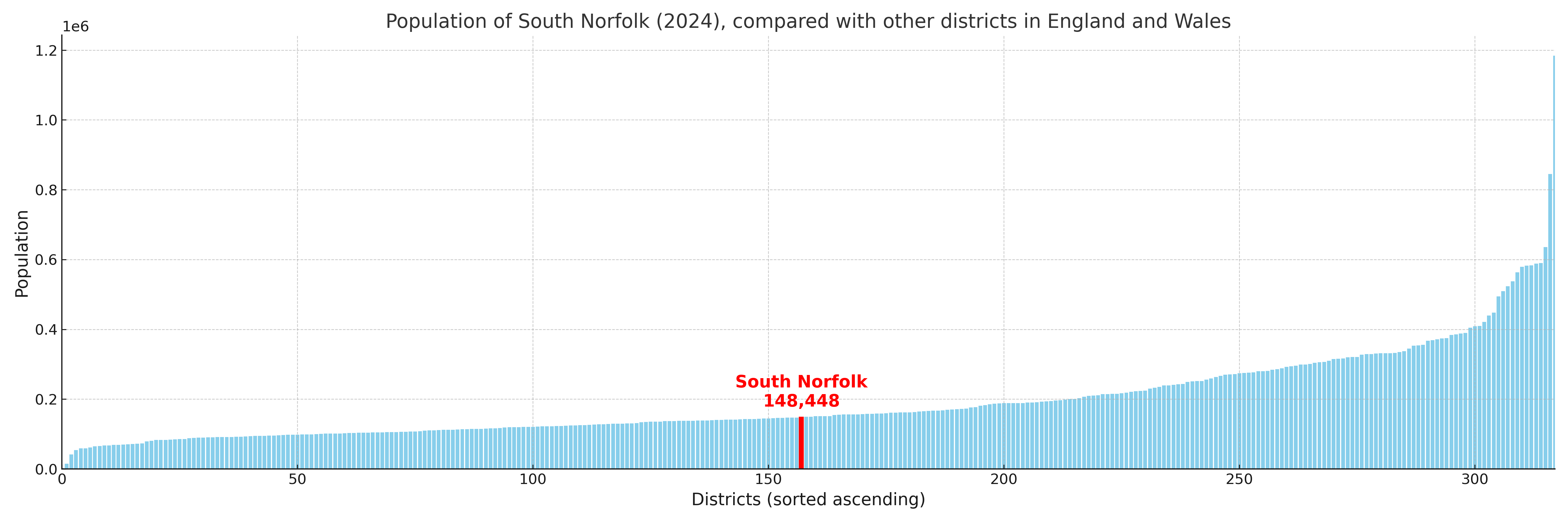
South Norfolk compared with other districts in the UK
This section shows how South Norfolk compares with other local authority districts in the UK, using a variety of measures and rankings.
South Norfolk has 26 electoral wards.

South Norfolk has a population of 148,448 (2024 mid-year estimate by ONS)
Population and Migration Trends in South Norfolk
This chart shows the population trend for South Norfolk from 2015 to 2024. It provides a quick overview of whether the local authority is growing, stable, or declining over time, and helps set context for the migration patterns shown below.
Population change is influenced by natural change (births minus deaths) and migration. The net migration chart below focuses on migration, separating internal migration (moves within the UK) from international migration (moves to and from abroad). Positive values indicate net inflows, while negative values indicate net outflows. The rate labels (per 1,000 residents) help compare migration intensity across years, even when the population size changes.
More local statistics and data for South Norfolk can be found on the ONS statistics for South Norfolk.
Latest news about South Norfolk
Use the search box, or suggested search phrases, below to find recent news, council updates, planning stories, housing developments, transport changes, public services news, local elections, community issues and other local developments related to South Norfolk. Results may include coverage from UK national, regional and local news websites, as well as official public-sector and local democracy sources.
- South Norfolk council
- South Norfolk planning
- South Norfolk local elections
- South Norfolk housing
- South Norfolk transport
- South Norfolk regeneration
- South Norfolk public services