East Suffolk
§ This page gives an overview of the East Suffolk local authority district, bringing together key facts, maps, and data to help you quickly understand the area. This is one of 361 LAD profiles on Baseview.
Overview ⁞ East Suffolk is a coastal district stretching along the North Sea from Lowestoft in the north to Felixstowe in the south, with a landscape defined by estuaries, heaths, and seaside towns. Lowestoft, Britain’s most easterly town, is known for its beaches, maritime heritage, and the Ness Point landmark, while Felixstowe is a lively resort and home to one of Europe’s busiest ports. Inland, market towns such as Woodbridge and Saxmundham preserve historic high streets, while coastal gems like Southwold and Aldeburgh are celebrated for their piers, arts festivals, and seafood traditions. The Suffolk Coast and Heaths Area of Outstanding Natural Beauty encompasses shingle beaches, wetlands, and heathland, with sites such as Orford Ness and RSPB Minsmere attracting wildlife enthusiasts. Sutton Hoo near Woodbridge, with its Anglo-Saxon burial treasures, adds a historic dimension. The district is a blend of maritime heritage, rural charm, and unspoiled natural landscapes.
East Suffolk Boundary Map
This map shows the official boundary of the East Suffolk local authority district, based on the latest geographic data published by the Office for National Statistics (ONS). It provides a clear view of the district’s extent and helps you understand how the area fits within the wider regional and national landscape.
Contains OS data © Crown copyright and database right 2025. Source: Office for National Statistics licensed under the Open Government Licence v3.0.
The administrative boundary of East Suffolk can also be viewed on OpenStreetMap: District Boundary of East Suffolk.
Key Facts about East Suffolk
What region is East Suffolk in? East Suffolk is in the East of England of England, a region within the UK.
What county is East Suffolk in? East Suffolk is located in the county of Suffolk.
Is East Suffolk a city? No, East Suffolk is not a city. (Note: the UK has 76 officially designated cities.)
Who governs East Suffolk? The local authority for this district is: East Suffolk Council - responsible for district-level services. Since Suffolk is a two-tier area, county-level services are handled by: Suffolk County Council.
▶ Official website of East Suffolk Council 🔗 eastsuffolk.gov.uk
Which police force covers East Suffolk? Policing in East Suffolk is provided by Suffolk Constabulary 🔗 suffolk.police.uk, which serves 5 local authority districts: Babergh ⁞ East Suffolk ⁞ Ipswich ⁞ Mid Suffolk ⁞ West Suffolk.
East Suffolk in International Geographies
In the International Territorial Levels (ITLs) hierarchy, East Suffolk is an ITLs Level 3 area:
- (ITL 1) East of England
- (ITL 2) ⇒ Suffolk
- (ITL 3) ⇒⇒ East Suffolk
The International Territorial Levels are used by OECD member countries for statistical purposes to classify administrative areas. We have this listable page for easy browsing of ITL names and codes: International Territorial Levels.
Constituencies in East Suffolk
East Suffolk is divided into 4 parliamentary constituencies, listed below in alphabetical order.
A constituency is a specific geographical area that elects one Member of Parliament (MP) to represent them in the House of Commons. The United Kingdom is divided into 650 parliamentary constituencies. We have this list page for easy browsing of all UK parliamentary constituencies: List of Constituencies.
Wards in East Suffolk
East Suffolk is divided into 29 wards, listed below in alphabetical order.
- Aldeburgh & Leiston
- Beccles & Worlingham
- Bungay & Wainford
- Carlford & Fynn Valley
- Carlton & Whitton
- Carlton Colville
- Deben
- Eastern Felixstowe
- Framlingham
- Gunton & St Margarets
- Halesworth & Blything
- Harbour & Normanston
- Kelsale & Yoxford
- Kesgrave
- Kessingland
- Kirkley & Pakefield
- Lothingland
- Martlesham & Purdis Farm
- Melton
- Orwell & Villages
- Oulton Broad
- Rendlesham & Orford
- Rushmere St Andrew
- Saxmundham
- Southwold
- Western Felixstowe
- Wickham Market
- Woodbridge
- Wrentham, Wangford & Westleton
In the UK, a ward is a subdivision of a local authority area, used mainly for electoral and statistical purposes. Defined by the ONS, wards represent the primary unit for local elections, each returning one or more councillors to the local council. Wards are also used as a key geography for presenting population and census data. We have this list page for easy browsing of all electoral wards: List of all Electoral Wards in the UK.
Parishes in East Suffolk
East Suffolk is fully parished: 177 civil parishes, listed A-Z below.
- Aldeburgh
- Alderton
- Aldringham cum Thorpe
- All Saints and St. Nicholas, South Elmham
- Badingham
- Barnby
- Barsham
- Bawdsey
- Beccles
- Benacre
- Benhall
- Blaxhall
- Blundeston
- Blyford
- Blythburgh
- Boulge
- Boyton
- Bramfield
- Brampton with Stoven
- Brandeston
- Bredfield
- Brightwell
- Bromeswell
- Bruisyard
- Bucklesham
- Bungay
- Burgh
- Butley
- Campsey Ash
- Capel St. Andrew
- Carlton Colville
- Charsfield
- Chediston
- Chillesford
- Clopton
- Cookley
- Corton
- Covehithe
- Cransford
- Cratfield
- Cretingham
- Culpho
- Dallinghoo
- Darsham
- Debach
- Dennington
- Dunwich
- Earl Soham
- Easton
- Ellough
- Eyke
- Falkenham
- Farnham
- Felixstowe
- Flixton (Bungay & Wainford Ward)
- Flixton (Lothingland Ward)
- Foxhall
- Framlingham
- Friston
- Frostenden
- Gedgrave
- Gisleham
- Great Bealings
- Great Glemham
- Grundisburgh
- Hacheston
- Halesworth
- Hasketon
- Hemley
- Henstead with Hulver Street
- Heveningham
- Hollesley
- Holton
- Hoo
- Huntingfield
- Iken
- Kelsale cum Carlton
- Kesgrave
- Kessingland
- Kettleburgh
- Kirton
- Knodishall
- Leiston
- Letheringham
- Levington
- Linstead Magna
- Linstead Parva
- Little Bealings
- Little Glemham
- Lound
- Lowestoft
- Marlesford
- Martlesham
- Melton
- Mettingham
- Middleton
- Monewden
- Mutford
- Nacton
- Newbourne
- North Cove
- Orford
- Otley
- Oulton
- Oulton Broad
- Parham
- Peasenhall
- Pettistree
- Playford
- Purdis Farm
- Ramsholt
- Redisham
- Rendham
- Rendlesham
- Reydon
- Ringsfield
- Rumburgh
- Rushmere
- Rushmere St. Andrew
- Saxmundham
- Saxtead
- Shadingfield
- Shipmeadow
- Shottisham
- Sibton
- Snape
- Somerleyton, Ashby and Herringfleet
- Sotherton
- Sotterley
- South Cove
- Southwold
- Spexhall
- St. Andrew, Ilketshall
- St. Cross, South Elmham
- St. James, South Elmham
- St. John, Ilketshall
- St. Lawrence, Ilketshall
- St. Margaret, Ilketshall
- St. Margaret, South Elmham
- St. Mary, South Elmham otherwise Homersfield
- St. Michael, South Elmham
- St. Peter, South Elmham
- Sternfield
- Stratford St. Andrew
- Stratton Hall
- Sudbourne
- Sutton
- Sutton Heath
- Swefling
- Swilland
- Theberton
- Thorington
- Trimley St. Martin
- Trimley St. Mary
- Tuddenham St. Martin
- Tunstall
- Ubbeston
- Ufford
- Uggeshall
- Walberswick
- Waldringfield
- Walpole
- Wangford with Henham
- Wantisden
- Wenhaston with Mells Hamlet
- Westerfield
- Westhall
- Westleton
- Weston
- Wickham Market
- Willingham St. Mary
- Wissett
- Witnesham
- Woodbridge
- Worlingham
- Wrentham
- Yoxford
A civil parish is the lowest tier of local government in England, used for villages, small towns, and suburbs. They have their own local authority, either a parish council or a parish meeting, which provides local services like managing parks, allotments, and streetlights, and represents the community's views to larger councils.
We have this list page for easy browsing of all parishes: List of Civil Parishes in England and Wales.
Post Towns in East Suffolk
Below is a list of post towns in East Suffolk, grouped by postcode area:
- IP ▸ Aldeburgh (IP15) ⁞ Felixstowe (IP11) ⁞ Halesworth (IP19) ⁞ Leiston (IP16) ⁞ Saxmundham (IP17) ⁞ Southwold (IP18) ⁞ Woodbridge (IP12 / IP13)
- NR ▸ Beccles (NR34) ⁞ Lowestoft (NR32 / NR33)
The UK postal hierarchy begins with broad postcode areas (such as “CB” or “M”), which are divided into smaller postcode districts (such as “CB8” or “M1”) to support accurate mail routing. Each postal address is anchored by a designated post town, the official locality name used in the UK postcode system, which operates independently from Local Authority Districts —the administrative boundaries used for council tax and local government services. Because they serve different purposes, a property’s postal address and its local authority district do not always align exactly.
Built-up Areas in East Suffolk
East Suffolk covers 81 built-up areas, listed below in alphabetical order.
- Aldeburgh
- Alderton (East Suffolk)
- Ashbocking *
- Badingham
- Barnby and North Cove
- Bawdsey
- Beccles *
- Benhall Green
- Blundeston
- Bramfield
- Brandeston
- Bredfield
- Bromeswell
- Bucklesham
- Bungay *
- Charsfield
- Coldfair Green
- Corton
- Cransford
- Darsham
- Dennington
- Earl Soham
- Earsham *
- Easton (East Suffolk)
- Eyke
- Felixstowe
- Framlingham
- Great Bealings
- Grundisburgh
- Hacheston
- Halesworth
- Hollesley
- Holton
- Hopton on Sea *
- Ipswich *
- Kelsale
- Kesgrave
- Kessingland
- Kirton (East Suffolk)
- Leiston
- Little Bealings
- Lowestoft
- Martlesham
- Martlesham Heath
- Melton
- Middleton (East Suffolk)
- Nacton
- Newbourne
- Oak Hill
- Orford
- Otley (East Suffolk)
- Otley Bottom
- Peasenhall
- Pettistree
- Rendlesham
- Reydon
- Rushmere St Andrew
- Saxmundham
- Sizewell
- Snape (East Suffolk)
- Southwold
- St James South Elmham
- Sutton Common
- Thorpeness
- Trimley St Martin
- Trimley St Mary
- Tuddenham St Martin
- Tunstall (East Suffolk)
- Ufford (East Suffolk)
- Walberswick
- Waldringfield
- Wangford
- Wenhaston
- Westerfield *
- Westleton
- Wickham Market
- Witnesham
- Woodbridge
- Worlingham
- Wrentham
- Yoxford
In the UK, a Built-up Area (BUA) is a continuous urban area of at least 20 hectares (0.2 km²), defined by the ONS as land where buildings are generally no more than 200 metres apart, such as towns, cities, or large villages. (Note: A BUA name marked with an asterisk (*) indicates that the area is situated partly in the district of East Suffolk.)
We have this list page for easy browsing of all built-up areas: List of all Built-up Areas in GB.
Railway Stations in East Suffolk
East Suffolk is served by a number of National Rail stations, providing rail connections to nearby towns, cities, and destinations across Great Britain. The railway stations listed below are located within the East Suffolk Local Authority District and are grouped by train operating company for clarity.
- Greater Anglia ▸ Lowestoft (NR32 2EG) ⁞ Felixstowe (IP11 9UD) ⁞ Woodbridge (IP12 4AU) ⁞ Saxmundham (IP17 1BW) ⁞ Oulton Broad North (NR32 3LJ) ⁞ Beccles (NR34 9QJ) ⁞ Halesworth (IP19 8BZ) ⁞ Melton (Suffolk) (IP12 1LT) ⁞ Darsham (IP17 3PN) ⁞ Wickham Market (IP13 0PT) ⁞ Oulton Broad South (NR33 8QX) ⁞ Trimley (IP10 0TS) ⁞ Westerfield (IP6 9AE) ⁞ Brampton (Suffolk) (NR34 8EF) ⁞ Somerleyton (NR32 5QN)
This is a district-level view only. For a complete list of all National Rail stations across Great Britain, see the UK National Rail Stations Directory.
East Suffolk compared with other districts in the UK
This section shows how East Suffolk compares with other local authority districts in the UK, using a variety of measures and rankings.
East Suffolk has 29 electoral wards.

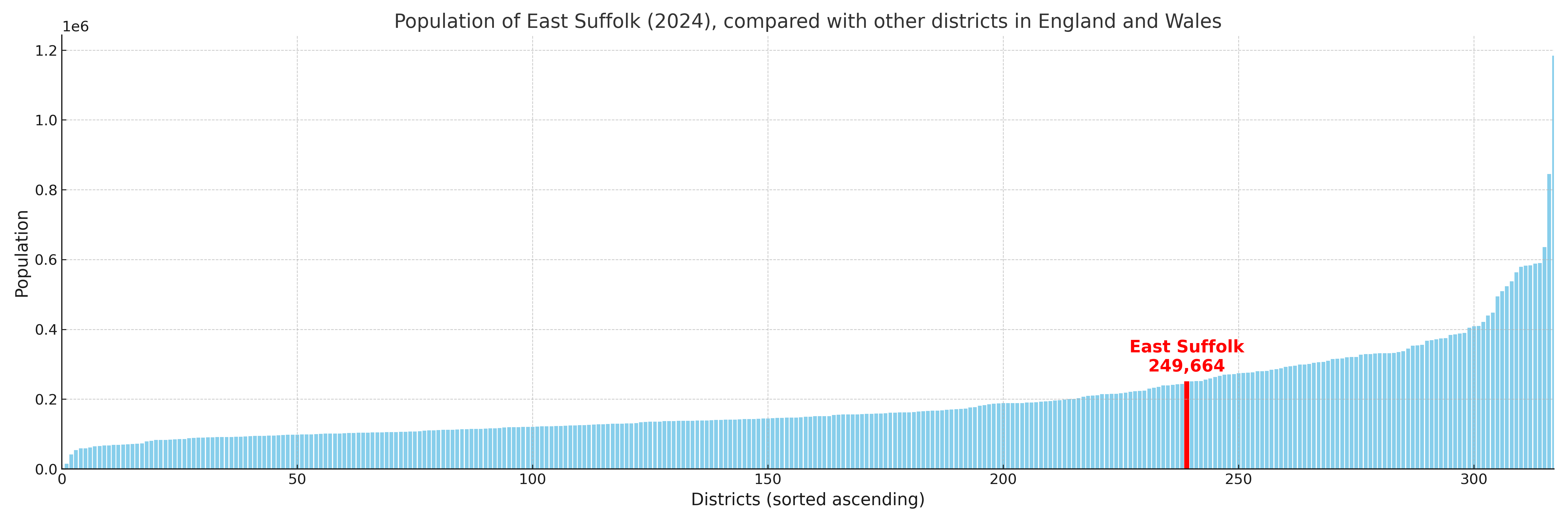
East Suffolk has a population of 249,664 (2024 mid-year estimate by ONS)
Population and Migration Trends in East Suffolk
This chart shows the population trend for East Suffolk from 2015 to 2024. It provides a quick overview of whether the local authority is growing, stable, or declining over time, and helps set context for the migration patterns shown below.
Population change is influenced by natural change (births minus deaths) and migration. The net migration chart below focuses on migration, separating internal migration (moves within the UK) from international migration (moves to and from abroad). Positive values indicate net inflows, while negative values indicate net outflows. The rate labels (per 1,000 residents) help compare migration intensity across years, even when the population size changes.
More local statistics and data for East Suffolk can be found on the ONS statistics for East Suffolk.
Latest news about East Suffolk
Use the search box, or suggested search phrases, below to find recent news, council updates, planning stories, housing developments, transport changes, public services news, local elections, community issues and other local developments related to East Suffolk. Results may include coverage from UK national, regional and local news websites, as well as official public-sector and local democracy sources.
- East Suffolk council
- East Suffolk planning
- East Suffolk local elections
- East Suffolk housing
- East Suffolk transport
- East Suffolk regeneration
- East Suffolk public services