Breckland
§ This page gives an overview of the Breckland local authority district, bringing together key facts, maps, and data to help you quickly understand the area. This is one of 361 LAD profiles on Baseview.
Overview ⁞ Breckland in Norfolk is a large rural district characterised by heathland, pine forests, and scattered market towns. The Thetford Forest, one of the largest man-made forests in the UK, dominates the landscape, offering outdoor recreation and nature habitats. Market towns like Thetford, Dereham, Swaffham, and Attleborough provide historic centres with medieval churches and traditional markets. The Brecks, with sandy soils, heath, and rare wildlife, give the district its unique geography, while wide open skies and agricultural fields shape its rural atmosphere.
Breckland Boundary Map
This map shows the official boundary of the Breckland local authority district, based on the latest geographic data published by the Office for National Statistics (ONS). It provides a clear view of the district’s extent and helps you understand how the area fits within the wider regional and national landscape.
Contains OS data © Crown copyright and database right 2025. Source: Office for National Statistics licensed under the Open Government Licence v3.0.
The administrative boundary of Breckland can also be viewed on OpenStreetMap: District Boundary of Breckland.
Key Facts about Breckland
What region is Breckland in? Breckland is in the East of England of England, a region within the UK.
What county is Breckland in? Breckland is located in the county of Norfolk.
Is Breckland a city? No, Breckland is not a city. (Note: the UK has 76 officially designated cities.)
Who governs Breckland? The local authority for this district is: Breckland District Council - responsible for district-level services. Since Norfolk is a two-tier area, county-level services are handled by: Norfolk County Council.
▶ Official website of Breckland District Council 🔗 breckland.gov.uk
Which police force covers Breckland? Policing in Breckland is provided by Norfolk Constabulary 🔗 norfolk.police.uk, which serves 7 local authority districts: Breckland ⁞ Broadland ⁞ Great Yarmouth ⁞ King's Lynn and West Norfolk ⁞ North Norfolk ⁞ Norwich ⁞ South Norfolk.
Breckland in International Geographies
In the International Territorial Levels (ITLs) hierarchy, Breckland is within an ITLs Level 3 area:
- (ITL 1) East of England
- (ITL 2) ⇒ Norfolk
- (ITL 3) ⇒⇒ Breckland and South Norfolk
The International Territorial Levels are used by OECD member countries for statistical purposes to classify administrative areas. We have this listable page for easy browsing of ITL names and codes: International Territorial Levels.
Constituencies in Breckland
Breckland is divided into 2 parliamentary constituencies, listed below in alphabetical order.
A constituency is a specific geographical area that elects one Member of Parliament (MP) to represent them in the House of Commons. The United Kingdom is divided into 650 parliamentary constituencies. We have this list page for easy browsing of all UK parliamentary constituencies: List of Constituencies.
Wards in Breckland
Breckland is divided into 27 wards, listed below in alphabetical order.
- All Saints & Wayland
- Ashill
- Attleborough Burgh & Haverscroft
- Attleborough Queens & Besthorpe
- Bedingfeld
- Dereham Neatherd
- Dereham Toftwood
- Dereham Withburga
- Forest
- Guiltcross
- Harling & Heathlands
- Hermitage
- Launditch
- Lincoln
- Mattishall
- Nar Valley
- Necton
- Saham Toney
- Shipdham-with-Scarning
- Swaffham
- The Buckenhams & Banham
- Thetford Boudica
- Thetford Burrell
- Thetford Castle
- Thetford Priory
- Upper Wensum
- Watton
In the UK, a ward is a subdivision of a local authority area, used mainly for electoral and statistical purposes. Defined by the ONS, wards represent the primary unit for local elections, each returning one or more councillors to the local council. Wards are also used as a key geography for presenting population and census data. We have this list page for easy browsing of all electoral wards: List of all Electoral Wards in the UK.
Parishes in Breckland
Breckland is fully parished: 113 civil parishes, listed A-Z below.
- Ashill
- Attleborough
- Banham
- Bawdeswell
- Beachamwell
- Beeston with Bittering
- Beetley
- Besthorpe
- Billingford
- Bintree
- Blo' Norton
- Bradenham
- Brettenham
- Bridgham
- Brisley
- Bylaugh
- Carbrooke
- Caston
- Cockley Cley
- Colkirk
- Cranwich
- Cranworth
- Croxton
- Dereham
- Didlington
- East Tuddenham
- Elsing
- Foulden
- Foxley
- Fransham
- Garboldisham
- Garvestone, Reymerston and Thuxton
- Gateley
- Gooderstone
- Great Cressingham
- Great Dunham
- Great Ellingham
- Gressenhall
- Griston
- Guist
- Hardingham
- Harling
- Hilborough
- Hockering
- Hockham
- Hoe and Worthing
- Holme Hale
- Horningtoft
- Ickburgh
- Kempstone
- Kenninghall
- Kilverstone
- Lexham
- Litcham
- Little Cressingham
- Little Dunham
- Little Ellingham
- Longham
- Lynford
- Lyng
- Mattishall
- Merton
- Mileham
- Mundford
- Narborough
- Narford
- Necton
- New Buckenham
- Newton by Castle Acre
- North Elmham
- North Lopham
- North Pickenham
- North Tuddenham
- Old Buckenham
- Ovington
- Oxborough
- Quidenham
- Riddlesworth
- Rocklands
- Roudham and Larling
- Rougham
- Saham Toney
- Scarning
- Scoulton
- Shipdham
- Shropham
- Snetterton
- South Acre
- South Lopham
- South Pickenham
- Sparham
- Sporle with Palgrave
- Stanfield
- Stanford
- Stow Bedon and Breckles
- Sturston
- Swaffham
- Swanton Morley
- Thetford
- Thompson
- Tittleshall
- Tottington
- Twyford
- Watton
- Weasenham All Saints
- Weasenham St. Peter
- Weeting-with-Broomhill
- Wellingham
- Wendling
- Whinburgh and Westfield
- Whissonsett
- Wretham
- Yaxham
A civil parish is the lowest tier of local government in England, used for villages, small towns, and suburbs. They have their own local authority, either a parish council or a parish meeting, which provides local services like managing parks, allotments, and streetlights, and represents the community's views to larger councils.
We have this list page for easy browsing of all parishes: List of Civil Parishes in England and Wales.
Post Towns in Breckland
Below is a list of post towns in Breckland, grouped by postcode area:
- IP ▸ Thetford (IP24 / IP25 / IP26)
- NR ▸ Attleborough (NR17) ⁞ Dereham (NR19 / NR20)
- PE ▸ Swaffham (PE37)
The UK postal hierarchy begins with broad postcode areas (such as “CB” or “M”), which are divided into smaller postcode districts (such as “CB8” or “M1”) to support accurate mail routing. Each postal address is anchored by a designated post town, the official locality name used in the UK postcode system, which operates independently from Local Authority Districts —the administrative boundaries used for council tax and local government services. Because they serve different purposes, a property’s postal address and its local authority district do not always align exactly.
Built-up Areas in Breckland
Breckland covers 60 built-up areas, listed below in alphabetical order.
- Ashill
- Attleborough
- Banham
- Bawdeswell
- Beachamwell
- Beeston (Breckland)
- Beetley
- Besthorpe
- Bradenham
- Brandon (West Suffolk) *
- Carbrooke
- Caston
- Clint Green
- Colkirk
- Dereham
- East Harling
- Eccles Road
- Foulden
- Foxley
- Garboldisham
- Garvestone
- Gooderstone
- Great Ellingham
- Great Hockham
- Gressenhall
- Griston
- Harling Road
- Hockering
- Ickburgh
- Kenninghall
- Letton Green
- Litcham
- Lyng
- Marham *
- Mattishall *
- Mileham
- Morley St Peter *
- Mundford
- Narborough *
- Necton
- North Elmham
- North Lopham
- North Pickenham
- Old Buckenham
- Rockland All Saints
- Saham Toney
- Shipdham
- Shropham
- South Lopham
- Sporle
- Swaffham
- Swanton Morley
- Thetford
- Thompson
- Watton
- Weeting
- Weston Green *
- Whissonsett
- Workhouse Common
- Yaxham
In the UK, a Built-up Area (BUA) is a continuous urban area of at least 20 hectares (0.2 km²), defined by the ONS as land where buildings are generally no more than 200 metres apart, such as towns, cities, or large villages. (Note: A BUA name marked with an asterisk (*) indicates that the area is situated partly in the district of Breckland.)
We have this list page for easy browsing of all built-up areas: List of all Built-up Areas in GB.
Railway Stations in Breckland
Breckland is served by a number of National Rail stations, providing rail connections to nearby towns, cities, and destinations across Great Britain. The railway stations listed below are located within the Breckland Local Authority District and are grouped by train operating company for clarity.
- Greater Anglia ▸ Thetford (IP24 1AH) ⁞ Attleborough (NR17 2AS) ⁞ Brandon (IP27 0BA) ⁞ Harling Road (NR16 2QP) ⁞ Eccles Road (NR16 2JG)
This is a district-level view only. For a complete list of all National Rail stations across Great Britain, see the UK National Rail Stations Directory.
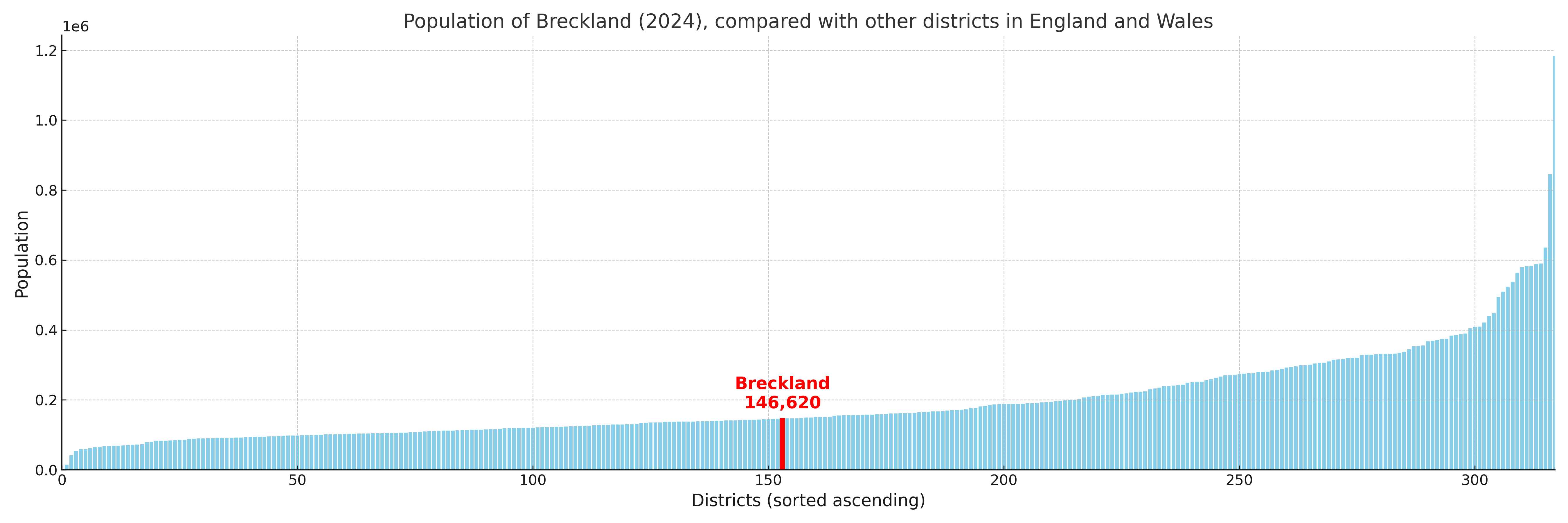
Breckland compared with other districts in the UK
This section shows how Breckland compares with other local authority districts in the UK, using a variety of measures and rankings.
Breckland has 27 electoral wards.

Breckland has a population of 146,620 (2024 mid-year estimate by ONS)
Population and Migration Trends in Breckland
This chart shows the population trend for Breckland from 2015 to 2024. It provides a quick overview of whether the local authority is growing, stable, or declining over time, and helps set context for the migration patterns shown below.
Population change is influenced by natural change (births minus deaths) and migration. The net migration chart below focuses on migration, separating internal migration (moves within the UK) from international migration (moves to and from abroad). Positive values indicate net inflows, while negative values indicate net outflows. The rate labels (per 1,000 residents) help compare migration intensity across years, even when the population size changes.
More local statistics and data for Breckland can be found on the ONS statistics for Breckland.
Latest news about Breckland
Use the search box, or suggested search phrases, below to find recent news, council updates, planning stories, housing developments, transport changes, public services news, local elections, community issues and other local developments related to Breckland. Results may include coverage from UK national, regional and local news websites, as well as official public-sector and local democracy sources.
- Breckland council
- Breckland planning
- Breckland local elections
- Breckland housing
- Breckland transport
- Breckland regeneration
- Breckland public services