Mid Suffolk
§ This page gives an overview of the Mid Suffolk local authority district, bringing together key facts, maps, and data to help you quickly understand the area. This is one of 361 LAD profiles on Baseview.
Overview ⁞ Mid Suffolk is a predominantly rural district filled with villages, farmland, and market towns. Stowmarket is the principal town, with the Museum of East Anglian Life and riverside parks, while Eye and Needham Market add historic interest with churches, castles, and traditional streets. The countryside is characterised by meadows, woodlands, and agricultural fields, dotted with windmills and timber-framed houses. Its landscape reflects a quintessential Suffolk rural setting.
Mid Suffolk Boundary Map
This map shows the official boundary of the Mid Suffolk local authority district, based on the latest geographic data published by the Office for National Statistics (ONS). It provides a clear view of the district’s extent and helps you understand how the area fits within the wider regional and national landscape.
Contains OS data © Crown copyright and database right 2025. Source: Office for National Statistics licensed under the Open Government Licence v3.0.
The administrative boundary of Mid Suffolk can also be viewed on OpenStreetMap: District Boundary of Mid Suffolk.
Key Facts about Mid Suffolk
What region is Mid Suffolk in? Mid Suffolk is in the East of England of England, a region within the UK.
What county is Mid Suffolk in? Mid Suffolk is located in the county of Suffolk.
Is Mid Suffolk a city? No, Mid Suffolk is not a city. (Note: the UK has 76 officially designated cities.)
Who governs Mid Suffolk? The local authority for this district is: Mid Suffolk District Council - responsible for district-level services. Since Suffolk is a two-tier area, county-level services are handled by: Suffolk County Council.
▶ Official website of Mid Suffolk District Council 🔗 midsuffolk.gov.uk
Which police force covers Mid Suffolk? Policing in Mid Suffolk is provided by Suffolk Constabulary 🔗 suffolk.police.uk, which serves 5 local authority districts: Babergh ⁞ East Suffolk ⁞ Ipswich ⁞ Mid Suffolk ⁞ West Suffolk.
Mid Suffolk in International Geographies
In the International Territorial Levels (ITLs) hierarchy, Mid Suffolk is within an ITLs Level 3 area:
- (ITL 1) East of England
- (ITL 2) ⇒ Suffolk
- (ITL 3) ⇒⇒ Babergh and Mid Suffolk
The International Territorial Levels are used by OECD member countries for statistical purposes to classify administrative areas. We have this listable page for easy browsing of ITL names and codes: International Territorial Levels.
Constituencies in Mid Suffolk
Mid Suffolk is divided into 3 parliamentary constituencies, listed below in alphabetical order.
A constituency is a specific geographical area that elects one Member of Parliament (MP) to represent them in the House of Commons. The United Kingdom is divided into 650 parliamentary constituencies. We have this list page for easy browsing of all UK parliamentary constituencies: List of Constituencies.
Wards in Mid Suffolk
Mid Suffolk is divided into 26 wards, listed below in alphabetical order.
- Bacton
- Battisford & Ringshall
- Blakenham
- Bramford
- Chilton
- Claydon & Barham
- Combs Ford
- Debenham
- Elmswell & Woolpit
- Eye
- Fressingfield
- Gislingham
- Haughley, Stowupland & Wetherden
- Hoxne & Worlingworth
- Mendlesham
- Needham Market
- Onehouse
- Palgrave
- Rattlesden
- Rickinghall
- St Peter's
- Stonham
- Stow Thorney
- Stradbroke & Laxfield
- Thurston
- Walsham-le-Willows
In the UK, a ward is a subdivision of a local authority area, used mainly for electoral and statistical purposes. Defined by the ONS, wards represent the primary unit for local elections, each returning one or more councillors to the local council. Wards are also used as a key geography for presenting population and census data. We have this list page for easy browsing of all electoral wards: List of all Electoral Wards in the UK.
Parishes in Mid Suffolk
Mid Suffolk is fully parished: 123 civil parishes, listed A-Z below.
- Akenham
- Ashbocking
- Ashfield cum Thorpe
- Aspall
- Athelington
- Bacton
- Badley
- Badwell Ash
- Barham
- Barking
- Battisford
- Baylham
- Bedfield
- Bedingfield
- Beyton
- Botesdale
- Braiseworth
- Bramford
- Brome and Oakley
- Brundish
- Burgate
- Buxhall
- Claydon
- Coddenham
- Combs
- Cotton
- Creeting St. Mary
- Creeting St. Peter or West Creeting
- Crowfield
- Darmsden
- Debenham
- Denham
- Drinkstone
- Earl Stonham
- Elmswell
- Eye
- Felsham
- Finningham
- Flowton
- Framsden
- Fressingfield
- Gedding
- Gipping
- Gislingham
- Gosbeck
- Great Ashfield
- Great Blakenham
- Great Bricett
- Great Finborough
- Harleston
- Haughley
- Helmingham
- Hemingstone
- Henley
- Hessett
- Hinderclay
- Horham
- Hoxne
- Hunston
- Kenton
- Langham
- Laxfield
- Little Blakenham
- Little Finborough
- Mellis
- Mendham
- Mendlesham
- Metfield
- Mickfield
- Monk Soham
- Needham Market
- Nettlestead
- Norton
- Occold
- Offton
- Old Newton with Dagworth
- Onehouse
- Palgrave
- Pettaugh
- Rattlesden
- Redgrave
- Redlingfield
- Rickinghall Inferior
- Rickinghall Superior
- Ringshall
- Rishangles
- Shelland
- Somersham
- Southolt
- Stoke Ash
- Stonham Aspal
- Stonham Parva
- Stowlangtoft
- Stowmarket
- Stowupland
- Stradbroke
- Stuston
- Syleham
- Tannington
- Thorndon
- Thornham Magna
- Thornham Parva
- Thrandeston
- Thurston
- Thwaite
- Tostock
- Walsham-le-Willows
- Wattisfield
- Westhorpe
- Wetherden
- Wetheringsett-cum-Brockford
- Weybread
- Whitton
- Wickham Skeith
- Wilby
- Willisham
- Wingfield
- Winston
- Woolpit
- Worlingworth
- Wortham
- Wyverstone
- Yaxley
A civil parish is the lowest tier of local government in England, used for villages, small towns, and suburbs. They have their own local authority, either a parish council or a parish meeting, which provides local services like managing parks, allotments, and streetlights, and represents the community's views to larger councils.
We have this list page for easy browsing of all parishes: List of Civil Parishes in England and Wales.
Post Towns in Mid Suffolk
Below is a list of post towns in Mid Suffolk, grouped by postcode area:
- IP ▸ Eye (IP21 / IP23) ⁞ Stowmarket (IP14)
The UK postal hierarchy begins with broad postcode areas (such as “CB” or “M”), which are divided into smaller postcode districts (such as “CB8” or “M1”) to support accurate mail routing. Each postal address is anchored by a designated post town, the official locality name used in the UK postcode system, which operates independently from Local Authority Districts —the administrative boundaries used for council tax and local government services. Because they serve different purposes, a property’s postal address and its local authority district do not always align exactly.
Built-up Areas in Mid Suffolk
Mid Suffolk covers 67 built-up areas, listed below in alphabetical order.
- Ashbocking *
- Bacton and Cotton
- Badwell Ash
- Barking
- Battisford Tye
- Bedfield
- Beyton
- Bramford
- Brome
- Burstallhill
- Claydon
- Coddenham
- Crowfield
- Debenham
- Diss *
- Drinkstone Green
- Elmswell
- Eye (Mid Suffolk)
- Felsham
- Finningham
- Fressingfield
- Gislingham
- Great Blakenham
- Great Bricett *
- Great Finborough
- Haughley
- Heckfield Green
- Henley
- Hessett
- Hinderclay
- Horham
- Ipswich *
- Laxfield
- Mellis
- Mendlesham
- Metfield
- Nedging Tye *
- Needham Market
- Norton (Mid Suffolk)
- Occold
- Old Newton
- Pakenham *
- Palgrave
- Rattlesden
- Redgrave
- Rickinghall and Botesdale
- Sharpstone Street
- Somersham (Mid Suffolk)
- Stonham Aspal
- Stowmarket
- Stowupland
- Stradbroke
- Thorndon
- Thurston *
- Tostock
- Upthorpe (West Suffolk) *
- Walsham le Willows
- Wattisfield
- Wetherden
- Wetheringsett
- Wickham Skeith
- Wingfield
- Woolpit
- Woolpit Heath
- Worlingworth
- Wortham
- Yaxley (Mid Suffolk)
In the UK, a Built-up Area (BUA) is a continuous urban area of at least 20 hectares (0.2 km²), defined by the ONS as land where buildings are generally no more than 200 metres apart, such as towns, cities, or large villages. (Note: A BUA name marked with an asterisk (*) indicates that the area is situated partly in the district of Mid Suffolk.)
We have this list page for easy browsing of all built-up areas: List of all Built-up Areas in GB.
Railway Stations in Mid Suffolk
Mid Suffolk is served by a number of National Rail stations, providing rail connections to nearby towns, cities, and destinations across Great Britain. The railway stations listed below are located within the Mid Suffolk Local Authority District and are grouped by train operating company for clarity.
- Greater Anglia ▸ Stowmarket (IP14 1RQ) ⁞ Needham Market (IP6 8AS) ⁞ Thurston (IP31 3QU) ⁞ Elmswell (IP30 9HA)
This is a district-level view only. For a complete list of all National Rail stations across Great Britain, see the UK National Rail Stations Directory.
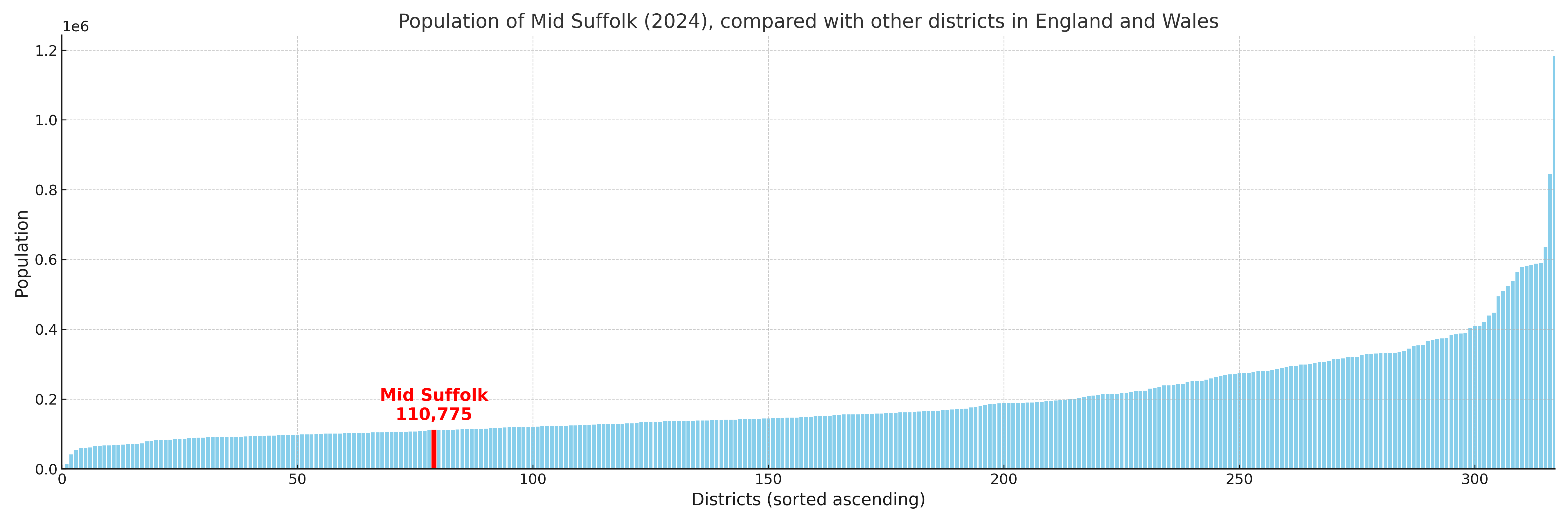
Mid Suffolk compared with other districts in the UK
This section shows how Mid Suffolk compares with other local authority districts in the UK, using a variety of measures and rankings.
Mid Suffolk has 26 electoral wards.

Mid Suffolk has a population of 110,775 (2024 mid-year estimate by ONS)
Population and Migration Trends in Mid Suffolk
This chart shows the population trend for Mid Suffolk from 2015 to 2024. It provides a quick overview of whether the local authority is growing, stable, or declining over time, and helps set context for the migration patterns shown below.
Population change is influenced by natural change (births minus deaths) and migration. The net migration chart below focuses on migration, separating internal migration (moves within the UK) from international migration (moves to and from abroad). Positive values indicate net inflows, while negative values indicate net outflows. The rate labels (per 1,000 residents) help compare migration intensity across years, even when the population size changes.
More local statistics and data for Mid Suffolk can be found on the ONS statistics for Mid Suffolk.
Latest news about Mid Suffolk
Use the search box, or suggested search phrases, below to find recent news, council updates, planning stories, housing developments, transport changes, public services news, local elections, community issues and other local developments related to Mid Suffolk. Results may include coverage from UK national, regional and local news websites, as well as official public-sector and local democracy sources.
- Mid Suffolk council
- Mid Suffolk planning
- Mid Suffolk local elections
- Mid Suffolk housing
- Mid Suffolk transport
- Mid Suffolk regeneration
- Mid Suffolk public services