North Norfolk
§ This page gives an overview of the North Norfolk local authority district, bringing together key facts, maps, and data to help you quickly understand the area. This is one of 361 LAD profiles on Baseview.
Overview ⁞ North Norfolk is renowned for its unspoiled coastline, with sandy beaches, saltmarshes, and nature reserves stretching from Hunstanton to Happisburgh. Towns like Cromer, with its pier and crab fishing, and Sheringham, with its heritage railway, are popular seaside destinations. Inland, Holt and North Walsham provide market town character, while villages with flint cottages and medieval churches dot the countryside. The Norfolk Coast Area of Outstanding Natural Beauty highlights the district’s wildlife habitats and scenic beauty.
North Norfolk Boundary Map
This map shows the official boundary of the North Norfolk local authority district, based on the latest geographic data published by the Office for National Statistics (ONS). It provides a clear view of the district’s extent and helps you understand how the area fits within the wider regional and national landscape.
Contains OS data © Crown copyright and database right 2025. Source: Office for National Statistics licensed under the Open Government Licence v3.0.
The administrative boundary of North Norfolk can also be viewed on OpenStreetMap: District Boundary of North Norfolk.
Key Facts about North Norfolk
What region is North Norfolk in? North Norfolk is in the East of England of England, a region within the UK.
What county is North Norfolk in? North Norfolk is located in the county of Norfolk.
Is North Norfolk a city? No, North Norfolk is not a city. (Note: the UK has 76 officially designated cities.)
Who governs North Norfolk? The local authority for this district is: North Norfolk District Council - responsible for district-level services. Since Norfolk is a two-tier area, county-level services are handled by: Norfolk County Council.
▶ Official website of North Norfolk District Council 🔗 north-norfolk.gov.uk
Which police force covers North Norfolk? Policing in North Norfolk is provided by Norfolk Constabulary 🔗 norfolk.police.uk, which serves 7 local authority districts: Breckland ⁞ Broadland ⁞ Great Yarmouth ⁞ King's Lynn and West Norfolk ⁞ North Norfolk ⁞ Norwich ⁞ South Norfolk.
Constituencies in North Norfolk
North Norfolk is divided into 2 parliamentary constituencies, listed below in alphabetical order.
A constituency is a specific geographical area that elects one Member of Parliament (MP) to represent them in the House of Commons. The United Kingdom is divided into 650 parliamentary constituencies. We have this list page for easy browsing of all UK parliamentary constituencies: List of Constituencies.
Wards in North Norfolk
North Norfolk is divided into 32 wards, listed below in alphabetical order.
- Bacton
- Beeston Regis & The Runtons
- Briston
- Coastal
- Cromer Town
- Erpingham
- Gresham
- Happisburgh
- Hickling
- Holt
- Hoveton & Tunstead
- Lancaster North
- Lancaster South
- Mundesley
- North Walsham East
- North Walsham Market Cross
- North Walsham West
- Poppyland
- Priory
- Roughton
- Sheringham North
- Sheringham South
- St Benet's
- Stalham
- Stibbard
- Stody
- Suffield Park
- The Raynhams
- Trunch
- Walsingham
- Wells with Holkham
- Worstead
In the UK, a ward is a subdivision of a local authority area, used mainly for electoral and statistical purposes. Defined by the ONS, wards represent the primary unit for local elections, each returning one or more councillors to the local council. Wards are also used as a key geography for presenting population and census data. We have this list page for easy browsing of all electoral wards: List of all Electoral Wards in the UK.
Parishes in North Norfolk
North Norfolk is fully parished: 122 civil parishes, listed A-Z below.
- Alby with Thwaite
- Aldborough & Thurgarton
- Antingham
- Ashmanhaugh
- Aylmerton
- Baconsthorpe
- Bacton
- Barsham
- Barton Turf
- Beeston Regis
- Binham
- Blakeney
- Bodham
- Briningham
- Brinton
- Briston
- Brumstead
- Catfield
- Cley Next The Sea
- Colby
- Corpusty and Saxthorpe
- Cromer
- Dilham
- Dunton
- East Beckham
- East Ruston
- Edgefield
- Erpingham
- Fakenham
- Felbrigg
- Felmingham
- Field Dalling
- Fulmodeston
- Gimingham
- Great Snoring
- Gresham
- Gunthorpe
- Hanworth
- Happisburgh
- Helhoughton
- Hempstead
- Hempton
- Hickling
- High Kelling
- Hindolveston
- Hindringham
- Holkham
- Holt
- Honing
- Horning
- Horsey
- Hoveton
- Ingham
- Ingworth
- Itteringham
- Kelling
- Kettlestone
- Knapton
- Langham
- Lessingham
- Letheringsett with Glandford
- Little Barningham
- Little Snoring
- Ludham
- Matlask
- Melton Constable
- Morston
- Mundesley
- Neatishead
- North Walsham
- Northrepps
- Overstrand
- Paston
- Plumstead
- Potter Heigham
- Pudding Norton
- Raynham
- Roughton
- Runton
- Ryburgh
- Salthouse
- Scottow
- Sculthorpe
- Sea Palling
- Sheringham
- Sidestrand
- Skeyton
- Sloley
- Smallburgh
- Southrepps
- Stalham
- Stibbard
- Stiffkey
- Stody
- Suffield
- Sustead
- Sutton
- Swafield
- Swanton Abbott
- Swanton Novers
- Tattersett
- Thornage
- Thorpe Market
- Thurning
- Thursford
- Trimingham
- Trunch
- Tunstead
- Upper Sheringham
- Walcott
- Walsingham
- Warham
- Wells-next-the-Sea
- West Beckham
- Westwick
- Weybourne
- Wickmere
- Wighton
- Witton
- Wiveton
- Wood Norton
- Worstead
A civil parish is the lowest tier of local government in England, used for villages, small towns, and suburbs. They have their own local authority, either a parish council or a parish meeting, which provides local services like managing parks, allotments, and streetlights, and represents the community's views to larger councils.
We have this list page for easy browsing of all parishes: List of Civil Parishes in England and Wales.
Post Towns in North Norfolk
Below is a list of post towns in North Norfolk, grouped by postcode area:
- NR ▸ Cromer (NR27) ⁞ Fakenham (NR21) ⁞ Holt (NR25) ⁞ Melton Constable (NR24) ⁞ North Walsham (NR28) ⁞ Sheringham (NR26) ⁞ Walsingham (NR22) ⁞ Wells-next-the-Sea (NR23)
The UK postal hierarchy begins with broad postcode areas (such as “CB” or “M”), which are divided into smaller postcode districts (such as “CB8” or “M1”) to support accurate mail routing. Each postal address is anchored by a designated post town, the official locality name used in the UK postcode system, which operates independently from Local Authority Districts —the administrative boundaries used for council tax and local government services. Because they serve different purposes, a property’s postal address and its local authority district do not always align exactly.
Built-up Areas in North Norfolk
North Norfolk covers 58 built-up areas, listed below in alphabetical order.
- Aldborough
- Aylmerton
- Bacton
- Badersfield *
- Binham
- Blakeney (North Norfolk)
- Briston
- Butcher's Common
- Catfield
- Cley next the Sea
- Corpusty
- Cromer
- East Runton
- Eccles on Sea
- Edgefield
- Erpingham
- Fakenham
- Great Ryburgh
- Gresham
- Happisburgh
- Hempton
- Hickling (North Norfolk)
- High Kelling
- Hindolveston
- Holt (North Norfolk)
- Horning *
- Hoveton and Wroxham *
- Kettlestone
- Knapton
- Langham (North Norfolk)
- Little Walsingham
- Ludham
- Melton Constable
- Mundesley
- Neatishead
- North Walsham
- Overstrand
- Paston
- Potter Heigham
- Roughton
- Salthouse
- Sculthorpe
- Sea Palling
- Sheringham
- Southrepps
- Stalham
- Stibbard
- Sutton (North Norfolk)
- Thursford Green
- Trimingham
- Trunch
- Walcott (North Norfolk)
- Wells-next-the-Sea
- West Raynham
- West Runton and Beeston Regis
- Weybourne (North Norfolk)
- Wicken Green Village *
- Wiveton
In the UK, a Built-up Area (BUA) is a continuous urban area of at least 20 hectares (0.2 km²), defined by the ONS as land where buildings are generally no more than 200 metres apart, such as towns, cities, or large villages. (Note: A BUA name marked with an asterisk (*) indicates that the area is situated partly in the district of North Norfolk.)
We have this list page for easy browsing of all built-up areas: List of all Built-up Areas in GB.
Railway Stations in North Norfolk
North Norfolk is served by a number of National Rail stations, providing rail connections to nearby towns, cities, and destinations across Great Britain. The railway stations listed below are located within the North Norfolk Local Authority District and are grouped by train operating company for clarity.
- Greater Anglia ▸ Sheringham (NR26 8RA) ⁞ Cromer (NR27 9EB) ⁞ North Walsham (NR28 0DZ) ⁞ Hoveton and Wroxham (NR12 8UR) ⁞ Gunton (NR11 8UD) ⁞ West Runton (NR27 9QD) ⁞ Worstead (NR28 9RX) ⁞ Roughton Road (NR27 9LN)
This is a district-level view only. For a complete list of all National Rail stations across Great Britain, see the UK National Rail Stations Directory.
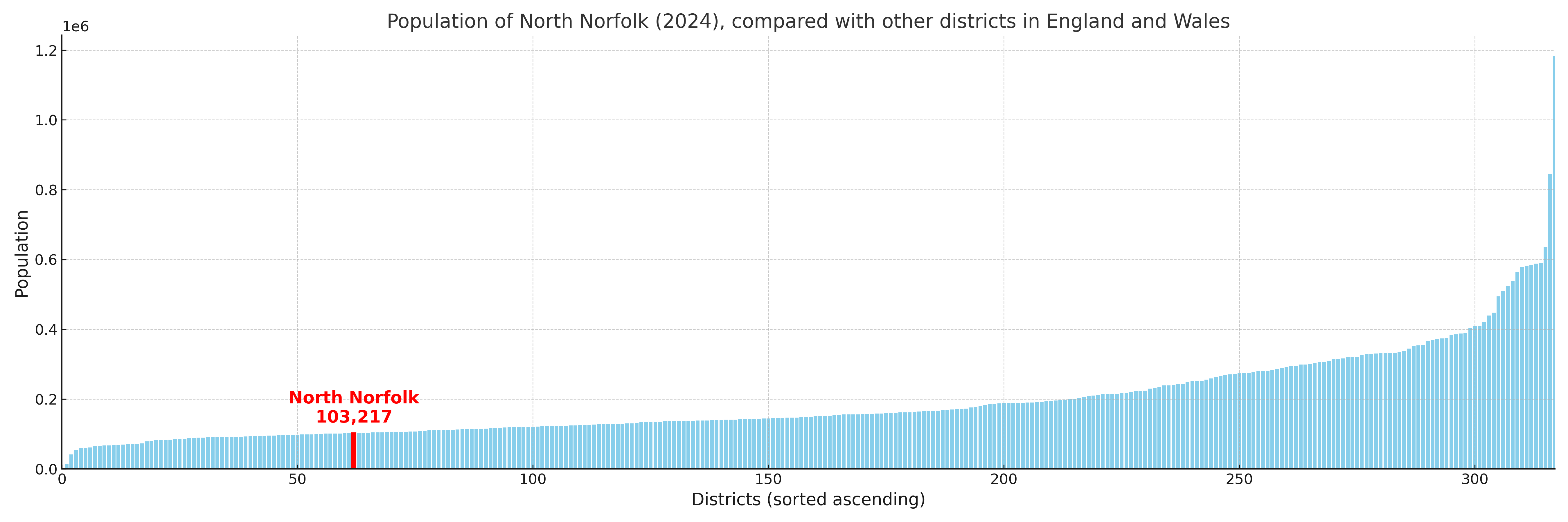
North Norfolk compared with other districts in the UK
This section shows how North Norfolk compares with other local authority districts in the UK, using a variety of measures and rankings.
North Norfolk has 32 electoral wards.

North Norfolk has a population of 103,217 (2024 mid-year estimate by ONS)
Population and Migration Trends in North Norfolk
This chart shows the population trend for North Norfolk from 2015 to 2024. It provides a quick overview of whether the local authority is growing, stable, or declining over time, and helps set context for the migration patterns shown below.
Population change is influenced by natural change (births minus deaths) and migration. The net migration chart below focuses on migration, separating internal migration (moves within the UK) from international migration (moves to and from abroad). Positive values indicate net inflows, while negative values indicate net outflows. The rate labels (per 1,000 residents) help compare migration intensity across years, even when the population size changes.
More local statistics and data for North Norfolk can be found on the ONS statistics for North Norfolk.
Latest news about North Norfolk
Use the search box, or suggested search phrases, below to find recent news, council updates, planning stories, housing developments, transport changes, public services news, local elections, community issues and other local developments related to North Norfolk. Results may include coverage from UK national, regional and local news websites, as well as official public-sector and local democracy sources.
- North Norfolk council
- North Norfolk planning
- North Norfolk local elections
- North Norfolk housing
- North Norfolk transport
- North Norfolk regeneration
- North Norfolk public services