Braintree
§ This page gives an overview of the Braintree local authority district, bringing together key facts, maps, and data to help you quickly understand the area. This is one of 361 LAD profiles on Baseview.
Overview ⁞ Braintree district in north Essex combines thriving towns, countryside, and historic landmarks. The town of Braintree itself is known for its shopping outlets, museums, and textile heritage, while Witham and Halstead offer bustling high streets, parks, and historic churches. The surrounding countryside includes scenic villages such as Coggeshall, with its medieval timber-framed buildings and abbey, and Castle Hedingham, home to the impressive Norman Hedingham Castle. The River Blackwater winds through parts of the district, and Dedham Vale, an Area of Outstanding Natural Beauty nearby, enhances its rural charm. The district is a mix of vibrant communities, farmland, and historic attractions.
Braintree Boundary Map
This map shows the official boundary of the Braintree local authority district, based on the latest geographic data published by the Office for National Statistics (ONS). It provides a clear view of the district’s extent and helps you understand how the area fits within the wider regional and national landscape.
Contains OS data © Crown copyright and database right 2025. Source: Office for National Statistics licensed under the Open Government Licence v3.0.
The administrative boundary of Braintree can also be viewed on OpenStreetMap: District Boundary of Braintree.
Key Facts about Braintree
What region is Braintree in? Braintree is in the East of England of England, a region within the UK.
What county is Braintree in? Braintree is located in the county of Essex.
Is Braintree a city? No, Braintree is not a city. (Note: the UK has 76 officially designated cities.)
Who governs Braintree? The local authority for this district is: Braintree District Council - responsible for district-level services. Since Essex is a two-tier area, county-level services are handled by: Essex County Council.
▶ Official website of Braintree District Council 🔗 braintree.gov.uk
Which police force covers Braintree? Policing in Braintree is provided by Essex Police 🔗 essex.police.uk, which serves 14 local authority districts: Basildon ⁞ Braintree ⁞ Brentwood ⁞ Castle Point ⁞ Chelmsford ⁞ Colchester ⁞ Epping Forest ⁞ Harlow ⁞ Maldon ⁞ Rochford ⁞ Southend-on-Sea ⁞ Tendring ⁞ Thurrock ⁞ Uttlesford.
Constituencies in Braintree
Braintree is divided into 2 parliamentary constituencies, listed below in alphabetical order.
A constituency is a specific geographical area that elects one Member of Parliament (MP) to represent them in the House of Commons. The United Kingdom is divided into 650 parliamentary constituencies. We have this list page for easy browsing of all UK parliamentary constituencies: List of Constituencies.
Wards in Braintree
Braintree is divided into 26 wards, listed below in alphabetical order.
- Bocking Blackwater
- Bocking North
- Bocking South
- Braintree Central & Beckers Green
- Braintree South
- Braintree West
- Bumpstead
- Coggeshall
- Gosfield & Greenstead Green
- Great Notley & Black Notley
- Halstead St Andrew's
- Halstead Trinity
- Hatfield Peverel & Terling
- Hedingham
- Kelvedon & Feering
- Rayne
- Silver End & Cressing
- Stour Valley North
- Stour Valley South
- The Colnes
- Three Fields
- Witham Central
- Witham North
- Witham South
- Witham West
- Yeldham
In the UK, a ward is a subdivision of a local authority area, used mainly for electoral and statistical purposes. Defined by the ONS, wards represent the primary unit for local elections, each returning one or more councillors to the local council. Wards are also used as a key geography for presenting population and census data. We have this list page for easy browsing of all electoral wards: List of all Electoral Wards in the UK.
Parishes in Braintree
Braintree is part-parished: 63 civil parishes (listed A-Z below) alongside 2 unparished areas.
- Alphamstone
- Ashen
- Belchamp Otten
- Belchamp St. Paul
- Belchamp Walter
- Birdbrook
- Black Notley
- Borley
- Bradwell
- Bulmer
- Bures Hamlet
- Castle Hedingham
- Coggeshall
- Colne Engaine
- Cressing
- Earls Colne
- Fairstead
- Faulkbourne
- Feering
- Finchingfield
- Foxearth
- Gestingthorpe
- Gosfield
- Great Bardfield
- Great Henny
- Great Maplestead
- Great Notley
- Great Yeldham
- Greenstead Green and Halstead Rural
- Halstead
- Hatfield Peverel
- Helions Bumpstead
- Kelvedon
- Lamarsh
- Liston
- Little Henny
- Little Maplestead
- Little Yeldham
- Middleton
- Ovington
- Panfield
- Pebmarsh
- Pentlow
- Rayne
- Ridgewell
- Rivenhall
- Shalford
- Sible Hedingham
- Silver End
- Stambourne
- Steeple Bumpstead
- Stisted
- Sturmer
- Terling
- The Salings
- Tilbury Juxta Clare
- Toppesfield
- Twinstead
- Wethersfield
- White Colne
- White Notley
- Wickham St. Paul
- Witham
A civil parish is the lowest tier of local government in England, used for villages, small towns, and suburbs. They have their own local authority, either a parish council or a parish meeting, which provides local services like managing parks, allotments, and streetlights, and represents the community's views to larger councils.
We have this list page for easy browsing of all parishes: List of Civil Parishes in England and Wales.
Post Towns in Braintree
Below is a list of post towns in Braintree, grouped by postcode area:
- CM ▸ Braintree (CM7 / CM77) ⁞ Dunmow (CM6 / CM7) ⁞ Witham (CM8)
- CO ▸ Halstead (CO9)
The UK postal hierarchy begins with broad postcode areas (such as “CB” or “M”), which are divided into smaller postcode districts (such as “CB8” or “M1”) to support accurate mail routing. Each postal address is anchored by a designated post town, the official locality name used in the UK postcode system, which operates independently from Local Authority Districts —the administrative boundaries used for council tax and local government services. Because they serve different purposes, a property’s postal address and its local authority district do not always align exactly.
Built-up Areas in Braintree
Braintree covers 42 built-up areas, listed below in alphabetical order.
- Black Notley
- Bradwell (Braintree)
- Braintree
- Bures *
- Castle Hedingham
- Cavendish *
- Clare *
- Coggeshall
- Colne Engaine
- Earls Colne
- Finchingfield
- Gosfield
- Great Bardfield
- Great Notley
- Great Yeldham
- Halstead (Braintree)
- Hatfield Peverel
- Haverhill *
- Helions Bumpstead
- High Garrett
- Kelvedon and Feering
- Lamarsh
- Long Melford *
- Nounsley
- Panfield
- Pebmarsh
- Rayne *
- Ridgewell
- School Green
- Shalford (Braintree)
- Sible Hedingham
- Silver End
- Steeple Bumpstead
- Sturmer
- Sudbury *
- Toppesfield
- Tye Green (Braintree)
- Wethersfield
- White Colne
- Wickham St Paul
- Witham
- Young's End *
In the UK, a Built-up Area (BUA) is a continuous urban area of at least 20 hectares (0.2 km²), defined by the ONS as land where buildings are generally no more than 200 metres apart, such as towns, cities, or large villages. (Note: A BUA name marked with an asterisk (*) indicates that the area is situated partly in the district of Braintree.)
We have this list page for easy browsing of all built-up areas: List of all Built-up Areas in GB.
Railway Stations in Braintree
Braintree is served by a number of National Rail stations, providing rail connections to nearby towns, cities, and destinations across Great Britain. The railway stations listed below are located within the Braintree Local Authority District and are grouped by train operating company for clarity.
- Greater Anglia ▸ Witham (CM8 2BS) ⁞ Braintree (CM7 3QL) ⁞ Kelvedon (CO5 9NP) ⁞ Hatfield Peverel (CM3 2DX) ⁞ Braintree Freeport (CM77 8YH) ⁞ Bures (CO8 5HS) ⁞ Cressing (Essex) (CM77 8NT) ⁞ White Notley (CM8 1RP)
This is a district-level view only. For a complete list of all National Rail stations across Great Britain, see the UK National Rail Stations Directory.
Braintree compared with other districts in the UK
This section shows how Braintree compares with other local authority districts in the UK, using a variety of measures and rankings.
Braintree has 26 electoral wards.

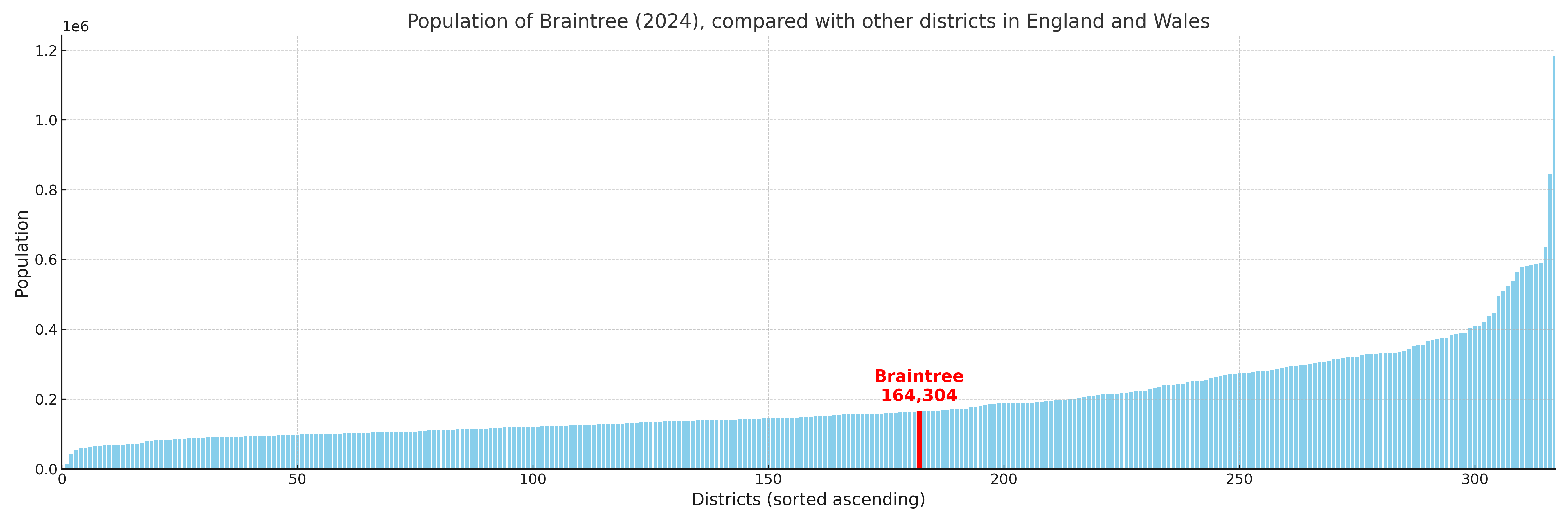
Braintree has a population of 164,304 (2024 mid-year estimate by ONS)
Population and Migration Trends in Braintree
This chart shows the population trend for Braintree from 2015 to 2024. It provides a quick overview of whether the local authority is growing, stable, or declining over time, and helps set context for the migration patterns shown below.
Population change is influenced by natural change (births minus deaths) and migration. The net migration chart below focuses on migration, separating internal migration (moves within the UK) from international migration (moves to and from abroad). Positive values indicate net inflows, while negative values indicate net outflows. The rate labels (per 1,000 residents) help compare migration intensity across years, even when the population size changes.
More local statistics and data for Braintree can be found on the ONS statistics for Braintree.
Latest news about Braintree
Use the search box, or suggested search phrases, below to find recent news, council updates, planning stories, housing developments, transport changes, public services news, local elections, community issues and other local developments related to Braintree. Results may include coverage from UK national, regional and local news websites, as well as official public-sector and local democracy sources.
- Braintree council
- Braintree planning
- Braintree local elections
- Braintree housing
- Braintree transport
- Braintree regeneration
- Braintree public services