Central Bedfordshire
§ This page gives an overview of the Central Bedfordshire local authority district, bringing together key facts, maps, and data to help you quickly understand the area. This is one of 361 LAD profiles on Baseview.
Overview ⁞ Central Bedfordshire covers a large area of countryside, market towns, and commuter settlements. Dunstable and Leighton Buzzard are the main towns, with attractions such as Whipsnade Zoo and the Grand Union Canal. The Chiltern Hills AONB provides scenic landscapes, while Ampthill, Biggleswade, and Flitwick add historic market town character. The district is defined by its rolling countryside, chalk hills, and wide mix of rural and suburban communities.
Central Bedfordshire Boundary Map
This map shows the official boundary of the Central Bedfordshire local authority district, based on the latest geographic data published by the Office for National Statistics (ONS). It provides a clear view of the district’s extent and helps you understand how the area fits within the wider regional and national landscape.
Contains OS data © Crown copyright and database right 2025. Source: Office for National Statistics licensed under the Open Government Licence v3.0.
The administrative boundary of Central Bedfordshire can also be viewed on OpenStreetMap: District Boundary of Central Bedfordshire.
Key Facts about Central Bedfordshire
What region is Central Bedfordshire in? Central Bedfordshire is in the East of England of England, a region within the UK.
What county is Central Bedfordshire in? Central Bedfordshire is in the county of Bedfordshire.
Is Central Bedfordshire a city? No, Central Bedfordshire is not a city. (Note: the UK has 76 officially designated cities.)
Who governs Central Bedfordshire? The local government for this district is: Central Bedfordshire Council (Unitary Authority).
▶ Official website of Central Bedfordshire Council 🔗 centralbedfordshire.gov.uk
Which police force covers Central Bedfordshire? Policing in Central Bedfordshire is provided by Bedfordshire Police 🔗 beds.police.uk, which serves 3 local authority districts: Bedford ⁞ Central Bedfordshire ⁞ Luton.
Central Bedfordshire in International Geographies
In the International Territorial Levels (ITLs) hierarchy, Central Bedfordshire is an ITLs Level 3 area:
- (ITL 1) East of England
- (ITL 2) ⇒ Bedfordshire and Hertfordshire
- (ITL 3) ⇒⇒ Central Bedfordshire
The International Territorial Levels are used by OECD member countries for statistical purposes to classify administrative areas. We have this listable page for easy browsing of ITL names and codes: International Territorial Levels.
Constituencies in Central Bedfordshire
Central Bedfordshire is divided into 5 parliamentary constituencies, listed below in alphabetical order.
- Dunstable and Leighton Buzzard
- Hitchin
- Luton South and South Bedfordshire
- Mid Bedfordshire
- North Bedfordshire
A constituency is a specific geographical area that elects one Member of Parliament (MP) to represent them in the House of Commons. The United Kingdom is divided into 650 parliamentary constituencies. We have this list page for easy browsing of all UK parliamentary constituencies: List of Constituencies.
Wards in Central Bedfordshire
Central Bedfordshire is divided into 31 wards, listed below in alphabetical order.
- Ampthill
- Arlesey & Fairfield
- Aspley & Woburn
- Barton-le-Clay & Silsoe
- Biggleswade East
- Biggleswade West
- Caddington
- Clifton, Henlow & Langford
- Cranfield & Marston Moretaine
- Dunstable Central
- Dunstable East
- Dunstable North
- Dunstable South
- Dunstable West
- Eaton Bray
- Flitwick
- Heath & Reach
- Houghton Conquest & Haynes
- Houghton Regis East
- Houghton Regis West
- Leighton-Linslade North
- Leighton-Linslade South
- Leighton-Linslade West
- Meppershall & Shillington
- Northill
- Potton
- Sandy
- Shefford
- Stotfold
- Toddington
- Westoning, Flitton & Greenfield
In the UK, a ward is a subdivision of a local authority area, used mainly for electoral and statistical purposes. Defined by the ONS, wards represent the primary unit for local elections, each returning one or more councillors to the local council. Wards are also used as a key geography for presenting population and census data. We have this list page for easy browsing of all electoral wards: List of all Electoral Wards in the UK.
Parishes in Central Bedfordshire
Central Bedfordshire is fully parished: 79 civil parishes, listed A-Z below.
- Ampthill
- Arlesey
- Aspley Guise
- Aspley Heath
- Astwick
- Barton-le-Clay
- Battlesden
- Biggleswade
- Billington
- Blunham
- Brogborough
- Caddington
- Campton and Chicksands
- Chalgrave
- Chalton
- Clifton
- Clophill
- Cranfield
- Dunstable
- Dunton
- Eaton Bray
- Edworth
- Eggington
- Eversholt
- Everton
- Eyeworth
- Fairfield
- Flitton and Greenfield
- Flitwick
- Gravenhurst
- Harlington
- Haynes
- Heath and Reach
- Henlow
- Hockliffe
- Houghton Conquest
- Houghton Regis
- Hulcote and Salford
- Husborne Crawley
- Hyde
- Kensworth
- Langford
- Leighton-Linslade
- Lidlington
- Marston Moreteyne
- Maulden
- Meppershall
- Millbrook
- Milton Bryan
- Moggerhanger
- Northill
- Old Warden
- Potsgrove
- Potton
- Pulloxhill
- Ridgmont
- Sandy
- Shefford
- Shillington
- Silsoe
- Slip End
- Southill
- Stanbridge
- Steppingley
- Stondon
- Stotfold
- Streatley
- Studham
- Sundon
- Sutton
- Tempsford
- Tilsworth
- Tingrith
- Toddington
- Totternhoe
- Westoning
- Whipsnade
- Woburn
- Wrestlingworth and Cockayne Hatley
A civil parish is the lowest tier of local government in England, used for villages, small towns, and suburbs. They have their own local authority, either a parish council or a parish meeting, which provides local services like managing parks, allotments, and streetlights, and represents the community's views to larger councils.
We have this list page for easy browsing of all parishes: List of Civil Parishes in England and Wales.
Post Towns in Central Bedfordshire
Below is a list of post towns in Central Bedfordshire, grouped by postcode area:
- LU ▸ Dunstable (LU5 / LU6) ⁞ Leighton Buzzard (LU7)
- SG ▸ Arlesey (SG15) ⁞ Biggleswade (SG18) ⁞ Henlow (SG16) ⁞ Sandy (SG19) ⁞ Shefford (SG17)
The UK postal hierarchy begins with broad postcode areas (such as “CB” or “M”), which are divided into smaller postcode districts (such as “CB8” or “M1”) to support accurate mail routing. Each postal address is anchored by a designated post town, the official locality name used in the UK postcode system, which operates independently from Local Authority Districts —the administrative boundaries used for council tax and local government services. Because they serve different purposes, a property’s postal address and its local authority district do not always align exactly.
Built-up Areas in Central Bedfordshire
Central Bedfordshire covers 76 built-up areas, listed below in alphabetical order.
- Ampthill
- Apsley End *
- Arlesey
- Aspley Guise *
- Barton-le-Clay
- Beeston (Central Bedfordshire)
- Biggleswade
- Billington (Central Bedfordshire)
- Blunham
- Brogborough
- Broom (Central Bedfordshire)
- Caddington
- Campton
- Chalton
- Chicksands
- Clifton (Central Bedfordshire)
- Clophill
- Cranfield
- Dunstable
- Dunton
- Eaton Bray and Edlesborough *
- Flitton
- Flitwick
- Great Barford *
- Greenfield (Central Bedfordshire)
- Harlington
- Harpenden *
- Haynes *
- Heath and Reach
- Henlow
- Hockliffe
- Holwell (North Hertfordshire) *
- Holywell (Central Bedfordshire)
- Houghton Conquest
- Houghton Regis *
- Ickwell
- Kensworth
- Langford (Central Bedfordshire)
- Leighton Buzzard *
- Letchworth *
- Lidlington
- Lower Stondon *
- Luton *
- Marston Moretaine
- Maulden
- Meppershall
- Milton Keynes *
- Moggerhanger
- Northill
- Oldhill Wood
- Potton
- Pulloxhill
- Ridgmont
- Sandy
- Shefford
- Shillington
- Silsoe
- Slip End *
- Southill
- Stanbridge
- Stewartby *
- Stotfold *
- Streatley (Central Bedfordshire)
- Tebworth
- Tempsford
- Tilsworth
- Toddington
- Totternhoe
- Upper Caldecote
- Upper Gravenhurst
- Westoning
- Wixams *
- Woburn
- Woburn Sands *
- Wootton (Bedford) *
- Wrestlingworth
In the UK, a Built-up Area (BUA) is a continuous urban area of at least 20 hectares (0.2 km²), defined by the ONS as land where buildings are generally no more than 200 metres apart, such as towns, cities, or large villages. (Note: A BUA name marked with an asterisk (*) indicates that the area is situated partly in the district of Central Bedfordshire.)
We have this list page for easy browsing of all built-up areas: List of all Built-up Areas in GB.
Railway Stations in Central Bedfordshire
Central Bedfordshire is served by a number of National Rail stations, providing rail connections to nearby towns, cities, and destinations across Great Britain. The railway stations listed below are located within the Central Bedfordshire Local Authority District and are grouped by train operating company for clarity.
- Govia Thameslink Railway (Great Northern) ▸ Biggleswade (SG18 8AL) ⁞ Arlesey (SG15 6XA) ⁞ Sandy (SG19 1AW)
- Govia Thameslink Railway (Thameslink) ▸ Flitwick (MK45 1AJ) ⁞ Harlington (Bedfordshire) (LU5 6LD)
- West Midlands Trains (London Northwestern Railway) ▸ Leighton Buzzard (LU7 2LY) ⁞ Ridgmont (MK43 0XP) ⁞ Lidlington (MK43 0SA) ⁞ Millbrook (Bedfordshire) (MK45 2JH)
This is a district-level view only. For a complete list of all National Rail stations across Great Britain, see the UK National Rail Stations Directory.
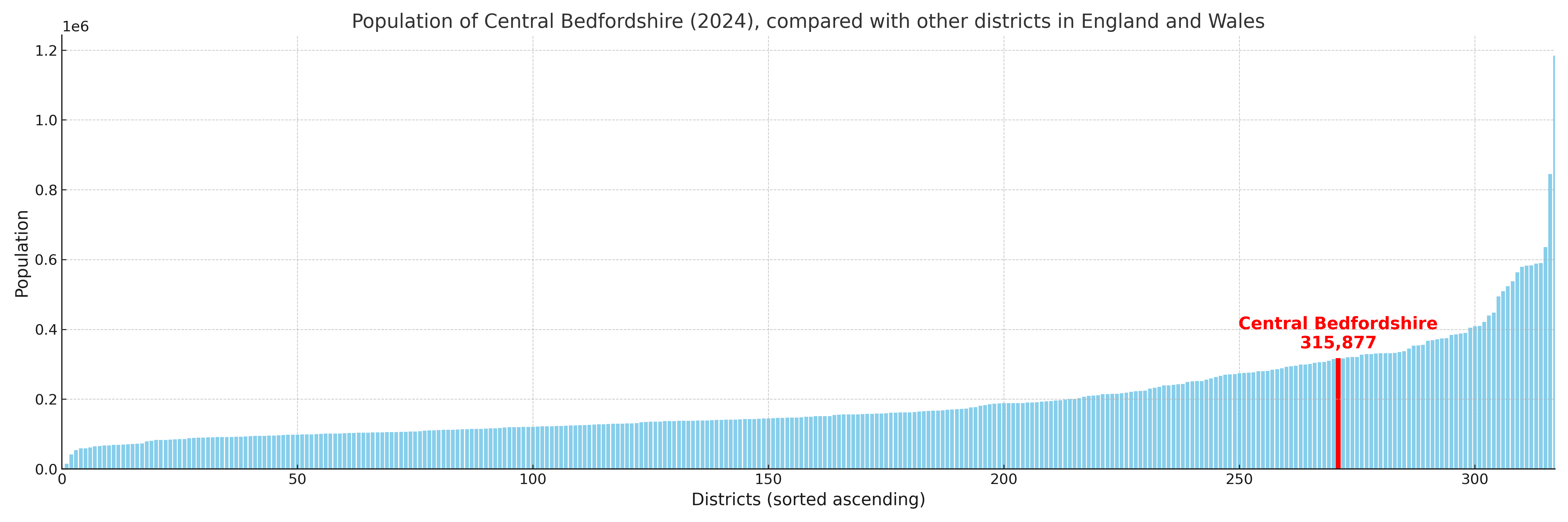
Central Bedfordshire compared with other districts in the UK
This section shows how Central Bedfordshire compares with other local authority districts in the UK, using a variety of measures and rankings.
Central Bedfordshire has 31 electoral wards.

Central Bedfordshire has a population of 315,877 (2024 mid-year estimate by ONS)
Population and Migration Trends in Central Bedfordshire
This chart shows the population trend for Central Bedfordshire from 2015 to 2024. It provides a quick overview of whether the local authority is growing, stable, or declining over time, and helps set context for the migration patterns shown below.
Population change is influenced by natural change (births minus deaths) and migration. The net migration chart below focuses on migration, separating internal migration (moves within the UK) from international migration (moves to and from abroad). Positive values indicate net inflows, while negative values indicate net outflows. The rate labels (per 1,000 residents) help compare migration intensity across years, even when the population size changes.
More local statistics and data for Central Bedfordshire can be found on the ONS statistics for Central Bedfordshire.
Latest news about Central Bedfordshire
Use the search box, or suggested search phrases, below to find recent news, council updates, planning stories, housing developments, transport changes, public services news, local elections, community issues and other local developments related to Central Bedfordshire. Results may include coverage from UK national, regional and local news websites, as well as official public-sector and local democracy sources.
- Central Bedfordshire council
- Central Bedfordshire planning
- Central Bedfordshire local elections
- Central Bedfordshire housing
- Central Bedfordshire transport
- Central Bedfordshire regeneration
- Central Bedfordshire public services