East Hertfordshire
§ This page gives an overview of the East Hertfordshire local authority district, bringing together key facts, maps, and data to help you quickly understand the area. This is one of 361 LAD profiles on Baseview.
Overview ⁞ East Hertfordshire covers a wide expanse of rural countryside with market towns and historic villages. Hertford, the county town, has a riverside setting with historic buildings and cultural amenities, while Bishop’s Stortford serves as a lively commercial hub close to Stansted Airport. Ware, with its riverside attractions, and Sawbridgeworth, with its historic high street, add character. The River Lea and Stort valleys shape the district, alongside farmland and scattered woodlands. Picturesque villages and heritage sites are spread across the area, making it a blend of countryside charm and commuter convenience.
East Hertfordshire Boundary Map
This map shows the official boundary of the East Hertfordshire local authority district, based on the latest geographic data published by the Office for National Statistics (ONS). It provides a clear view of the district’s extent and helps you understand how the area fits within the wider regional and national landscape.
Contains OS data © Crown copyright and database right 2025. Source: Office for National Statistics licensed under the Open Government Licence v3.0.
The administrative boundary of East Hertfordshire can also be viewed on OpenStreetMap: District Boundary of East Hertfordshire.
Key Facts about East Hertfordshire
What region is East Hertfordshire in? East Hertfordshire is in the East of England of England, a region within the UK.
What county is East Hertfordshire in? East Hertfordshire is located in the county of Hertfordshire.
Is East Hertfordshire a city? No, East Hertfordshire is not a city. (Note: the UK has 76 officially designated cities.)
Who governs East Hertfordshire? The local authority for this district is: East Hertfordshire District Council - responsible for district-level services. Since Hertfordshire is a two-tier area, county-level services are handled by: Hertfordshire County Council.
▶ Official website of East Hertfordshire District Council 🔗 eastherts.gov.uk
Which police force covers East Hertfordshire? Policing in East Hertfordshire is provided by Hertfordshire Constabulary 🔗 herts.police.uk, which serves 10 local authority districts: Broxbourne ⁞ Dacorum ⁞ East Hertfordshire ⁞ Hertsmere ⁞ North Hertfordshire ⁞ St Albans ⁞ Stevenage ⁞ Three Rivers ⁞ Watford ⁞ Welwyn Hatfield.
East Hertfordshire in International Geographies
In the International Territorial Levels (ITLs) hierarchy, East Hertfordshire is within an ITLs Level 3 area:
- (ITL 1) East of England
- (ITL 2) ⇒ Bedfordshire and Hertfordshire
- (ITL 3) ⇒⇒ North and East Hertfordshire
The International Territorial Levels are used by OECD member countries for statistical purposes to classify administrative areas. We have this listable page for easy browsing of ITL names and codes: International Territorial Levels.
Constituencies in East Hertfordshire
East Hertfordshire is divided into 4 parliamentary constituencies, listed below in alphabetical order.
A constituency is a specific geographical area that elects one Member of Parliament (MP) to represent them in the House of Commons. The United Kingdom is divided into 650 parliamentary constituencies. We have this list page for easy browsing of all UK parliamentary constituencies: List of Constituencies.
Wards in East Hertfordshire
East Hertfordshire is divided into 26 wards, listed below in alphabetical order.
- Aston, Datchworth & Walkern
- Bishop's Stortford All Saints
- Bishop's Stortford Central
- Bishop's Stortford North
- Bishop's Stortford Parsonage
- Bishop's Stortford South
- Bishop's Stortford Thorley Manor
- Braughing & Standon
- Buntingford
- Great Amwell & Stansteads
- Hertford Bengeo
- Hertford Castle
- Hertford Heath & Brickendon
- Hertford Kingsmead
- Hertford Rural
- Hertford Sele
- Hunsdon
- Little Hadham & The Pelhams
- Much Hadham
- Sawbridgeworth
- The Mundens
- Ware Priory
- Ware Rural
- Ware St Mary's
- Ware Trinity
- Watton-at-Stone
In the UK, a ward is a subdivision of a local authority area, used mainly for electoral and statistical purposes. Defined by the ONS, wards represent the primary unit for local elections, each returning one or more councillors to the local council. Wards are also used as a key geography for presenting population and census data. We have this list page for easy browsing of all electoral wards: List of all Electoral Wards in the UK.
Parishes in East Hertfordshire
East Hertfordshire is fully parished: 50 civil parishes, listed A-Z below.
- Albury
- Anstey
- Ardeley
- Aspenden
- Aston
- Bayford
- Bengeo Rural
- Benington
- Bishop's Stortford
- Bramfield
- Braughing
- Brent Pelham
- Brickendon Liberty
- Buckland
- Buntingford
- Cottered
- Datchworth
- Eastwick
- Furneux Pelham
- Gilston
- Great Amwell
- Great Munden
- Hertford
- Hertford Heath
- Hertingfordbury
- High Wych
- Hormead
- Hunsdon
- Little Berkhamsted
- Little Hadham
- Little Munden
- Meesden
- Much Hadham
- Sacombe
- Sawbridgeworth
- Standon
- Stanstead Abbots
- Stanstead St Margarets
- Stapleford
- Stocking Pelham
- Tewin
- Thorley
- Thundridge
- Walkern
- Ware
- Wareside
- Watton-at-Stone
- Westmill
- Widford
- Wyddial
A civil parish is the lowest tier of local government in England, used for villages, small towns, and suburbs. They have their own local authority, either a parish council or a parish meeting, which provides local services like managing parks, allotments, and streetlights, and represents the community's views to larger councils.
We have this list page for easy browsing of all parishes: List of Civil Parishes in England and Wales.
Post Towns in East Hertfordshire
Below is a list of post towns in East Hertfordshire, grouped by postcode area:
- CM ▸ Bishop's Stortford (CM22 / CM23) ⁞ Sawbridgeworth (CM21)
- SG ▸ Buntingford (SG9) ⁞ Hertford (SG13 / SG14) ⁞ Much Hadham (SG10) ⁞ Ware (SG11 / SG12)
The UK postal hierarchy begins with broad postcode areas (such as “CB” or “M”), which are divided into smaller postcode districts (such as “CB8” or “M1”) to support accurate mail routing. Each postal address is anchored by a designated post town, the official locality name used in the UK postcode system, which operates independently from Local Authority Districts —the administrative boundaries used for council tax and local government services. Because they serve different purposes, a property’s postal address and its local authority district do not always align exactly.
Built-up Areas in East Hertfordshire
East Hertfordshire covers 42 built-up areas, listed below in alphabetical order.
- Aston (East Hertfordshire) *
- Bayford
- Benington
- Birch Green
- Bishop's Stortford *
- Braughing
- Brickendon
- Buntingford
- Bury Green
- Cottered
- Dane End
- Datchworth *
- Great Amwell
- Great Hormead
- Hadham Cross
- Harlow *
- Hertford
- Hertford Heath
- High Cross
- Hoddesdon *
- Hunsdon
- Letty Green
- Little Berkhamsted
- Little Hadham
- Old Hall Green
- Perry Green
- Puckeridge and Standon
- Roydon (Epping Forest) *
- Sawbridgeworth *
- South-end
- Spellbrook *
- Stanstead Abbotts
- Stevenage *
- Tewin
- Tewin Wood *
- Thundridge and Wadesmill
- Walkern
- Ware
- Watton at Stone
- Wellpond Green
- Welwyn Garden City *
- Widford
In the UK, a Built-up Area (BUA) is a continuous urban area of at least 20 hectares (0.2 km²), defined by the ONS as land where buildings are generally no more than 200 metres apart, such as towns, cities, or large villages. (Note: A BUA name marked with an asterisk (*) indicates that the area is situated partly in the district of East Hertfordshire.)
We have this list page for easy browsing of all built-up areas: List of all Built-up Areas in GB.
Railway Stations in East Hertfordshire
East Hertfordshire is served by a number of National Rail stations, providing rail connections to nearby towns, cities, and destinations across Great Britain. The railway stations listed below are located within the East Hertfordshire Local Authority District and are grouped by train operating company for clarity.
- Govia Thameslink Railway (Great Northern) ▸ Hertford North (SG14 1NB) ⁞ Watton-At-Stone (SG14 3SH) ⁞ Bayford (SG13 8PH)
- Greater Anglia ▸ Bishops Stortford (CM23 3BL) ⁞ Hertford East (SG14 1SB) ⁞ Ware (Herts) (SG12 9UT) ⁞ Sawbridgeworth (CM21 9JZ) ⁞ St Margarets (Herts) (SG12 8DS) ⁞ Roydon (CM19 5EH)
This is a district-level view only. For a complete list of all National Rail stations across Great Britain, see the UK National Rail Stations Directory.
East Hertfordshire compared with other districts in the UK
This section shows how East Hertfordshire compares with other local authority districts in the UK, using a variety of measures and rankings.
East Hertfordshire has 26 electoral wards.

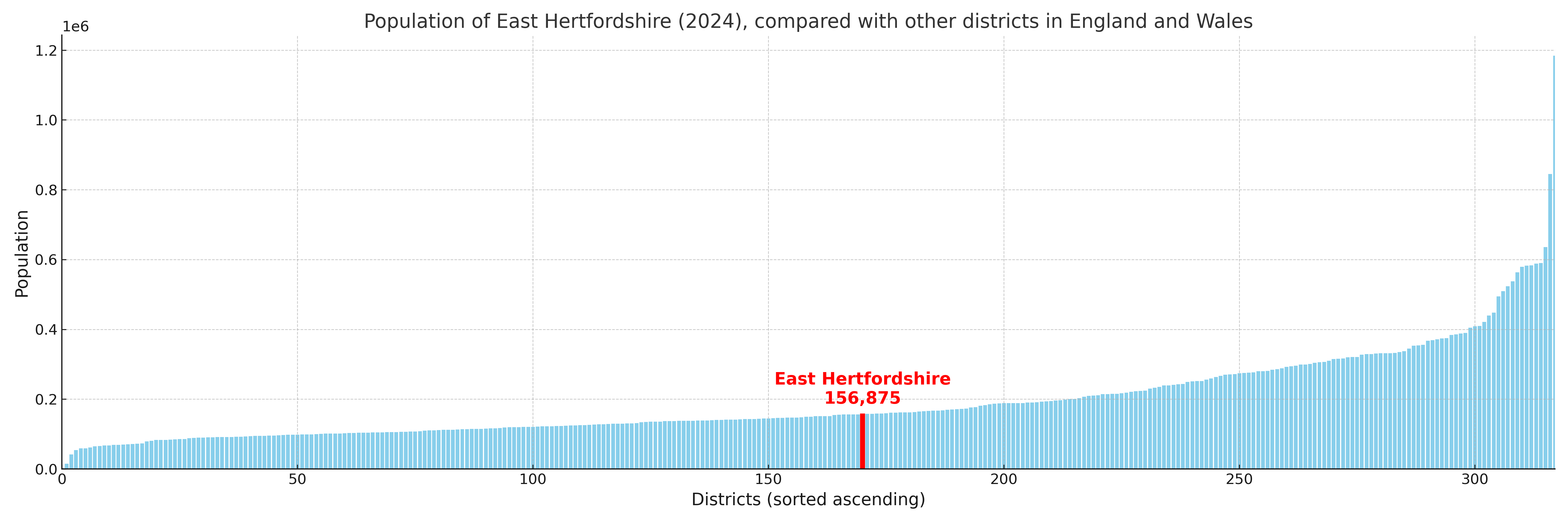
East Hertfordshire has a population of 156,875 (2024 mid-year estimate by ONS)
Population and Migration Trends in East Hertfordshire
This chart shows the population trend for East Hertfordshire from 2015 to 2024. It provides a quick overview of whether the local authority is growing, stable, or declining over time, and helps set context for the migration patterns shown below.
Population change is influenced by natural change (births minus deaths) and migration. The net migration chart below focuses on migration, separating internal migration (moves within the UK) from international migration (moves to and from abroad). Positive values indicate net inflows, while negative values indicate net outflows. The rate labels (per 1,000 residents) help compare migration intensity across years, even when the population size changes.
More local statistics and data for East Hertfordshire can be found on the ONS statistics for East Hertfordshire.
Latest news about East Hertfordshire
Use the search box, or suggested search phrases, below to find recent news, council updates, planning stories, housing developments, transport changes, public services news, local elections, community issues and other local developments related to East Hertfordshire. Results may include coverage from UK national, regional and local news websites, as well as official public-sector and local democracy sources.
- East Hertfordshire council
- East Hertfordshire planning
- East Hertfordshire local elections
- East Hertfordshire housing
- East Hertfordshire transport
- East Hertfordshire regeneration
- East Hertfordshire public services