Huntingdonshire
§ This page gives an overview of the Huntingdonshire local authority district, bringing together key facts, maps, and data to help you quickly understand the area. This is one of 361 LAD profiles on Baseview.
Overview ⁞ Huntingdonshire covers a mix of historic market towns, scenic river valleys, and picturesque villages in Cambridgeshire. Huntingdon, the principal town, is steeped in history as the birthplace of Oliver Cromwell, with traditional markets and riverside walks. St Ives, known for its medieval bridge and vibrant riverside, and St Neots, the largest town, with a bustling town centre and riverside parks, are key settlements. The River Great Ouse meanders through the district, offering boating, fishing, and scenic views, while nearby Grafham Water is a major reservoir popular for sailing and nature watching. The countryside is dotted with charming villages, woodlands, and open farmland, combining heritage with natural beauty.
Huntingdonshire Boundary Map
This map shows the official boundary of the Huntingdonshire local authority district, based on the latest geographic data published by the Office for National Statistics (ONS). It provides a clear view of the district’s extent and helps you understand how the area fits within the wider regional and national landscape.
Contains OS data © Crown copyright and database right 2025. Source: Office for National Statistics licensed under the Open Government Licence v3.0.
The administrative boundary of Huntingdonshire can also be viewed on OpenStreetMap: District Boundary of Huntingdonshire.
Key Facts about Huntingdonshire
What region is Huntingdonshire in? Huntingdonshire is in the East of England of England, a region within the UK.
What county is Huntingdonshire in? Huntingdonshire is located in the county of Cambridgeshire.
Is Huntingdonshire a city? No, Huntingdonshire is not a city. (Note: the UK has 76 officially designated cities.)
Who governs Huntingdonshire? The local authority for this district is: Huntingdonshire District Council - responsible for district-level services. Since Cambridgeshire is a two-tier area, county-level services are handled by: Cambridgeshire County Council.
▶ Official website of Huntingdonshire District Council 🔗 huntingdonshire.gov.uk
Which police force covers Huntingdonshire? Policing in Huntingdonshire is provided by Cambridgeshire Constabulary 🔗 cambs.police.uk, which serves 6 local authority districts: Cambridge ⁞ East Cambridgeshire ⁞ Fenland ⁞ Huntingdonshire ⁞ Peterborough ⁞ South Cambridgeshire.
Constituencies in Huntingdonshire
Huntingdonshire is divided into 3 parliamentary constituencies, listed below in alphabetical order.
A constituency is a specific geographical area that elects one Member of Parliament (MP) to represent them in the House of Commons. The United Kingdom is divided into 650 parliamentary constituencies. We have this list page for easy browsing of all UK parliamentary constituencies: List of Constituencies.
Wards in Huntingdonshire
Huntingdonshire is divided into 26 wards, listed below in alphabetical order.
- Alconbury
- Brampton
- Buckden
- Fenstanton
- Godmanchester & Hemingford Abbots
- Great Paxton
- Great Staughton
- Hemingford Grey & Houghton
- Holywell-cum-Needingworth
- Huntingdon East
- Huntingdon North
- Kimbolton
- Ramsey
- Sawtry
- Somersham
- St Ives East
- St Ives South
- St Ives West
- St Neots East
- St Neots Eatons
- St Neots Eynesbury
- St Neots Priory Park & Little Paxton
- Stilton, Folksworth & Washingley
- The Stukeleys
- Warboys
- Yaxley
In the UK, a ward is a subdivision of a local authority area, used mainly for electoral and statistical purposes. Defined by the ONS, wards represent the primary unit for local elections, each returning one or more councillors to the local council. Wards are also used as a key geography for presenting population and census data. We have this list page for easy browsing of all electoral wards: List of all Electoral Wards in the UK.
Parishes in Huntingdonshire
Huntingdonshire is fully parished: 81 civil parishes, listed A-Z below.
- Abbots Ripton
- Abbotsley
- Alconbury
- Alconbury Weston
- Alwalton
- Barham and Woolley
- Bluntisham
- Brampton
- Brington and Molesworth
- Broughton
- Buckden
- Buckworth
- Bury
- Bythorn and Keyston
- Catworth
- Chesterton
- Colne
- Conington
- Covington
- Denton and Caldecote
- Diddington
- Earith
- Easton
- Ellington
- Elton
- Farcet
- Fenstanton
- Folksworth and Washingley
- Glatton
- Godmanchester
- Grafham
- Great Gidding
- Great Gransden
- Great Paxton
- Great Staughton
- Haddon
- Hail Weston
- Hamerton and Steeple Gidding
- Hemingford Abbots
- Hemingford Grey
- Hilton
- Holme
- Holywell-cum-Needingworth
- Houghton and Wyton
- Huntingdon
- Kimbolton
- Kings Ripton
- Leighton
- Little Gidding
- Little Paxton
- Morborne
- Offord Cluny and Offord D'Arcy
- Old Hurst
- Old Weston
- Perry
- Pidley cum Fenton
- Ramsey
- Sawtry
- Sibson-cum-Stibbington
- Somersham
- Southoe and Midloe
- Spaldwick
- St. Ives
- St. Neots
- Stilton
- Stow Longa
- The Stukeleys
- Tilbrook
- Toseland
- Upton and Coppingford
- Upwood and the Raveleys
- Warboys
- Waresley-cum-Tetworth
- Water Newton
- Winwick
- Wistow
- Wood Walton
- Woodhurst
- Wyton-on-the-Hill
- Yaxley
- Yelling
A civil parish is the lowest tier of local government in England, used for villages, small towns, and suburbs. They have their own local authority, either a parish council or a parish meeting, which provides local services like managing parks, allotments, and streetlights, and represents the community's views to larger councils.
We have this list page for easy browsing of all parishes: List of Civil Parishes in England and Wales.
Post Towns in Huntingdonshire
Below is a list of post towns in Huntingdonshire, grouped by postcode area:
- PE ▸ Huntingdon (PE26 / PE28 / PE29) ⁞ St. Ives (PE27) ⁞ St. Neots (PE19)
The UK postal hierarchy begins with broad postcode areas (such as “CB” or “M”), which are divided into smaller postcode districts (such as “CB8” or “M1”) to support accurate mail routing. Each postal address is anchored by a designated post town, the official locality name used in the UK postcode system, which operates independently from Local Authority Districts —the administrative boundaries used for council tax and local government services. Because they serve different purposes, a property’s postal address and its local authority district do not always align exactly.
Built-up Areas in Huntingdonshire
Huntingdonshire covers 61 built-up areas, listed below in alphabetical order.
- Abbots Ripton
- Abbotsley
- Alconbury
- Alconbury Weald
- Alconbury Weston
- Bluntisham and Colne
- Brampton (Huntingdonshire)
- Brington
- Buckden
- Bury (Huntingdonshire)
- Catworth
- Earith *
- East Perry
- Ellington (Huntingdonshire)
- Elton (Huntingdonshire)
- Farcet *
- Fen Drayton *
- Fenstanton *
- Folksworth
- Glatton
- Godmanchester
- Great Gidding
- Great Gransden *
- Great Paxton
- Great Staughton
- Great Stukeley
- Hail Weston
- Hemingford Abbots
- Hemingford Grey
- Hilton (Huntingdonshire)
- Holme (Huntingdonshire)
- Houghton (Huntingdonshire)
- Huntingdon
- Kimbolton
- Little Gransden *
- Little Paxton
- Little Stukeley
- Needingworth
- Offord D'Arcy and Offord Cluny
- Peterborough *
- Pidley
- Ramsey
- Ramsey Forty Foot
- Ramsey Mereside
- Ramsey St Mary's
- Sawtry
- Somersham (Huntingdonshire)
- Spaldwick
- St Ives (Huntingdonshire)
- St Neots *
- Stilton
- Tilbrook
- Upwood
- Wansford *
- Warboys
- Waresley (Huntingdonshire)
- West Perry
- Wistow (Huntingdonshire)
- Wyton
- Yaxley (Huntingdonshire) *
- Yelling
In the UK, a Built-up Area (BUA) is a continuous urban area of at least 20 hectares (0.2 km²), defined by the ONS as land where buildings are generally no more than 200 metres apart, such as towns, cities, or large villages. (Note: A BUA name marked with an asterisk (*) indicates that the area is situated partly in the district of Huntingdonshire.)
We have this list page for easy browsing of all built-up areas: List of all Built-up Areas in GB.
Railway Stations in Huntingdonshire
Huntingdonshire is served by a number of National Rail stations, providing rail connections to nearby towns, cities, and destinations across Great Britain. The railway stations listed below are located within the Huntingdonshire Local Authority District and are grouped by train operating company for clarity.
- Govia Thameslink Railway (Great Northern) ▸ Huntingdon (PE29 3BP) ⁞ St Neots (PE19 1QF)
This is a district-level view only. For a complete list of all National Rail stations across Great Britain, see the UK National Rail Stations Directory.
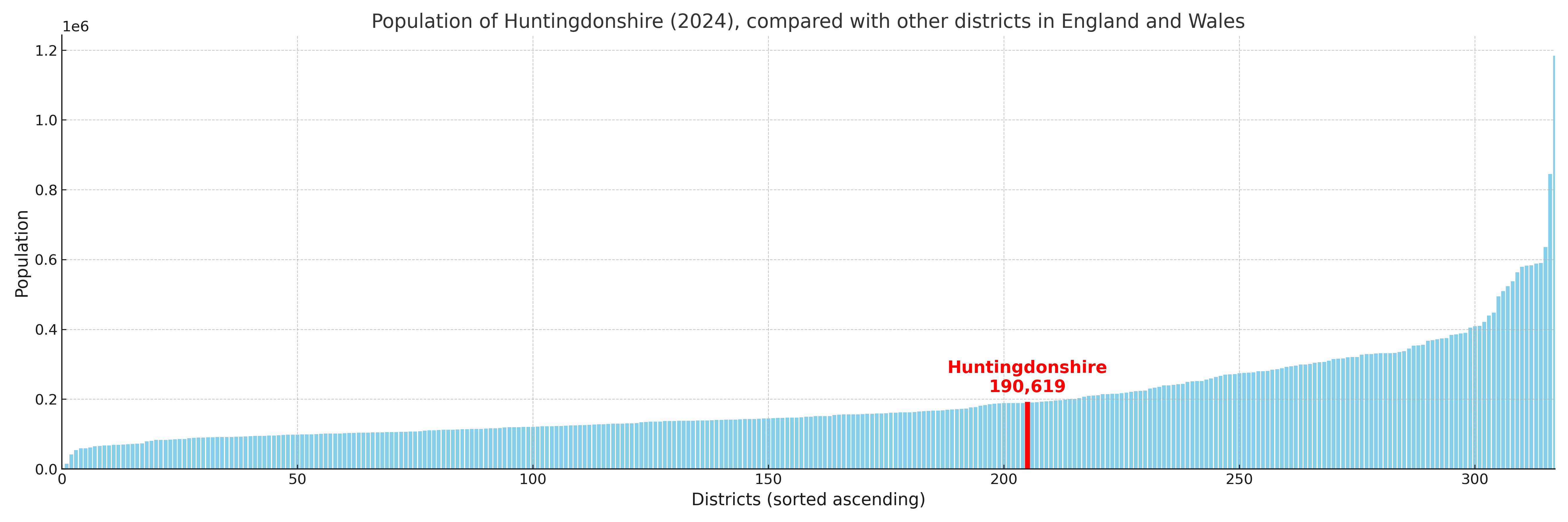
Huntingdonshire compared with other districts in the UK
This section shows how Huntingdonshire compares with other local authority districts in the UK, using a variety of measures and rankings.
Huntingdonshire has 26 electoral wards.

Huntingdonshire has a population of 190,619 (2024 mid-year estimate by ONS)
Population and Migration Trends in Huntingdonshire
This chart shows the population trend for Huntingdonshire from 2015 to 2024. It provides a quick overview of whether the local authority is growing, stable, or declining over time, and helps set context for the migration patterns shown below.
Population change is influenced by natural change (births minus deaths) and migration. The net migration chart below focuses on migration, separating internal migration (moves within the UK) from international migration (moves to and from abroad). Positive values indicate net inflows, while negative values indicate net outflows. The rate labels (per 1,000 residents) help compare migration intensity across years, even when the population size changes.
More local statistics and data for Huntingdonshire can be found on the ONS statistics for Huntingdonshire.
Latest news about Huntingdonshire
Use the search box, or suggested search phrases, below to find recent news, council updates, planning stories, housing developments, transport changes, public services news, local elections, community issues and other local developments related to Huntingdonshire. Results may include coverage from UK national, regional and local news websites, as well as official public-sector and local democracy sources.
- Huntingdonshire council
- Huntingdonshire planning
- Huntingdonshire local elections
- Huntingdonshire housing
- Huntingdonshire transport
- Huntingdonshire regeneration
- Huntingdonshire public services