West Suffolk
§ This page gives an overview of the West Suffolk local authority district, bringing together key facts, maps, and data to help you quickly understand the area. This is one of 361 LAD profiles on Baseview.
Overview ⁞ West Suffolk covers a broad swathe of the county, combining historic towns, chalk hills, and wide expanses of countryside. Bury St Edmunds, the main centre, is famed for its cathedral, abbey ruins, Georgian architecture, and cultural venues, offering a rich historic core. Newmarket, straddling the boundary with Cambridgeshire, is world-famous as the home of British horse racing, with its racecourses, training grounds, and equestrian heritage. Haverhill adds a modern, growing town to the mix, while smaller towns like Mildenhall and Brandon are surrounded by the heathlands and woodlands of The Brecks, an area of unique sandy soils and rare wildlife. The River Lark, River Kennet, and patches of rolling farmland create a varied geography, while villages dotted with medieval churches and timber-framed houses add rural charm. West Suffolk combines heritage, sporting tradition, and natural landscapes into a diverse district.
West Suffolk Boundary Map
This map shows the official boundary of the West Suffolk local authority district, based on the latest geographic data published by the Office for National Statistics (ONS). It provides a clear view of the district’s extent and helps you understand how the area fits within the wider regional and national landscape.
Contains OS data © Crown copyright and database right 2025. Source: Office for National Statistics licensed under the Open Government Licence v3.0.
The administrative boundary of West Suffolk can also be viewed on OpenStreetMap: District Boundary of West Suffolk.
Key Facts about West Suffolk
What region is West Suffolk in? West Suffolk is in the East of England of England, a region within the UK.
What county is West Suffolk in? West Suffolk is located in the county of Suffolk.
Is West Suffolk a city? No, West Suffolk is not a city. (Note: the UK has 76 officially designated cities.)
Who governs West Suffolk? The local authority for this district is: West Suffolk Council - responsible for district-level services. Since Suffolk is a two-tier area, county-level services are handled by: Suffolk County Council.
▶ Official website of West Suffolk Council 🔗 westsuffolk.gov.uk
Which police force covers West Suffolk? Policing in West Suffolk is provided by Suffolk Constabulary 🔗 suffolk.police.uk, which serves 5 local authority districts: Babergh ⁞ East Suffolk ⁞ Ipswich ⁞ Mid Suffolk ⁞ West Suffolk.
West Suffolk in International Geographies
In the International Territorial Levels (ITLs) hierarchy, West Suffolk is an ITLs Level 3 area:
- (ITL 1) East of England
- (ITL 2) ⇒ Suffolk
- (ITL 3) ⇒⇒ West Suffolk
The International Territorial Levels are used by OECD member countries for statistical purposes to classify administrative areas. We have this listable page for easy browsing of ITL names and codes: International Territorial Levels.
Constituencies in West Suffolk
West Suffolk is divided into 2 parliamentary constituencies, listed below in alphabetical order.
A constituency is a specific geographical area that elects one Member of Parliament (MP) to represent them in the House of Commons. The United Kingdom is divided into 650 parliamentary constituencies. We have this list page for easy browsing of all UK parliamentary constituencies: List of Constituencies.
Wards in West Suffolk
West Suffolk is divided into 43 wards, listed below in alphabetical order.
- Abbeygate
- Bardwell
- Barningham
- Barrow
- Brandon Central
- Brandon East
- Brandon West
- Chedburgh & Chevington
- Clare, Hundon & Kedington
- Eastgate
- Exning
- Haverhill Central
- Haverhill East
- Haverhill North
- Haverhill South
- Haverhill South East
- Haverhill West
- Horringer
- Iceni
- Ixworth
- Kentford & Moulton
- Lakenheath
- Manor
- Mildenhall Great Heath
- Mildenhall Kingsway & Market
- Mildenhall Queensway
- Minden
- Moreton Hall
- Newmarket East
- Newmarket North
- Newmarket West
- Pakenham & Troston
- Risby
- Rougham
- Southgate
- St Olaves
- Stanton
- The Fornhams & Great Barton
- The Rows
- Tollgate
- Westgate
- Whepstead & Wickhambrook
- Withersfield
In the UK, a ward is a subdivision of a local authority area, used mainly for electoral and statistical purposes. Defined by the ONS, wards represent the primary unit for local elections, each returning one or more councillors to the local council. Wards are also used as a key geography for presenting population and census data. We have this list page for easy browsing of all electoral wards: List of all Electoral Wards in the UK.
Parishes in West Suffolk
West Suffolk is fully parished: 103 civil parishes, listed A-Z below.
- Ampton
- Bardwell
- Barnardiston
- Barnham
- Barningham
- Barrow
- Barton Mills
- Beck Row, Holywell Row and Kenny Hill
- Bradfield Combust with Stanningfield
- Bradfield St. Clare
- Bradfield St. George
- Brandon
- Brockley
- Bury St Edmunds
- Cavendish
- Cavenham
- Chedburgh
- Chevington
- Clare
- Coney Weston
- Cowlinge
- Culford
- Dalham
- Denham
- Denston
- Depden
- Elveden
- Eriswell
- Euston
- Exning
- Fakenham Magna
- Flempton
- Fornham All Saints
- Fornham St. Genevieve
- Fornham St. Martin
- Freckenham
- Gazeley
- Great Barton
- Great Bradley
- Great Livermere
- Great Thurlow
- Great Whelnetham
- Great Wratting
- Hargrave
- Haverhill
- Hawkedon
- Hawstead
- Hengrave
- Hepworth
- Herringswell
- Higham
- Honington
- Hopton
- Horringer
- Hundon
- Icklingham
- Ickworth
- Ingham
- Ixworth
- Ixworth Thorpe
- Kedington
- Kentford
- Knettishall
- Lackford
- Lakenheath
- Lidgate
- Little Bradley
- Little Livermere
- Little Thurlow
- Little Whelnetham
- Little Wratting
- Market Weston
- Mildenhall High
- Moulton
- Newmarket
- Nowton
- Ousden
- Pakenham
- Poslingford
- Red Lodge
- Rede
- Risby
- Rushbrooke with Rougham
- Santon Downham
- Sapiston
- Stansfield
- Stanton
- Stoke-by-Clare
- Stradishall
- The Saxhams
- Thelnetham
- Timworth
- Troston
- Tuddenham
- West Row
- West Stow
- Westley
- Whepstead
- Wickhambrook
- Withersfield
- Wixoe
- Wordwell
- Worlington
A civil parish is the lowest tier of local government in England, used for villages, small towns, and suburbs. They have their own local authority, either a parish council or a parish meeting, which provides local services like managing parks, allotments, and streetlights, and represents the community's views to larger councils.
We have this list page for easy browsing of all parishes: List of Civil Parishes in England and Wales.
Post Towns in West Suffolk
Below is a list of post towns in West Suffolk, grouped by postcode area:
- CB ▸ Haverhill (CB9) ⁞ Newmarket (CB8)
- IP ▸ Brandon (IP27) ⁞ Bury St. Edmunds (IP28 / IP29 / IP30 / IP31 / IP32 / IP33)
The UK postal hierarchy begins with broad postcode areas (such as “CB” or “M”), which are divided into smaller postcode districts (such as “CB8” or “M1”) to support accurate mail routing. Each postal address is anchored by a designated post town, the official locality name used in the UK postcode system, which operates independently from Local Authority Districts —the administrative boundaries used for council tax and local government services. Because they serve different purposes, a property’s postal address and its local authority district do not always align exactly.
Built-up Areas in West Suffolk
West Suffolk covers 57 built-up areas, listed below in alphabetical order.
- Ashley (East Cambridgeshire) *
- Bardwell
- Barnham (West Suffolk)
- Barningham
- Barrow (West Suffolk)
- Barton Mills
- Beck Row
- Brandon (West Suffolk) *
- Bury St Edmunds
- Cavendish *
- Chedburgh
- Chevington
- Clare *
- Cock and End
- Coney Weston
- Culford
- Exning
- Fakenham Magna
- Fornham All Saints
- Fornham St Martin
- Freckenham
- Gazeley
- Great Barton
- Haverhill *
- Holywell Row
- Hopton
- Horringer
- Hundon
- Icklingham
- Ingham (West Suffolk)
- Ixworth
- Kedington
- Kentford *
- Lackford
- Lakenheath
- Landwade *
- Lidgate
- Little Eriswell
- Longfield Green
- Market Weston
- Mildenhall (West Suffolk)
- Moulton (West Suffolk)
- Newmarket *
- Ousden
- Pakenham *
- Red Lodge *
- Risby
- Sicklesmere
- Snailwell *
- Stanton (West Suffolk)
- Stoke-by-Clare
- Thurston *
- Tuddenham
- Upthorpe (West Suffolk) *
- West Row
- Wickhambrook
- Worlington
In the UK, a Built-up Area (BUA) is a continuous urban area of at least 20 hectares (0.2 km²), defined by the ONS as land where buildings are generally no more than 200 metres apart, such as towns, cities, or large villages. (Note: A BUA name marked with an asterisk (*) indicates that the area is situated partly in the district of West Suffolk.)
We have this list page for easy browsing of all built-up areas: List of all Built-up Areas in GB.
Railway Stations in West Suffolk
West Suffolk is served by a number of National Rail stations, providing rail connections to nearby towns, cities, and destinations across Great Britain. The railway stations listed below are located within the West Suffolk Local Authority District and are grouped by train operating company for clarity.
- Greater Anglia ▸ Bury St Edmunds (IP32 6AD) ⁞ Newmarket (CB8 9BB) ⁞ Dullingham (CB8 8UP) ⁞ Lakenheath (IP27 9AD)
This is a district-level view only. For a complete list of all National Rail stations across Great Britain, see the UK National Rail Stations Directory.
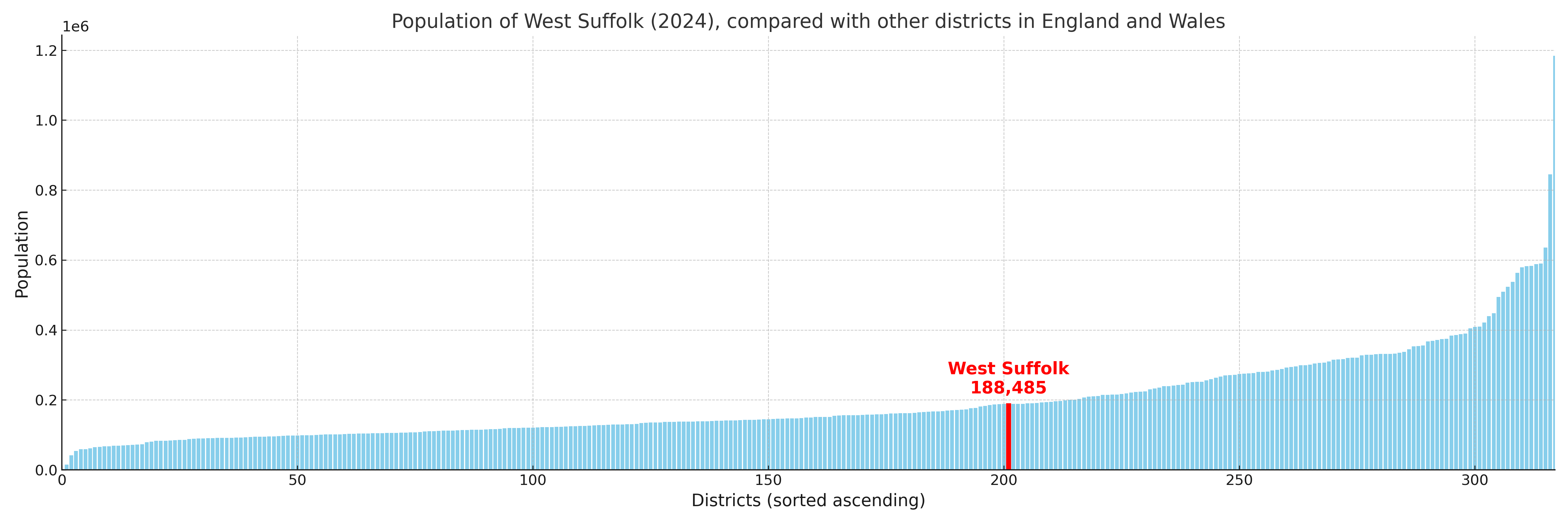
West Suffolk compared with other districts in the UK
This section shows how West Suffolk compares with other local authority districts in the UK, using a variety of measures and rankings.
West Suffolk has 43 electoral wards.

West Suffolk has a population of 188,485 (2024 mid-year estimate by ONS)
Population and Migration Trends in West Suffolk
This chart shows the population trend for West Suffolk from 2015 to 2024. It provides a quick overview of whether the local authority is growing, stable, or declining over time, and helps set context for the migration patterns shown below.
Population change is influenced by natural change (births minus deaths) and migration. The net migration chart below focuses on migration, separating internal migration (moves within the UK) from international migration (moves to and from abroad). Positive values indicate net inflows, while negative values indicate net outflows. The rate labels (per 1,000 residents) help compare migration intensity across years, even when the population size changes.
More local statistics and data for West Suffolk can be found on the ONS statistics for West Suffolk.
Latest news about West Suffolk
Use the search box, or suggested search phrases, below to find recent news, council updates, planning stories, housing developments, transport changes, public services news, local elections, community issues and other local developments related to West Suffolk. Results may include coverage from UK national, regional and local news websites, as well as official public-sector and local democracy sources.
- West Suffolk council
- West Suffolk planning
- West Suffolk local elections
- West Suffolk housing
- West Suffolk transport
- West Suffolk regeneration
- West Suffolk public services