Calderdale
§ This page gives an overview of the Calderdale local authority district, bringing together key facts, maps, and data to help you quickly understand the area. This is one of 361 LAD profiles on Baseview.
Overview ⁞ Calderdale, in West Yorkshire, is a district shaped by the steep-sided valleys of the River Calder and surrounding Pennine hills. Halifax, the main town, is known for the Piece Hall, a Georgian cloth hall, and Shibden Hall, a Tudor manor set in parkland. Market towns such as Hebden Bridge and Todmorden have thriving arts and cultural scenes, with historic mills converted into galleries and cafes. The rugged moorland landscapes of the South Pennines surround the towns, offering walking routes, reservoirs, and dramatic views. Villages built of gritstone cling to hillsides, adding to Calderdale’s unique character of industrial heritage set within wild countryside.
Calderdale Boundary Map
This map shows the official boundary of the Calderdale local authority district, based on the latest geographic data published by the Office for National Statistics (ONS). It provides a clear view of the district’s extent and helps you understand how the area fits within the wider regional and national landscape.
Contains OS data © Crown copyright and database right 2025. Source: Office for National Statistics licensed under the Open Government Licence v3.0.
The administrative boundary of Calderdale can also be viewed on OpenStreetMap: District Boundary of Calderdale.
Key Facts about Calderdale
What region is Calderdale in? Calderdale is in the Yorkshire and The Humber of England, a region within the UK.
What county is Calderdale in? Calderdale is located in the county of West Yorkshire.
Is Calderdale a city? No, Calderdale is not a city. (Note: the UK has 76 officially designated cities.)
Who governs Calderdale? The local government for this district is: Calderdale Borough Council (Metropolitan District).
▶ Official website of Calderdale Borough Council 🔗 calderdale.gov.uk
Which police force covers Calderdale? Policing in Calderdale is provided by West Yorkshire Police 🔗 westyorkshire.police.uk, which serves 5 local authority districts: Bradford ⁞ Calderdale ⁞ Kirklees ⁞ Leeds ⁞ Wakefield.
Calderdale in International Geographies
In the International Territorial Levels (ITLs) hierarchy, Calderdale is within an ITLs Level 3 area:
- (ITL 1) Yorkshire and The Humber
- (ITL 2) ⇒ West Yorkshire
- (ITL 3) ⇒⇒ Calderdale and Kirklees
The International Territorial Levels are used by OECD member countries for statistical purposes to classify administrative areas. We have this listable page for easy browsing of ITL names and codes: International Territorial Levels.
Constituencies in Calderdale
Calderdale is divided into 2 parliamentary constituencies, listed below in alphabetical order.
A constituency is a specific geographical area that elects one Member of Parliament (MP) to represent them in the House of Commons. The United Kingdom is divided into 650 parliamentary constituencies, 54 of them are in Yorkshire and the Humber region. We have this list page for easy browsing of all UK parliamentary constituencies: List of Constituencies.
Wards in Calderdale
Calderdale is divided into 17 wards, listed below in alphabetical order.
- Brighouse
- Calder
- Elland
- Greetland and Stainland
- Hipperholme and Lightcliffe
- Illingworth and Mixenden
- Luddendenfoot
- Northowram and Shelf
- Ovenden
- Park
- Rastrick
- Ryburn
- Skircoat
- Sowerby Bridge
- Todmorden
- Town
- Warley
In the UK, a ward is a subdivision of a local authority area, used mainly for electoral and statistical purposes. Defined by the ONS, wards represent the primary unit for local elections, each returning one or more councillors to the local council. Wards are also used as a key geography for presenting population and census data. We have this list page for easy browsing of all electoral wards: List of all Electoral Wards in the UK.
Parishes in Calderdale
Calderdale is part-parished: 8 civil parishes (listed A-Z below) alongside 3 unparished areas.
- Blackshaw
- Erringden
- Hebden Royd
- Heptonstall
- Ripponden
- Stainland and District
- Todmorden
- Wadsworth
A civil parish is the lowest tier of local government in England, used for villages, small towns, and suburbs. They have their own local authority, either a parish council or a parish meeting, which provides local services like managing parks, allotments, and streetlights, and represents the community's views to larger councils.
We have this list page for easy browsing of all parishes: List of Civil Parishes in England and Wales.
Post Towns in Calderdale
Below is a list of post towns in Calderdale, grouped by postcode area:
- HD ▸ Brighouse (HD6)
- HX ▸ Elland (HX1 / HX5) ⁞ Halifax (HX1 / HX2 / HX3 / HX4) ⁞ Hebden Bridge (HX7) ⁞ Sowerby Bridge (HX6)
- OL ▸ Todmorden (OL14)
The UK postal hierarchy begins with broad postcode areas (such as “CB” or “M”), which are divided into smaller postcode districts (such as “CB8” or “M1”) to support accurate mail routing. Each postal address is anchored by a designated post town, the official locality name used in the UK postcode system, which operates independently from Local Authority Districts —the administrative boundaries used for council tax and local government services. Because they serve different purposes, a property’s postal address and its local authority district do not always align exactly.
Built-up Areas in Calderdale
Calderdale covers 22 built-up areas, listed below in alphabetical order.
- Barkisland
- Bradford *
- Brighouse *
- Cleckheaton *
- Cragg Vale
- Elland
- Halifax *
- Hebden Bridge
- Heptonstall
- Holywell Green and Stainland
- Huddersfield *
- Luddenden Foot
- Mirfield *
- Mytholmroyd
- Norwood Green
- Outlane *
- Ripponden
- Scholes (near Cleckheaton) *
- Shelf and Northowram *
- Sowerby Bridge
- Summit *
- Todmorden *
In the UK, a Built-up Area (BUA) is a continuous urban area of at least 20 hectares (0.2 km²), defined by the ONS as land where buildings are generally no more than 200 metres apart, such as towns, cities, or large villages. (Note: A BUA name marked with an asterisk (*) indicates that the area is situated partly in the district of Calderdale.)
We have this list page for easy browsing of all built-up areas: List of all Built-up Areas in GB.
Railway Stations in Calderdale
Calderdale is served by a number of National Rail stations, providing rail connections to nearby towns, cities, and destinations across Great Britain. The railway stations listed below are located within the Calderdale Local Authority District and are grouped by train operating company for clarity.
- Northern Trains ▸ Halifax (HX1 1QE) ⁞ Hebden Bridge (HX7 6JE) ⁞ Todmorden (OL14 7AA) ⁞ Sowerby Bridge (HX6 3LB) ⁞ Brighouse (HD6 1LE) ⁞ Mytholmroyd (HX7 5DZ) ⁞ Walsden (OL14 7ST)
This is a district-level view only. For a complete list of all National Rail stations across Great Britain, see the UK National Rail Stations Directory.
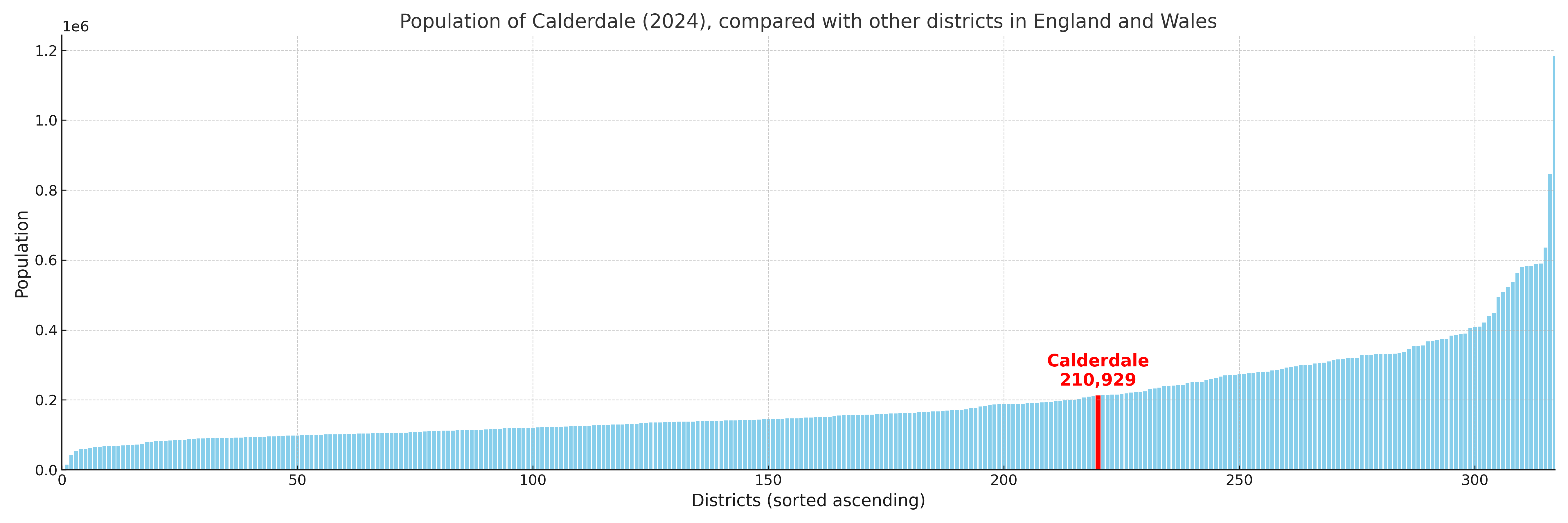
Calderdale compared with other districts in the UK
This section shows how Calderdale compares with other local authority districts in the UK, using a variety of measures and rankings.
Calderdale has 17 electoral wards.

Calderdale has a population of 210,929 (2024 mid-year estimate by ONS)
Population and Migration Trends in Calderdale
This chart shows the population trend for Calderdale from 2015 to 2024. It provides a quick overview of whether the local authority is growing, stable, or declining over time, and helps set context for the migration patterns shown below.
Population change is influenced by natural change (births minus deaths) and migration. The net migration chart below focuses on migration, separating internal migration (moves within the UK) from international migration (moves to and from abroad). Positive values indicate net inflows, while negative values indicate net outflows. The rate labels (per 1,000 residents) help compare migration intensity across years, even when the population size changes.
More local statistics and data for Calderdale can be found on the ONS statistics for Calderdale.
Latest news about Calderdale
Use the search box, or suggested search phrases, below to find recent news, council updates, planning stories, housing developments, transport changes, public services news, local elections, community issues and other local developments related to Calderdale. Results may include coverage from UK national, regional and local news websites, as well as official public-sector and local democracy sources.
- Calderdale council
- Calderdale planning
- Calderdale local elections
- Calderdale housing
- Calderdale transport
- Calderdale regeneration
- Calderdale public services