Scunthorpe
§ This page provides a baseview of UK constituency, bringing together various information and resources to help you better understand the area of Scunthorpe.
Overview ⁞ Scunthorpe is a parliamentary constituency in North Lincolnshire, centred on the industrial town of Scunthorpe, which is historically known for its steel production and manufacturing heritage. The area combines urban neighbourhoods, retail centres, and residential suburbs with pockets of surrounding countryside. It includes the communities of Bottesford, Ashby, and parts of Crosby, as well as nearby villages such as Burringham and Gunness along the River Trent. The landscape is relatively flat, with agricultural land and transport links connecting it to the Humber region and the wider East Midlands. Local landmarks include Central Park, Ashby Ville Nature Reserve, and the nearby Lincolnshire Wolds to the southeast.
Constituency Map and Boundary Information
Below is an interactive map showing the boundary of the Scunthorpe parliamentary constituency. The boundary data is sourced from the Office for National Statistics (ONS), using the latest official geographic definitions.
You can explore official statistics for this area on the ONS Explore Local Statistics page, or view its location on the UK Parliament constituency map.
Map tiles © OpenStreetMap contributors. Boundary data: Contains Ordnance Survey data © Crown copyright and database right 2024; Contains Office for National Statistics data © ONS 2024, licensed under the Open Government Licence v3.0.
Wards in Scunthorpe Constituency
There are 14 wards, listed below in alphabetical order.
- Ashby Central
- Ashby Lakeside
- Bottesford
- Brigg & Wolds
- Broughton & Scawby
- Brumby
- Burringham & Gunness
- Burton upon Stather & Winterton
- Crosby & Park
- Frodingham
- Kingsway with Lincoln Gardens
- Messingham
- Ridge
- Town
Scunthorpe is a constituency that covers these wards in North Lincolnshire.
Population by age group
Scunthorpe Population ⁞ The most recent data for constituencies in England and Wales comes from mid-year estimates for 2022. This tells us what the population was estimated to be on 30 June 2022.
| Age Band | Constituency (Number) | Constituency (%) | Region (Number) | Region (%) | England & Wales (Number) | England & Wales (%) |
|---|---|---|---|---|---|---|
| 0 to 17 | 22,585 | 21.36% | 1,157,053 | 20.88% | 12,506,535 | 20.76% |
| 18 to 24 | 7,191 | 6.80% | 485,848 | 8.77% | 5,008,522 | 8.31% |
| 25 to 34 | 13,381 | 12.65% | 726,186 | 13.11% | 8,098,257 | 13.44% |
| 35 to 49 | 19,385 | 18.33% | 1,017,489 | 18.36% | 11,575,752 | 19.22% |
| 50 to 64 | 21,408 | 20.24% | 1,092,608 | 19.72% | 11,745,365 | 19.50% |
| 65 and over | 21,802 | 20.62% | 1,062,078 | 19.17% | 11,303,607 | 18.76% |
Population by ethnic group
Scunthorpe Ethnicity ⁞ The most recent census asked people about their ethnic group. The census was carried out in March 2021 in England, Wales and Northern Ireland and in March 2022 in Scotland.
| Ethnic Group | Constituency (Number) | Constituency (%) | Region (%) | England & Wales (%) |
|---|---|---|---|---|
| English, Welsh, Scottish, Northern Irish or British | 88,833 | 84.24% | 80.85% | 74.42% |
| Other White | 7,589 | 7.20% | 3.80% | 6.15% |
| Bangladeshi | 1,796 | 1.70% | 0.53% | 1.08% |
| Other Asian | 1,037 | 0.98% | 0.92% | 1.63% |
| Any other ethnic group | 1,033 | 0.98% | 0.98% | 1.55% |
| Indian | 976 | 0.93% | 1.48% | 3.13% |
| Pakistani | 953 | 0.90% | 5.41% | 2.66% |
| African | 583 | 0.55% | 1.48% | 2.50% |
| White and Asian | 524 | 0.50% | 0.67% | 0.82% |
| Irish | 370 | 0.35% | 0.46% | 0.85% |
| Chinese | 345 | 0.33% | 0.54% | 0.75% |
| Other Mixed or Multiple ethnic groups | 333 | 0.32% | 0.46% | 0.78% |
| White and Black Caribbean | 243 | 0.23% | 0.72% | 0.86% |
| Roma | 209 | 0.20% | 0.17% | 0.17% |
| White and Black African | 208 | 0.20% | 0.29% | 0.42% |
| Arab | 204 | 0.19% | 0.46% | 0.56% |
| Gypsy or Irish Traveller | 103 | 0.10% | 0.11% | 0.11% |
| Caribbean | 65 | 0.06% | 0.41% | 1.05% |
| Other Black | 48 | 0.05% | 0.26% | 0.50% |
Scunthorpe compared with other constituencies
Scunthorpe has a population of 106,865 (2024 mid-year estimate by ONS). The population of the UK is 69,281,400 as of mid-2024. There are 650 constituencies, so the average population per constituency is around 106,600.
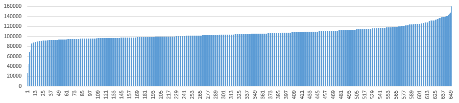
Compared with the other 649 constituencies, Scunthorpe has a population higher than 328, lower than 218, and similar to 104 constituencies (±2,500, including itself).
ONS Local Statistics for this Constituency
Understanding the social and economic characteristics of this constituency helps residents, community groups, researchers and businesses gain a clearer picture of the local area. ONS provides a wide set of local indicators that describe who lives here, how people work, their health, housing conditions and more.
Below, we highlight three useful measures — Household Deprivation, General Health, and Economic Activity Status — as an accessible introduction to the overall profile of Scunthorpe. These indicators offer a quick snapshot of living conditions, wellbeing and employment patterns.
Go to this ONS web page to explore all local indicators and build your custom profile for Scunthorpe.
ONS provides datasets of 38 indicators across six themes, covering a comprehensive range of local statistics for Scunthorpe:
- Demography and migration: Population, Number of households, Age profile, Sex, Live births, Deaths, Legal partnership status, Country of birth, Passports held, Length of residence in the UK, Household size, Household composition, Household deprivation.
- Economy: Distance travelled to work, Method of travel to workplace, Economic activity status, Employment history, Occupation, Socio-economic classification (NS-SeC), Hours per week worked.
- Education and skills: Highest level of qualification, Schoolchildren and full-time students.
- Ethnic group, national identity, language and religion: Ethnic group, National identity, Religion, Proficiency in English.
- Health and wellbeing: General health, Disability, Provision of unpaid care.
- Housing: Residential property sales, Energy efficiency of housing, Accommodation type, Number of cars or vans, Central heating, Number of bedrooms, Occupancy rating, Tenure of household, Second address indicator.
These indicators provide a well-rounded picture of Scunthorpe and allow you to compare local characteristics with other areas across the UK. The embedded charts just show a simplified starting point, and you are encouraged to explore the full ONS datasets for further detail.
Latest news about Scunthorpe
Use the search box or suggested search phrases below to find recent news, local updates, election coverage, public services stories, planning issues, transport updates and community developments related to Scunthorpe. Results may include coverage from UK national, regional and local news websites, as well as trusted public-interest sources.