Bradford
§ This page gives an overview of the Bradford local authority district, bringing together key facts, maps, and data to help you quickly understand the area. This is one of 361 LAD profiles on Baseview.
Overview ⁞ Bradford lies at the foothills of the Pennines in West Yorkshire, a city surrounded by valleys, moorland, and historic towns. The city centre is notable for its grand Victorian architecture, including City Hall, and cultural landmarks such as the Alhambra Theatre and National Science and Media Museum. The UNESCO World Heritage Site of Saltaire, a model village with historic mills and galleries, reflects Bradford’s textile heritage. The surrounding countryside includes Ilkley Moor and Brontë Country, with Haworth village linked to the Brontë sisters. Suburban towns such as Shipley, Keighley, and Bingley sit among green valleys, canals, and reservoirs, offering a mix of urban and rural scenery.
Bradford Boundary Map
This map shows the official boundary of the Bradford local authority district, based on the latest geographic data published by the Office for National Statistics (ONS). It provides a clear view of the district’s extent and helps you understand how the area fits within the wider regional and national landscape.
Contains OS data © Crown copyright and database right 2025. Source: Office for National Statistics licensed under the Open Government Licence v3.0.
The administrative boundary of Bradford can also be viewed on OpenStreetMap: District Boundary of Bradford.
Key Facts about Bradford
What region is Bradford in? Bradford is in the Yorkshire and The Humber of England, a region within the UK.
What county is Bradford in? Bradford is located in the county of West Yorkshire.
Is Bradford a city? Yes, Bradford is a city. Bradford holds official city status as one of the 76 designated cities in the UK.
Who governs Bradford? The local government for this district is: Bradford City Council (Metropolitan District).
▶ Official website of Bradford City Council 🔗 bradford.gov.uk
Which police force covers Bradford? Policing in Bradford is provided by West Yorkshire Police 🔗 westyorkshire.police.uk, which serves 5 local authority districts: Bradford ⁞ Calderdale ⁞ Kirklees ⁞ Leeds ⁞ Wakefield.
Bradford in International Geographies
In the International Territorial Levels (ITLs) hierarchy, Bradford is an ITLs Level 3 area:
- (ITL 1) Yorkshire and The Humber
- (ITL 2) ⇒ West Yorkshire
- (ITL 3) ⇒⇒ Bradford
The International Territorial Levels are used by OECD member countries for statistical purposes to classify administrative areas. We have this listable page for easy browsing of ITL names and codes: International Territorial Levels.
Constituencies in Bradford
Bradford is divided into 5 parliamentary constituencies, listed below in alphabetical order.
A constituency is a specific geographical area that elects one Member of Parliament (MP) to represent them in the House of Commons. The United Kingdom is divided into 650 parliamentary constituencies, 54 of them are in Yorkshire and the Humber region. We have this list page for easy browsing of all UK parliamentary constituencies: List of Constituencies.
Wards in Bradford
Bradford is divided into 30 wards, listed below in alphabetical order.
- Baildon
- Bingley
- Bingley Rural
- Bolton and Undercliffe
- Bowling and Barkerend
- Bradford Moor
- City
- Clayton and Fairweather Green
- Craven
- Eccleshill
- Great Horton
- Heaton
- Idle and Thackley
- Ilkley
- Keighley Central
- Keighley East
- Keighley West
- Little Horton
- Manningham
- Queensbury
- Royds
- Shipley
- Thornton and Allerton
- Toller
- Tong
- Wharfedale
- Wibsey
- Windhill and Wrose
- Worth Valley
- Wyke
In the UK, a ward is a subdivision of a local authority area, used mainly for electoral and statistical purposes. Defined by the ONS, wards represent the primary unit for local elections, each returning one or more councillors to the local council. Wards are also used as a key geography for presenting population and census data. We have this list page for easy browsing of all electoral wards: List of all Electoral Wards in the UK.
Parishes in Bradford
Bradford is part-parished: 21 civil parishes (listed A-Z below) alongside 10 unparished areas.
- Addingham
- Baildon
- Bingley
- Burley
- Clayton
- Cross Roads
- Cullingworth
- Denholme
- Harden
- Haworth and Stanbury
- Ilkley
- Keighley
- Menston
- Oxenhope
- Sandy Lane
- Shipley
- Silsden
- Steeton with Eastburn
- Trident
- Wilsden
- Wrose
A civil parish is the lowest tier of local government in England, used for villages, small towns, and suburbs. They have their own local authority, either a parish council or a parish meeting, which provides local services like managing parks, allotments, and streetlights, and represents the community's views to larger councils.
We have this list page for easy browsing of all parishes: List of Civil Parishes in England and Wales.
Post Towns in Bradford
Below is a list of post towns in Bradford, grouped by postcode area:
- BD ▸ Bingley (BD16 / BD97) ⁞ Bradford (BD1 / BD2 / BD3 / BD4 / BD5 / BD6 / BD7 / BD8 / BD9 / BD10 / BD11 / BD12 / BD13 / BD14 / BD15 / BD98 / BD99) ⁞ Keighley (BD20 / BD21 / BD22) ⁞ Shipley (BD17 / BD18 / BD98)
- LS ▸ Ilkley (LS29)
The UK postal hierarchy begins with broad postcode areas (such as “CB” or “M”), which are divided into smaller postcode districts (such as “CB8” or “M1”) to support accurate mail routing. Each postal address is anchored by a designated post town, the official locality name used in the UK postcode system, which operates independently from Local Authority Districts —the administrative boundaries used for council tax and local government services. Because they serve different purposes, a property’s postal address and its local authority district do not always align exactly.
Built-up Areas in Bradford
Bradford covers 32 built-up areas, listed below in alphabetical order.
- Addingham *
- Baildon
- Bingley
- Bradford *
- Brighouse *
- Burley in Wharfedale *
- Cross Hills *
- Cullingworth
- Denholme
- East Morton
- Esholt
- Gomersal and Birkenshaw *
- Guiseley *
- Halifax *
- Harden
- Haworth
- Ilkley *
- Keighley
- Menston *
- Oakenshaw *
- Oakworth
- Oxenhope
- Pudsey *
- Queensbury
- Rawdon *
- Shelf and Northowram *
- Shipley (Bradford)
- Silsden
- Steeton *
- Thornton (Bradford)
- Wilsden
- Yeadon *
In the UK, a Built-up Area (BUA) is a continuous urban area of at least 20 hectares (0.2 km²), defined by the ONS as land where buildings are generally no more than 200 metres apart, such as towns, cities, or large villages. (Note: A BUA name marked with an asterisk (*) indicates that the area is situated partly in the district of Bradford.)
We have this list page for easy browsing of all built-up areas: List of all Built-up Areas in GB.
Railway Stations in Bradford
Bradford is served by a number of National Rail stations, providing rail connections to nearby towns, cities, and destinations across Great Britain. The railway stations listed below are located within the Bradford Local Authority District and are grouped by train operating company for clarity.
- Northern Trains ▸ Bradford Interchange (BD1 1TU) ⁞ Bradford Forster Square (BD1 4HY) ⁞ Keighley (BD21 4HP) ⁞ Ilkley (LS29 8HF) ⁞ Shipley (Yorks) (BD18 2JL) ⁞ Bingley (BD16 2NA) ⁞ Saltaire (BD18 3LQ) ⁞ Menston (LS29 6JH) ⁞ Burley-In-Wharfedale (LS29 4BE) ⁞ Steeton and Silsden (BD20 6RY) ⁞ Apperley Bridge (BD10 0FD) ⁞ Crossflatts (BD16 2RZ) ⁞ Frizinghall (BD9 4LD) ⁞ Low Moor (BD12 7BD) ⁞ Ben Rhydding (LS29 8ET) ⁞ Baildon (BD17 6HS)
This is a district-level view only. For a complete list of all National Rail stations across Great Britain, see the UK National Rail Stations Directory.
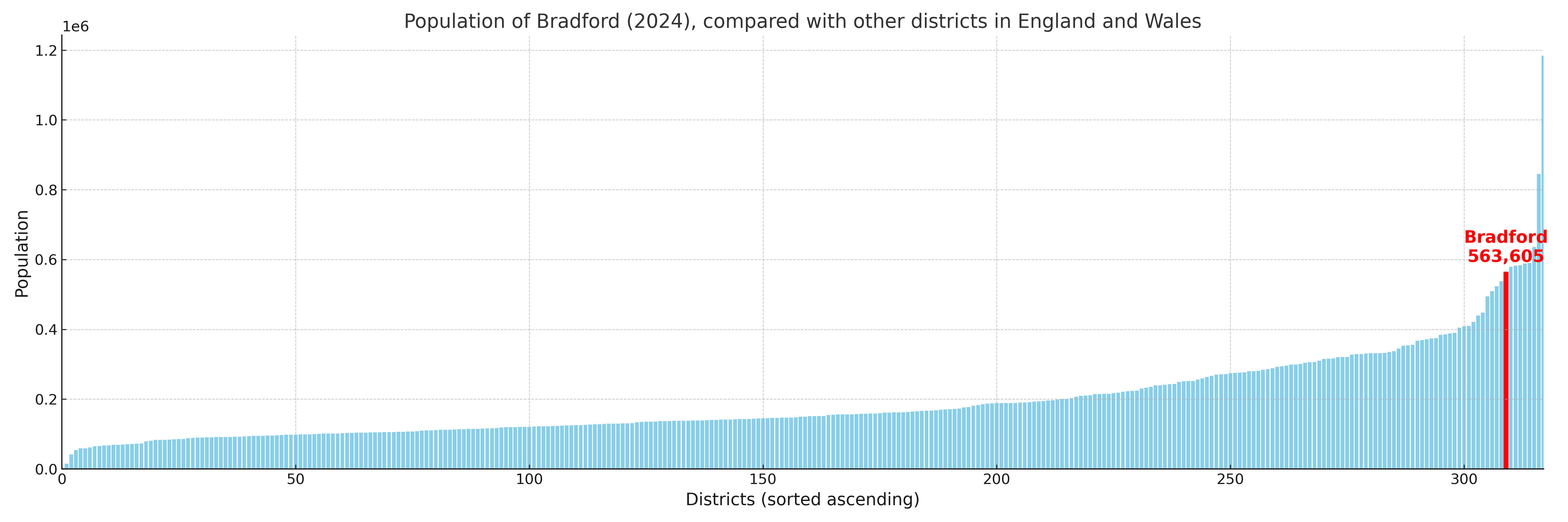
Bradford compared with other districts in the UK
This section shows how Bradford compares with other local authority districts in the UK, using a variety of measures and rankings.
Bradford has 30 electoral wards.

Bradford has a population of 563,605 (2024 mid-year estimate by ONS)
Population and Migration Trends in Bradford
This chart shows the population trend for Bradford from 2015 to 2024. It provides a quick overview of whether the local authority is growing, stable, or declining over time, and helps set context for the migration patterns shown below.
Population change is influenced by natural change (births minus deaths) and migration. The net migration chart below focuses on migration, separating internal migration (moves within the UK) from international migration (moves to and from abroad). Positive values indicate net inflows, while negative values indicate net outflows. The rate labels (per 1,000 residents) help compare migration intensity across years, even when the population size changes.
More local statistics and data for Bradford can be found on the ONS statistics for Bradford.
Latest news about Bradford
Use the search box, or suggested search phrases, below to find recent news, council updates, planning stories, housing developments, transport changes, public services news, local elections, community issues and other local developments related to Bradford. Results may include coverage from UK national, regional and local news websites, as well as official public-sector and local democracy sources.
- Bradford council
- Bradford planning
- Bradford local elections
- Bradford housing
- Bradford transport
- Bradford regeneration
- Bradford public services