North East Lincolnshire
§ This page gives an overview of the North East Lincolnshire local authority district, bringing together key facts, maps, and data to help you quickly understand the area. This is one of 361 LAD profiles on Baseview.
Overview ⁞ North East Lincolnshire lies on the southern bank of the Humber Estuary, with the seaside town of Cleethorpes as a popular resort featuring sandy beaches, a pier, and nature reserves along the coast. Grimsby, historically one of the world’s largest fishing ports, is known for its docklands, fishing heritage centres, and a redeveloped waterfront. The Lincolnshire Wolds border the district inland, providing rolling hills and rural villages. The estuary, coastal landscapes, and agricultural hinterland define the district’s character.
North East Lincolnshire Boundary Map
This map shows the official boundary of the North East Lincolnshire local authority district, based on the latest geographic data published by the Office for National Statistics (ONS). It provides a clear view of the district’s extent and helps you understand how the area fits within the wider regional and national landscape.
Contains OS data © Crown copyright and database right 2025. Source: Office for National Statistics licensed under the Open Government Licence v3.0.
The administrative boundary of North East Lincolnshire can also be viewed on OpenStreetMap: District Boundary of North East Lincolnshire.
Key Facts about North East Lincolnshire
What region is North East Lincolnshire in? North East Lincolnshire is in the Yorkshire and The Humber of England, a region within the UK.
What county is North East Lincolnshire in? North East Lincolnshire is in the county of Lincolnshire.
Is North East Lincolnshire a city? No, North East Lincolnshire is not a city. (Note: the UK has 76 officially designated cities.)
Who governs North East Lincolnshire? The local government for this district is: North East Lincolnshire Council (Unitary Authority).
▶ Official website of North East Lincolnshire Council 🔗 nelincs.gov.uk
Which police force covers North East Lincolnshire? Policing in North East Lincolnshire is provided by Humberside Police 🔗 humberside.police.uk, which serves 4 local authority districts: East Riding of Yorkshire ⁞ Kingston upon Hull, City of ⁞ North East Lincolnshire ⁞ North Lincolnshire.
North East Lincolnshire in International Geographies
In the International Territorial Levels (ITLs) hierarchy, North East Lincolnshire is within an ITLs Level 3 area:
- (ITL 1) Yorkshire and The Humber
- (ITL 2) ⇒ East Yorkshire and Northern Lincolnshire
- (ITL 3) ⇒⇒ North and North East Lincolnshire
The International Territorial Levels are used by OECD member countries for statistical purposes to classify administrative areas. We have this listable page for easy browsing of ITL names and codes: International Territorial Levels.
Constituencies in North East Lincolnshire
North East Lincolnshire is divided into 2 parliamentary constituencies, listed below in alphabetical order.
A constituency is a specific geographical area that elects one Member of Parliament (MP) to represent them in the House of Commons. The United Kingdom is divided into 650 parliamentary constituencies, 54 of them are in Yorkshire and the Humber region. We have this list page for easy browsing of all UK parliamentary constituencies: List of Constituencies.
Wards in North East Lincolnshire
North East Lincolnshire is divided into 15 wards, listed below in alphabetical order.
- Croft Baker
- East Marsh
- Freshney
- Haverstoe
- Heneage
- Humberston and New Waltham
- Immingham
- Park
- Scartho
- Sidney Sussex
- South
- Waltham
- West Marsh
- Wolds
- Yarborough
In the UK, a ward is a subdivision of a local authority area, used mainly for electoral and statistical purposes. Defined by the ONS, wards represent the primary unit for local elections, each returning one or more councillors to the local council. Wards are also used as a key geography for presenting population and census data. We have this list page for easy browsing of all electoral wards: List of all Electoral Wards in the UK.
Parishes in North East Lincolnshire
North East Lincolnshire is part-parished: 21 civil parishes (listed A-Z below) alongside 2 unparished areas.
- Ashby cum Fenby
- Aylesby
- Barnoldby le Beck
- Beelsby
- Bradley
- Brigsley
- East Ravendale
- Great Coates
- Habrough
- Hatcliffe
- Hawerby cum Beesby
- Healing
- Humberston
- Immingham
- Irby
- Laceby
- New Waltham
- Stallingborough
- Waltham
- West Ravendale
- Wold Newton
A civil parish is the lowest tier of local government in England, used for villages, small towns, and suburbs. They have their own local authority, either a parish council or a parish meeting, which provides local services like managing parks, allotments, and streetlights, and represents the community's views to larger councils.
We have this list page for easy browsing of all parishes: List of Civil Parishes in England and Wales.
Post Towns in North East Lincolnshire
Below is a list of post towns in North East Lincolnshire, grouped by postcode area:
- DN ▸ Cleethorpes (DN35) ⁞ Grimsby (DN31 / DN32 / DN33 / DN34 / DN36 / DN37 / DN41) ⁞ Immingham (DN40)
The UK postal hierarchy begins with broad postcode areas (such as “CB” or “M”), which are divided into smaller postcode districts (such as “CB8” or “M1”) to support accurate mail routing. Each postal address is anchored by a designated post town, the official locality name used in the UK postcode system, which operates independently from Local Authority Districts —the administrative boundaries used for council tax and local government services. Because they serve different purposes, a property’s postal address and its local authority district do not always align exactly.
Built-up Areas in North East Lincolnshire
North East Lincolnshire covers 13 built-up areas, listed below in alphabetical order.
- Barnoldby le Beck
- Brigsley
- Cleethorpes
- Grimsby
- Habrough
- Healing
- Holton le Clay *
- Humberston and New Waltham *
- Immingham *
- Laceby
- North Killingholme *
- Stallingborough
- Waltham
In the UK, a Built-up Area (BUA) is a continuous urban area of at least 20 hectares (0.2 km²), defined by the ONS as land where buildings are generally no more than 200 metres apart, such as towns, cities, or large villages. (Note: A BUA name marked with an asterisk (*) indicates that the area is situated partly in the district of North East Lincolnshire.)
We have this list page for easy browsing of all built-up areas: List of all Built-up Areas in GB.
Railway Stations in North East Lincolnshire
North East Lincolnshire is served by a number of National Rail stations, providing rail connections to nearby towns, cities, and destinations across Great Britain. The railway stations listed below are located within the North East Lincolnshire Local Authority District and are grouped by train operating company for clarity.
- Northern Trains ▸ Habrough (DN40 3AB) ⁞ Healing (DN37 7RY) ⁞ Great Coates (DN37 9NH) ⁞ Stallingborough (DN41 8AS) ⁞ Grimsby Docks (DN31 3PB) ⁞ New Clee (DN32 5GR)
- TransPennine Express ▸ Grimsby Town (DN31 1LY) ⁞ Cleethorpes (DN35 8AX)
This is a district-level view only. For a complete list of all National Rail stations across Great Britain, see the UK National Rail Stations Directory.
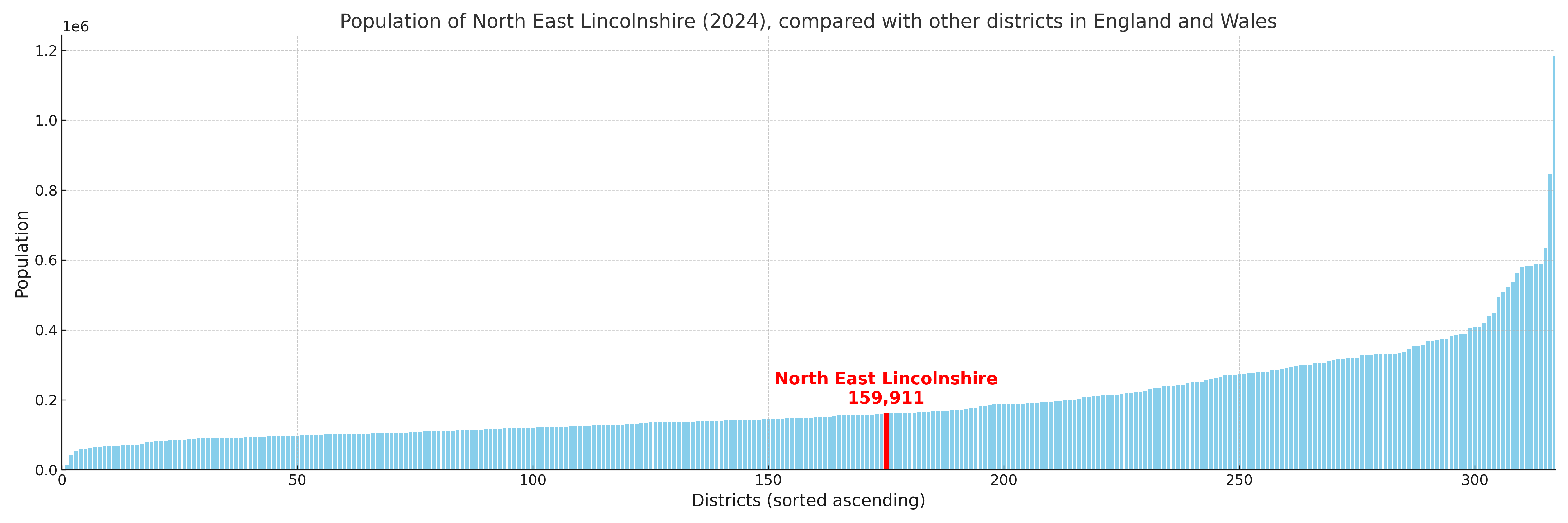
North East Lincolnshire compared with other districts in the UK
This section shows how North East Lincolnshire compares with other local authority districts in the UK, using a variety of measures and rankings.
North East Lincolnshire has 15 electoral wards.

North East Lincolnshire has a population of 159,911 (2024 mid-year estimate by ONS)
Population and Migration Trends in North East Lincolnshire
This chart shows the population trend for North East Lincolnshire from 2015 to 2024. It provides a quick overview of whether the local authority is growing, stable, or declining over time, and helps set context for the migration patterns shown below.
Population change is influenced by natural change (births minus deaths) and migration. The net migration chart below focuses on migration, separating internal migration (moves within the UK) from international migration (moves to and from abroad). Positive values indicate net inflows, while negative values indicate net outflows. The rate labels (per 1,000 residents) help compare migration intensity across years, even when the population size changes.
More local statistics and data for North East Lincolnshire can be found on the ONS statistics for North East Lincolnshire.
Latest news about North East Lincolnshire
Use the search box, or suggested search phrases, below to find recent news, council updates, planning stories, housing developments, transport changes, public services news, local elections, community issues and other local developments related to North East Lincolnshire. Results may include coverage from UK national, regional and local news websites, as well as official public-sector and local democracy sources.
- North East Lincolnshire council
- North East Lincolnshire planning
- North East Lincolnshire local elections
- North East Lincolnshire housing
- North East Lincolnshire transport
- North East Lincolnshire regeneration
- North East Lincolnshire public services