North Lincolnshire
§ This page gives an overview of the North Lincolnshire local authority district, bringing together key facts, maps, and data to help you quickly understand the area. This is one of 361 LAD profiles on Baseview.
Overview ⁞ North Lincolnshire spans from the Humber Bridge in the north to the rolling Lincolnshire Wolds and Trent Valley further south. Scunthorpe is the largest town, with a heritage in steel production and cultural venues like The Baths Hall. Market towns such as Brigg and Barton-upon-Humber add historic interest, the latter sitting at the foot of the Humber Bridge. The district’s geography includes flat agricultural land, the River Trent, and wetlands, with natural reserves such as Far Ings providing wildlife habitats. Its landscape is shaped by rivers, farmland, and historic settlements.
North Lincolnshire Boundary Map
This map shows the official boundary of the North Lincolnshire local authority district, based on the latest geographic data published by the Office for National Statistics (ONS). It provides a clear view of the district’s extent and helps you understand how the area fits within the wider regional and national landscape.
Contains OS data © Crown copyright and database right 2025. Source: Office for National Statistics licensed under the Open Government Licence v3.0.
The administrative boundary of North Lincolnshire can also be viewed on OpenStreetMap: District Boundary of North Lincolnshire.
Key Facts about North Lincolnshire
What region is North Lincolnshire in? North Lincolnshire is in the Yorkshire and The Humber of England, a region within the UK.
What county is North Lincolnshire in? North Lincolnshire is in the county of Lincolnshire.
Is North Lincolnshire a city? No, North Lincolnshire is not a city. (Note: the UK has 76 officially designated cities.)
Who governs North Lincolnshire? The local government for this district is: North Lincolnshire Council (Unitary Authority).
▶ Official website of North Lincolnshire Council 🔗 northlincs.gov.uk
Which police force covers North Lincolnshire? Policing in North Lincolnshire is provided by Humberside Police 🔗 humberside.police.uk, which serves 4 local authority districts: East Riding of Yorkshire ⁞ Kingston upon Hull, City of ⁞ North East Lincolnshire ⁞ North Lincolnshire.
Constituencies in North Lincolnshire
North Lincolnshire is divided into 3 parliamentary constituencies, listed below in alphabetical order.
A constituency is a specific geographical area that elects one Member of Parliament (MP) to represent them in the House of Commons. The United Kingdom is divided into 650 parliamentary constituencies, 54 of them are in Yorkshire and the Humber region. We have this list page for easy browsing of all UK parliamentary constituencies: List of Constituencies.
Wards in North Lincolnshire
North Lincolnshire is divided into 19 wards, listed below in alphabetical order.
- Ashby Central
- Ashby Lakeside
- Axholme Central
- Axholme North
- Axholme South
- Barton
- Bottesford
- Brigg & Wolds
- Broughton & Scawby
- Brumby
- Burringham & Gunness
- Burton upon Stather & Winterton
- Crosby & Park
- Ferry
- Frodingham
- Kingsway with Lincoln Gardens
- Messingham
- Ridge
- Town
In the UK, a ward is a subdivision of a local authority area, used mainly for electoral and statistical purposes. Defined by the ONS, wards represent the primary unit for local elections, each returning one or more councillors to the local council. Wards are also used as a key geography for presenting population and census data. We have this list page for easy browsing of all electoral wards: List of all Electoral Wards in the UK.
Parishes in North Lincolnshire
North Lincolnshire is part-parished: 56 civil parishes (listed A-Z below) alongside 1 unparished areas.
- Alkborough
- Amcotts
- Appleby
- Ashby Parkland
- Barnetby le Wold
- Barrow upon Humber
- Barton
- Belton
- Bonby
- Bottesford
- Brigg
- Broughton
- Burringham
- Burton upon Stather
- Cadney
- Crowle and Ealand
- Croxton
- East Butterwick
- East Halton
- Eastoft
- Elsham
- Epworth
- Flixborough
- Garthorpe and Fockerby
- Goxhill
- Gunness
- Haxey
- Hibaldstow
- Horkstow
- Keadby with Althorpe
- Kirmington
- Kirton in Lindsey
- Luddington and Haldenby
- Manton
- Melton Ross
- Messingham
- New Holland
- North Killingholme
- Owston Ferry
- Redbourne
- Roxby cum Risby
- Saxby All Saints
- Scawby
- South Ferriby
- South Killingholme
- Thornton Curtis
- Ulceby
- West Butterwick
- West Halton
- Whitton
- Winteringham
- Winterton
- Wootton
- Worlaby
- Wrawby
- Wroot
A civil parish is the lowest tier of local government in England, used for villages, small towns, and suburbs. They have their own local authority, either a parish council or a parish meeting, which provides local services like managing parks, allotments, and streetlights, and represents the community's views to larger councils.
We have this list page for easy browsing of all parishes: List of Civil Parishes in England and Wales.
Post Towns in North Lincolnshire
Below is a list of post towns in North Lincolnshire, grouped by postcode area:
- DN ▸ Barnetby (DN38) ⁞ Barrow-upon-Humber (DN19) ⁞ Barton-upon-Humber (DN18) ⁞ Brigg (DN20) ⁞ Scunthorpe (DN15 / DN16 / DN17) ⁞ Ulceby (DN39)
The UK postal hierarchy begins with broad postcode areas (such as “CB” or “M”), which are divided into smaller postcode districts (such as “CB8” or “M1”) to support accurate mail routing. Each postal address is anchored by a designated post town, the official locality name used in the UK postcode system, which operates independently from Local Authority Districts —the administrative boundaries used for council tax and local government services. Because they serve different purposes, a property’s postal address and its local authority district do not always align exactly.
Built-up Areas in North Lincolnshire
North Lincolnshire covers 50 built-up areas, listed below in alphabetical order.
- Alkborough
- Althorpe
- Amcotts
- Appleby
- Barnetby le Wold
- Barrow upon Humber
- Barton-upon-Humber
- Belton (North Lincolnshire)
- Bonby
- Brigg
- Broughton (North Lincolnshire)
- Burringham
- Burton upon Stather
- Crowle (North Lincolnshire)
- Ealand
- East Halton
- Eastoft
- Elsham
- Epworth
- Ferriby Sluice
- Garthorpe
- Goxhill
- Gunness
- Haxey
- Hibaldstow
- Howsham
- Immingham *
- Keadby
- Kirmington
- Kirton in Lindsey
- Messingham
- New Holland
- North Killingholme *
- Owston Ferry
- Redbourne
- Saxby All Saints
- Scawby
- Scawby Brook
- Scunthorpe
- South Ferriby
- South Killingholme
- Ulceby
- West Butterwick
- Westwoodside
- Winteringham
- Winterton
- Wootton (North Lincolnshire)
- Worlaby
- Wrawby
- Wroot *
In the UK, a Built-up Area (BUA) is a continuous urban area of at least 20 hectares (0.2 km²), defined by the ONS as land where buildings are generally no more than 200 metres apart, such as towns, cities, or large villages. (Note: A BUA name marked with an asterisk (*) indicates that the area is situated partly in the district of North Lincolnshire.)
We have this list page for easy browsing of all built-up areas: List of all Built-up Areas in GB.
Railway Stations in North Lincolnshire
North Lincolnshire is served by a number of National Rail stations, providing rail connections to nearby towns, cities, and destinations across Great Britain. The railway stations listed below are located within the North Lincolnshire Local Authority District and are grouped by train operating company for clarity.
- Northern Trains ▸ Barton-On-Humber (DN18 5SJ) ⁞ Crowle (DN17 4JS) ⁞ Goxhill (DN19 7HS) ⁞ New Holland (DN19 7BE) ⁞ Ulceby (DN39 6BE) ⁞ Althorpe (DN17 3HL) ⁞ Brigg (DN20 8HX) ⁞ Barrow Haven (DN19 7ET) ⁞ Kirton Lindsey (DN21 4BD) ⁞ Thornton Abbey (DN39 6XF)
- TransPennine Express ▸ Scunthorpe (DN15 6PY) ⁞ Barnetby (DN38 6DG)
This is a district-level view only. For a complete list of all National Rail stations across Great Britain, see the UK National Rail Stations Directory.
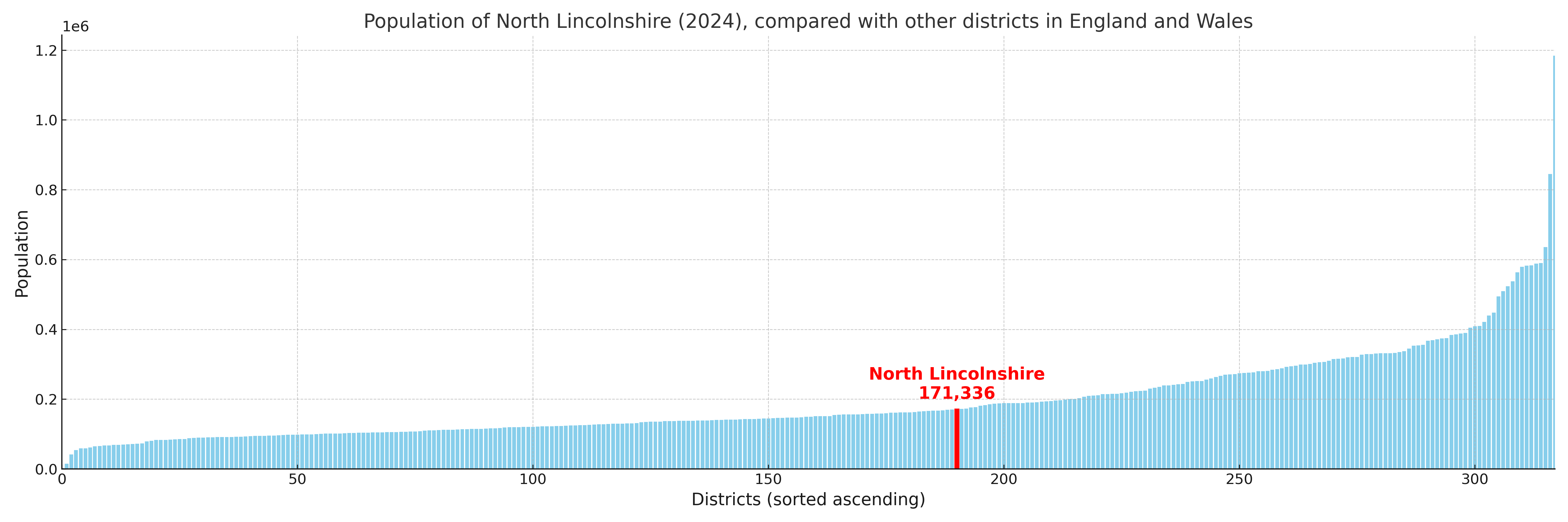
North Lincolnshire compared with other districts in the UK
This section shows how North Lincolnshire compares with other local authority districts in the UK, using a variety of measures and rankings.
North Lincolnshire has 19 electoral wards.

North Lincolnshire has a population of 171,336 (2024 mid-year estimate by ONS)
Population and Migration Trends in North Lincolnshire
This chart shows the population trend for North Lincolnshire from 2015 to 2024. It provides a quick overview of whether the local authority is growing, stable, or declining over time, and helps set context for the migration patterns shown below.
Population change is influenced by natural change (births minus deaths) and migration. The net migration chart below focuses on migration, separating internal migration (moves within the UK) from international migration (moves to and from abroad). Positive values indicate net inflows, while negative values indicate net outflows. The rate labels (per 1,000 residents) help compare migration intensity across years, even when the population size changes.
More local statistics and data for North Lincolnshire can be found on the ONS statistics for North Lincolnshire.
Latest news about North Lincolnshire
Use the search box, or suggested search phrases, below to find recent news, council updates, planning stories, housing developments, transport changes, public services news, local elections, community issues and other local developments related to North Lincolnshire. Results may include coverage from UK national, regional and local news websites, as well as official public-sector and local democracy sources.
- North Lincolnshire council
- North Lincolnshire planning
- North Lincolnshire local elections
- North Lincolnshire housing
- North Lincolnshire transport
- North Lincolnshire regeneration
- North Lincolnshire public services