East Riding of Yorkshire
§ This page gives an overview of the East Riding of Yorkshire local authority district, bringing together key facts, maps, and data to help you quickly understand the area. This is one of 361 LAD profiles on Baseview.
Overview ⁞ East Riding of Yorkshire lies on the east coast of England, bordering the North Sea and the Humber Estuary. With historic roots tracing back to the Viking-age Ridings of Yorkshire, it was re-established as a ceremonial county in 1996. The area is largely rural and agricultural, with market towns like Beverley and seaside resorts such as Bridlington. It also includes the inland port of Goole and the northern edge of the Yorkshire Wolds. The port city of Kingston upon Hull (Hull), though a separate unitary authority, is part of the ceremonial county. Local governance is split between the East Riding of Yorkshire Council and Hull City Council.
East Riding of Yorkshire Boundary Map
This map shows the official boundary of the East Riding of Yorkshire local authority district, based on the latest geographic data published by the Office for National Statistics (ONS). It provides a clear view of the district’s extent and helps you understand how the area fits within the wider regional and national landscape.
Contains OS data © Crown copyright and database right 2025. Source: Office for National Statistics licensed under the Open Government Licence v3.0.
The administrative boundary of East Riding of Yorkshire can also be viewed on OpenStreetMap: District Boundary of East Riding of Yorkshire.
Key Facts about East Riding of Yorkshire
What region is East Riding of Yorkshire in? East Riding of Yorkshire is in the Yorkshire and The Humber of England, a region within the UK.
What county is East Riding of Yorkshire in? East Riding of Yorkshire is in the county of East Riding of Yorkshire.
Is East Riding of Yorkshire a city? No, East Riding of Yorkshire is not a city. (Note: the UK has 76 officially designated cities.)
Who governs East Riding of Yorkshire? The local government for this district is: East Riding of Yorkshire Council (Unitary Authority).
▶ Official website of East Riding of Yorkshire Council 🔗 eastriding.gov.uk
Which police force covers East Riding of Yorkshire? Policing in East Riding of Yorkshire is provided by Humberside Police 🔗 humberside.police.uk, which serves 4 local authority districts: East Riding of Yorkshire ⁞ Kingston upon Hull, City of ⁞ North East Lincolnshire ⁞ North Lincolnshire.
East Riding of Yorkshire in International Geographies
In the International Territorial Levels (ITLs) hierarchy, East Riding of Yorkshire is an ITLs Level 3 area:
- (ITL 1) Yorkshire and The Humber
- (ITL 2) ⇒ East Yorkshire and Northern Lincolnshire
- (ITL 3) ⇒⇒ East Riding of Yorkshire
The International Territorial Levels are used by OECD member countries for statistical purposes to classify administrative areas. We have this listable page for easy browsing of ITL names and codes: International Territorial Levels.
Constituencies in East Riding of Yorkshire
East Riding of Yorkshire is divided into 5 parliamentary constituencies, listed below in alphabetical order.
- Beverley and Holderness
- Bridlington and The Wolds
- Goole and Pocklington
- Kingston upon Hull North and Cottingham
- Kingston upon Hull West and Haltemprice
A constituency is a specific geographical area that elects one Member of Parliament (MP) to represent them in the House of Commons. The United Kingdom is divided into 650 parliamentary constituencies, 54 of them are in Yorkshire and the Humber region. We have this list page for easy browsing of all UK parliamentary constituencies: List of Constituencies.
Wards in East Riding of Yorkshire
East Riding of Yorkshire is divided into 26 wards, listed below in alphabetical order.
- Beverley Rural
- Bridlington Central and Old Town
- Bridlington North
- Bridlington South
- Cottingham North
- Cottingham South
- Dale
- Driffield and Rural
- East Wolds and Coastal
- Goole North
- Goole South
- Hessle
- Howden
- Howdenshire
- Mid Holderness
- Minster and Woodmansey
- North Holderness
- Pocklington Provincial
- Snaith, Airmyn, Rawcliffe and Marshland
- South East Holderness
- South Hunsley
- South West Holderness
- St Mary's
- Tranby
- Willerby and Kirk Ella
- Wolds Weighton
In the UK, a ward is a subdivision of a local authority area, used mainly for electoral and statistical purposes. Defined by the ONS, wards represent the primary unit for local elections, each returning one or more councillors to the local council. Wards are also used as a key geography for presenting population and census data. We have this list page for easy browsing of all electoral wards: List of all Electoral Wards in the UK.
Parishes in East Riding of Yorkshire
East Riding of Yorkshire is fully parished: 171 civil parishes, listed A-Z below.
- Airmyn
- Aldbrough
- Allerthorpe
- Anlaby with Anlaby Common
- Asselby
- Atwick
- Bainton
- Barmby Moor
- Barmby on the Marsh
- Barmston
- Beeford
- Bempton
- Beswick
- Beverley
- Bewholme
- Bielby
- Bilton
- Bishop Burton
- Bishop Wilton
- Blacktoft
- Boynton
- Brandesburton
- Brantingham
- Bridlington
- Broomfleet
- Bubwith
- Bugthorpe
- Burstwick
- Burton Agnes
- Burton Constable
- Burton Fleming
- Burton Pidsea
- Carnaby
- Catton
- Catwick
- Cherry Burton
- Coniston
- Cottam
- Cottingham
- Cottingwith
- Dalton Holme
- Driffield
- Easington
- East Garton
- Eastrington
- Ellerby
- Ellerker
- Ellerton
- Elloughton-cum-Brough
- Elstronwick
- Etton
- Everingham
- Fangfoss
- Fimber
- Flamborough
- Foggathorpe
- Foston
- Fridaythorpe
- Full Sutton
- Garton
- Gilberdyke
- Goodmanham
- Goole
- Goole Fields
- Gowdall
- Grindale
- Halsham
- Harpham
- Hatfield
- Hayton
- Hedon
- Hessle
- Hollym
- Holme upon Spalding Moor
- Holmpton
- Hook
- Hornsea
- Hotham
- Howden
- Huggate
- Humbleton
- Hutton Cranswick
- Kelk
- Keyingham
- Kilham
- Kilpin
- Kirby Underdale
- Kirk Ella
- Kirkburn
- Langtoft
- Laxton
- Leconfield
- Leven
- Lockington
- Londesborough
- Lund
- Mappleton
- Market Weighton
- Melbourne
- Middleton
- Millington
- Molescroft
- Nafferton
- Newbald
- Newport
- Newton on Derwent
- North Cave
- North Dalton
- North Ferriby
- North Frodingham
- Nunburnholme
- Ottringham
- Patrington
- Paull
- Pocklington
- Pollington
- Preston
- Rawcliffe
- Reedness
- Rimswell
- Rise
- Riston
- Roos
- Routh
- Rowley
- Rudston
- Sancton
- Seaton
- Seaton Ross
- Shipton Thorpe
- Sigglesthorne
- Skeffling
- Skerne and Wansford
- Skidby
- Skipsea
- Skirlaugh
- Skirpenbeck
- Sledmere
- Snaith and Cowick
- South Cave
- South Cliffe
- Spaldington
- Sproatley
- Stamford Bridge
- Sunk Island
- Sutton upon Derwent
- Swanland
- Swine
- Swinefleet
- Thorngumbald
- Thornton
- Thwing
- Tibthorpe
- Tickton
- Twin Rivers
- Ulrome
- Walkington
- Warter
- Watton
- Wawne
- Welton
- Welwick
- Wetwang
- Wilberfoss
- Willerby
- Withernsea
- Withernwick
- Wold Newton
- Woodmansey
- Wressle
- Yapham
A civil parish is the lowest tier of local government in England, used for villages, small towns, and suburbs. They have their own local authority, either a parish council or a parish meeting, which provides local services like managing parks, allotments, and streetlights, and represents the community's views to larger councils.
We have this list page for easy browsing of all parishes: List of Civil Parishes in England and Wales.
Post Towns in East Riding of Yorkshire
Below is a list of post towns in East Riding of Yorkshire, grouped by postcode area:
- DN ▸ Goole (DN14)
- HU ▸ Beverley (HU17) ⁞ Brough (HU15) ⁞ Cottingham (HU16 / HU20) ⁞ Hessle (HU13) ⁞ Hornsea (HU18) ⁞ North Ferriby (HU14) ⁞ Withernsea (HU19)
- YO ▸ Bridlington (YO15 / YO16) ⁞ Driffield (YO25)
The UK postal hierarchy begins with broad postcode areas (such as “CB” or “M”), which are divided into smaller postcode districts (such as “CB8” or “M1”) to support accurate mail routing. Each postal address is anchored by a designated post town, the official locality name used in the UK postcode system, which operates independently from Local Authority Districts —the administrative boundaries used for council tax and local government services. Because they serve different purposes, a property’s postal address and its local authority district do not always align exactly.
Built-up Areas in East Riding of Yorkshire
East Riding of Yorkshire covers 111 built-up areas, listed below in alphabetical order.
- Airmyn
- Aldbrough
- Barmby Moor
- Barmby on the Marsh
- Beeford
- Bempton
- Beverley
- Bilton *
- Bishop Burton and Cherry Burton
- Bishop Wilton
- Booth
- Brandesburton
- Breighton
- Bridlington
- Brough (East Riding of Yorkshire)
- Bubwith *
- Burstwick
- Burton Agnes
- Burton Fleming
- Burton Pidsea
- Carnaby
- Cottingham
- Driffield
- Dunswell
- Easington (East Riding of Yorkshire)
- Eastrington
- Ellerker
- Flamborough
- Foston on the Wolds
- Fridaythorpe
- Full Sutton
- Garton-on-the-Wolds
- Gilberdyke
- Goodmanham
- Goole
- Gowdall
- Great Cowden
- Hayton (East Riding of Yorkshire)
- Hedon
- Hessle *
- High Garth
- Hollym
- Holme upon Spalding Moor
- Holmpton
- Hook (East Riding of Yorkshire)
- Hornsea
- Hotham
- Howden
- Hull Bridge
- Hutton Cranswick
- Kelleythorpe
- Keyingham
- Kilham
- Kingston upon Hull *
- Langtoft (East Riding of Yorkshire)
- Leconfield
- Leven (East Riding of Yorkshire)
- Little Weighton
- Lockington
- Long Riston
- Lund
- Market Weighton
- Melbourne (East Riding of Yorkshire)
- Middleton-on-the-Wolds
- Nafferton
- Newport (East Riding of Yorkshire)
- North Cave
- North Ferriby
- North Frodingham
- North Newbald
- Nunkeeling
- Ottringham
- Patrington
- Patrington Haven
- Paull
- Pocklington
- Pollington
- Preston (East Riding of Yorkshire)
- Rawcliffe
- Rawcliffe Bridge
- Reedness
- Roos
- Routh
- Rudston
- Sancton
- Seaton Ross
- Shiptonthorpe
- Sigglesthorne
- Skidby
- Skipsea
- Skirlaugh
- Snaith
- South Cave
- Sproatley
- Stamford Bridge *
- Sutton upon Derwent
- Swanland
- Swinefleet
- Thorngumbald
- Tickton
- Tunstall (East Riding of Yorkshire)
- Ulrome
- Walkington
- Wawne
- Wetwang
- Wilberfoss
- Willerby and Anlaby *
- Wilsthorpe
- Withernsea
- Withernwick
- Woodmansey
In the UK, a Built-up Area (BUA) is a continuous urban area of at least 20 hectares (0.2 km²), defined by the ONS as land where buildings are generally no more than 200 metres apart, such as towns, cities, or large villages. (Note: A BUA name marked with an asterisk (*) indicates that the area is situated partly in the district of East Riding of Yorkshire.)
We have this list page for easy browsing of all built-up areas: List of all Built-up Areas in GB.
Railway Stations in East Riding of Yorkshire
East Riding of Yorkshire is served by a number of National Rail stations, providing rail connections to nearby towns, cities, and destinations across Great Britain. The railway stations listed below are located within the East Riding of Yorkshire Local Authority District and are grouped by train operating company for clarity.
- Northern Trains ▸ Beverley (HU17 0AS) ⁞ Bridlington (YO15 3EP) ⁞ Goole (DN14 5DD) ⁞ Cottingham (HU16 4LL) ⁞ Driffield (YO25 7PX) ⁞ Howden (DN14 7SE) ⁞ Hessle (HU13 0EL) ⁞ Gilberdyke (HU15 2SU) ⁞ Ferriby (HU14 3DJ) ⁞ Hutton Cranswick (YO25 5HP) ⁞ Nafferton (YO25 0LS) ⁞ Bempton (YO15 1HN) ⁞ Eastrington (DN14 7PX) ⁞ Saltmarshe (DN14 7TW) ⁞ Broomfleet (HU15 1RQ) ⁞ Snaith (DN14 9HX) ⁞ Wressle (YO8 6ES) ⁞ Arram (HU17 7NR) ⁞ Rawcliffe (DN14 8NQ)
- TransPennine Express ▸ Brough (HU15 1DZ)
This is a district-level view only. For a complete list of all National Rail stations across Great Britain, see the UK National Rail Stations Directory.
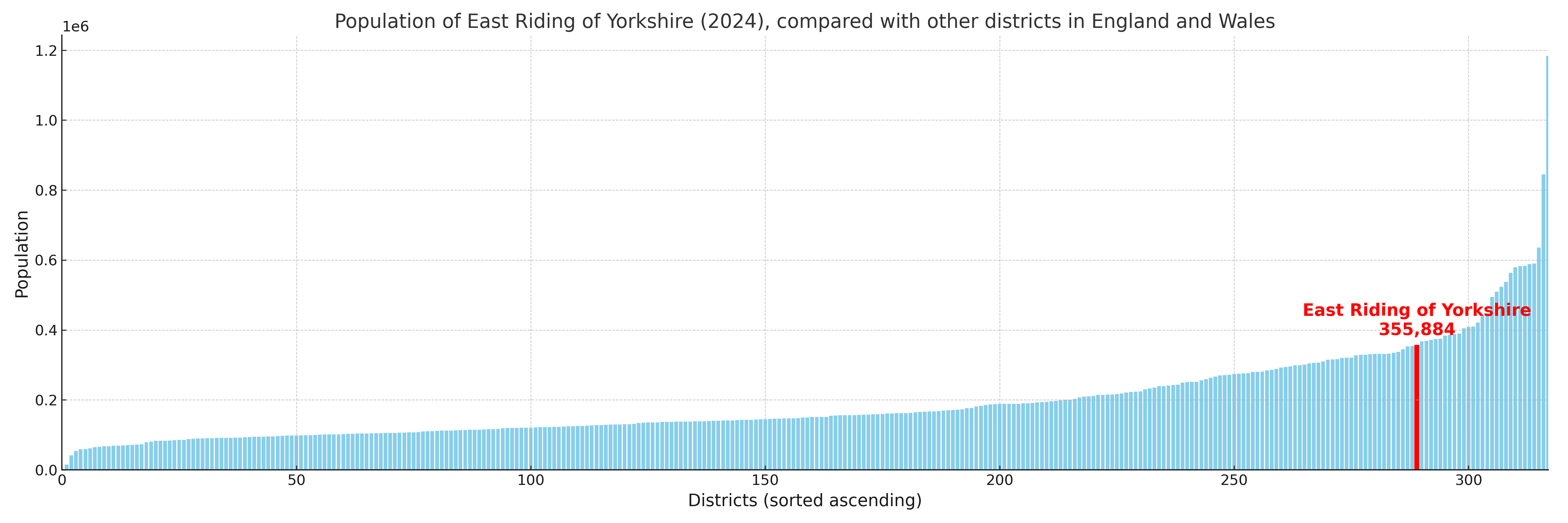
East Riding of Yorkshire compared with other districts in the UK
This section shows how East Riding of Yorkshire compares with other local authority districts in the UK, using a variety of measures and rankings.
East Riding of Yorkshire has 26 electoral wards.

East Riding of Yorkshire has a population of 355,884 (2024 mid-year estimate by ONS)
Population and Migration Trends in East Riding of Yorkshire
This chart shows the population trend for East Riding of Yorkshire from 2015 to 2024. It provides a quick overview of whether the local authority is growing, stable, or declining over time, and helps set context for the migration patterns shown below.
Population change is influenced by natural change (births minus deaths) and migration. The net migration chart below focuses on migration, separating internal migration (moves within the UK) from international migration (moves to and from abroad). Positive values indicate net inflows, while negative values indicate net outflows. The rate labels (per 1,000 residents) help compare migration intensity across years, even when the population size changes.
More local statistics and data for East Riding of Yorkshire can be found on the ONS statistics for East Riding of Yorkshire.
Latest news about East Riding of Yorkshire
Use the search box, or suggested search phrases, below to find recent news, council updates, planning stories, housing developments, transport changes, public services news, local elections, community issues and other local developments related to East Riding of Yorkshire. Results may include coverage from UK national, regional and local news websites, as well as official public-sector and local democracy sources.
- East Riding of Yorkshire council
- East Riding of Yorkshire planning
- East Riding of Yorkshire local elections
- East Riding of Yorkshire housing
- East Riding of Yorkshire transport
- East Riding of Yorkshire regeneration
- East Riding of Yorkshire public services