Barnsley
§ This page gives an overview of the Barnsley local authority district, bringing together key facts, maps, and data to help you quickly understand the area. This is one of 361 LAD profiles on Baseview.
Overview ⁞ Barnsley sits between the Peak District National Park to the west and the rolling South Yorkshire landscape to the east. The town of Barnsley is historically linked with coal mining and glassmaking, and today it retains a proud industrial heritage while offering modern shopping, culture, and markets. Surrounding areas include picturesque villages, Cannon Hall Museum and Gardens, and Wentworth Castle Gardens. Its location near the Pennines provides outdoor opportunities, while its heritage is celebrated in museums and cultural festivals.
Barnsley Boundary Map
This map shows the official boundary of the Barnsley local authority district, based on the latest geographic data published by the Office for National Statistics (ONS). It provides a clear view of the district’s extent and helps you understand how the area fits within the wider regional and national landscape.
Contains OS data © Crown copyright and database right 2025. Source: Office for National Statistics licensed under the Open Government Licence v3.0.
The administrative boundary of Barnsley can also be viewed on OpenStreetMap: District Boundary of Barnsley.
Key Facts about Barnsley
What region is Barnsley in? Barnsley is in the Yorkshire and The Humber of England, a region within the UK.
What county is Barnsley in? Barnsley is located in the county of South Yorkshire.
Is Barnsley a city? No, Barnsley is not a city. (Note: the UK has 76 officially designated cities.)
Who governs Barnsley? The local government for this district is: Barnsley Borough Council (Metropolitan District).
▶ Official website of Barnsley Borough Council 🔗 barnsley.gov.uk
Which police force covers Barnsley? Policing in Barnsley is provided by South Yorkshire Police 🔗 southyorkshire.police.uk, which serves 4 local authority districts: Barnsley ⁞ Doncaster ⁞ Rotherham ⁞ Sheffield.
Barnsley in International Geographies
In the International Territorial Levels (ITLs) hierarchy, Barnsley is an ITLs Level 3 area:
- (ITL 1) Yorkshire and The Humber
- (ITL 2) ⇒ South Yorkshire
- (ITL 3) ⇒⇒ Barnsley
The International Territorial Levels are used by OECD member countries for statistical purposes to classify administrative areas. We have this listable page for easy browsing of ITL names and codes: International Territorial Levels.
Constituencies in Barnsley
Barnsley is divided into 3 parliamentary constituencies, listed below in alphabetical order.
A constituency is a specific geographical area that elects one Member of Parliament (MP) to represent them in the House of Commons. The United Kingdom is divided into 650 parliamentary constituencies, 54 of them are in Yorkshire and the Humber region. We have this list page for easy browsing of all UK parliamentary constituencies: List of Constituencies.
Wards in Barnsley
Barnsley is divided into 21 wards, listed below in alphabetical order.
- Central
- Cudworth
- Darfield
- Darton East
- Darton West
- Dearne North
- Dearne South
- Dodworth
- Hoyland Milton
- Kingstone
- Monk Bretton
- North East
- Old Town
- Penistone East
- Penistone West
- Rockingham
- Royston
- St Helens
- Stairfoot
- Wombwell
- Worsbrough
In the UK, a ward is a subdivision of a local authority area, used mainly for electoral and statistical purposes. Defined by the ONS, wards represent the primary unit for local elections, each returning one or more councillors to the local council. Wards are also used as a key geography for presenting population and census data. We have this list page for easy browsing of all electoral wards: List of all Electoral Wards in the UK.
Parishes in Barnsley
Barnsley is part-parished: 17 civil parishes (listed A-Z below) alongside 4 unparished areas.
- Billingley
- Cawthorne
- Dunford
- Great Houghton
- Gunthwaite and Ingbirchworth
- High Hoyland
- Hunshelf
- Langsett
- Little Houghton
- Oxspring
- Penistone
- Shafton
- Silkstone
- Stainborough
- Tankersley
- Thurgoland
- Wortley
A civil parish is the lowest tier of local government in England, used for villages, small towns, and suburbs. They have their own local authority, either a parish council or a parish meeting, which provides local services like managing parks, allotments, and streetlights, and represents the community's views to larger councils.
We have this list page for easy browsing of all parishes: List of Civil Parishes in England and Wales.
Post Towns in Barnsley
Below is a list of post towns in Barnsley, grouped by postcode area:
S ▸ Barnsley (S70 / S71 / S72 / S73 / S74 / S75)
The UK postal hierarchy begins with broad postcode areas (such as “CB” or “M”), which are divided into smaller postcode districts (such as “CB8” or “M1”) to support accurate mail routing. Each postal address is anchored by a designated post town, the official locality name used in the UK postcode system, which operates independently from Local Authority Districts —the administrative boundaries used for council tax and local government services. Because they serve different purposes, a property’s postal address and its local authority district do not always align exactly.
Built-up Areas in Barnsley
Barnsley covers 40 built-up areas, listed below in alphabetical order.
- Barnburgh and Harlington *
- Barnsley
- Barugh Green and Redbrook
- Birdwell
- Bolton upon Dearne *
- Brampton (Rotherham) *
- Brierley
- Carlton (Barnsley)
- Cawthorne
- Chapeltown and High Green *
- Crow Edge
- Cudworth and Shafton
- Darfield
- Darton *
- Dodworth
- Goldthorpe *
- Great Houghton (Barnsley)
- Grimethorpe
- Hemingfield
- Hoyland
- Hoylandswaine
- Ingbirchworth *
- Jump
- Millhouse Green
- Oughtibridge *
- Oxspring
- Penistone
- Royston (Barnsley) *
- Silkstone
- Silkstone Common
- Thurgoland
- Thurlstone
- Thurnscoe *
- Upper Denby *
- Upper Hoyland
- Upper Tankersley
- Wath upon Dearne *
- Wharncliffe Side *
- Wombwell *
- Worsbrough
In the UK, a Built-up Area (BUA) is a continuous urban area of at least 20 hectares (0.2 km²), defined by the ONS as land where buildings are generally no more than 200 metres apart, such as towns, cities, or large villages. (Note: A BUA name marked with an asterisk (*) indicates that the area is situated partly in the district of Barnsley.)
We have this list page for easy browsing of all built-up areas: List of all Built-up Areas in GB.
Railway Stations in Barnsley
Barnsley is served by a number of National Rail stations, providing rail connections to nearby towns, cities, and destinations across Great Britain. The railway stations listed below are located within the Barnsley Local Authority District and are grouped by train operating company for clarity.
- Northern Trains ▸ Barnsley (S71 1BP) ⁞ Wombwell (S73 0LU) ⁞ Elsecar (S74 8BD) ⁞ Penistone (S36 6HL) ⁞ Darton (S75 5HX) ⁞ Thurnscoe (S63 0JR) ⁞ Bolton-Upon-Dearne (S63 8NY) ⁞ Goldthorpe (S63 9BS) ⁞ Dodworth (S75 3JX) ⁞ Silkstone Common (S75 4RS)
This is a district-level view only. For a complete list of all National Rail stations across Great Britain, see the UK National Rail Stations Directory.
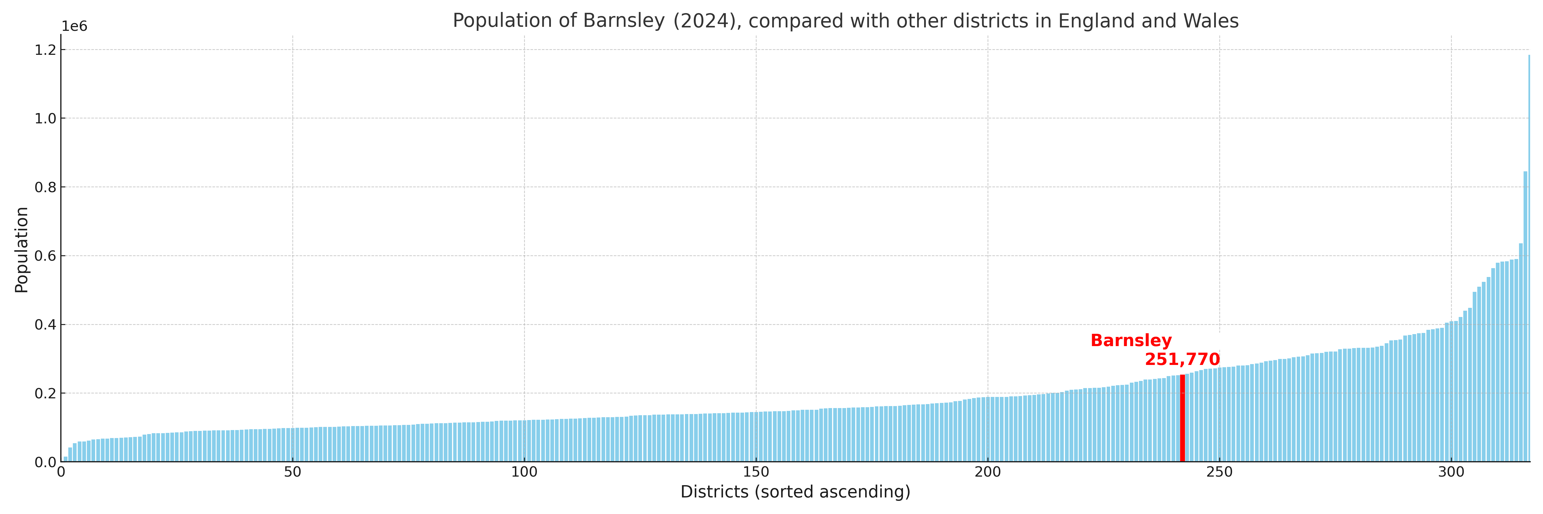
Barnsley compared with other districts in the UK
This section shows how Barnsley compares with other local authority districts in the UK, using a variety of measures and rankings.
Barnsley has 21 electoral wards.

Barnsley has a population of 251,770 (2024 mid-year estimate by ONS)
Population and Migration Trends in Barnsley
This chart shows the population trend for Barnsley from 2015 to 2024. It provides a quick overview of whether the local authority is growing, stable, or declining over time, and helps set context for the migration patterns shown below.
Population change is influenced by natural change (births minus deaths) and migration. The net migration chart below focuses on migration, separating internal migration (moves within the UK) from international migration (moves to and from abroad). Positive values indicate net inflows, while negative values indicate net outflows. The rate labels (per 1,000 residents) help compare migration intensity across years, even when the population size changes.
More local statistics and data for Barnsley can be found on the ONS statistics for Barnsley.
Latest news about Barnsley
Use the search box, or suggested search phrases, below to find recent news, council updates, planning stories, housing developments, transport changes, public services news, local elections, community issues and other local developments related to Barnsley. Results may include coverage from UK national, regional and local news websites, as well as official public-sector and local democracy sources.
- Barnsley council
- Barnsley planning
- Barnsley local elections
- Barnsley housing
- Barnsley transport
- Barnsley regeneration
- Barnsley public services