Rotherham
§ This page gives an overview of the Rotherham local authority district, bringing together key facts, maps, and data to help you quickly understand the area. This is one of 361 LAD profiles on Baseview.
Overview ⁞ Rotherham lies along the River Don and is closely tied to Sheffield, with a strong industrial past in steel and coal. The town is home to Rotherham Minster, Clifton Park and Museum, and Magna Science Adventure Centre, housed in a former steelworks. Surrounding areas include Wentworth Woodhouse, one of the largest stately homes in Europe, and the beautiful countryside of the Rother Valley Country Park. Historic villages and rolling farmland provide contrast to the urban areas, making Rotherham a place of both heritage and natural appeal.
Rotherham Boundary Map
This map shows the official boundary of the Rotherham local authority district, based on the latest geographic data published by the Office for National Statistics (ONS). It provides a clear view of the district’s extent and helps you understand how the area fits within the wider regional and national landscape.
Contains OS data © Crown copyright and database right 2025. Source: Office for National Statistics licensed under the Open Government Licence v3.0.
The administrative boundary of Rotherham can also be viewed on OpenStreetMap: District Boundary of Rotherham.
Key Facts about Rotherham
What region is Rotherham in? Rotherham is in the Yorkshire and The Humber of England, a region within the UK.
What county is Rotherham in? Rotherham is located in the county of South Yorkshire.
Is Rotherham a city? No, Rotherham is not a city. (Note: the UK has 76 officially designated cities.)
Who governs Rotherham? The local government for this district is: Rotherham Borough Council (Metropolitan District).
▶ Official website of Rotherham Borough Council 🔗 rotherham.gov.uk
Which police force covers Rotherham? Policing in Rotherham is provided by South Yorkshire Police 🔗 southyorkshire.police.uk, which serves 4 local authority districts: Barnsley ⁞ Doncaster ⁞ Rotherham ⁞ Sheffield.
Rotherham in International Geographies
In the International Territorial Levels (ITLs) hierarchy, Rotherham is an ITLs Level 3 area:
- (ITL 1) Yorkshire and The Humber
- (ITL 2) ⇒ South Yorkshire
- (ITL 3) ⇒⇒ Rotherham
The International Territorial Levels are used by OECD member countries for statistical purposes to classify administrative areas. We have this listable page for easy browsing of ITL names and codes: International Territorial Levels.
Constituencies in Rotherham
Rotherham is divided into 3 parliamentary constituencies, listed below in alphabetical order.
A constituency is a specific geographical area that elects one Member of Parliament (MP) to represent them in the House of Commons. The United Kingdom is divided into 650 parliamentary constituencies, 54 of them are in Yorkshire and the Humber region. We have this list page for easy browsing of all UK parliamentary constituencies: List of Constituencies.
Wards in Rotherham
Rotherham is divided into 25 wards, listed below in alphabetical order.
- Anston & Woodsetts
- Aston & Todwick
- Aughton & Swallownest
- Boston Castle
- Bramley & Ravenfield
- Brinsworth
- Dalton & Thrybergh
- Dinnington
- Greasbrough
- Hellaby & Maltby West
- Hoober
- Keppel
- Kilnhurst & Swinton East
- Maltby East
- Rawmarsh East
- Rawmarsh West
- Rother Vale
- Rotherham East
- Rotherham West
- Sitwell
- Swinton Rockingham
- Thurcroft & Wickersley South
- Wales
- Wath
- Wickersley North
In the UK, a ward is a subdivision of a local authority area, used mainly for electoral and statistical purposes. Defined by the ONS, wards represent the primary unit for local elections, each returning one or more councillors to the local council. Wards are also used as a key geography for presenting population and census data. We have this list page for easy browsing of all electoral wards: List of all Electoral Wards in the UK.
Parishes in Rotherham
Rotherham is part-parished: 31 civil parishes (listed A-Z below) alongside 3 unparished areas.
- Aston cum Aughton
- Bramley
- Brampton Bierlow
- Brinsworth
- Catcliffe
- Dalton
- Dinnington St. John's
- Firbeck
- Gildingwells
- Harthill with Woodall
- Hellaby
- Hooton Levitt
- Hooton Roberts
- Laughton-en-le-Morthen
- Letwell
- Maltby
- North and South Anston
- Orgreave
- Ravenfield
- Thorpe Salvin
- Thrybergh
- Thurcroft
- Todwick
- Treeton
- Ulley
- Wales
- Waverley
- Wentworth
- Whiston
- Wickersley
- Woodsetts
A civil parish is the lowest tier of local government in England, used for villages, small towns, and suburbs. They have their own local authority, either a parish council or a parish meeting, which provides local services like managing parks, allotments, and streetlights, and represents the community's views to larger councils.
We have this list page for easy browsing of all parishes: List of Civil Parishes in England and Wales.
Post Towns in Rotherham
Below is a list of post towns in Rotherham, grouped by postcode area:
S ▸ Rotherham (S60 / S61 / S62 / S63 / S65 / S66 / S97)
The UK postal hierarchy begins with broad postcode areas (such as “CB” or “M”), which are divided into smaller postcode districts (such as “CB8” or “M1”) to support accurate mail routing. Each postal address is anchored by a designated post town, the official locality name used in the UK postcode system, which operates independently from Local Authority Districts —the administrative boundaries used for council tax and local government services. Because they serve different purposes, a property’s postal address and its local authority district do not always align exactly.
Built-up Areas in Rotherham
Rotherham covers 35 built-up areas, listed below in alphabetical order.
- Bolton upon Dearne *
- Brampton (Rotherham) *
- Brinsworth *
- Conisbrough *
- Dinnington (Rotherham)
- Greasbrough
- Harthill (Rotherham)
- Hellaby *
- Killamarsh *
- Kiveton Park
- Langold *
- Laughton en le Morthen
- Maltby *
- Mexborough *
- North Anston
- Rawmarsh
- Rotherham *
- Sheffield *
- Shireoaks *
- South Anston
- Swallownest and Aston
- Swinton (Rotherham) *
- Thorpe Hesley *
- Thorpe Salvin
- Thrybergh and Dalton
- Thurcroft
- Todwick
- Treeton
- Wath upon Dearne *
- Waverley and Catcliffe
- Wentworth (Rotherham)
- Whiston
- Wickersley and Bramley
- Wombwell *
- Woodsetts
In the UK, a Built-up Area (BUA) is a continuous urban area of at least 20 hectares (0.2 km²), defined by the ONS as land where buildings are generally no more than 200 metres apart, such as towns, cities, or large villages. (Note: A BUA name marked with an asterisk (*) indicates that the area is situated partly in the district of Rotherham.)
We have this list page for easy browsing of all built-up areas: List of all Built-up Areas in GB.
Railway Stations in Rotherham
Rotherham is served by a number of National Rail stations, providing rail connections to nearby towns, cities, and destinations across Great Britain. The railway stations listed below are located within the Rotherham Local Authority District and are grouped by train operating company for clarity.
- Northern Trains ▸ Rotherham Central (S60 1QH) ⁞ Swinton (South Yorks) (S64 8SP) ⁞ Kiveton Bridge (S26 8QP) ⁞ Kiveton Park (S26 6PB)
This is a district-level view only. For a complete list of all National Rail stations across Great Britain, see the UK National Rail Stations Directory.
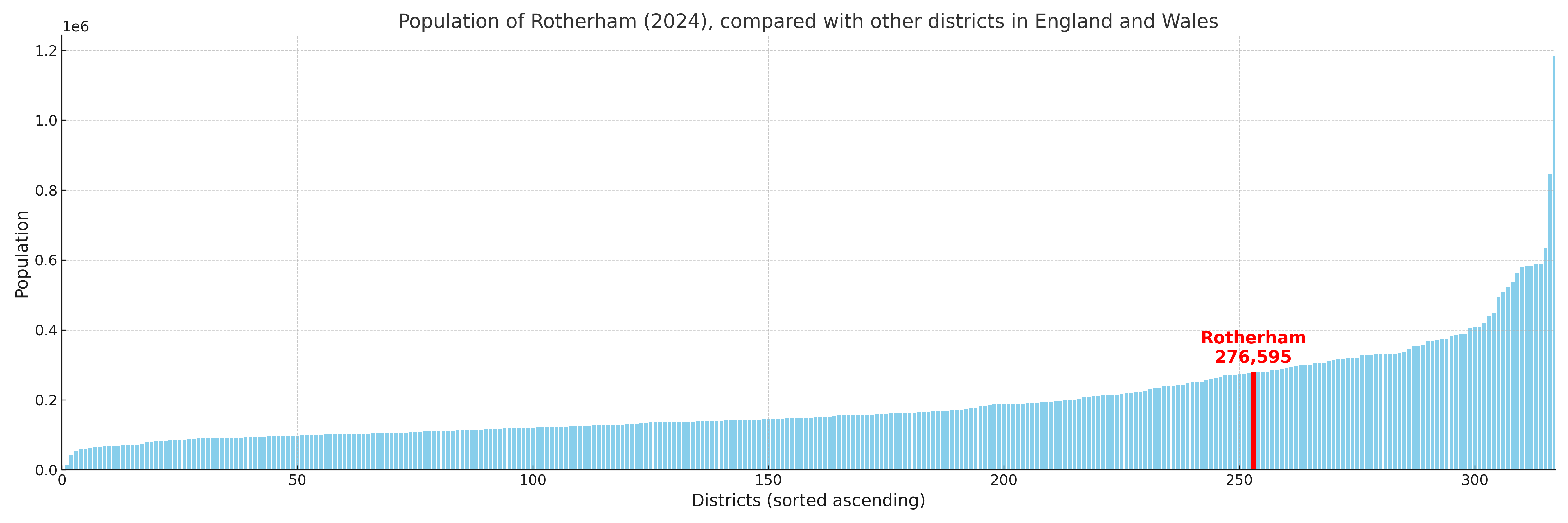
Rotherham compared with other districts in the UK
This section shows how Rotherham compares with other local authority districts in the UK, using a variety of measures and rankings.
Rotherham has 25 electoral wards.

Rotherham has a population of 276,595 (2024 mid-year estimate by ONS)
Population and Migration Trends in Rotherham
This chart shows the population trend for Rotherham from 2015 to 2024. It provides a quick overview of whether the local authority is growing, stable, or declining over time, and helps set context for the migration patterns shown below.
Population change is influenced by natural change (births minus deaths) and migration. The net migration chart below focuses on migration, separating internal migration (moves within the UK) from international migration (moves to and from abroad). Positive values indicate net inflows, while negative values indicate net outflows. The rate labels (per 1,000 residents) help compare migration intensity across years, even when the population size changes.
More local statistics and data for Rotherham can be found on the ONS statistics for Rotherham.
Latest news about Rotherham
Use the search box, or suggested search phrases, below to find recent news, council updates, planning stories, housing developments, transport changes, public services news, local elections, community issues and other local developments related to Rotherham. Results may include coverage from UK national, regional and local news websites, as well as official public-sector and local democracy sources.
- Rotherham council
- Rotherham planning
- Rotherham local elections
- Rotherham housing
- Rotherham transport
- Rotherham regeneration
- Rotherham public services