North Yorkshire
§ This page gives an overview of the North Yorkshire local authority district, bringing together key facts, maps, and data to help you quickly understand the area. This is one of 361 LAD profiles on Baseview.
Overview ⁞ North Yorkshire is England’s largest county district, covering vast areas of countryside, coastline, and historic towns. It is home to two national parks: the Yorkshire Dales, with its limestone cliffs, valleys, and villages like Grassington and Hawes, and the North York Moors, with heather moorlands, forests, and dramatic coastal scenery around Whitby and Robin Hood’s Bay. Market towns such as Harrogate, Ripon, and Northallerton combine Georgian and Victorian architecture with bustling centres, while Scarborough and Filey are traditional seaside resorts. The district also features Fountains Abbey, a UNESCO World Heritage Site, Castle Howard, and the rolling Howardian Hills. Its landscapes range from rugged uplands to fertile plains, framed by rivers, dales, and a striking eastern coastline.
North Yorkshire Boundary Map
This map shows the official boundary of the North Yorkshire local authority district, based on the latest geographic data published by the Office for National Statistics (ONS). It provides a clear view of the district’s extent and helps you understand how the area fits within the wider regional and national landscape.
Contains OS data © Crown copyright and database right 2025. Source: Office for National Statistics licensed under the Open Government Licence v3.0.
The administrative boundary of North Yorkshire can also be viewed on OpenStreetMap: District Boundary of North Yorkshire.
Key Facts about North Yorkshire
What region is North Yorkshire in? North Yorkshire is in the Yorkshire and The Humber of England, a region within the UK.
What county is North Yorkshire in? North Yorkshire is in the county of North Yorkshire.
Is North Yorkshire a city? Yes, North Yorkshire is a city. North Yorkshire holds official city status as one of the 76 designated cities in the UK.
Who governs North Yorkshire? The local government for this district is: North Yorkshire Council (Unitary Authority).
▶ Official website of North Yorkshire Council 🔗 northyorks.gov.uk
Which police force covers North Yorkshire? Policing in North Yorkshire is provided by North Yorkshire Police 🔗 northyorkshire.police.uk, which serves 2 local authority districts: North Yorkshire ⁞ York.
North Yorkshire in International Geographies
In the International Territorial Levels (ITLs) hierarchy, North Yorkshire is one of ITLs Level 2 area that contains the following 2 ITLs Level 3 areas:
(ITL 1) Yorkshire and The Humber
(ITL 2) ⇒ North Yorkshire
(ITL 3) ⇒⇒ York ⁞ North Yorkshire
The International Territorial Levels are used by OECD member countries for statistical purposes to classify administrative areas. We have this listable page for easy browsing of ITL names and codes: International Territorial Levels.
Constituencies in North Yorkshire
North Yorkshire is divided into 7 parliamentary constituencies, listed below in alphabetical order.
- Harrogate and Knaresborough
- Richmond and Northallerton
- Scarborough and Whitby
- Selby
- Skipton and Ripon
- Thirsk and Malton
- Wetherby and Easingwold
A constituency is a specific geographical area that elects one Member of Parliament (MP) to represent them in the House of Commons. The United Kingdom is divided into 650 parliamentary constituencies, 54 of them are in Yorkshire and the Humber region. We have this list page for easy browsing of all UK parliamentary constituencies: List of Constituencies.
Wards in North Yorkshire
North Yorkshire is divided into 89 wards, listed below in alphabetical order.
- Aire Valley
- Aiskew & Leeming
- Amotherby & Ampleforth
- Appleton Roebuck & Church Fenton
- Barlby & Riccall
- Bedale
- Bentham & Ingleton
- Bilton & Nidd Gorge
- Bilton Grange & New Park
- Boroughbridge & Claro
- Brayton & Barlow
- Camblesforth & Carlton
- Castle
- Catterick Village & Brompton-on-Swale
- Cawood & Escrick
- Cayton
- Cliffe & North Duffield
- Coppice Valley & Duchy
- Danby & Mulgrave
- Derwent Valley & Moor
- Easingwold
- Eastfield
- Esk Valley & Coast
- Fairfax & Starbeck
- Falsgrave & Stepney
- Filey
- Glusburn, Cross Hills & Sutton-in-Craven
- Great Ayton
- Harlow & St. Georges
- Helmsley & Sinnington
- High Harrogate & Kingsley
- Hillside & Raskelf
- Hipswell & Colburn
- Huby & Tollerton
- Hunmanby & Sherburn
- Hutton Rudby & Osmotherley
- Killinghall, Hampsthwaite & Saltergate
- Kirkbymoorside & Dales
- Knaresborough East
- Knaresborough West
- Leyburn & Middleham
- Malton
- Masham & Fountains
- Mid Craven
- Monk Fryston & South Milford
- Morton-on-Swale & Appleton Wiske
- Newby
- North Richmondshire
- Northallerton North & Brompton
- Northallerton South
- Northstead
- Norton
- Oatlands & Pannal
- Osgoldcross
- Ouseburn
- Pateley Bridge & Nidderdale
- Pickering
- Richmond
- Ripon Minster & Moorside
- Ripon Ure Bank & Spa
- Romanby
- Scalby & the Coast
- Scotton & Lower Wensleydale
- Seamer
- Selby East
- Selby West
- Settle & Penyghent
- Sherburn in Elmet
- Sheriff Hutton & Derwent
- Skipton East & South
- Skipton North & Embsay-with-Eastby
- Skipton West & West Craven
- Sowerby & Topcliffe
- Spofforth with Lower Wharfedale & Tockwith
- Stokesley
- Stray, Woodlands & Hookstone
- Tadcaster
- Thirsk
- Thornton Dale & Wolds
- Thorpe Willoughby & Hambleton
- Upper Dales
- Valley Gardens & Central Harrogate
- Washburn & Birstwith
- Wathvale & Bishop Monkton
- Weaponness & Ramshill
- Wharfedale
- Whitby Streonshalh
- Whitby West
- Woodlands
In the UK, a ward is a subdivision of a local authority area, used mainly for electoral and statistical purposes. Defined by the ONS, wards represent the primary unit for local elections, each returning one or more councillors to the local council. Wards are also used as a key geography for presenting population and census data. We have this list page for easy browsing of all electoral wards: List of all Electoral Wards in the UK.
Parishes in North Yorkshire
North Yorkshire is part-parished: 711 civil parishes (listed A-Z below) alongside 5 unparished areas.
- Acaster Selby
- Acklam
- Ainderby Miers with Holtby
- Ainderby Quernhow
- Ainderby Steeple
- Airton
- Aiskew and Leeming Bar
- Aislaby
- Akebar
- Aldbrough
- Aldfield
- Aldwark
- Allerston
- Allerton Mauleverer with Hopperton
- Alne
- Amotherby
- Ampleforth
- Angram Grange
- Appleton East and West
- Appleton Roebuck
- Appleton Wiske
- Appleton-le-Moors
- Appleton-le-Street with Easthorpe
- Appletreewick
- Arkendale
- Arkengarthdale
- Arncliffe
- Arrathorne
- Asenby
- Aske
- Askrigg
- Askwith
- Austwick
- Aysgarth
- Azerley
- Bagby
- Bainbridge
- Baldersby
- Balk
- Balne
- Bank Newton
- Barden
- Barkston Ash
- Barlby with Osgodby
- Barlow
- Barnby
- Barton
- Barton-le-Street
- Barton-le-Willows
- Barugh (Great and Little)
- Beadlam
- Beal
- Beamsley
- Beckwithshaw
- Bedale
- Bellerby
- Beningbrough
- Bentham
- Bewerley
- Biggin
- Bilbrough
- Bilsdale Midcable
- Bilton-in-Ainsty with Bickerton
- Birdforth
- Birdsall
- Birkby
- Birkin
- Birstwith
- Bishop Monkton
- Bishop Thornton, Shaw Mills and Warsill
- Bishopdale
- Blubberhouses
- Boltby
- Bolton Abbey
- Bolton Percy
- Bolton-on-Swale
- Boroughbridge
- Borrowby
- Bradleys Both
- Brafferton and Helperby
- Brandsby-cum-Stearsby
- Bransdale
- Brawby
- Brayton
- Brearton
- Bridge Hewick
- Brompton
- Brompton-on-Swale
- Brotherton
- Brough with St. Giles
- Broughton
- Broxa-cum-Troutsdale
- Buckden
- Bulmer
- Burn
- Burneston
- Burniston
- Burnsall
- Burrill with Cowling
- Burton in Lonsdale
- Burton Leonard
- Burton Salmon
- Burton-cum-Walden
- Burton-on-Yore
- Burythorpe
- Buttercrambe with Bossall
- Byland with Wass
- Byram cum Sutton
- Caldbergh with East Scrafton
- Caldwell
- Calton
- Camblesforth
- Carkin
- Carleton
- Carlton
- Carlton Highdale
- Carlton Husthwaite
- Carlton Miniott
- Carlton Town
- Carperby-cum-Thoresby
- Carthorpe
- Castle Bolton with East and West Bolton
- Castley
- Cattal
- Catterick
- Catterton
- Catton
- Cawood
- Cawton
- Cayton
- Chapel Haddlesey
- Church Fenton
- Clapham cum Newby
- Claxton
- Cleasby
- Cliffe
- Clifton-on-Yore
- Clint cum Hamlets
- Cloughton
- Colburn
- Cold Kirby
- Colsterdale
- Colton
- Commondale
- Coneysthorpe
- Coneythorpe and Clareton
- Coniston Cold
- Conistone with Kilnsey
- Cononley
- Constable Burton
- Copgrove
- Copt Hewick
- Cotcliffe
- Coulton
- Coverham with Agglethorpe
- Cowesby
- Cowling
- Coxwold
- Cracoe
- Crakehall
- Crambe
- Crathorne
- Crayke
- Cridling Stubbs
- Croft-on-Tees
- Cropton
- Crosby
- Cundall with Leckby
- Dacre
- Dalby-cum-Skewsby
- Dalton
- Dalton-on-Tees
- Danby
- Danby Wiske with Lazenby
- Darley and Menwith
- Darncombe-cum-Langdale End
- Deighton
- Denton
- Dishforth
- Downholme
- Draughton
- Drax
- Dunsforths
- Easby
- Easingwold
- East Ayton
- East Cowton
- East Harlsey
- East Hauxwell
- East Layton
- East Rounton
- East Tanfield
- East Witton
- Eastfield
- Eavestone
- Ebberston and Yedingham
- Edstone
- Eggborough
- Egton
- Eldmire with Crakehill
- Ellenthorpe
- Ellerbeck
- Ellerby
- Ellerton Abbey
- Ellerton-on-Swale
- Ellingstring
- Ellington High and Low
- Elslack
- Embsay with Eastby
- Eppleby
- Eryholme
- Escrick
- Eshton
- Eskdaleside cum Ugglebarnby
- Exelby, Leeming and Londonderry
- Faceby
- Fadmoor
- Fairburn
- Farlington
- Farndale East
- Farndale West
- Farnham
- Farnhill
- Farnley
- Fawdington
- Fearby
- Felixkirk
- Felliscliffe
- Ferrensby
- Fewston
- Filey
- Finghall
- Firby
- Flasby with Winterburn
- Flawith
- Flaxby
- Flaxton
- Folkton
- Follifoot
- Forcett
- Foston
- Fountains Earth
- Foxholes
- Fryton
- Fylingdales
- Ganton
- Gargrave
- Garriston
- Gate Helmsley
- Gateforth
- Gatenby
- Gayles
- Giggleswick
- Gillamoor
- Gilling East
- Gilling with Hartforth and Sedbury
- Girsby
- Givendale
- Glaisdale
- Glusburn and Cross Hills
- Goathland
- Goldsborough
- Grantley
- Grassington
- Great and Little Broughton
- Great Ayton
- Great Busby
- Great Langton
- Great Ouseburn
- Great Ribston with Walshford
- Great Smeaton
- Great Timble
- Green Hammerton
- Grewelthorpe
- Grimston
- Grimstone
- Grinton
- Gristhorpe
- Grosmont
- Habton
- Hackforth
- Hackness
- Halton East
- Halton Gill
- Halton West
- Hambleton
- Hampsthwaite
- Hanlith
- Harmby
- Harome
- Hartlington
- Hartoft
- Harton
- Hartwith cum Winsley
- Harwood Dale
- Haverah Park
- Hawes
- Hawkswick
- Hawnby
- Hawsker-cum-Stainsacre
- Hazlewood with Storiths
- Healaugh
- Healey
- Hebden
- Heck
- Hellifield
- Helmsley
- Hemingbrough
- Henderskelfe
- Hensall
- Heslerton
- Hetton-cum-Bordley
- High Abbotside
- High and Low Bishopside
- High Worsall
- Hillam
- Hinderwell
- Hipswell
- Hirst Courtney
- Holme
- Hood Grange
- Hornby
- Horton in Ribblesdale
- Hovingham
- Howe
- Howgrave
- Howsham
- Huby
- Huddleston with Newthorpe
- Hudswell
- Humberton
- Hunmanby
- Hunsingore
- Hunton
- Husthwaite
- Hutton Bonville
- Hutton Buscel
- Hutton Conyers
- Hutton Hang
- Hutton Mulgrave
- Hutton Rudby
- Hutton-le-Hole
- Hutton-Sessay
- Huttons Ambo
- Ilton-cum-Pott
- Ingleby Arncliffe
- Ingleby Greenhow
- Ingleton
- Irton
- Kearby with Netherby
- Kelfield
- Kellington
- Kepwick
- Kettlewell with Starbotton
- Kilburn High and Low
- Kildale
- Kildwick
- Killerby
- Killinghall
- Kiplin
- Kirby Grindalythe
- Kirby Hall
- Kirby Hill
- Kirby Knowle
- Kirby Misperton
- Kirby Sigston
- Kirby Wiske
- Kirk Deighton
- Kirk Hammerton
- Kirk Smeaton
- Kirkby
- Kirkby Fleetham with Fencote
- Kirkby Malham
- Kirkby Malzeard
- Kirkby Overblow
- Kirkby Wharfe with North Milford
- Kirkbymoorside
- Kirklington-cum-Upsland
- Knaresborough
- Knayton with Brawith
- Landmoth-cum-Catto
- Lands common to Fylingdales and Hawsker-cum-Stainsacre
- Langcliffe
- Langthorne
- Langthorpe
- Langton
- Lastingham
- Laverton
- Lawkland
- Lead
- Leake
- Leathley
- Leavening
- Lebberston
- Levisham
- Leyburn
- Lillings Ambo
- Lindley
- Lindrick with Studley Royal and Fountains
- Linton
- Linton-on-Ouse
- Little Ayton
- Little Busby
- Little Fenton
- Little Langton
- Little Ouseburn
- Little Ribston
- Little Smeaton
- Little Timble
- Littlethorpe
- Litton
- Lockton
- Long Drax
- Long Marston
- Long Preston
- Lothersdale
- Low Abbotside
- Low Worsall
- Luttons
- Lythe
- Malham
- Malham Moor
- Malton
- Manfield
- Marishes
- Markenfield Hall
- Markington with Wallerthwaite
- Marrick
- Marske
- Marton
- Marton cum Grafton
- Marton-cum-Moxby
- Marton-le-Moor
- Martons Both
- Masham
- Maunby
- Melbecks
- Melmerby
- Melsonby
- Mickleby
- Middleham
- Middleton
- Middleton Quernhow
- Middleton Tyas
- Middleton-on-Leven
- Milby
- Monk Fryston
- Moor Monkton
- Morton-on-Swale
- Moulton
- Muker
- Muston
- Myton-on-Swale
- Nawton
- Nesfield with Langbar
- Nether Silton
- New Forest
- Newall with Clifton
- Newbiggin
- Newburgh
- Newby
- Newby and Scalby
- Newby Wiske
- Newby with Mulwith
- Newholm-cum-Dunsley
- Newland
- Newsham
- Newsham with Breckenbrough
- Newton
- Newton Kyme cum Toulston
- Newton Morrell
- Newton Mulgrave
- Newton-le-Willows
- Newton-on-Ouse
- Nidd
- Normanby
- North Cowton
- North Deighton
- North Duffield
- North Kilvington
- North Otterington
- North Rigton
- North Stainley with Sleningford
- Northallerton
- Norton Conyers
- Norton-le-Clay
- Norton-on-Derwent
- Norwood
- Nun Monkton
- Nunnington
- Old Byland and Scawton
- Oldstead
- Osgodby
- Osmotherley
- Oswaldkirk
- Otterburn
- Oulston
- Over Dinsdale
- Over Silton
- Overton
- Oxton
- Pannal and Burn Bridge
- Patrick Brompton
- Pickering
- Pickhill with Roxby
- Picton
- Plompton
- Pockley
- Potto
- Preston-under-Scar
- Rainton with Newby
- Rand Grange
- Raskelf
- Rathmell
- Ravensworth
- Redmire
- Reeth, Fremington and Healaugh
- Reighton
- Riccall
- Richmond
- Rievaulx
- Rillington
- Ripley
- Ripon
- Roecliffe
- Romanby
- Rookwith
- Rosedale East Side
- Rosedale West Side
- Roxby
- Rudby
- Rylstone
- Ryther cum Ossendyke
- Salton
- Sand Hutton
- Sandhutton
- Sawley
- Saxton with Scarthingwell
- Scackleton
- Scagglethorpe
- Scampston
- Scorton
- Scosthrop
- Scotton
- Scrayingham
- Scriven
- Scruton
- Seamer
- Selby
- Sessay
- Settle
- Settrington
- Sexhow
- Sharow
- Sherburn
- Sherburn in Elmet
- Sheriff Hutton
- Shipton
- Sicklinghall
- Silpho
- Sinderby
- Sinnington
- Skeeby
- Skelding
- Skelton-on-Ure
- Skipton
- Skipton-on-Swale
- Skipwith
- Skutterskelfe
- Slingsby
- Snainton
- Snape with Thorp
- Sneaton
- South Cowton
- South Holme
- South Kilvington
- South Milford
- South Otterington
- South Stainley with Cayton
- Sowerby
- Sowerby-under-Cotcliffe
- Spaunton
- Spennithorne
- Spofforth with Stockeld
- Sproxton
- St. Martin's
- Stainburn
- Stainforth
- Stainton
- Staintondale
- Stanwick St. John
- Stape
- Stapleton
- Staveley
- Steeton
- Stillingfleet
- Stillington
- Stirton with Thorlby
- Stokesley
- Stonebeck Down
- Stonebeck Up
- Stonegrave
- Stubbs Walden
- Studley Roger
- Stutton with Hazlewood
- Suffield-cum-Everley
- Sutton
- Sutton with Howgrave
- Sutton-on-the-Forest
- Sutton-under-Whitestonecliffe
- Swainby with Allerthorpe
- Swinton
- Swinton with Warthermarske
- Tadcaster
- Temple Hirst
- Terrington
- Theakston
- Thimbleby
- Thirkleby High and Low with Osgodby
- Thirlby
- Thirn
- Thirsk
- Thixendale
- Tholthorpe
- Thoralby
- Thorganby
- Thormanby
- Thornbrough
- Thornthwaite with Padside
- Thornton Bridge
- Thornton in Craven
- Thornton in Lonsdale
- Thornton Rust
- Thornton Steward
- Thornton Watlass
- Thornton-le-Beans
- Thornton-le-Clay
- Thornton-le-Dale
- Thornton-le-Moor
- Thornton-le-Street
- Thornton-on-the-Hill
- Thornville
- Thorpe
- Thorpe Bassett
- Thorpe Underwoods
- Thorpe Willoughby
- Threshfield
- Thrintoft
- Thruscross
- Tockwith
- Tollerton
- Topcliffe
- Towton
- Tunstall
- Uckerby
- Ugthorpe
- Ulleskelf
- Upper Helmsley
- Upsall
- Walburn
- Walkingham Hill with Occaney
- Warlaby
- Warsill
- Warthill
- Wath
- Weaverthorpe
- Weeton
- Welburn (Kirkbymoorside & Dales Ward)
- Welburn (Sheriff Hutton & Derwent Ward)
- Welbury
- Well
- Wensley
- West Ayton
- West Haddlesey
- West Harlsey
- West Hauxwell
- West Layton
- West Rounton
- West Scrafton
- West Tanfield
- West Witton
- Westerdale
- Weston
- Westow
- Westwick
- Wharram
- Whashton
- Whenby
- Whitby
- Whitley
- Whitwell
- Whitwell-on-the-Hill
- Whixley
- Whorlton
- Wigglesworth
- Wighill
- Wildon Grange
- Willerby
- Wilstrop
- Wilton
- Winksley
- Winton, Stank and Hallikeld
- Wintringham
- Wistow
- Wombleton
- Womersley
- Wrelton
- Wykeham
- Yafforth
- Yearsley
- Youlton
A civil parish is the lowest tier of local government in England, used for villages, small towns, and suburbs. They have their own local authority, either a parish council or a parish meeting, which provides local services like managing parks, allotments, and streetlights, and represents the community's views to larger councils.
We have this list page for easy browsing of all parishes: List of Civil Parishes in England and Wales.
Post Towns in North Yorkshire
Below is a list of post towns in North Yorkshire, grouped by postcode area:
- BD ▸ Settle (BD24) ⁞ Skipton (BD23)
- DL ▸ Bedale (DL8) ⁞ Catterick Garrison (DL9) ⁞ Hawes (DL8) ⁞ Leyburn (DL8) ⁞ Northallerton (DL6 / DL7) ⁞ Richmond (DL10 / DL11)
- HG ▸ Harrogate (HG1 / HG2 / HG3) ⁞ Knaresborough (HG5) ⁞ Ripon (HG4)
- LS ▸ Tadcaster (LS24)
- YO ▸ Filey (YO14) ⁞ Malton (YO17) ⁞ Pickering (YO18) ⁞ Scarborough (YO11 / YO12 / YO13) ⁞ Selby (YO8) ⁞ Thirsk (YO7) ⁞ Whitby (YO21 / YO22)
The UK postal hierarchy begins with broad postcode areas (such as “CB” or “M”), which are divided into smaller postcode districts (such as “CB8” or “M1”) to support accurate mail routing. Each postal address is anchored by a designated post town, the official locality name used in the UK postcode system, which operates independently from Local Authority Districts —the administrative boundaries used for council tax and local government services. Because they serve different purposes, a property’s postal address and its local authority district do not always align exactly.
Built-up Areas in North Yorkshire
North Yorkshire covers 227 built-up areas, listed below in alphabetical order.
- Aberford *
- Addingham *
- Aiskew
- Alne
- Amotherby
- Ampleforth
- Appleton Roebuck
- Austwick
- Bagby
- Barkston Ash
- Barlby
- Barlow
- Barton (Richmondshire)
- Beal
- Bedale
- Bilbrough
- Birstwith
- Bishop Monkton
- Boroughbridge
- Borrowby
- Brayton
- Brompton
- Brompton-by-Sawdon
- Brompton-on-Swale
- Brotherton *
- Bubwith *
- Burley in Wharfedale *
- Burn
- Burniston
- Burton in Lonsdale
- Burton Leonard
- Byram
- Camblesforth
- Carleton-in-Craven
- Carlton (Selby)
- Carlton Miniott
- Carthorpe
- Castleton (Scarborough)
- Catterick
- Catterick Garrison
- Cawood
- Church Fenton
- Cliffe (Selby)
- Cloughton
- Cononley
- Cowling
- Cross Hills *
- Dalton
- Dalton-on-Tees
- Darley
- Darlington *
- Dishforth
- Drax
- Easingwold
- East Ayton and West Ayton
- East Cowton
- Ebberston
- Eggborough
- Embsay
- Escrick *
- Fairburn
- Farnhill
- Filey
- Firby
- Flaxton
- Flixton Ings
- Follifoot
- Fylingthorpe
- Gargrave
- Giggleswick
- Goathland
- Goldsborough
- Grassington
- Great Ayton
- Great Broughton
- Great Ouseburn
- Green Hammerton
- Grewelthorpe
- Gristhorpe
- Hambleton (Selby)
- Hampsthwaite
- Harmby
- Harrogate
- Hawes and Gayle
- Hellifield
- Helmsley
- Helperby and Brafferton
- Hemingbrough
- Hensall
- High Bentham
- Hinderwell
- Hirst Courtney
- Holmfield *
- Hovingham
- Huby (Hambleton)
- Huby (Harrogate)
- Hunmanby
- Hurworth-on-Tees *
- Husthwaite
- Hutton Buscel
- Hutton Rudby
- Ilkley *
- Ingleton
- Kellingley
- Kellington
- Killinghall
- Kirby Hill
- Kirby Misperton
- Kirk Smeaton and Little Smeaton *
- Kirkby Malzeard
- Kirkby Overblow
- Kirkbymoorside
- Knaresborough
- Knayton
- Langthorpe
- Leeming
- Leeming Bar
- Leyburn
- Linton-on-Ouse
- Long Marston (Harrogate)
- Long Preston
- Low Bentham
- Low Bradley
- Low Worsall
- Malton
- Masham
- Melmerby
- Melsonby
- Middleham
- Middleton (Ryedale)
- Middleton Tyas
- Monk Fryston and Hillam
- Morton-on-Swale
- Muston (Scarborough)
- Nawton and Beadlam
- Newton-on-Ouse
- North Duffield
- North Stainley
- Northallerton
- Norton-on-Derwent
- Osgodby (Selby)
- Osmotherley
- Oswaldkirk
- Otley (Leeds) *
- Pannal
- Pateley Bridge
- Pickering
- Pickhill
- Pool-in-Wharfedale *
- Primrose Valley
- Rainton
- Raskelf
- Reighton Sands
- Riccall
- Richmond
- Rillington
- Ripon
- Robin Hood's Bay
- Roecliffe
- Romanby
- Saxton
- Scalby
- Scarborough
- Scorton
- Scotton (Harrogate)
- Scruton
- Seamer (Hambleton)
- Seamer (Scarborough)
- Selby
- Settle
- Settrington
- Sharow
- Sherburn (Ryedale)
- Sherburn in Elmet
- Sheriff Hutton
- Shipton (Hambleton)
- Sinnington
- Skipton
- Sleights
- Slingsby
- Snainton
- Snape (Hambleton)
- Sneatonthorpe
- South Milford
- Sowerby
- Spofforth
- Staithes *
- Stamford Bridge *
- Staveley (Harrogate)
- Staxton
- Steeton *
- Stillingfleet
- Stillington (Hambleton)
- Stockton on the Forest *
- Stokesley
- Summerbridge
- Sutton-in-Craven
- Sutton-on-the-Forest
- Swainby
- Swinton (Ryedale)
- Tadcaster
- Terrington
- Thirsk
- Thornton-in-Craven
- Thornton-le-Dale
- Thornton-le-Moor
- Thorpe Underwood
- Thorpe Willoughby
- Thorpefield
- Threshfield
- Tockwith
- Tollerton (Hambleton)
- Topcliffe
- Ulleskelf
- Upper Poppleton *
- Warthill
- Weaverthorpe
- West Tanfield
- West Witton
- Wetherby *
- Whitby
- Whitley (Selby)
- Whixley
- Wistow (Selby)
- Wombleton
- Womersley
- Yarm *
In the UK, a Built-up Area (BUA) is a continuous urban area of at least 20 hectares (0.2 km²), defined by the ONS as land where buildings are generally no more than 200 metres apart, such as towns, cities, or large villages. (Note: A BUA name marked with an asterisk (*) indicates that the area is situated partly in the district of North Yorkshire.)
We have this list page for easy browsing of all built-up areas: List of all Built-up Areas in GB.
Railway Stations in North Yorkshire
North Yorkshire is served by a number of National Rail stations, providing rail connections to nearby towns, cities, and destinations across Great Britain. The railway stations listed below are located within the North Yorkshire Local Authority District and are grouped by train operating company for clarity.
- Northern Trains ▸ Harrogate (HG1 1TE) ⁞ Skipton (BD23 1RT) ⁞ Knaresborough (HG5 9AA) ⁞ Hornbeam Park (HG2 8QT) ⁞ Starbeck (HG2 7JA) ⁞ Pannal (HG3 1JN) ⁞ Cononley (BD20 8HY) ⁞ Filey (YO14 9PE) ⁞ Church Fenton (LS24 9RA) ⁞ Whitby (YO21 1YN) ⁞ Settle (BD24 9AA) ⁞ South Milford (LS25 6AA) ⁞ Sherburn-In-Elmet (LS25 6DY) ⁞ Cattal (YO5 8EB) ⁞ Hammerton (Y26 8DG) ⁞ Hellifield (BD23 4HN) ⁞ Bentham (LA2 7LF) ⁞ Gargrave (BD23 3NE) ⁞ Hunmanby (YO14 0LR) ⁞ Ribblehead (LA6 3AS) ⁞ Horton-In-Ribblesdale (BD24 0HH) ⁞ Glaisdale (YO21 2QL) ⁞ Long Preston (BD23 4NH) ⁞ Ulleskelf (LS24 9DJ) ⁞ Giggleswick (BD24 0EA) ⁞ Grosmont (YO22 5QE) ⁞ Great Ayton (TS9 6HR) ⁞ Egton (YO21 1UX) ⁞ Clapham (North Yorkshire) (LA2 8ES) ⁞ Danby (YO21 2JL) ⁞ Lealholm (YO21 2AG) ⁞ Sleights (YO22 5AA) ⁞ Castleton Moor (YO21 2EU) ⁞ Ruswarp (YO21 1NJ) ⁞ Battersby (TS9 6LT) ⁞ Commondale (YO21 2HN) ⁞ Kildale (YO21 2RT) ⁞ Whitley Bridge (DN14 0HH) ⁞ Hensall (DN14 0QN)
- TransPennine Express ▸ Scarborough (YO11 1TN) ⁞ Northallerton (DL7 8AN) ⁞ Selby (YO8 0NW) ⁞ Malton (YO17 9RD) ⁞ Thirsk (YO7 4LS) ⁞ Seamer (YO12 4LT)
This is a district-level view only. For a complete list of all National Rail stations across Great Britain, see the UK National Rail Stations Directory.
North Yorkshire compared with other districts in the UK
This section shows how North Yorkshire compares with other local authority districts in the UK, using a variety of measures and rankings.
North Yorkshire has 89 electoral wards.

North Yorkshire has a population of 635,270 (2024 mid-year estimate by ONS)
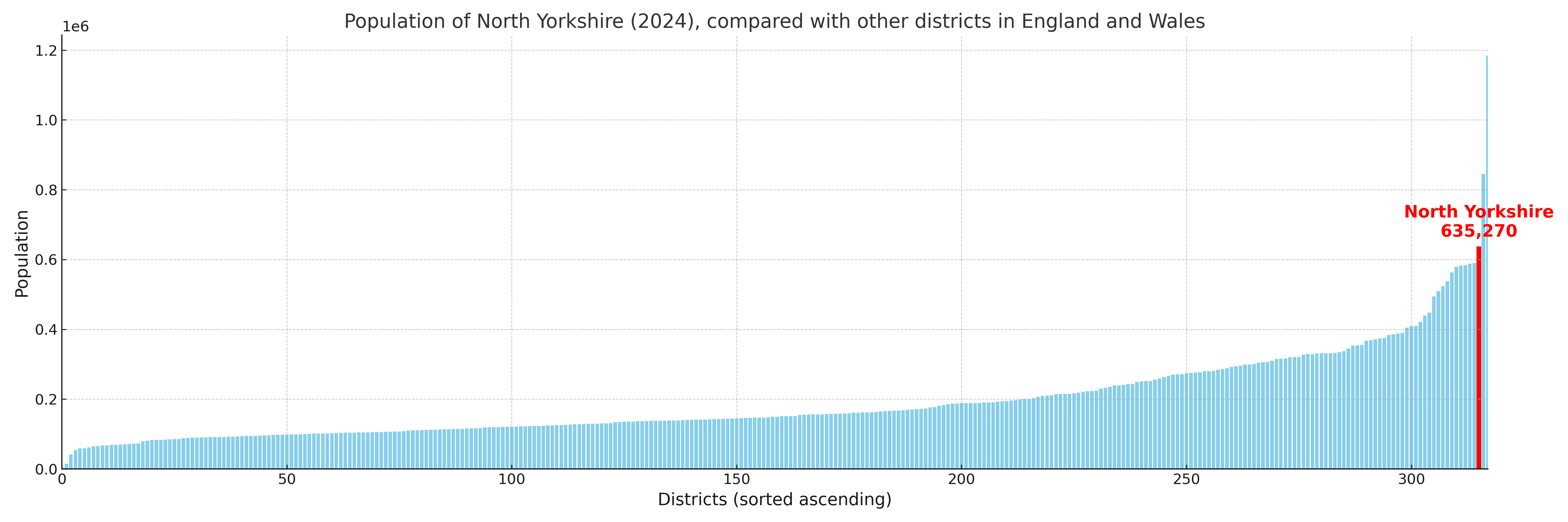
Population and Migration Trends in North Yorkshire
This chart shows the population trend for North Yorkshire from 2015 to 2024. It provides a quick overview of whether the local authority is growing, stable, or declining over time, and helps set context for the migration patterns shown below.
Population change is influenced by natural change (births minus deaths) and migration. The net migration chart below focuses on migration, separating internal migration (moves within the UK) from international migration (moves to and from abroad). Positive values indicate net inflows, while negative values indicate net outflows. The rate labels (per 1,000 residents) help compare migration intensity across years, even when the population size changes.
More local statistics and data for North Yorkshire can be found on the ONS statistics for North Yorkshire.
Latest news about North Yorkshire
Use the search box, or suggested search phrases, below to find recent news, council updates, planning stories, housing developments, transport changes, public services news, local elections, community issues and other local developments related to North Yorkshire. Results may include coverage from UK national, regional and local news websites, as well as official public-sector and local democracy sources.
- North Yorkshire council
- North Yorkshire planning
- North Yorkshire local elections
- North Yorkshire housing
- North Yorkshire transport
- North Yorkshire regeneration
- North Yorkshire public services