Wakefield
§ This page gives an overview of the Wakefield local authority district, bringing together key facts, maps, and data to help you quickly understand the area. This is one of 361 LAD profiles on Baseview.
Overview ⁞ Wakefield, on the River Calder, is a West Yorkshire city surrounded by market towns, villages, and countryside. The city itself features Wakefield Cathedral with its soaring spire, the Hepworth Wakefield art gallery, and historic markets. The district includes Pontefract, with its medieval castle and racecourse, and Castleford, known for its Roman history and riverside walks. The surrounding landscape includes rivers, canals, and former coalfield areas transformed into country parks and nature reserves, such as Anglers Country Park. Wakefield’s blend of historic towns, waterways, and green spaces creates a varied setting.
Wakefield Boundary Map
This map shows the official boundary of the Wakefield local authority district, based on the latest geographic data published by the Office for National Statistics (ONS). It provides a clear view of the district’s extent and helps you understand how the area fits within the wider regional and national landscape.
Contains OS data © Crown copyright and database right 2025. Source: Office for National Statistics licensed under the Open Government Licence v3.0.
The administrative boundary of Wakefield can also be viewed on OpenStreetMap: District Boundary of Wakefield.
Key Facts about Wakefield
What region is Wakefield in? Wakefield is in the Yorkshire and The Humber of England, a region within the UK.
What county is Wakefield in? Wakefield is located in the county of West Yorkshire.
Is Wakefield a city? Yes, Wakefield is a city. Wakefield holds official city status as one of the 76 designated cities in the UK.
Who governs Wakefield? The local government for this district is: Wakefield City Council (Metropolitan District).
▶ Official website of Wakefield City Council 🔗 wakefield.gov.uk
Which police force covers Wakefield? Policing in Wakefield is provided by West Yorkshire Police 🔗 westyorkshire.police.uk, which serves 5 local authority districts: Bradford ⁞ Calderdale ⁞ Kirklees ⁞ Leeds ⁞ Wakefield.
Wakefield in International Geographies
In the International Territorial Levels (ITLs) hierarchy, Wakefield is an ITLs Level 3 area:
- (ITL 1) Yorkshire and The Humber
- (ITL 2) ⇒ West Yorkshire
- (ITL 3) ⇒⇒ Wakefield
The International Territorial Levels are used by OECD member countries for statistical purposes to classify administrative areas. We have this listable page for easy browsing of ITL names and codes: International Territorial Levels.
Constituencies in Wakefield
Wakefield is divided into 4 parliamentary constituencies, listed below in alphabetical order.
- Normanton and Hemsworth
- Ossett and Denby Dale
- Pontefract, Castleford and Knottingley
- Wakefield and Rothwell
A constituency is a specific geographical area that elects one Member of Parliament (MP) to represent them in the House of Commons. The United Kingdom is divided into 650 parliamentary constituencies, 54 of them are in Yorkshire and the Humber region. We have this list page for easy browsing of all UK parliamentary constituencies: List of Constituencies.
Wards in Wakefield
Wakefield is divided into 21 wards, listed below in alphabetical order.
- Ackworth, North Elmsall and Upton
- Airedale and Ferry Fryston
- Altofts and Whitwood
- Castleford Central and Glasshoughton
- Crofton, Ryhill and Walton
- Featherstone
- Hemsworth
- Horbury and South Ossett
- Knottingley
- Normanton
- Ossett
- Pontefract North
- Pontefract South
- South Elmsall and South Kirkby
- Stanley and Outwood East
- Wakefield East
- Wakefield North
- Wakefield Rural
- Wakefield South
- Wakefield West
- Wrenthorpe and Outwood West
In the UK, a ward is a subdivision of a local authority area, used mainly for electoral and statistical purposes. Defined by the ONS, wards represent the primary unit for local elections, each returning one or more councillors to the local council. Wards are also used as a key geography for presenting population and census data. We have this list page for easy browsing of all electoral wards: List of all Electoral Wards in the UK.
Parishes in Wakefield
Wakefield is part-parished: 29 civil parishes (listed A-Z below) alongside 6 unparished areas.
- Ackworth
- Badsworth
- Chevet
- Crigglestone
- Crofton
- Darrington
- East Hardwick
- Featherstone
- Havercroft with Cold Hiendley
- Hemsworth
- Hessle and Hill Top
- Huntwick with Foulby and Nostell
- Newland with Woodhouse Moor
- Normanton and Altofts
- Notton
- Ryhill
- Sharlston
- Sitlington
- South Elmsall
- South Hiendley
- South Kirkby and Moorthorpe
- Thorpe Audlin
- Upton and North Elmsall
- Walton
- Warmfield cum Heath
- Wentbridge
- West Bretton
- West Hardwick
- Woolley
A civil parish is the lowest tier of local government in England, used for villages, small towns, and suburbs. They have their own local authority, either a parish council or a parish meeting, which provides local services like managing parks, allotments, and streetlights, and represents the community's views to larger councils.
We have this list page for easy browsing of all parishes: List of Civil Parishes in England and Wales.
Post Towns in Wakefield
Below is a list of post towns in Wakefield, grouped by postcode area:
- WF ▸ Castleford (WF10) ⁞ Knottingley (WF11) ⁞ Normanton (WF6 / WF10) ⁞ Ossett (WF5) ⁞ Pontefract (WF7 / WF8 / WF9) ⁞ Wakefield (WF1 / WF2 / WF3 / WF4 / WF90)
The UK postal hierarchy begins with broad postcode areas (such as “CB” or “M”), which are divided into smaller postcode districts (such as “CB8” or “M1”) to support accurate mail routing. Each postal address is anchored by a designated post town, the official locality name used in the UK postcode system, which operates independently from Local Authority Districts —the administrative boundaries used for council tax and local government services. Because they serve different purposes, a property’s postal address and its local authority district do not always align exactly.
Built-up Areas in Wakefield
Wakefield covers 41 built-up areas, listed below in alphabetical order.
- Ackworth Moor Top
- Badsworth
- Bottom Boat
- Brotherton *
- Castleford *
- Coxley (Wakefield)
- Crigglestone and Durkar
- Crofton
- Darrington
- Darton *
- Dewsbury *
- Featherstone (Wakefield)
- Fitzwilliam and Kinsley
- Hall Green
- Havercroft and Ryhill
- Hemsworth
- High Ackworth
- Holmfield *
- Horbury
- Kirkhamgate *
- Knottingley
- Lofthouse and Robin Hood *
- Low Ackworth
- Middlestown and Overton
- Netherton (Wakefield)
- Normanton (Wakefield)
- Notton (Wakefield)
- Ossett *
- Pontefract
- Royston (Barnsley) *
- Sharlston
- South Elmsall
- South Hiendley
- South Kirkby
- Streethouse
- Thorpe Audlin
- Upton (Wakefield)
- Wakefield *
- Walton (Wakefield)
- West Bretton
- Woolley
In the UK, a Built-up Area (BUA) is a continuous urban area of at least 20 hectares (0.2 km²), defined by the ONS as land where buildings are generally no more than 200 metres apart, such as towns, cities, or large villages. (Note: A BUA name marked with an asterisk (*) indicates that the area is situated partly in the district of Wakefield.)
We have this list page for easy browsing of all built-up areas: List of all Built-up Areas in GB.
Railway Stations in Wakefield
Wakefield is served by a number of National Rail stations, providing rail connections to nearby towns, cities, and destinations across Great Britain. The railway stations listed below are located within the Wakefield Local Authority District and are grouped by train operating company for clarity.
- London North Eastern Railway ▸ Wakefield Westgate (WF1 2QN)
- Northern Trains ▸ Wakefield Kirkgate (WF1 4EL) ⁞ Castleford (WF10 5DN) ⁞ Outwood (WF1 2NX) ⁞ South Elmsall (WF9 2HP) ⁞ Fitzwilliam (WF9 5DA) ⁞ Pontefract Monkhill (WF8 2NX) ⁞ Moorthorpe (WF9 3AT) ⁞ Sandal and Agbrigg (WF2 6AB) ⁞ Normanton (WF6 2BG) ⁞ Knottingley (WF11 8ED) ⁞ Glasshoughton (WF10 4TA) ⁞ Pontefract Tanshelf (WF8 4QA) ⁞ Featherstone (WF7 7HJ) ⁞ Streethouse (WF7 6UJ) ⁞ Pontefract Baghill (WF8 1RB)
This is a district-level view only. For a complete list of all National Rail stations across Great Britain, see the UK National Rail Stations Directory.
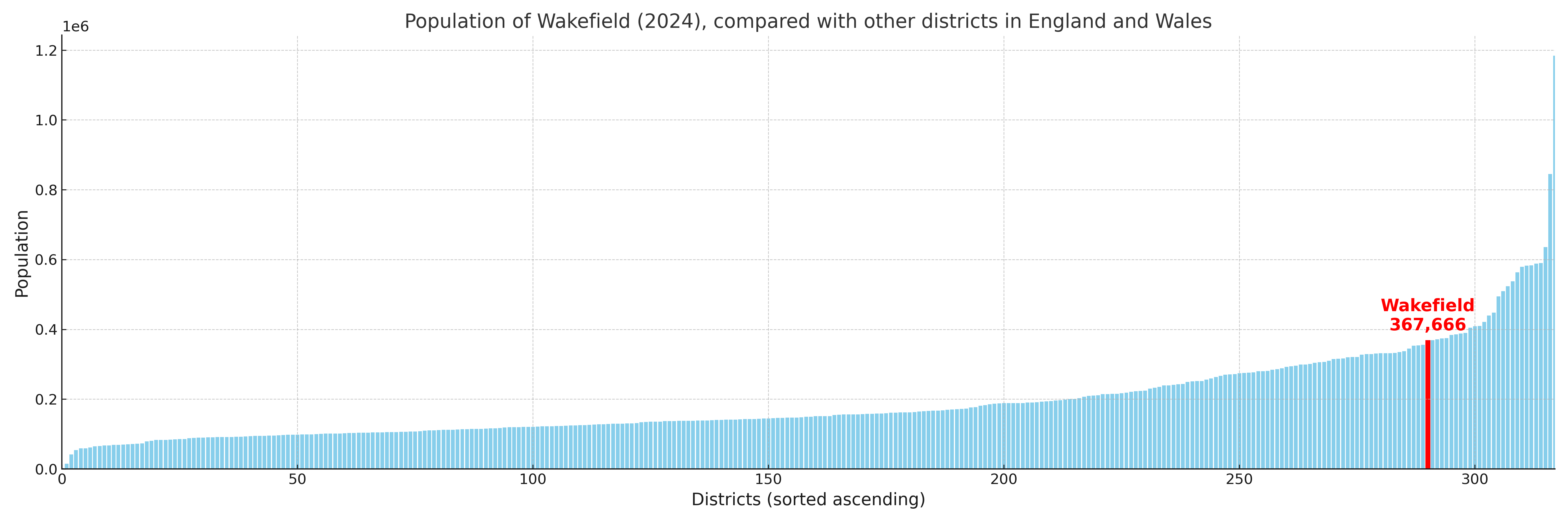
Wakefield compared with other districts in the UK
This section shows how Wakefield compares with other local authority districts in the UK, using a variety of measures and rankings.
Wakefield has 21 electoral wards.

Wakefield has a population of 367,666 (2024 mid-year estimate by ONS)
Population and Migration Trends in Wakefield
This chart shows the population trend for Wakefield from 2015 to 2024. It provides a quick overview of whether the local authority is growing, stable, or declining over time, and helps set context for the migration patterns shown below.
Population change is influenced by natural change (births minus deaths) and migration. The net migration chart below focuses on migration, separating internal migration (moves within the UK) from international migration (moves to and from abroad). Positive values indicate net inflows, while negative values indicate net outflows. The rate labels (per 1,000 residents) help compare migration intensity across years, even when the population size changes.
More local statistics and data for Wakefield can be found on the ONS statistics for Wakefield.
Latest news about Wakefield
Use the search box, or suggested search phrases, below to find recent news, council updates, planning stories, housing developments, transport changes, public services news, local elections, community issues and other local developments related to Wakefield. Results may include coverage from UK national, regional and local news websites, as well as official public-sector and local democracy sources.
- Wakefield council
- Wakefield planning
- Wakefield local elections
- Wakefield housing
- Wakefield transport
- Wakefield regeneration
- Wakefield public services