Sheffield
§ This page gives an overview of the Sheffield local authority district, bringing together key facts, maps, and data to help you quickly understand the area. This is one of 361 LAD profiles on Baseview.
Overview ⁞ Sheffield, known as the "Steel City," lies where the River Don and River Sheaf meet, surrounded by hills and green spaces. A third of the district lies within the Peak District National Park, giving it more parkland and woodland than almost any other major UK city. Landmarks include Sheffield Cathedral, Kelham Island Museum, and the Winter Garden, alongside vibrant neighbourhoods and cultural venues. Its industrial legacy as a global centre of steelmaking is balanced by a modern identity as a hub for education, innovation, and the arts. Sheffield’s blend of urban dynamism and natural landscapes gives it a unique character among English cities.
What County is Sheffield in?
Sheffield is in the ceremonial county of South Yorkshire, in the Yorkshire and the Humber region of England. South Yorkshire is one of the metropolitan counties created in 1974, and it also includes the neighbouring boroughs of Rotherham, Barnsley, and Doncaster. For modern administrative, ceremonial, and statistical purposes, Sheffield is officially part of South Yorkshire.
Historically, however, Sheffield was part of the West Riding of Yorkshire, within the wider historic county of Yorkshire. This is why Sheffield is often still described as being “in Yorkshire,” especially in cultural, sporting, or traditional contexts. In short: officially Sheffield is in South Yorkshire, but historically and culturally it belongs to Yorkshire.
Sheffield Boundary Map
This map shows the official boundary of the Sheffield local authority district, based on the latest geographic data published by the Office for National Statistics (ONS). It provides a clear view of the district’s extent and helps you understand how the area fits within the wider regional and national landscape.
Contains OS data © Crown copyright and database right 2025. Source: Office for National Statistics licensed under the Open Government Licence v3.0.
The administrative boundary of Sheffield can also be viewed on OpenStreetMap: District Boundary of Sheffield.
Key Facts about Sheffield
What region is Sheffield in? Sheffield is in the Yorkshire and The Humber of England, a region within the UK.
What county is Sheffield in? Sheffield is located in the county of South Yorkshire.
Is Sheffield a city? Yes, Sheffield is a city. Sheffield holds official city status as one of the 76 designated cities in the UK.
Who governs Sheffield? The local government for this district is: Sheffield City Council (Metropolitan District).
▶ Official website of Sheffield City Council 🔗 sheffield.gov.uk
Which police force covers Sheffield? Policing in Sheffield is provided by South Yorkshire Police 🔗 southyorkshire.police.uk, which serves 4 local authority districts: Barnsley ⁞ Doncaster ⁞ Rotherham ⁞ Sheffield.
Sheffield in International Geographies
In the International Territorial Levels (ITLs) hierarchy, Sheffield is an ITLs Level 3 area:
- (ITL 1) Yorkshire and The Humber
- (ITL 2) ⇒ South Yorkshire
- (ITL 3) ⇒⇒ Sheffield
The International Territorial Levels are used by OECD member countries for statistical purposes to classify administrative areas. We have this listable page for easy browsing of ITL names and codes: International Territorial Levels.
Constituencies in Sheffield
Sheffield is divided into 6 parliamentary constituencies, listed below in alphabetical order.
- Penistone and Stocksbridge
- Sheffield Brightside and Hillsborough
- Sheffield Central
- Sheffield Hallam
- Sheffield Heeley
- Sheffield South East
A constituency is a specific geographical area that elects one Member of Parliament (MP) to represent them in the House of Commons. The United Kingdom is divided into 650 parliamentary constituencies, 54 of them are in Yorkshire and the Humber region. We have this list page for easy browsing of all UK parliamentary constituencies: List of Constituencies.
Wards in Sheffield
Sheffield is divided into 28 wards, listed below in alphabetical order.
- Beauchief and Greenhill
- Beighton
- Birley
- Broomhill and Sharrow Vale
- Burngreave
- City
- Crookes and Crosspool
- Darnall
- Dore and Totley
- East Ecclesfield
- Ecclesall
- Firth Park
- Fulwood
- Gleadless Valley
- Graves Park
- Hillsborough
- Manor Castle
- Mosborough
- Nether Edge and Sharrow
- Park and Arbourthorne
- Richmond
- Shiregreen and Brightside
- Southey
- Stannington
- Stocksbridge and Upper Don
- Walkley
- West Ecclesfield
- Woodhouse
In the UK, a ward is a subdivision of a local authority area, used mainly for electoral and statistical purposes. Defined by the ONS, wards represent the primary unit for local elections, each returning one or more councillors to the local council. Wards are also used as a key geography for presenting population and census data. We have this list page for easy browsing of all electoral wards: List of all Electoral Wards in the UK.
Parishes in Sheffield
Sheffield is part-parished: 3 civil parishes (listed A-Z below) alongside 7 unparished areas.
- Bradfield
- Ecclesfield
- Stocksbridge
A civil parish is the lowest tier of local government in England, used for villages, small towns, and suburbs. They have their own local authority, either a parish council or a parish meeting, which provides local services like managing parks, allotments, and streetlights, and represents the community's views to larger councils.
We have this list page for easy browsing of all parishes: List of Civil Parishes in England and Wales.
Post Towns in Sheffield
Below is a list of post towns in Sheffield, grouped by postcode area:
S ▸ Sheffield (S1 / S2 / S3 / S4 / S5 / S6 / S7 / S8 / S9 / S10 / S11 / S12 / S13 / S14 / S17 / S20 / S21 / S25 / S26 / S35 / S36 / S95 / S96 / S97 / S98 / S99)
The UK postal hierarchy begins with broad postcode areas (such as “CB” or “M”), which are divided into smaller postcode districts (such as “CB8” or “M1”) to support accurate mail routing. Each postal address is anchored by a designated post town, the official locality name used in the UK postcode system, which operates independently from Local Authority Districts —the administrative boundaries used for council tax and local government services. Because they serve different purposes, a property’s postal address and its local authority district do not always align exactly.
Built-up Areas in Sheffield
Sheffield covers 12 built-up areas, listed below in alphabetical order.
- Brinsworth *
- Chapeltown and High Green *
- Deepcar
- Ecclesfield and Grenoside
- Highlane *
- Oughtibridge *
- Rotherham *
- Sheffield *
- Stocksbridge
- Thorpe Hesley *
- Wharncliffe Side *
- Worrall
In the UK, a Built-up Area (BUA) is a continuous urban area of at least 20 hectares (0.2 km²), defined by the ONS as land where buildings are generally no more than 200 metres apart, such as towns, cities, or large villages. (Note: A BUA name marked with an asterisk (*) indicates that the area is situated partly in the district of Sheffield.)
We have this list page for easy browsing of all built-up areas: List of all Built-up Areas in GB.
Railway Stations in Sheffield
Sheffield is served by a number of National Rail stations, providing rail connections to nearby towns, cities, and destinations across Great Britain. The railway stations listed below are located within the Sheffield Local Authority District and are grouped by train operating company for clarity.
- East Midlands Railway ▸ Sheffield (S1 2BP)
- Northern Trains ▸ Meadowhall (S9 1JQ) ⁞ Chapeltown (South Yorkshire) (S35 2UU) ⁞ Dore and Totley (S17 3LB) ⁞ Woodhouse (S13 7RF) ⁞ Darnall (S9 4JU)
This is a district-level view only. For a complete list of all National Rail stations across Great Britain, see the UK National Rail Stations Directory.
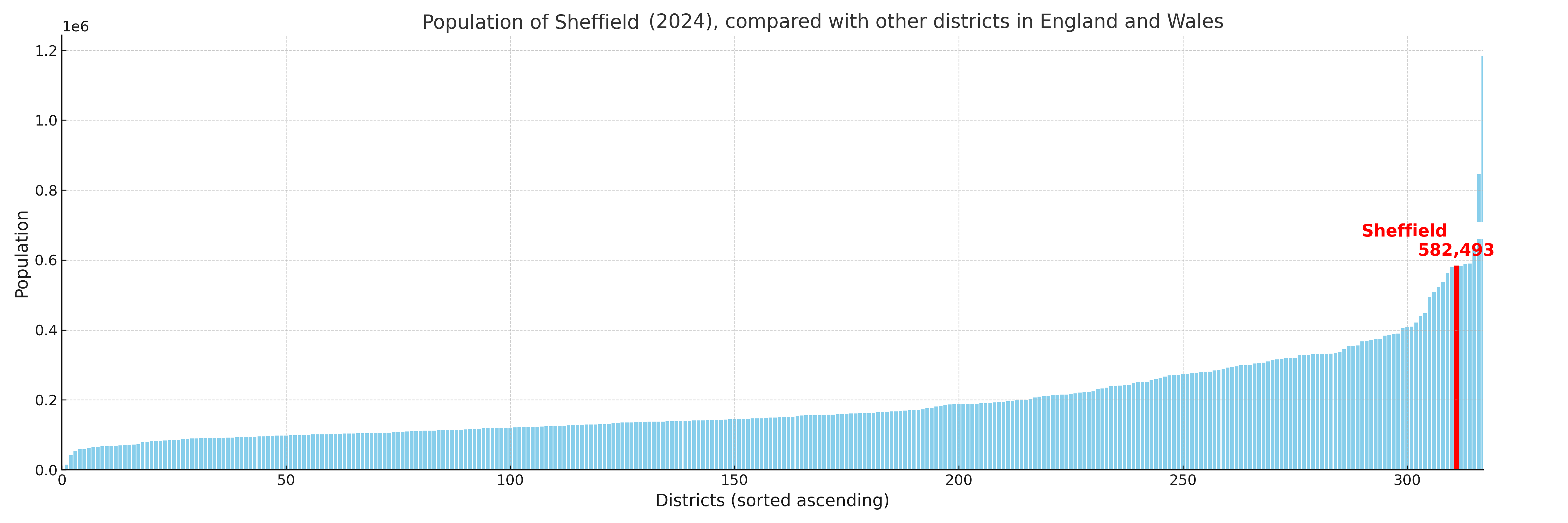
Sheffield compared with other districts in the UK
This section shows how Sheffield compares with other local authority districts in the UK, using a variety of measures and rankings.
Sheffield has 28 electoral wards.

Sheffield has a population of 582,493 (2024 mid-year estimate by ONS)
Population and Migration Trends in Sheffield
This chart shows the population trend for Sheffield from 2015 to 2024. It provides a quick overview of whether the local authority is growing, stable, or declining over time, and helps set context for the migration patterns shown below.
Population change is influenced by natural change (births minus deaths) and migration. The net migration chart below focuses on migration, separating internal migration (moves within the UK) from international migration (moves to and from abroad). Positive values indicate net inflows, while negative values indicate net outflows. The rate labels (per 1,000 residents) help compare migration intensity across years, even when the population size changes.
More local statistics and data for Sheffield can be found on the ONS statistics for Sheffield.
Latest news about Sheffield
Use the search box, or suggested search phrases, below to find recent news, council updates, planning stories, housing developments, transport changes, public services news, local elections, community issues and other local developments related to Sheffield. Results may include coverage from UK national, regional and local news websites, as well as official public-sector and local democracy sources.
- Sheffield council
- Sheffield planning
- Sheffield local elections
- Sheffield housing
- Sheffield transport
- Sheffield regeneration
- Sheffield public services